![]()
The Historic Columbia River Highway
in Oregon
![]()
The Historic Columbia River Highway
in Oregon
The Town of Rufus
By Curt Cunningham
In The Dalles Chronicle issued on July 20, 1895 there is an article about the town of Rufus. The founder of the town, Rufus Carroll Wallace, (Wallace was sometimes spelled Wallis) was in The Dalles that summer day on business. He said since the flood of June 1894, the town of Grant had become almost deserted, and the town of Rufus, 2 miles east, began to show signs of prosperity. He said that many new buildings had been erected that season, and there were other evidences of enterprise and progress.
Earlier that year Wallace had established a steam ferry on the Columbia connecting Rufus with Chamberlain Flat which is on the north side of the river in Washington. The flat was named after Griffin Chamberlain who had settled there the the 1850's. Wallace also said that from Chamberlain Flat there were good roads to Goldendale and other points in Klickitat county. About 1905 the railroad town of Cliffs was founded on Chamberlain Flat and it peaked in 1910. After Wishram came into existence Cliffs began to fade. In 1957 Cliffs was abandoned due to the rising waters behind The Dalles dam which inundated the town.
In 1895 there was a good road from Rufus o Wasco, and a great deal of freighting was done from Rufus to different points in Sherman county. Rufus became a prosperous shipping point for the railroad and they made a lot of money shipping out grain and bringing in supplies. That summer, wheat was arriving daily from the previous year's crop and Wallace did not believe the farmers would be through hauling this grain before the coming harvest. There was no sand surrounding Rufus, and this was a great consideration for hauling in the heavy loads to be shipped out on the railroad.
Wallace continued to say that if the stages to Wasco and Goldendale were to make Rufus a stopping place, the town would soon build up. He said that there was every prospect of this being done in the future. Wallace was very hopeful for the town he founded, and he expected to see it become a leading place in Sherman county.
Rufus Wallace was originally from Chamberlain Flat and in the 1860s he moved south across the river. In 1886 he established the a post office which was called Wallace. In 1890 a hotel began operations there. Whe the railroad came through Rufus became a flag stop on the O. R. & N. but it became an important wheat shipping point. By 1898 the town had a hotel, livery stable, a store, saloon, telegraph office, bakery, church, grain storage warehouses, a school and the Wallace ferry.
In addition to the steam ferry which was operated by Wallace, a small launch was used to ferry people across the river between Rufus and Chamberlain Flat. The naphtha powered launch was named the Rufus. Ferry service lasted until the 1957 when The Dalles dam was constructed. There were 2 known steamers built at Rufus, one was the Yukon and the other was the Columbia. On May 22, 1902 it was reported that the Columbia was launched and her engines were set in place. The steamer was an 80 foot long stern wheeler and had a pointed bow. The steamer operated on the Columbia river transporting produce grown by the small farmers who lived near the river.
In 1917 rail transportation was becoming congested due to war preparations. This prompted Sherman county to make plans to establish the port of Rufus. The primary commodity would be wheat and they wanted to use the river to transport it to the markets. At the time the upper Columbia river was not being utilized for shipping. The Port of Rufus was established in April of 1918 and its boundary was from Biggs to Wasco on the west, Klondike on the south and the John Day river on the east. It was the first port district organized under the cooperative plan between Portland and the Upper Columbia communities.
In February of 1920 the Inland Empire Boat &, Truck Line purchased from Captain A. B. Graham the Grahamona. The steamer was then repaired and converted from a wood burner to an oil burner. M. E. Lee supervised the conversion and he was the organizer of the company. The Grahamona was used between Rufus and Kennewick. Captain Graham was the manager of the company and Captain Clyde Raabe was the operator.
There was only one hotel in the town of Rufus which began operations around 1890. After the completion of the Columbia River Highway and traffic began to flow through the little town, the hotel was moved closer to the new road. In 1929 the hotel burned to the ground after a fire started in the kitchen.
The first road west of Rufus ran along the foot of the bluff to Grant. Here it connected to the ferry landing. When the Columbia River Highway was first constructed through to Rufus this road was utilized. Through town this old road is known today as 2nd Street. Just south of the 1936 bridge at the east end of town is the older bridge on 2nd Street. Today a beautiful tile work has been added to the railings. Not sure when this work was done. on the 1934 Metsker's map it shows a bend in the road at the Grant ferry landing and a new alignment going east into Rufus.
I am not able to find this newer section though it may have been an error and the old road ran along the old road at the foot of the bluff. By 1947 a new alignment (probably built in 1936) had been constructed that ran along the south side of the railroad into Rufus to the 1936 bridge. Today you can still see remnants of this old alignment along the railroad at Grant. By the 1950's another alignment was constructed which is the current route of Highway 30 through Rufus.
The Pontoon Bridge
In The spring of 1945 army engineers wanted to practice a river crossing that would approximate conditions they might face on the Rhine river when they were ready to invade Germany during World War II. They had chosen a section of the Columbia river near Rufus, and a camp was set up. The army then sent several hundred officers and men of the Army Corps of Engineers to learn how to quickly build a strong pontoon bridge across the river. The army wanted the bridge strong enough to carry 45 ton tanks, yet be mobile enough for field troops to transport it over rough terrain under battle conditions.
The engineers first worked for a few months on devising the bridge. They were aided by a French engineer who was familiar with the Rhine country along with an American bridge builder who had experience building bridges over the Rhone river in France. The 60 foot pontoons were cut into 2 pieces so they could be easily handled over rough terrain. The engineers then came up with a new way to connect the pontoons together. After some trial and error they perfected a bridge which could be thrown across the Columbia in 7 hours which could support a concentrated load of 56 tons. The experimental bridge had a cost of $34 million.
After they completed the test, Lt. Colonel G. S. Witters was satisfied with this crew's work. He said it would take only 7 hours to cross the Rhine with this bridge capable of supporting 54 tons. Lt. Col. Witters then said; "we have developed the best type of floating bridge in the world and we expect it will do a job in passing American armies across the Rhine on their way to Berlin."
The day then came for the epic crossing of the Rhine river near Remagen. Many had said that the they would be lucky to bridge the river in 36 hours under fire. Because of the army's practice on the mighty Columbia it paid them dividends and the bridge went across the Rhine in about 7 hours, and the heavy tanks and materiel sped over the river to launch the U. S. Army's great drive into the heart of Germany. The bridge would also be used at other points along the Rhine.
It was later said that the little community of Rufus, where the wheat came down from the high hills to warehouses along the railroad, and where a school and service station were the chief signs of village life, could take deep pride in the fact that there the army engineers learned how to complete the crossing of a great river and then applied that lesson thousands of miles away resulting in a saving of many lives and the speeding of an allied victory. Today a sign marks the location of the camp which can be found along Highway 30 west of Rufus.
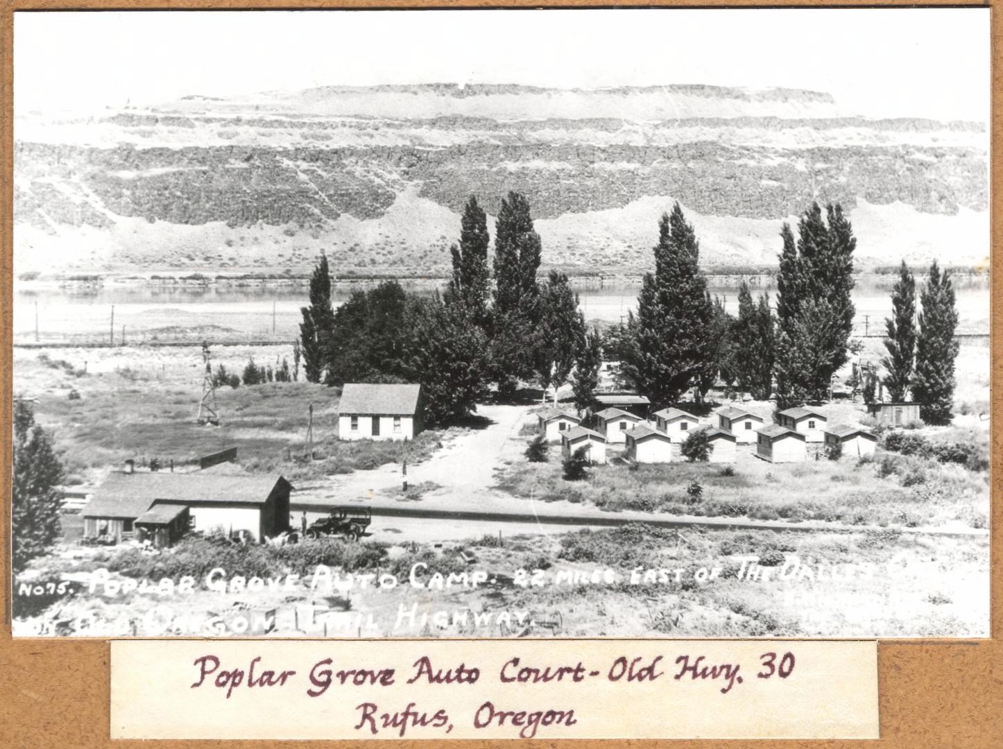
Poplar Grove Auto Court - Rufus
Photo courtesy Oregon Historical
Society
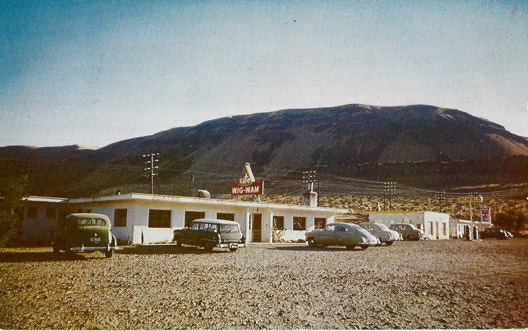
The Wig-Wam Cafe near Rufus in the 1950's. This cafe was located at the mouth of the John Day River 4.5 miles east of Rufus.
Camp Rufus - The Oregon Encyclopedia
Some Good Websites about the Columbia River and Highway
The Columbia River a Photographic Journey
Recreating the Old Oregon Trail Highway