![]()
The Historic Columbia River Highway
in Oregon
![]()
The Historic Columbia River Highway
in Oregon
The Historic Columbia River
Highway
Source; Wikipedia
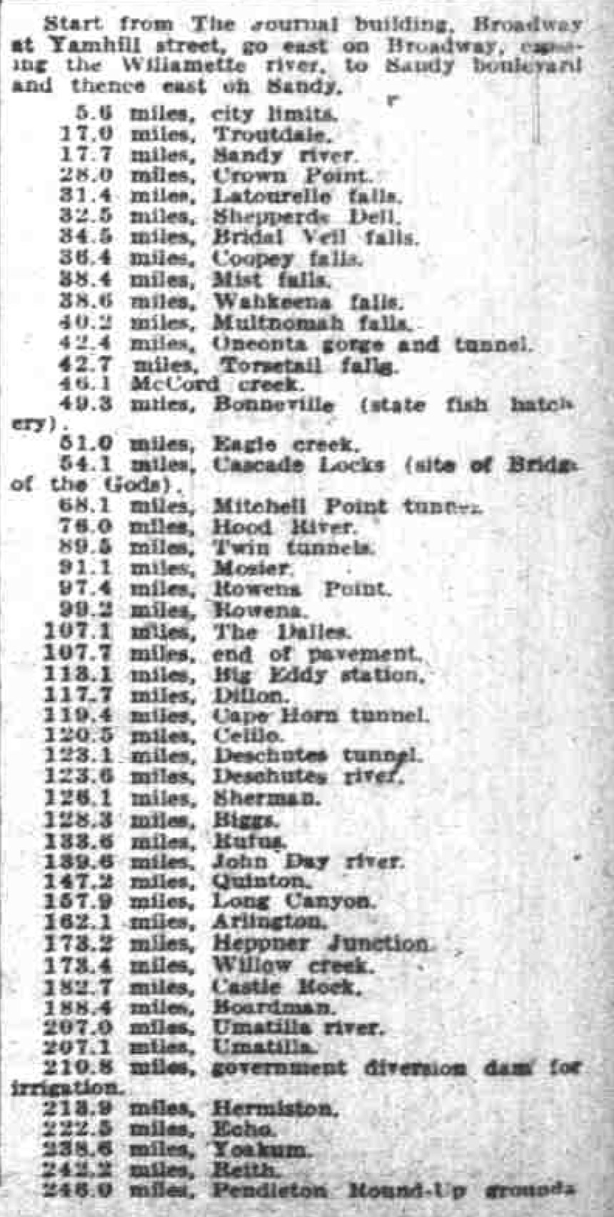
The Historic Columbia River Highway is the nation's oldest scenic highway. The original 300+ mile road began at Seaside, OR and terminated at Pendleton, OR. This historic road was also a section of the northern link of the Lincoln Highway and met up with this famous transcontinental route at Rock Springs, WY.
Today it is a 75-mile-long scenic highway in the state of Oregon between Troutdale and The Dalles. The highway was built through the Columbia River Gorge between 1913 and 1922 as the first planned scenic roadway in the United States. In 1983 the road was listed on the National Register of Historic Places. In 1984 National Historic Civil Engineering Landmark by the American Society of Civil Engineers. In 2000 it was designated as a National Historic Landmark by the U.S. Secretary of the Interior. It is considered as destination unto itself as an All-American Road by the U.S. Secretary of Transportation.
By the 1950's the historic roadway
had been bypassed by Interstate 84. The road is now mostly owned and maintained by the state
and designated as the Historic Columbia River Highway No. 100. Though in
places it is marked as U.S. Route 30. The original highway was envisioned by
road maker Sam Hill and engineer Samuel C. Lancaster, and was to be modeled after the great scenic roads of Europe.
The roadway was constructed like a railroad grade eliminating the steep
inclines of the former wagon road, and it was not just a means of traveling, but
it was designed with an elegance that took full advantage of all the natural beauty along the route.
When the United States highway system was officially established in 1926, the highway became
a part of U.S. Route 30. Since then, modern Interstate 84 has been built parallel to the
old highway between Portland and The Dalles, replacing it as the main travel route and resulting in the loss of some of the original sections of road.
Modern highways, including I-84, and other developments have resulted in the abandonment of major sections of the historic original highway.
In the interest of tourism and historical preservation,
74 miles of the original road from Troutdale to The Dalles have been established as the Historic Columbia River Highway. Forty miles of the route are open to motor vehicles:
The remaining portions of the highway has been designated for non-motorized use
now known as the Historic Columbia River Highway State Trail. Roughly 7 miles between Hood River and Mosier have been open to non-motorized traffic since 2000, passing through the historic Mosier
Tunnels.
The historic highway now serves as a scenic and alternative bicycle route for I-84 and US 30 between The Dalles and Portland.
Currently (2023), cyclists wishing to travel between these two towns must ride on the shoulders of I-84 for much of the distance, or the much more dangerous and narrow State Route 14 on the Washington side of the river.
The Great Columbia River
Highway
East Oregonian Round-Up Souvenir
Edition
September 25, 1915
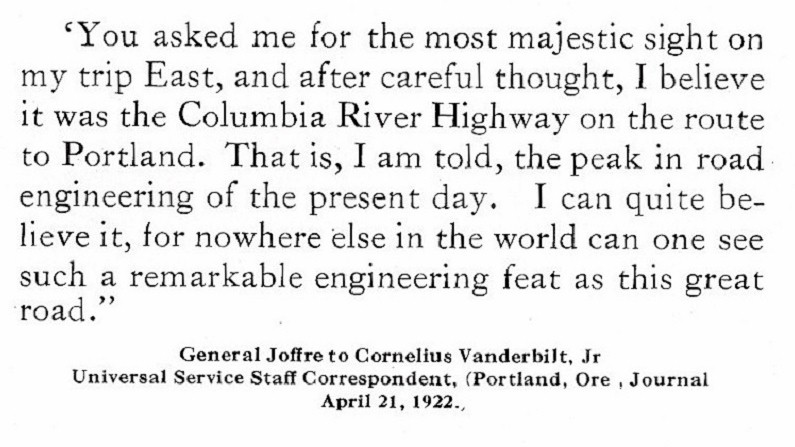
When Major General George W Goethals, builder of the Panama canal, passed over the Columbia River Highway between Portland and Cascade Locks on Wednesday, September 1, 1915, he said; "The Columbia River Highway is a splendid job of engineering and is absolutely without equal in America for scenic interest." For more than a century men have dreamed of a road that should enter the Oregon country from the east. Several attempts have been made to surmount the barriers which have so long existed, but the forces of nature were greater than man and the fight always has been an unequal one until the task was undertaken by a group of strong business men who thought the time had arrived for the construction of a great highway suited to the traffic of the times and place.
It was therefore determined to construct a road 24 feet in width with a maximum grade of 5 per cent and no curve to have a radius less than 100 feet. It was necessary to construct a, number of large bridges, some of them spanning deep chasms. All of the bridges are of reinforced concrete and each was designed to meet the particular condition which existed at each point. Some of the bridges are of an entirely new design, yet all of them are pausing in appearance and constitute one of the principal attractions of the highway.
The road extends from the wheat fields of eastern Oregon through the Cascade range, enters the city of Portland and passes on the west through a splendid agricultural and timber region to Astoria and the seashore. It was officially opened from Hood River to Portland July 6, 1915, and on August 11, 1915, a large number of representative citizens, led by Governor Withycombe, drove over the newly constructed highway from Portland to the sea.
That part of the Columbia River Highway which lies within the boundaries of Multnomah county is being paved for a width of 18 feet, with a two foot rock shoulder on each side, a total width of surfacing of 22 feet, and for a distance of 42.5 miles from the city of Portland east to the Hood River county line. Fully through the Gorge of the Columbia one-half of the hard surfacing is now completed and it is as smooth and even as the finest residential street.
In designing the road much care was given to the study of alignment in order to make the road safe and provide an unobstructed view ahead. There are no sharp reverses from one curve to another. This feature was kept in mind in order to permit the outer side of all curves to be elevated, and thus add materially to the comfort of the road.
Natural Beauties Preserved.
In fixing the location the first consideration
was always to preserve the natural God made beauty, for it would have been a crime to
mutilate the lovely landscape which was made for a divine purpose, to influence
the lives of men and women and impress them with the all-powerful hand of the Creator of the Universe,
for here He parted a mountain range like a curtain to permit one of the great rivers of earth to pass through
almost at the level of the sea. The tides ebb and flow to within a few miles of the
dlvide in the range. Seals from the ocean often are seen feeding on salmon. In the very heart
of the range eagles are seen to disport themselves about their nests
on the mountain tops.
Here is where the sparkling waterfalls leap down the crags. Here the beauties of sea, mountain and sky charm all who come by steamer, rail or pass along the great highway from which the best views are always obtained. The city of Portland is situated at the junction of the Columbia and Willamette rivers, in the center of a rich agricultural region. The broad Willamette valley stretches away more than 100 miles to the south, and to the east the Columbia River Highway passes through a rich farming section which ascends to a point 22 miles east of the city at Chanticleer, where the first and, perhaps, finest view of the Gorge of the Columbia is obtained.
The elevation at this point is 925 feet above the sea. Rooster Rock, almost 300 feet in height, rises out of the water just below Crown Point which is 725 feet in elevation. From a point just east of Chanticleer the road descends on a 5 per cent grade and is blasted out of the side of the mountain for more than 3/4 of a mile. This is the Corniche of the Pacific coast, and it is fully equal to the great European road which is known to all continental travelers.
Although the road is hung around the face of the cliff like the cornice on a towering building. It is everywhere 24 feet in width, is paved like a city street and at all dangerous points the traveler is protected by a heavy rock wall on which there is a concrete coping that is heavily reinforced with bars of steel, it is more than 800 feet from the roadway to the floor of the valley below. Descending to Crown Point the road encircles the top of the rock, which it fits like a crown, the radius being 110 feet. Two hundred and twenty-five degrees of curvature are turned.
The road has an extra width and is 35 feet wide in the middle of the curve A heavy concrete railing four feet in height and a seven foot concrete sidewalk and curb form the outer protection around Crown Point. There is a reinforced concrete lamp post, with a frosted electric globe 14 inches in diameter at every 20 feet that adds a charm to the scene. The tides ebb and flow at the base of the rock and it is more than a mile to the opposite shore. Here the Columbia river may be seen stretching away toward the sea to the west, and to the east one can look through the Cascade range for a distance of more than 35 miles.
The mountains to the north lift their heads for more than a mile in height. The white snow on their summits, the green fir, hemlock and spruce of the timbered area lower down forms a beautiful background for the rectangular plots where fertile fields, orchards and lawns are seen on the heights above the mighty river. The road continues to descend from Crown Point; then for more than a mile it is blasted out of solid rock. Here it commands a superb view of all the surrounding country, with ever-changing scenes.
Latourelle Falls is the next point of interest. This is a beautiful waterfall 224 feet in height which pours its shining waters over the vertical walls of a basalt cliff. A reinforced concrete bridge spans the stream just below the waterfall. There are three 80-foot concrete arches and the bridge is 100 feet in height. The distance between Crown Point and the bridge at Latourelle Falls was not sufficient and it was necessary to develop distance in order to reach the lower level on a maximum grade of 5 per cent, so the road was looped back and forth and it parallels itself five times in a beautiful forest where ferns abound.
Shepard's Dell Entrances.
Sheppard's Dell is a gem of rare beauty and is not exceeded by anything in the world. Beetling crags look down from great heights. A beautiful arch of concrete spans a narrow chasm. A crystal waterfall sparkles in the depths of the covered, tree-clad gorge. The view on the opposite side is out over the broad valley of the Columbia to the west toward Crown Point. George Sheppard, a man with a great heart though of small means, gave eleven acres to the public for a park were men and women might be recreated and enjoy the beauties of nature.
There are many beautiful scenes all along the highway between Sheppard's Dell and Benson Park. The park la the gift of another citizen of Portland, a man with a large heart and of means. Mr. S. Benson has made it possible for his fellows to enjoy for all time one of nature's masterpieces. This park of more than 100 acres extends from the shores of the broad river to the level land above the rim-roc- Wahkeena (most beautiful) Falls has its sources at an elevation of more than 1200 feet where it bursts in a gushing stream from the side of the mountain.
It is clear and cold and as it comes laughing and leaping it sings a delightful song and falls in many cataracts over the precipitous cliff. An easy foot and pony trail wends its way up the side of the mountain in plain view of the water brook and meets another trail which comes from Multnomah falls, a half mile further east on the Columbia River Highway. The stream at Multnomah falls is spanned by a beautiful concrete arch. The foot and pony trail crosses the lower falls on a lace-like arch of concrete which is also the gift of Mr. Benson.
The trail continues, threading its way through the forest, passes over the rim-rock and enters a box canyon high up over the side of the mountain where there are many beautiful waterfalls. Here it unites with the trail from Wahkeena falls and continues to the summit of Larch mountain, 4,000 feet above the highway and six and one-half miles distant by trail, although just a little more than three miles on an air line. Larch mountain may be called nature's grandstand. Five great volcanic peaks, always white with snow, can be seen and no words can describe the beauty there unfolded.
Plans have been perfected for the use of pack mules and burros for carrying next season's tourist travel and every arrangement will be made for comfort and convenience. The national government controls the trail and no charge whatever is made for its use.
New Type of Viaduct.
It was necessary to construct near Multnomah falls a type of reinforced concrete viaduct which, it is believed, entirely original. Steep talus slopes of the mountain extend to the railway tracks. The loose rock could not be disturbed and in order to meet this condition, reinforced concrete columns were constructed with concrete footings twelve feet from the center of the railway track and of sufficient height to give the required width of roadway, the other side of which rested on the mountain. A diagonal strut extended from the foot of the column up to the roadway on the side of the mountain to insure its stability.
The railing is of reinforced concrete and the outer edge is only 10.5 feet from the center of the railway track. Near Multnomah falls there are some interesting walls constructed of dry masonry, some of them being as high as 30 feet. There are two and one-half miles of dry masonry walls, of an average height of 11.5 feet. There is a magnificent view all the way from Multnomah falls to Oneonta Gorge, where the mountain was cleft. In the depth of the gorge is a waterfall 300 feet in height.
The gorge is crossed by a concrete bridge near where the highway enters a tunnel. Emerging from the tunnel the wild grandeur of the towering cliffs, which rise more than 2,000 feet abruptly, is inspiring. Horsetail falls is less than a quarter of a mile beyond the tunnel. It is 205 feet in height. From Horsetail falls to McCord creek the road is built along the floor of the valley and every foot of the way is interesting. The McCord creek viaduct is 365 feet in length and 65 feet in height.
Beginning at this point is a park of 14,000 acres set aside by the United Stales forest service for recreational purposes. It stretches along the highway for 22 miles to the east in the very heart of the Cascade range and can be reached in less than two hours on a smooth, paved road from a great metropolis. Less than a mile from McCord creek the deep gulch through which Moffett creek flows is spanned by a concrete arch 170 feet in length. The rise in this span is only 17 feet. The Moffett creek arch is the largest single flat arch in America and, it is believed, the largest three-hinged arch in the world.
The broad highway continues to Eagle creek. From the divide just west of Eagle creek the road ascends 200 feet on a 5 per cent grade and swings around the rock above the railroad track. Passing through a point of the rock, then over a reinforced concrete viaduct, the road again passes through a point of rock and is bracketed out on the side of the cliff 200 feet above the rim and railway track. Descending to Eagle creek the road crosses a 60 foot stone arch which is a complete half-circle.
Swinging on a long, graceful curve, It again overlooks the Columbia river and the rapids below Cascade Locks. The foaming waters and the high mountains are in plain view all the way to the town of Cascade Locks, in Hood River county.
Mitchell's Point Unsurpassed.
The county of Hood River has joined hands with Multnomah county in extending the road through to the beautiful Hood River valley. At Mitchell's Point a difficult problem had to be met. It was necessary for the state to provide the sum of $50,000 to meet the cost for less than one mile of heavy construction. A tunnel was bored along the face of the rock cliff which overhangs the railway track. The construction is similar to the famous Axenstrasse of Switzerland, which has always been considered the most daring piece of highway construction in the world.
This tunnel Is 400 feet in length and there are five large windows overlooking the Columbia and the mountains beyond. The Axenstrasse has only three windows. It is no longer necessary for the people of America to look to Europe for scenic grandeur. The Pacific coast has scenery as grand as any in Europe or elsewhere. It is now accessible and the people of the great state of Oregon invite the world to come and see, for the half has not been told.
From a 1920's Portland Chamber of Commerce
Brochure
Submitted by Jeffery A. Fox
Some Good Websites about the Columbia River and Highway
The Columbia River a Photographic Journey
Recreating the Old Oregon Trail Highway
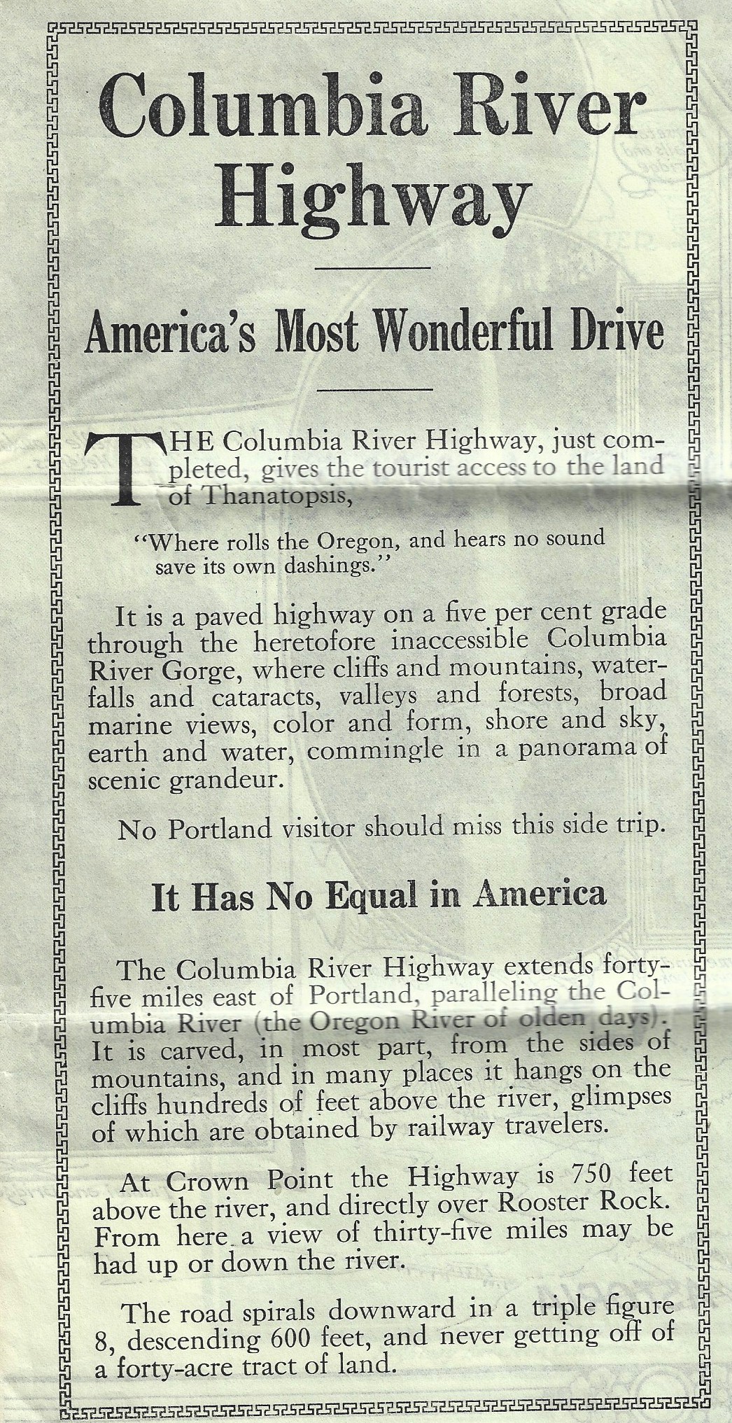
From a 1920's Portland Chamber of Commerce
brochure.
Courtesy Jeffrey A. Fox - 2022