![]()
The Historic Columbia River Highway
in Oregon
![]()
The Historic Columbia River Highway
in Oregon
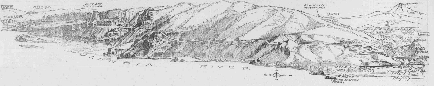
From the Sunday Oregonian September 25, 1919. Sketch made by by Fred A. Routledge.
Hood River to Mosier
By Curt Cunningham
The Columbia River Highway (CRH) between Hood River and Mosier is 6.5 miles in length and is one of most beautiful sections of the highway from both a scenic and engineering standpoint. This section of the highway opened in May of 1920 and cost approximately $50,000 a mile which in today's dollars is $774,834.40 per mile. Before this section was completed the old road over Mosier hill was treacherous and steep. After a good rain cars would have to be towed from the summit down the hill on the eastern side. Many who could afford it shipped their cars from Portland on a steamer to The Dalles.
The contract for this work was let to the A. D. Kern Co. in October of 1918, and during the spring and summer of that year steam shovels were busy cutting out a roadbed along the hillside overlooking the Columbia river at an elevation of 400 or 500 feet above the river. The total distance to be graded was 6.4 miles. One interesting feature of this section of road is a 270 foot tunnel about one mile west of Mosier. This tunnel, like the Bowlby tunnel which is now called the Mitchell Point tunnel west of Hood River, has windows overlooking the river, for observation and lighting of the tunnel. The original plan did not call for lining the tunnel.
The new grade ascends the hill by a series of loops to an elevation of about 500 feet, then takes a direct course to Mosier along the hillside around rocky points and through rocky draws. When the new grade was completed, the Old Mosier hill, which had been the most difficult and dangerous stretch of the old wagon road between Portland and The Dalles, was eliminated.
In the Sunday Oregonian issued on September 28, 1919 L. H. Gregory wrote about the anticipated opening of the Columbia River Highway between Hood River and Mosier. He said that; "If you never had the thrill of riding by automobile over Mosier hill, between Hood River and Mosier, this year is your last chance to have it. Long before the opening of another summer the Old Mosier hill mountain road, with its 25% and 30% pitches, its sharp curves teetering around canyon brinks, its record of many cars going over the grade, was eliminated from the route of the Columbia River Highway easterly from Hood River."
Arthur Fields of the Fields Motor Car Co. of Portland took a Chevrolet model 450 over this new stretch of highway and Gregory wrote in his article that; "it was a trip of a thousand surprises and scenic views, yet only a foretaste of what the drive will be over the completed highway. From Hood River the new highway climbs in four swinging loops up to the level necessary to start its course along the edges and sides of the high cliffs. Thence it passes through pleasant forests until at a point between two and three miles from Hood River. Far to the east and far to the west from the rocky promontory where it thus emerges the great river and the wondrous mountains of its canyon are in view."
"Across the way are the White Salmon bluffs and, seen in birds-eye, the towns of White Salmon and Bingen. Three miles along from Hood River the road is cut right out of the side of a bluff. A ledge has been hewn from the rock. Atop this ledge runs the highway, above it a towering precipice, off to the side the jump-off of another precipice down to the river bank. This ledge is not wide enough for the completed highway-to-be, it will be pieced out over the precipice edge with concrete, the foundations for which are now being blasted. For the assurance of the timid there also will be a stout concrete wall. But the new highway reaches its climax a mile further along at the Twin tunnels and beyond them. Here it skirts a perpendicular cliff, ever rising higher on an easy grade chopped out of the rock, until it attains its maximum elevation, 520 feet up at the Hood River-Wasco county line."
The Hood River-Mosier section of the Columbia River Highway involved the heaviest single construction project ever undertaken by the Oregon state highway commission at the time. The A. D. Kern Construction company was the contractor on the work. The contract was for $243,000, which was also the largest amount expended by the highway commission on any single road project at the time. Gregory ended his article by saying that this new highway section would be worth all its labor of construction and all its cost. "Let the old Mosier hill road rest in peace. It will not be forgotten, but neither will it be regretted. And as already said, let the motorist who wishes to look back upon the distinction of having driven his car over this old road hasten to his task, for the time is short."
The Twin Tunnels
The Twin tunnels are 270 feet and 72 feet long respectively. These tunnels are not as long as the Mitchell's Point tunnel west of Hood River but they are much higher. Mitchell's Point tunnel is less than 150 feet above the river and the Twin tunnels are at 300 feet above the river. The longer of these tunnels has two windows like those of the Mitchell Point tunnel only narrower. That September it was possible to drive from Hood River 4 miles east along this new grade.
The engineers had called the Twin tunnels "The Gateway," where just west of Lindsay creek, the passage was blown through fairly solid rock. Formerly the rocky hills obstructed the view. But since the road had been opened, a large slice was taken out of the gorge side, and one is able to see for a long distance up the Columbia, and thus the name. On October 29, 1920 the Gateway tunnels were reinforced with timber so those traveling through the spectacular tunnels just east of the Hood River county line, no longer feared having rocks from the tunnel's ceilings come crashing onto their autos.
Although comparable to the Mitchell Point tunnel in beauty, the Gateway tunnels force their way through cliffs of a different rock formation, and it was found impossible to fashion clean-cut tunnels through the rocks, as was done at Mitchell Point. Boulders and rock splinters kept falling from the sides and top inside the tunnels causing damage to the cars and blocking the road causing a dangerous situation. The reinforcing work was somewhat similar to that of the short tunnel at Oneonta gorge was used.
The Hood River-Mosier Section is Completed
On May 2, 1920 The Sunday Oregonian printed an article written by Joe D, Thomison on the completion of the Hood River-Mosier section of the highway. The Hood River-Mosier section of the Columbia River highway begins at the city limits of Hood River with a new concrete bridge constructed jointly by the state and Hood River county across Hood river at an expense of $48.000. The bridge was completed a year before the new grade was undertaken.
The new road, which is 6.5 miles long, follows the old county road along the east side of the Hood river gorge for about 300 feet, and then it turns northeast toward the Columbia river through a slight gap. The old grade, formerly narrow and unsightly, was smoothed into a graceful curve. After the gap is passed and the gorge of the small stream is left, the motorist climbs to about a third of the way up the Columbia canyon on an open hillside by a series of four loops that give the old field a terraced appearance.
No one who travels over the new road will forget the view of the city of Hood River, built on the gradual slope that arises to the west of the Hood river gorge. The town is set forth like a view from an airplane. The distance to the top of the loops by direct line is 1,000 feet. All the way around by the curves a car travels S,000 feet.
In past years successive generations of Hood River road builders had constructed three roads up from the town to the east side orchard district. The first was a mere trail, fairly passable for horseback traffic, over the hill. The second road, winding around passed, seeking easier grades, was not bad for mountain hack and wagon. Then came the days of the automobile. The east side grade, dug out of the rock and cement-gravel of the Hood river gorge, was completed around 1910.
The new CRH crossed them all, appropriating parts of these old routes here and there as required. Before the new highway was constructed Victor Beauregard operated a dairy ranch on the hillside where the cuts and fills of the four loops now greet the eye. The road had appropriated most of the Beauregard farm, and his ranch was limited to small plots like the beginnings of sunken gardens between the loops. Ex-Mayor H. L. Dumble owned a lot 100 feet square on the hillside. The survey of the new road crossed his lot diagonally, which resulted in two tiny triangles on either side of the portion of a loop.
About a mile east of Hood River the new road passes out of sight of the Columbia into a series of narrow ravines and miniature happy canyons, where the warmth of spring sunshine brings early flowers where trilliums, rock lilies and purple lupine paint nooks in colorful profusion. For half or three-quarters of a mile the motorist may revel in a mood of quietness. Then abruptly the road swings toward the Columbia gorge and a view of long stretches of the canyon up and down stream and the neat gardens and fruit tracts of Bingen bursts upon the traveler. Across the river chasm the homes and business structures of White Salmon, WA appear like doll houses.
For a mile the road runs along the side of the great gorge through groves of young fir trees. Creases in the gorge are crossed on deep fills or masonry work, and masonry walls arise on the outer edge of the road at dangerous points, from which one may stand and look almost straight down at the railroad tracks. From the forests the road crosses the only real break in the gorge along the entire route. After an easy grade up the hill the maximum elevation is reached along this great natural wall. The road was more than double width at the summit.
The point of the cliff juts into the gorge, and indeed forms a veritable aerie. Not long the first tunnel is reached and is the shorter of the two at 72 feet long. Then comes a break in the rock gorge and an open space of about 60 feet lets in the light of day. The second tunnel is 270 feet long. This tunnel slopes on about a 4% or 5% grade to the west. The Twin tunnels are not as picturesque as the Mitchell's Point tunnel with its open windows which were cut through giant jagged-grained rock that prevents a finish pleasing to the eye.
The rock wall from tunnel to cliff edge is thicker at the Twin tunnels than at Mitchell's Point which gives the traveler a beautiful view of the river. At the Twin tunnels the tourist will find it necessary to walk to the outer edge of the windows to gain the river view. The windows of this tunnel are more like little crosscuts of a mine. They are from 15 to 20 feet long. The traveler, however, is fully repaid by a walk to their ends opening over the Columbia. Crews arranged narrow trails, protected by a high coping, along the straight cliff from one tunnel to another.
The view is sufficient to strike the most eloquent man or woman silent for a moment. One cannot look up and down the Columbia and talk at the same time, but after leaving it one is likely to grow extravagant in expressions. All the way from the summit of the highway into Mosier one is struck by the change that takes place over the gorge landscape. To the west the gorge itself is green and the hills sloping back from the canyon are clad in a forest of firs. But as one goes east from the summit the hills and canyon sides grow barer.
From the tunnels the distance of one mile into Mosier is all down hill, over graceful curves again and through groves of stunted pine and oak trees. Mosier city limits are entered over a comparatively small but artistic concrete bridge spanning Rock creek. And thus one ends a 6.5 mile journey over the most costly piece of construction ever undertaken by the Oregon state highway commission at the time.
Old Road vs the New Road
In the October 30, 1921 edition of the Sunday Oregonian which said; With completion of paving of the Columbia River Highway between Hood River and Mosier on October 20, 1921, they compared the old hill road, which was dangerous and had tortuous grades, with the new boulevard, graceful in curvature and of easy gradient. The old road was constructed all the way from The Dalles to Mitchells Point, a distance of nearly 30 miles, for $5,000. The cost of cutting the 6.5 miles of new grade between Hood River and Mosier and the paving of the stretch in round figures reached $600,000.
More than $50,000 was required in building less than a
quarter mile of new grade at Mitchells Point, where the open-window tunnel was bored.
Since the old mountain road between Hood River and Mosier was completed in 1874, little improvement was
ever made to it. The grade was never changed and the curves remained hazardous for drives of large cars.
At points the sharp curves occurred on heavy grades, and the elimination of the old road brought sighs of
relief from every motorist who had ever negotiated that old road. The only material improvement that was
ever made in the 9 miles of highway was the betterment of a short distance just west of
Mosier.
Old Construction Recalled.
The late John Marden of The Dalles was in charge of construction of the original road, known as The Dalles-Sandy
road. The late E. L. Smith of Hood River was engineer in locating a part of it. James Wallace, civil war
veteran and local pioneer, whose son, Charles Wallace, once lived on an Oak Grove orchard, and was associated
with Mr. Marden in the construction work. The Oak Grove orchardist worked on the route with his father.
The most expensive part of the old road was that portion built around Shell Rock mountain near
Wyeth.
Here the pioneer road builders constructed, about 100 feet above the grade of the new highway, a wall. The west end of the old thoroughfare was swept away By slides of the mountain, which was made up of a mass of loose stones. The east end, however, remained a relic of pioneer days and a monument to the enterprise of men of those early times. The old roadbed was overgrown with hazelnut bushes and dogwoods, which, with their leaves in autumn gave a vivid purple, it paid nature's tribute to the memory of those progressive pioneers.
Porcupines and digger squirrels had
burrows under the old walls and chipmunks chattered there from safe recesses
as a stream of motor cars sped each way over the famed boulevard below. But the old grade,
where slides had left it intact, had stood the test of decades, and if the brush could be cleared away and an automobile
be raised to the height of the old road, a driver could have no difficulty in negotiating the remaining
smooth surface. The old state highway was abandoned on completion of the Union Pacific railway
line then called the OR & N, the railway tracks had used portions of the original road's right
of way.
New Scenery Available.
The newly paved 6.8 miles of the Columbia River Highway between Hood River and Mosier made available new scenery
for the motorist out for a spin over the scenic route. With the surfacing placed on through to the
Wasco county fruit section, Mosier, instead of Hood River, as had been the case in 1920, was the
goal of many parties out for the day from Portland. The new stretch leaves Hood River
and climbs to an approximate halfway point of the Columbia gorge east of the city by a series of graceful
loops. At present these loops, where gravel pits and were being worked on the
intervening property and other portions were being farmed, were somewhat of an eyesore. It was proposed that eventually
the state would take them over and landscape them.
Charming Views Provided.
The highway comes out above the Columbia about a mile east of Hood River at an elevation that provides
many charming views of the river and the lowland farms of the Blngen section in Klickitat county, Washington.
A maximum elevation of more than 500 feet is reached at the summit and a turnout was provided, and here
the motorist may drive to the side of the protecting parapet walls and look for many miles, both to the east and
west. Twin tunnels were bored through a promontory jutting out into the gorge and it had been suggested
that these tunnels should be named Gateway tunnels, for they really mark the dividing line between eastern and western
Oregon. Traveling to the east the when you leave the last bore and reach the
elevation it gives a view up the river and you are struck with the brown hillsides above
and the barren expanses of the north bank of the Columbia. You have left the
fir-clad hills of the mid-Columbia and instead of green shrubbery hugging every fold of the gorge, brown or gray areas
greet his eye and a new phase of Oregon's scenic attractions is opened up.
From the Sunday Oregonian September 26, 1920
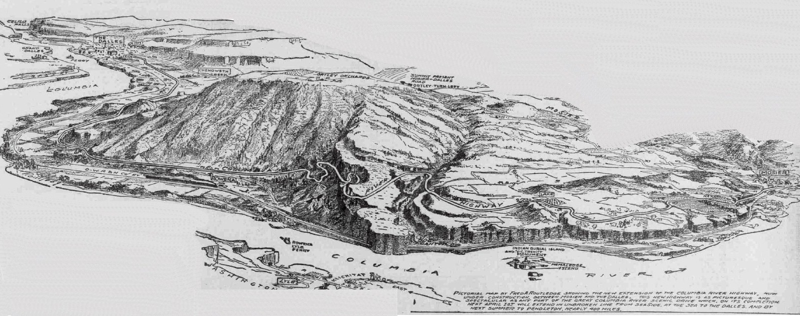
Mosier to The Dalles
The Columbia River Highway between Mosier and the Dalles was 16.5 miles when it was completed in May of 1921. The section of the highway travels through some of the most picturesque scenes on the entire route. From Rowena west a series of highway loops were needed to keep the highway at a 5% grade. This section became known as the "Rowena Loops."
Printed in the Oregon Sunday Journal issued on July 25, 1915 there was a small article about a detour between Mosier and Rowena which could be avoided by the construction of a new grade. At the time motorists had to detour 23 miles over a hilly country and a steep grade between these points. The Journal said that there was an old abandoned railroad grade which could be used. The gap between Rowena and Mosier is about 4 miles and the proposed construction which they said would be difficult, would cost according to an estimate approximately $40,000, which in today's money would be $1,191,445.54.
By 1915 the Columbia River Highway had been completed from Portland to Hood River (though it was not yet paved) and a strong sentiment had developed at The Dalles in favor of making this cut-off. Max Vogt, a banker, made a proposition to the county which would have advanced the necessary funds in order that the work could begin. But the county officials at the time had not decided on whether to accept the offer or not.
It appears the county did not take Vogt up on his offer and 4 years later in 1919 Amos Benson proposed a location for the Mosier-The Dalles link of the CRH which would include a great viewpoint at the top of the hill west of Rowena.
In the May 15, 1919 edition of the Oregon Sunday Journal is an article about the proposed link between Mosier and The Dalles. They said if a tentative location of the Columbia River Highway between Mosier and The Dalles proved to be practicable, another scenic surprise would be added to the highway and, like all others, it would be "sul genesis," which in Latin means; "of its own kind," or "in a class by itself," The proposal would also include a 300 or 400 foot tunnel through a rocky bluff at a point 500 feet above the level of the river.
The eastern portal of the tunnel would open on a small bench from which can be seen a magnificent and inspiring view of the river as far as Celilo, and the palisaded fringe of the Klickitat county hills on the Washington side and the roiling wheat fields of eastern Wasco and western Sherman counties, together with the orchards of the Rowena valley on the Oregon shore. It is to be a view that will send a thrill through the most blasé and scenery weary traveler.
It was out of the question to build the highway along the present route of the road, between Mosier and The Dalles. Going out of Mosier there was a climb on a 5% grade to a height of 1,500 or 1,600 feet and then a descent of seven miles on a grade of 7%. In the view of the state highway commission, the only thing to do. was to find a route along the river. The cost of construction would be reduced by reason of the existence of about nine miles of abandoned railroad grade which could easily be converted into the bed of a highway at a small expense.
The only difficult piece of construction was getting around the rocky headland through which the railroad had cut out a tunnel. The proposed route of the highway, leaving Mosier, adopts the old railroad grade for a distance of about two miles to the mouth of a canyon locally known as Hog canyon (Rowena Dell). The railroad directly crosses the mouth of the canyon and plunges into a long tunnel. The highway would proceed up the right hand side of the canyon valley for a distance of a half a mile or so on an easy grade, then cross and enter a short tunnel which would pierce a narrow constriction of the bluff.
Coming out on a small bench the road would then work down the side hill to Rowena, where the abandoned railroad grade again would be taken and used for seven or more miles, or almost to The Dalles. If the tunnel was feasible they said. "the only real construction would be about four miles, with the tunnel as a center."
The Mosier-The Dalles Section
is Completed
From the Sunday Oregonian issued on September 26, 1920
written by L. H. Gregory.
The Columbia River Gorge, east of Mosier where the west side of the Cascades gives way to the bare cliffs and brown hills of the east side of the mountains. This new highway link extends from Mosier to The Dalles, 16.5 miles as the grade is located. It no doubt will surprise most persons, as it surprised the writer when he drove over it in a Cole eight, to learn that so far as grading and hard construction work is concerned, it is now virtually built.
There is something about the Columbia River Highway that seems to make artists of all men who have anything to do with the building of any part of it. Engineers rise to master heights as they scheme over it, locate it and design it. Contractors do all they are paid to do and then more for good measure. The workmen on the job, the pick-wielders, the shovelers, the drillers and graders, work with a pride and enthusiasm that no wages can buy. It has been so in the construction of this section of the highway. Between Mosier and Rowena, nine miles west of The Dalles, where the road drops to the lowlands and follows at the foot of bordering bluffs into The Dalles.
Its course lies over and around cliffs, across chasms, along the brink of deep precipices, on ledges hewn out of the rock. It looks and curves and turns on a beautifully descending grade to the lowlands from the heights of the Rowena bluffs. This part of the highway is not merely highway. It is a work of art. Only men with the souls of artists could have conceived and built a road like this. The very rock work, in the calmly appraising words of the engineer in charge, has been very well done. The finish on this work is about the best that has been given on contract work over the state.
This was a tremendously heavy piece of construction, this section descending from the summit of the Rowena bluffs to the lowlands, one of the last pieces of such magnitude in the program of state highway construction. The Johnson Contract company did the job of cutting the highway along these cliffs, and "Big Jim" Anastacio was the boss on the heavy rock work. Let "Big Jim" pass along to future Anastacios the proud fact that he was the boss on this job, and the verdict of the engineer; "The finish on this work is about the best that has been given on contract work over the state."
For it is something for his children's children to remember with pride. Though it is by far the heaviest part of the highway construction, the work along the Rowena bluffs and the descent by way of the Rowena Loops has been completed ahead of the much easier part of the job from Rowena east to The Dalles. There was some rock work on this latter stretch of nine miles, but very little. The route lies for the most part over the abandoned railroad grade of the Union Pacific.
When the railroad was first located, its engineers, possibly fearing freshets on the lower lands along the river, set their track well up along the bluffs. It was safe from the highest high-water that could ever come, but it must have been expensive construction and had the added disadvantage of many curves. Around 1910 the line was shortened and straightened by the building of a new track much lower and closer to the river, and the old roadbed was abandoned.
It now comes in as if made-to-order for the highway. Little work has had to be done on it, except to widen the grade and tear out more rock in a few cuts. This part of the highway was under contract of A D. Kern & Co. It has progressed much slower than the other, but the grade will be completed in October of 1920. The spectacular part of the new highway is that section, coming east from Mosier, where it edges out on the rim of the Rowena bluffs, some 600 feet above the river, and right over it, swings around the cliff on two ledges, one below the other, that have been blasted out of the resisting rock and continues down to the lowlands in a series of S-loops.
Further west toward Mosier it has crossed the chasm of Hog canyon on a concrete bridge not yet completed. This canyon, a deep gash in the rock running back from the river, is far more picturesque than its name, which is said to have been named for a man who once lived in the canyon who kept hogs. In the summer of 1920 members of the women's club, at The Dalles were commissioned to select a new name for the canyon. Evidently the romanticists prevailed in the club councils, for their choice was "Rowena Dell." The reaction from this was about as severe if not more so than the name "Hog canyon," with a result that most of the locals back then still called it by the old name.
From where the highway circles around the top of the Rowena bluffs a magnificent view lies below. Down under you is the river and across the way, the white buildings of Lyle at the foot of other high bluffs on the Washington side. Before and below you the road descends in great swinging loops. Directly in front of you is one perfect figure "8," the inner circle of it swinging into a natural pocket in the bluff, the lower end straightening to drops till lower along the face of another cliff which towers high on one side and drops startlingly away on the other.
Further down you gain glimpses of still other loops and turns as the road winds on to the bottom. Completing the picture is a long extent of lowland along the river, bordered by cliffs, the shining rails of the Union Pacific stretching toward The Dalles. In the 2.5 miles from the top of Rowena bluffs to the bottom, the highway describes eight maximum curves or loops. Each of these loops in itself is a scenic delight. Combined they are an artistic masterpiece.
The new highway from Mosier to The Dalles is 16.5 miles, as compared to 14.5 miles for the old road, which climbed a hill out of Mosier which was a long, long hill as all motorists testified who had ever driven over it, and drops down another long steep hill into The Dalles. The added distance on the new grade is due to the swing of the course of the Columbia river, which the highway follows. Development work on the loops for attainment of easy gradient also added considerable distance. But the new location has the standard state maximum gradient of only 5% with full compensation on curves, whereas the old road contained about five miles of 7% grade, 3.5 miles of which was continuous.
This story would not be complete without appending the names of the highway engineers responsible for the new highway. The line for the highway was located by J. H. Scott in the summer of 1919. H. C. Ingle was at that time district engineer at The Dalles in charge of the work. U. R. Grey, resident engineer on construction, ran in the location and was responsible in large degree for the high class of construction work obtained. C. C. Kelley, assistant state highway engineer, took charge of the division when construction work was started, but Mr. Ingle, who was district engineer at the beginning, became the division engineer. Mr. Scott, who made the location, also ran the location of the Mount Hood Loop Highway around Mount Hood. Each of these men, individually, and all of them collectively, deserve the gratitude of the state for what they have accomplished.
Paving Begins
In the Summer of 1921 paving work began between Hood River and The Dalles. Work was completed that summer except for a 5 mile section at the Rowena Loops. This gap was being left to allow more time for the grades to settle and also to give time for the building up of the curves in accordance with a policy which was adopted by the state highway commission of banking the curves, a policy which had the approval of all motorists.
The 5 mile section at the Rowena Loops was paved during the summer of 1922 and completed by the fall of that year. Between Portland and Seuferts 97 miles east, the highway was paved with Warrenite and the rest of the 234 miles to Pendleton the road was graveled.
Photos of this section taken in 2017 & 2018
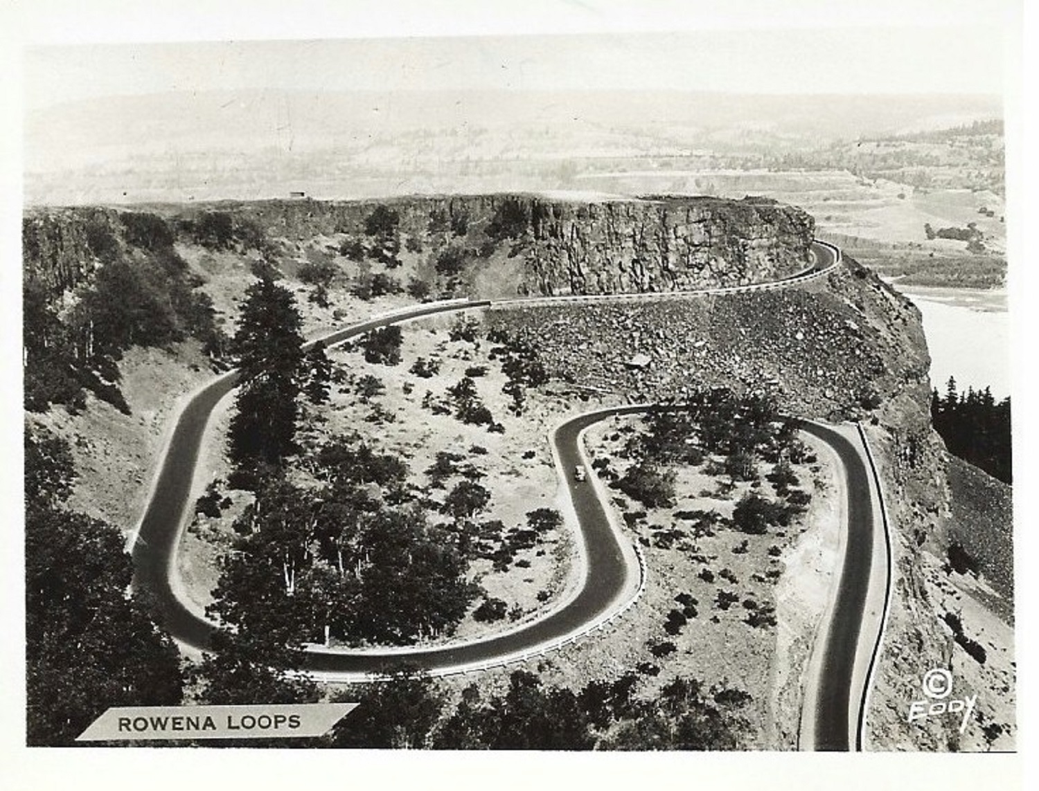
Rowena Loops 1920's
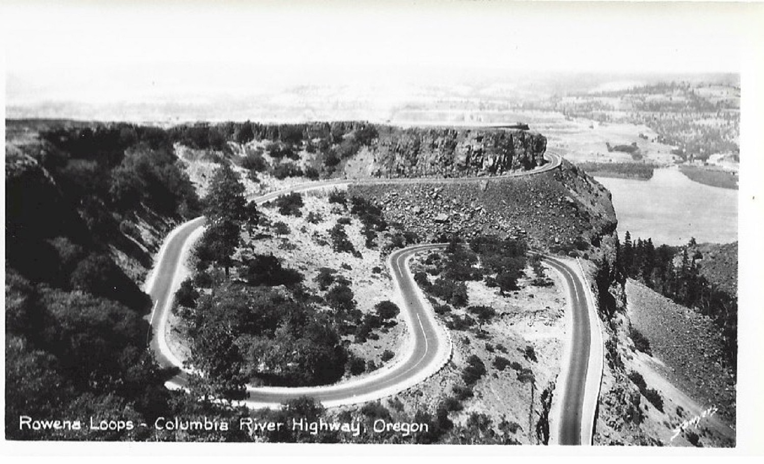
Rowena Loops 1940's
The Columbia River a Photographic Journey
Recreating the Old Oregon Trail Highway