![]()
The Historic Pacific Highway
in Washington
The Lewis River Crossing
![]()
The Historic Pacific Highway
in Washington
The Lewis River Crossing
The Lewis River Crossing
By Curt Cunningham
Davis Ferry
The second obstacle after leaving Fort Vancouver was the Lewis River. The area was known as the “Lewis River Bottoms” and is about 17 miles north of Vancouver. The Lewis River is the largest tributary of the Columbia River west of the Willamette and begins its journey near the foot of Mt. St. Helens and flows westerly toward the Columbia. The Lewis River is formed by 2 branches called the North and East Forks, which unite about 3 miles above its mouth. The North Fork is the largest and is more rapid than the East Fork.
During average and high water, small riverboats
could make it up the North Fork as far as Cedar Creek, which is located about 10 miles above the forks. The
smaller East Fork has an average width of about 100 feet and the head of
navigation is La Center,
which is about 9 miles upstream from the forks. When the river was low, the steamers
could not go up the East Fork and they would stop at Pekin, which was
located opposite of the mouth of the East Fork. Here cargo and passengers
were transferred to flatboats
and scows to be taken
upstream to La Center.
The Chinook People called the Lewis River, the Cathlapotle. In the 1850’s,
the river was named after the first European settler in the
valley, Adolphus Lee
Lewis also known as Aldolphus Le Lewes. Many think the river was named after
Meriwether Lewis of the Lewis and Clarke expedition, though this is not the
case.
Lewis, who was employed by the Hudson’s Bay Company, arrived at Fort Vancouver in 1844.
Lewis was then sent by the company to tend the cattle in the Lewis River
valley.
The company had a contract with the Russian-American Company and supplied
them with beef that was loaded at their crude grain terminal from 1845 to 1850.
This loading facility was located at the mouth of the Cowlitz River where
Monticello will be established. His brother Frederick would join him a
year later.
In 1848, the first ferry cross the Lewis River was established. After 1877, the ferry was operated by Ennels Davis and would become known as the Davis Crossing or Davis Ferry. Later on it would become known as the Pekin ferry, named for an early family that settled east of the crossing near the mouth of the river. Ennels operated the ferry until his death on March 27, 1888. In the 1850's, the Woodland Ferry was established about 4 miles upstream from the Davis Crossing, and operated under various owners until the Woodland bridge was completed in 1913.
In 1850, Columbia Lancaster arrived at the bottoms and built a small cabin on the south side of the
Lewis River 1.5 miles from its mouth. The cabin was built along the old
Chinook trail that will become the Military Road. Lancaster who had practiced law back east was appointed Chief Justice of the Oregon Territory within
2 months of his arrival at Oregon City in 1849.
Later he decided to settle on the Lewis River, and built his first small cabin that was located on the eastern edge of the property.
About 1855, he built
an elaborate mansion, which still stands today and is the oldest wood frame building in Clark County.
The structure is a southern colonial style home and was built with the finest materials available. Lancaster
had many parties at the mansion for the residents of the area and also hosted notables such as Chief
Umtux
and Ulysses S. Grant. In 1941, the Plas Newydd Farm, was established at the
Lancaster farm as a private family business and in 1974, the mansion was listed on the National Register of Historic Places.
In 1851, John Lee Lewis, the father of Adolphus and Frederick was the Chief Factor of Fort
Colville. He had sent a steamer up the Lewis River from Fort Vancouver,
which was loaded with goods so his sons could open a trading post. This new post was called “The Oaks” and served the few residents
of the area. Now the settlers of the valley and in the highlands near La
Center, would not need to travel to St. Helens. The post lasted for the about 3 years until the death of Adolphus in 1856.
In 1852, Squire Bozarth settled on the bottoms a few miles north of
"The Oaks" store and started a farm that he called the “Woodland Farm
House.” This was because of the beautiful stand of fir trees found there. On April 29, 1854, the "Lewis River" post office was established next to the trading post
with Jefferson Huff as the postmaster. Over the next 25 years, the post
office on the bottoms would change its postmaster 17 times, with the office
being moved to the residence of whom ever was postmaster at the time. The
"Lewis River" post office was for a time at Lincoln, La Center,
Woodland and Kerns. This makes it a tad confusing. Eventually the Lewis
River post office would reside at La Center in 1873 and the post office on
the bottom was changed to Pekin.
Also in 1852, Jefferson Kinder
arrived and made his home near the mouth of the East Fork and stayed for the rest of his life. Kinder
was the senior member of the Kinder & Hobert General store and was
one of the most respected citizens of La Center. In 1866, the steamer Rescue
while on its route between Monticello and Portland, would make a stop at the
new Kinder & Hobert store which had opened that August. The store was located at
the mouth of the East Fork at a place known as "Kinder Rock." This
was on the north side of the East Fork, just beyond the mouth. The freeway
now runs right through about where the old store and homestead used to be.
During the 1850’s, the only way to reach the Lewis River bottoms, was
either by the Chinook's old trail or by a boat. The largest town near the
bottoms was St. Helens, which happens to be on the other side of the Columbia River.
Before the steamers ran up the
Lewis River, residents of the bottoms who wanted a steamer ride, walked over to
Caples' Landing, which
is located
due west of Woodland on the Columbia River. They would just flag
down the steamer and it would aim its nose into the bank and then pick up
the passengers. In the coming years, steamers
would begin to ply the Lewis River moving passengers and freight as far as
Cedar Creek and La Center.
By 1855, there were 27 donation land claims on both sides of the Lewis River from
its mouth to about 7 miles above present day Woodland. Some of the people
living near Pekin were; William and Louisa Ginder, Gallatin and Nancy
Kinder, and Samuel and Winena Lishan, plus many others. In the 1860's Ennels C. Davis, son
of William Davis and Nancy Kinder, along with his brother, settled on the
south side of the Lewis River Valley near the bend and the branches of the
forks. Their mother had been living on a farm near the
future town of Woodland. Nancy Davis was originally married to Gallatin
Kinder when she first arrived in the Lewis River valley.
In 1861, the Military Road between Fort Vancouver and Fort Steilacoom was
completed, although it was not much more than a glorified trail between
Vancouver and Monticello. Most of the non-military traffic from Portland and
Vancouver used boats to reach Monticello. The mail carriers, local farmers
and residents were the main users of this section of the "Government
Road," as it was called. It would take
almost 50 years before the road between Woodland and Kelso became a decent
route for travelers.
On January 24, 1862, the first attempt to improve the road in this section was made when the Legislature approved to have T. W. Robinson, George W. Hart and John Proebstel, review and relocate the existing Territorial Road from Monticello to Vancouver and then blaze a route eastward to the Upper Cascades.
Also in 1862, the Lewis River post
office and the area surrounding the bottom lands started to become known as Pekin. The old trail was
now beginning to transform
from a trail into a wagon road. The village of Pekin now had a store,
post office, blacksmith shop, and boarding house. Later a wharf was built so
steamers and flatboats could dock. All the structures were built on stilts
and the town was susceptible to floods. This would be the reason that
Woodland ended up becoming the commercial center of the bottoms as it sits
on higher ground.
On January 24, 1863, the Legislature approved funds for the location and
construction of a
Territorial Road from where the V & S Military Road intersects the
county road at Grand Mound Prairie
and then push it south along the old Hudson's Bay trail to intersect the Military Road at
the Lewis River in Clark county. This was the first major improvement made to the
old trail on the eastern banks of the Cowlitz River that would eventually
evolve into the Pacific Highway.
By the mid to late 1860's, steamers were plying the Lewis River regularly. Passengers and cargo mostly used the steamers for travel and every hamlet along the river had a landing. On April 28, 1866, William S. Martin II, of Martin's Bluff wrote in to the Vancouver newspaper to discuss the condition of the road between the Lewis River and Monticello. He had said the road had been worked very little if any and is impassible except as a mere trail. He then said that; "Steamboat men have been allowed to monopolize the travel and business of the country. The privilege of traveling by steamboat is very nice when you want to, but to be forced to go every time one wants to go 10 miles from home is not so pleasant."
"The time has come when our principal points should be connected by roads, and roads that people can actually travel on. We are not well posted as to the advantages or disadvantages of this line of road, between Lewis
River and Monticello, or the feasibility of the connection at
Lewis River with the different roads leading from Lewis River to Vancouver, but the importance of a good road from this place to Monticello is obvious, and the duty of the highway supervisor."
In 1869, the Military Road between Centralia and Vancouver was improved
again and a new road was built between Vancouver and the Davis Crossing.
This new road on the south side of the Lewis River, continued south on what is now called NW
Lancaster Rd. as it then becomes NW 71st Avenue for a little over 2 miles to NW
291st Street. Here it turned right and followed 291st into Ridgefield.
At Ridgefield, the new road continued south onto NW Hillhurst Road and
continued in a SE direction to meet at today's intersection of NE 10th
Ave. and NE 179th Street. From here the route continued south over Salmon Creek into Vancouver. This new road eliminated the
soggy bottom road that ran along the
river.
In 1873, Captain E. C. Lakin of the Maria Wilkens, made daily trips between St. Helen's and Portland. She disembarked St. Helens at 6am, and sailed from Portland at 2:30pm; making the round trip on the Columbia River side on Tuesdays and Fridays; running through the Slough on Mondays, Wednesdays, Thursdays and Saturdays and calling in at the Lewis River on Tuesdays and Thursdays. In Portland she was boarded at the foot of Morrison Street.
On August 9, 1874, women's suffragette advocate Abigail Scott Duniway, paid a visit to La Center for a lecture and stopped at Pekin while they were traveling up the Lewis River. She wrote about her journey in the The New Northwest; "Pekin, classic Pekin of which we had often heard, loomed up at last, hard by the prow of our faithful boat. A gang plank, at an angle of 45 degrees, was placed on the bank, which we climbed, to find our self in the heart of the city, a thriving retail variety store, where Messer's. Woods and Caples, merchants, who understand their business, are enabled to furnish anything in their line which you may call for, from an elephant to a fine tooth comb."
On January 10, 1876, Pekin was visited by a celebrated exponent of Spiritualism, Professor Jacobs, who gave séances at the residence of Mr. Morris. Miracles, and wonders were "worked and wrought" before the eyes of the astonished audience. Admittance was $1 per evening. It was rumored, only rumored mind you, that a certain prominent gentleman of that vicinity made a trade with the Professor under the hallucination where the Professor, ended up with 40 acres of land. They both went away together, but the Pekinite alone returned, with chagrin and disappointment stamped upon his features. Whatever became of the Professor, the disheartened Pekinite said not a word.
In January of 1876, James Woods and John Caples who operated a general store at Pekin, were having a steamer built for the Lewis River trade. The Hydra as it was called, had it's hull built at St. Helens and then she was launched and towed to Pekin where she was finished. Captain Weir of La Center was the Captain. The Hydra was completed the summer of 1876, and she made a run between La Center and St, Helens to connect with the Portland boats there. Caleb "Uncle Caleb" Woods was father to James Woods and Governor George Woods of Utah.
In the August 26, 1876 issue of the Vancouver Independent, a writer explains where Pekin was in the early days; "Perhaps it would be well before proceeding further to explain to the general reader where Pekin is. Many years ago the good people residing on the North Fork of the Lewis River had a post office established on said river, probably six or eight miles above the present place of receiving and disbursing mail to settlers."
"The office was called Pekin. In due course of time the Postmaster grew weary of office burdens and surrendered the office to someone living farther down the river. The subsequent changes were but repetitions of the first until the office is now on the north side of the river about three-fourths of a mile below the junction of the North and East Forks, while Pekin is all around here, up the river eight or ten miles above the mouth and across the Columbia River. Lying nearest to James Woods, brother of ex-Governor Woods of Oregon. Adjoining is the property of Allen Gilson."
In 1879, the wagon road from Vancouver to Salmon Creek had been extended north along what is now NE 10th Ave to Pioneer, and then continued in a NW direction to West Pioneer. Here the road forked. The left fork continued down the hill to the Pekin Ferry and the right fork ran down La Center Hill into La Center. By the early 1880's more people had settled in the area between Salmon Creek and the Lewis River. The original roads were then moved along the property lines and the famous elbow joints began to appear.
On November 1, 1882, George W. Maxwell decided to call it quits and handed over the running of the Pekin store to Lawrence Maxwell, his son who was learning the business from his father. The village of Pekin, which was not much more than a house on stilts next to a dock, flooded every June, and because of this frequent flooding, the commercial interests began moving to Woodland, which is on higher ground.
Woodland would soon after become the center of activity and the bottom land started to become known as "Woodland." The Pekin wharf continued to be used as a transfer point for the steamers when the forks of the river were too low for the larger steamers to make it upstream Woodland and La Center.
The Pekin ferry continued to operate until the 1920's and the wharf would continue to be used as a transfer point until 1917, when the forks were dredged.
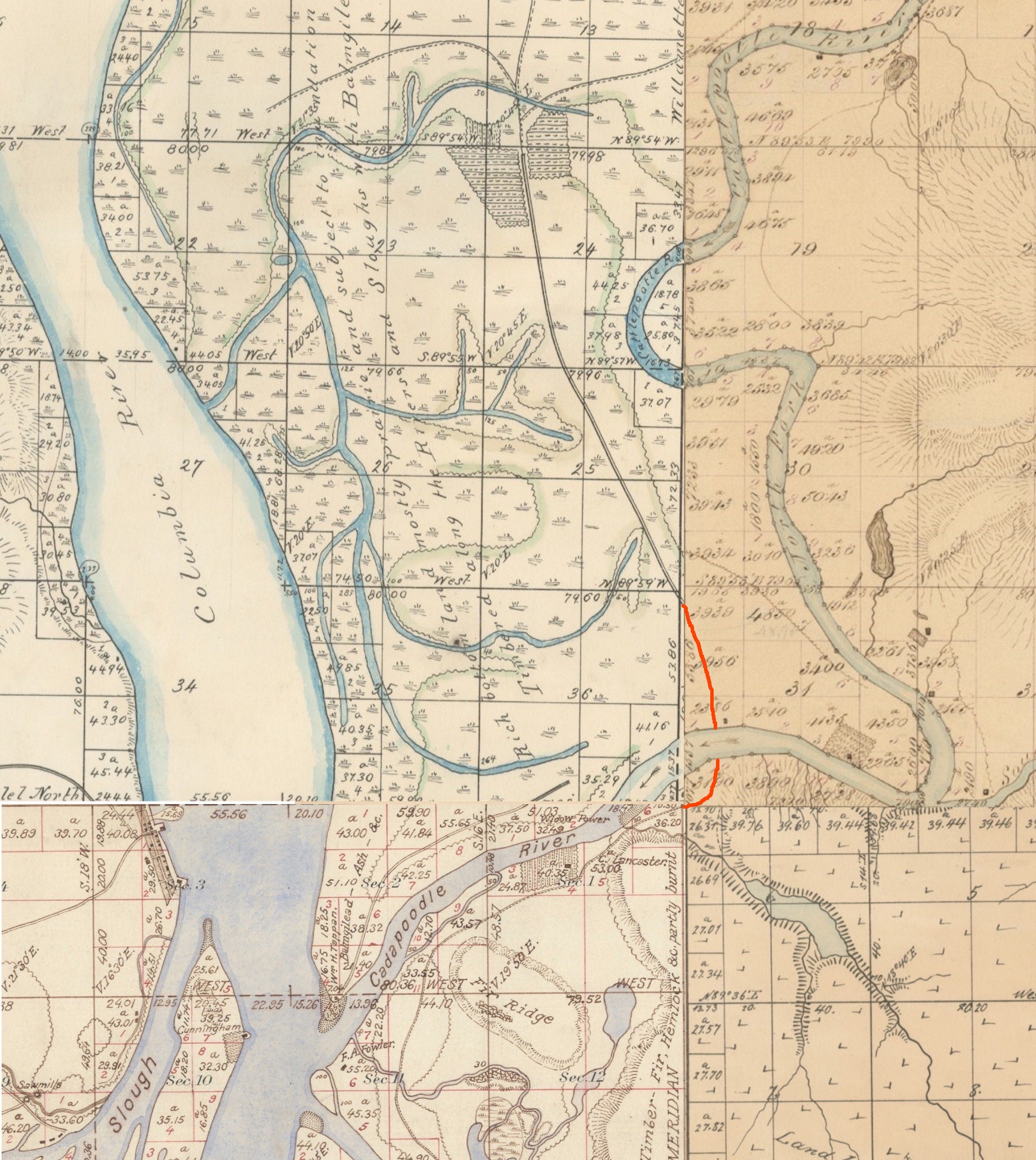
1854 map 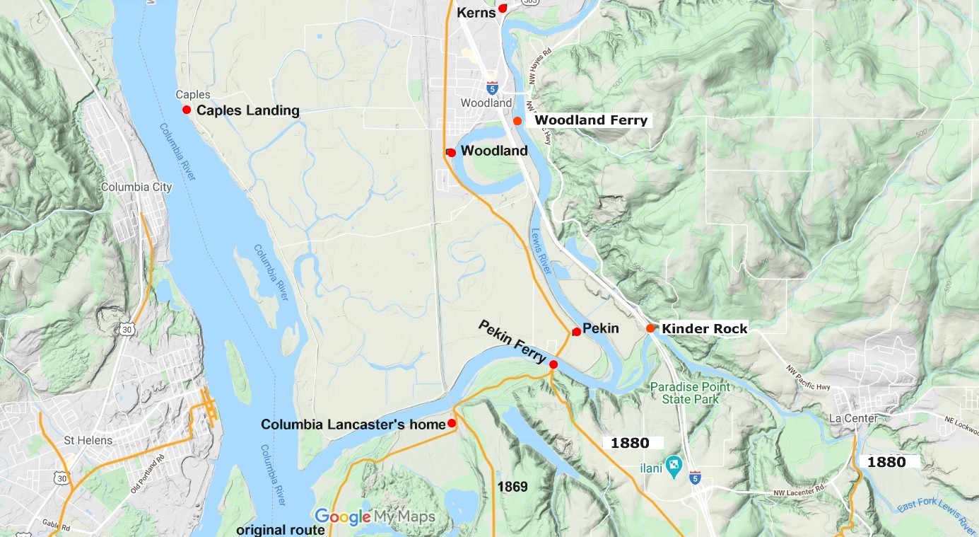
2020 map 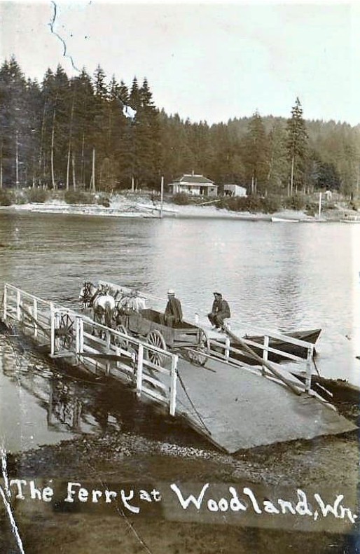
Photo courtesy Washington Rural Heritage Pekin ferry looking south. 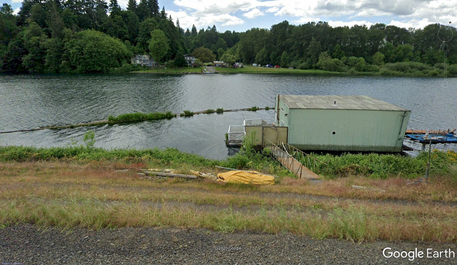
Pekin ferry today looking south. |