![]()
The Historic Pacific Highway
in Washington
The Newaukum River Crossing
![]()
The Historic Pacific Highway
in Washington
The Newaukum River Crossing
The Newaukum River
Crossing
By Curt Cunningham
The Newaukum River
The Newaukum river is a tributary of the Chehalis river, and has 3 branches; the North Fork, the South Fork, and the Middle Fork. All 3 branches of the river converge near the Pacific Highway at the village of Forest on the northeastern side of the Newaukum prairie.
The North Fork begins in the mountains about 16 miles northeast of the Newaukum prairie. The Middle Fork begins a few miles northwest of Alpha and flows west for about 10 miles and empties into the North Fork about a mile east of Forest. The South Fork begins just west of Alpha and flows westerly for about 12 miles following SR-508 toward the freeway, and converges with the North Fork at Forest. The combined river branches then flow northwest for about more 7 miles before it empties into the Chehalis river opposite Alexander park, which located about a mile southwest of Chehalis.
The Newaukum river lies almost below the line of heavy snow. Its water is supplied by the gentle and frequent winter rains on the mountain ranges, where the dense vegetation prevent the water from reaching the river very rapidly making violent floods virtually unknown.
The Origin of Newaukum
The name Newaukum is a variation of the Upper Chehalis word "náwaqwəm." Other variations of the word are Neviakum, Neiviacum, Newaucum, and Newacum. In the book Native American Placenames of the United States by William Bright printed in 2007, he says the word supposedly means "big prairie." Another meaning of the word which is more likely the correct one is found in the book Origin of Washington Geographic Names by Edmond Meany printed in 1923 has this entry; "In the Seattle Intelligencer on September 30, 1872, said that; "General Tilton, of the Northern Pacific Railroad, has been engaged for a few weeks past in laying off the new railroad town of Newaukum, which in the Indian vernacular means, 'gently flowing waters'."
The Newaukum Prairie
The Newaukum prairie is about 4,000 acres of rich agricultural land and is located in the valley below Napavine at the west end, and the village of Forest at the east end. It is also between the main channel of the Newaukum river on the north and SR-508 at the south. The area originally consisted of dense undergrowth as explained in the next paragraph. When the emigrants started to appear in the 1850's, they cleared off the land, little by little and sown it to grass. This enabled the settler to keep a cow. He would then clear a few acres for his garden and meadow, and soon the farmer was a producer. The prairie today is home to many farms that produce a wide variety of produce. In 1871 a visitor traveling through on their way to Olympia said the following; "Occasionally, where there is a small piece of valley land, it is of the richest description. The grass that is being cut in some of these little valleys is the heaviest we ever saw."
On June 29, 1877 a writer described the Newaukum valley; "The best land for cultivation is river bottom land, all of which requires clearing. The growth upon this kind of land consists principally of soft maple, vine maple, ash, and alder, with the occasional cedar or fir. In fact on some lands the fir and cedar are considerable. The Newaukum river which meanders through quite a portion of this county, although quite a stream in winter, never damages by overflow. There are occasional streams flowing into the Newaukum river addling to the convenience if not the fertility of the lands through which they pass. To delineate more clearly the general appearance of the country is generally speaking, heavily timbered. The best lands are owned either by residents, who always welcome new comers, or by speculators who years ago thought of making a good interest on their investment, but who, I can safely say, have bean disappointed and now after having paid taxes on their land for years are offering to sell for $3 to $5 an acre."
The First People
The Newaukum river valley was the territory of the Upper Chehalis tribe. The Satsop river is considered the division point between the Upper and Lower Chehalis tribes. Some ethnologists maintained that the Satsops were a subdivision of the Lower Chehalis. This was because they were part of the same political group. The Satsop language, however, was a Kwaiailk dialect. The Quiyaisk or Kwaiailk are one of the 4 known bands of Upper Chehalis that lived along the Chehalis river.
They had villages as far west as the Satsop river and upstream as far as Boistfort. The village of Aqaygt was located along the river at Grand Mound and the village of Tewtn was about 3 miles above the mouth of the Skookumchuck. Cloquallum was another village located on the river of the same name. They also inhabited parts of the Upper Cowlitz river. The area at the confluence of the Chehalis and Skookumchuck was called "Tasunshun," which means "resting place." The Chehalis river was known as the "Nisoolups."
Fish were harvested from the Cowlitz, Upper Chehalis, Newaukum, Skookumchuck, Black, and Satsop rivers. They hunted in the mountains, and across the many prairies in the Chehalis valley. At the mouth of the Skookumchuck, the Upper Chehalis had a camp there and, for a small fee, would ferry people across the river who were traveling along the Cowlitz trail. In 1855, according to George Gibbs, there were 216 Upper Chehalis, but by that time they were becoming amalgamated with the Cowlitz. Today most are part of the Cowlitz Tribe, though some belong to the Confederated Tribes of the Chehalis Reservation.
The First European Settlers
In 1844, Marcel Bernier, a French-Canadian who emigrated from the Red River District in Canada, started a farm near the Newaukum river and near the future village of Forest. Marcel was the son of Julien and Marguerite Bernier. His father, Julien, born about 1794, was the son of Jean-Baptise Bernier and Marie Landry. Julien was first employed by the North West Company in 1811 or 1812 when he was about 18 years old.
In 1813 Julien was a member of the party that took over Fort Astoria from Astor's Pacific Fur Company. While he was at the Spokane House, Julien met Marguerite, who may or may not have been an Indian. They were married there prior to the birth of Marcellus on November 10, 1819. The Spokane House was an early trading post located on the Spokane river near Nine Mile Falls. His brother Isadore was born at Spokane House in 1827.
In 1830, the Bernier family moved to the Red River settlement which was located at the mouth of the Assiniboine river in Winnipeg, Canada. This was so Marcel could attend the St. Boniface school that was located there. In 1841, Marcel left home for Fort Nisqually. This was a few months before the 23 families of the settlement including Bernier's parents traveled to Puget Sound. These settlers were promised by the Hudson's Bay Company (HBC), land and supplies if they would settle near Fort Nisqually. When these weary travelers arrived, the HBC reneged on their offer. Marcel and his father, along with their families, traveled to the Cowlitz Farm and settled there. They were one of the few families that stayed north of the Columbia river despite the HBC going back on their offer. The families that did stay were helped out a little by the company.
In 1842 Marcel traveled to Whidbey island on a missionary tour and helped build a log church there. After returning to the Cowlitz prairie in 1844, Marcel married Cecelia Bercier, who was the daughter of HBC employee Pierre Bercier. At the request of Dr. William Fraser Tolmie, Chief Factor of Fort Nisqually, Bernier established a private farm on the Newaukum prairie where he grew wheat that he sold to the Puget Sound Agricultural Company (PSAC). The PSAC was a subsidiary of the HBC.
During the late 1830's and early 1840's, the Hudson's Bay Company was trying to get as many British subjects to settle north of the Columbia as they could. This was to help bolster their presence in the region to substantiate their claim to the territory north of the Columbia when the time came to settle the boundary question with the Americans.
Listed on the 1847 tax roll that was taken by John R. Jackson, shows Julian Bernier, Isadore Bernier and Marcel Bernier all living in the area. In 1869 Isadore was running a stage line between the Cowlitz Landing and Olympia. Marcel had a son named Julien who was born in 1843 and had purchased 160 acres near Mary's Corner in the spring of 1876, and lived there until his death in 1912. Peter Bernier, who had purchased 80 acres north of Marcel in the summer of 1878, was either Isadore's son or Marcel's son. In February of 1924, Napoleon J. Bernier received a land patent for .45 acres on the east side of the Newaukum river at Forest.
Marcel Bernier became an American citizen in 1849, and in 1851, he was a signer at the Cowlitz Convention. His father Julien, arrived at the Newaukum valley from the Cowlitz prairie sometime between 1850 and 1855, and took a claim just north of Marcel. Julien and Marcel filed their donation land claims on November 11, 1866. Julian died on his farm June 8th or 17th of 1871. Marcel continued to live on his farm and was the blacksmith and wagon maker at Napavine. He continued in this profession until rheumatism crippled him so that he could not work anymore. Some three weeks before his death he was injured by his horse who suddenly took off running, throwing him from his buggy. Marcel passed away at his home on December 27, 1889 and is buried in the cemetery at the Cowlitz Mission.
Sometime between 1850 and 1852, John and Mary Ann Moore arrived from Iowa and started a farm northwest of Julien Bernier. John was born in Pennsylvania and in 1840 married Mary Ann in Iowa where they lived until they crossed the Oregon Trail. The Moore's owned 640 acres in the Newaukum valley. Their children were; Charles, Mary Elizabeth, Richard, William J., James O., Robert and Perry. Their daughter, Mary Elizabeth Moore married Sydney S. Ford, Jr. on October, 21 1860. There are documents that say John Moore's home at Newaukum prairie served as the Lewis county courthouse for several sessions. There is one formal record of a court session held on December 1, 1858 at John Moore's home.
John Moore may have passed away sometime in 1871. As on November 18, 1871 Mary Ann Moore began to place adds in the newspapers selling the 320 acre donation claim of John Moore, deceased. The property had one mile of river frontage adjoining the Newaukum prairie.
In 1851 George Barber Roberts retired from the HBC and moved from the Cowlitz Farm to the Newaukum prairie where he took a 320 acre donation land claim next to Marcel and Julien Bernier. Later he would purchase another 160 acres. Some of his property was on the south side of Marcel and another parcel was in-between Marcel and Julien.
George Roberts was born in England in 1815, and in 1826 at age 11, young George went to the Greenwich Royal Naval School. This was a school for children of fathers who had died in service to their country. When he was 14 years old he was given a 7 year apprenticeship with the Hudson's Bay Company at Fort Astoria. He departed England on the ship Ganymede and arrived in Astoria on May, 15 1831. In February 1832, he was sent to Fort Vancouver to assist James Douglas as a clerk.
In 1834, he spent a year teaching school to about 50 children of the company's employees, and a year later he resumed employment as a clerk. He served until 1843, when he returned to England. While there, he fell in love and married Martha Cable. In December 1843 they left England and sailed for Fort Vancouver, arriving in May 1844. Not long after his arrival at the fort, Roberts was sent north to manage the Cowlitz Farm. George and Martha had three children; a son and 2 daughters. Sadly, in 1850, Martha and the girls died of typhoid fever. A year later in 1851, Roberts and his son, George junior, left the Cowlitz Farm and moved north to the Newaukum river, He would be a signer at the Monticello Convention.
Sometime during the early 1850's, the now widowed Roberts met Rose Birnie, who was the sister of James Birnie of Cathlamet. They were married at Cathlamet on May 8, 1855. In 1858 Roberts moved back to the Cowlitz Farm to manage it until the land claims of the HBC were settled with the Americans. In 1871, the Roberts' left the Cowlitz Farm and moved to Cathlamet to be closer to Rose's family. While living in Cathlamet, he operated a store, and served as; probate judge, treasurer and auditor. Rose became the first known school teacher in the Cathlamet community.
The Cowlitz Trail
The Cowlitz Trail ran through the Newaukum prairie between Mary's Corner and Bishop Road about a quarter mile west of the Pacific Highway. Roberts Road may be on the original trail. George Roberts' home was located at the intersection of the Cowlitz Trail and the foot trail leading to Cutting's prairie (Napavine). This would put his home today at the intersection of Roberts Road and SR-508.
The Newaukum river could be forded at the crossing, though if the water was too high, you and your horse would have to swim across. On December 5, 1853 John Moore established a ferry at the Newaukum crossing. He operated this ferry until the bridge was built in 1857. The Moore ferry was located somewhere near the east side of the Newaukum golf course.
The trail between Fort Nisqually and the Cowlitz Farm was first improved between the Tenalquot prairie and the Grand Mound prairie in 1849 when Dr. Tolmie sent some employees to clear the road for their ox carts. These 2 wheeled carts hauled in the produce grown on the farms. On April 23, 1849, Dr. Tolmie sent Walter Ross, Jacob, and some Indian employees to clear the road between the Tenalquot and the Grand Prairie. On Saturday, April 28, 1849, the road crews returned to Fort Nisqually and reported to Dr. Tolmie that the old trail between the Tenalquot and the Grand Prairie was now passable for the carts. This section of the road was through dense forests that had to be cleared of the downed trees each year. The road through the prairies needed very little work to keep a path open.
In the PSAC's Nisqually Journal of Occurrences written by Dr. Tolmie contains the following notations; "Thursday October 25, 1849, Heavy showers during the night. Mild Sunshine. Had a letter from Cowlitz today, which was conveyed as far as Tenalquot by Lapoitrie who along with some Indians is transporting wheat from Newaukum prairie to Tenalquot and has made one trip without accident. Wednesday October 31, 1849, Showery. In the evening William Ogden nephew of Peter Skene Ogden arrived at Fort Nisqually accompanied by Charles McKay of the Tualatin settlement in Oregon and Marcel Bernier of Newaukum. Thursday November 8, 1849, rainy. Lapoitrie with his Indians, retired having in three weeks made the trips with wheat from Cowlitz & Newaukum to Tenalquot."
In 1850 HBC Employee Edward Huggins wrote about a trip from Fort Nisqually to the Cowlitz Farm. This is what he said as he passed through the Newaukum prairie; "Two or three years after my trip across the bottom the worst of the mud holes were corduroyed, which at high stages of water would be floated out of place and the road would then be worse than ever. I proceeded, and in a short time got into a fine, rather large prairie, upon which was a good deal of the usual zig-zag fencing and two or three houses. The first place was the home of an old Canadian (Bernier), and at the far end of the prairie was the well known farm of John R. Jackson, who owns a full section of what looked to be the finest kind of land."
On February 2, 1857, the government placed ads for bids to construct a military road from the Cowlitz Landing to Ford's Prairie on the Skookum Chuck. The roadway was to be 25 feet wide with all stumps and roots removed within 12 feet. Corduroy (split log planking) was used on the low and marshy ground between the Skookum Chuck and the Newaukum. The first section constructed, was 15 miles from the Cowlitz Landing to the Newaukum river, where a bridge was built. The second section was 12 miles between the Newaukum river bridge and the Skookumchuck river bridge. This is when Moore's ferry went out of business and was most likely when the road between Mary's Corner and Bishop Road was moved east to its current alignment through Forest on the Pacific Highway.
The Early Post Offices of the Newaukum Valley
In 1852 Lewis and Rachel Johnson arrived in the Newaukum valley and took a donation claim southwest of the old schoolhouse (Chehalis Middle School) and east of the freeway at Dillenbaugh creek. On December 19, 1856, Johnson became the first postmaster of Newaukum Prairie that served the farmers with weekly mail on the route between the Cowlitz Landing, and the Skookumchuck.
In 1862 John Moore took over as postmaster of Newaukum Prairie and the office was moved to his home near the Newaukum river crossing. The Newaukum Prairie post office was discontinued on March 25, 1863.
In 1872 shortly after the railroad built the depot at the bottom of Napavine hill in their new town called Newaukum, a post office was established. Taylor Rue was appointed postmaster. When Rue first arrived in the Territory, he had first settled at Monticello, and then later moved to Newaukum. His daughter, Annie Rue, married Hiram C. Shorey in 1875.
In 1874 Hiram Shorey became the postmaster of Newaukum after he and his partner Lute Davis opened the general store. On June 21, 1879 his wife Annie Shorey was appointed postmaster for Newaukum. The Newaukum post office would be discontinued on January 1, 1907.
In April of 1876 a post office was established on the road between Chehalis and the Cowlitz Landing also called Newaukum Prairie. This office appeared in the newspapers between April and August of 1876 and again in September of 1877. This is all I can find at the moment on this mysterious post.
On December 14, 1896, Amanda Munroe, who was the owner of the store at Forest, established the Forest post office inside the store, and Amanda became its first postmaster. Joseph Greuner was postmaster in 1902 and also ran the mail between Chehalis and Forest. The Forest post office lasted 38 years and was discontinued on March 31, 1934.
The Railroad Town Called Newaukum
In 1872 General John W. Sprague who was now superintendent of the Northern Pacific, planned to build a town and a station at Chehalis then known as Saundersville. Eliza (Saunders) Barrett owned some of the land that Sprague wanted and she was not in any hurry to sell. Eliza had large real estate holdings and had been taken advantage of by some shady characters. The railroad did not have a good reputation with the public, which did not help matters. She told Sprague to pound sand and would not sell to him.
The General withdrew his offer to build a station at Saundersville and then purchased some land a few miles south at the bottom of Napavine hill. Sprague then had General Tilton lay out the Town of Newaukum on August 9, 1872. Newaukum is located 2.5 miles south of Chehalis. The railroad built a depot, water tank and a side track. They then placed ads offering lots for sale. In 1874 Hiram Shorey and his partner Lute Davis, constructed a building and opened a small store in the new town. Shorey would also become a sheriff of Lewis County.
Claquato at this time was the county seat and the settlers started a petition to move the county offices to a point where the Newaukum and Chehalis rivers joined. The railroad had previously offered a free site at its new town and agreed to erect a $4,000 courthouse. The people vehemently refused to consider this and decided to move the county seat to Saundersville. The people of Saundersville had objected to Newaukum because at the time the only way to get there was to walk the rails or take the Military road from Claquato that ran up and over a steep hill to reach the town.
On April 26, 1873 The Beacon reported that a petition was numerously signed and was presented to the Northern Pacific asking that the depot at Newaukum be moved to Judge McFadden's farm in Saunders' Bottom. This they denied and the residents had to continue to walk the rails for 2 miles to catch the train. Because of the dispute with Eliza, the Northern Pacific refused to build a depot or make a flag stop at Saundersville.
On April 4, 1874 Newaukum was described as a promising place. The town had a telegraph and post office, daily mail, etc. The store was operated by bachelors Davis and Shorey. They were both building new residences, said to be indicative of happy coming events. The grist mill at the confluence of the Newaukum and Chehalis was starting up the following week with a capital stock of $25,000. The company sold $10,000 worth of the stock the first week.
Today the town of Newaukum and at depot no longer remain, although the area continues to be a thriving community of farms and residences.
The Newaukum Burglary
On August 30, 1889, two suspects who gave the names of T. F. Martin and John Murphy, were caught stealing from residents who were living in the Newaukum and Chehalis valley. On August 21st, they robbed a trunk at Newaukum of two suits of clothes, a pistol, locket and other minor articles. Afterwards they went through several houses in Chehalis, stealing some money, clothing and other stuff, capping their exploit by stealing a sample case of hardware belonging to a drummer named Almos who was traveling for Foster & Robertson, of Portland.
The sheriff and constable had them under suspicion for some time, and as they hung around, kept a close eye on them. Saturday the 24th, Constable Burnett found they were trying to trade a revolver to a young man in Chehalis, who was instructed to lead them on. On Monday the 26th, the young man reported the trade was ready, and the officers quickly appeared and arrested the duo. A quantity of stolen stuff was found on them, among which was the pistol stolen at Newaukum plus the new revolver and some cutlery belonging to the drummer. The following day the constable found the sample case, which contained about a hundredweight of cutlery. A few days later he found another cache of stolen plunder in the woods.
The Narrow Escape
On August 17, 1897 a young lady who lived near Newaukum, was walking on the railroad track toward Chehalis that afternoon. She had a very narrow escape from death under the wheels of a Northern Pacific passenger train. She was walking on the long trestle over the Newaukum river when the train came barreling down on her after descending Napavine hill. When she heard the train coming she started to run for her life, hoping to reach the end of the trestle before the train killed her.
She did her best to outrun the train but, after running a short distance, she tripped and fell onto the tracks. As soon as the engineer saw her he slammed on the brakes. When the train came to a standstill, the nose of the cowcatcher just touched her prostrate body. When she was picked up off the tracks she brushed off her knees and went on her way unharmed, except for a few minor scratches. When the train got under way the passengers held a meeting and passed a resolution commending Engineer Jones warmly for the coolness and promptness that saved the life of the young girl.
The Chehalis-Newaukum Plank Road
The road between Chehalis and Toledo had been a pain for travelers since the 1840's. By the 1890's the worst places on the road were planked and this lasted until 1913 when the plank road was replaced with fill and a gravel road, which would allow the concrete paving to begin.
On February 5, 1890 the heavy rainfall caused the Chehalis and Newaukum rivers to overflow. The rivers were the highest that anybody could remember. The constant rains had turned the roads into mud bogs making them impassible, except where they had been planked. The residents said that if the Legislature would adjourn for a week's trip over the country roads they would stop their fooling long enough to devise and pass some road laws so more plank roads could be built.
During February of 1891 the first mile of planking was laid through McFadden's addition in Chehalis south toward the Newaukum valley. On December 24, 1893, a decision was made to extend the Chehalis-Newaukum plank road from the Newaukum river to the Jackson Prairie and the Cowlitz. The completed project gave Chehalis a connection all the year around to the largest portion of the agricultural territory in Lewis county. Many merchants had expressed their willingness to assist in the construction. The improvement of the roads in Lewis county had gone steadily forward that Fall and Winter and was completed in spring of 1894. In the places on the road that were not planked, they would be improved with gravel surfacing.
Edward Huggins trip through the Newaukum valley in 1850
The Pacific Highway through the Newaukum valley
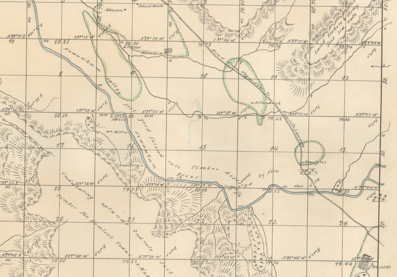
1857 Survey map showing Moore's Ferry.

1857 survey map showing the trail leading from Roberts home to Mac Donald's station.
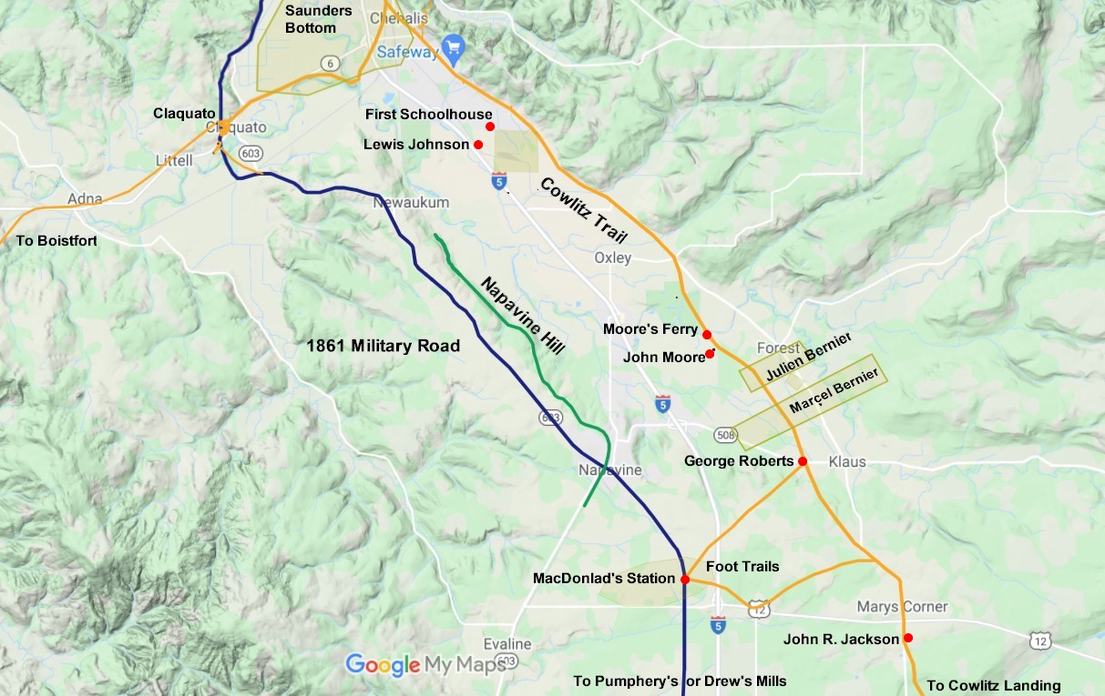
2021 map 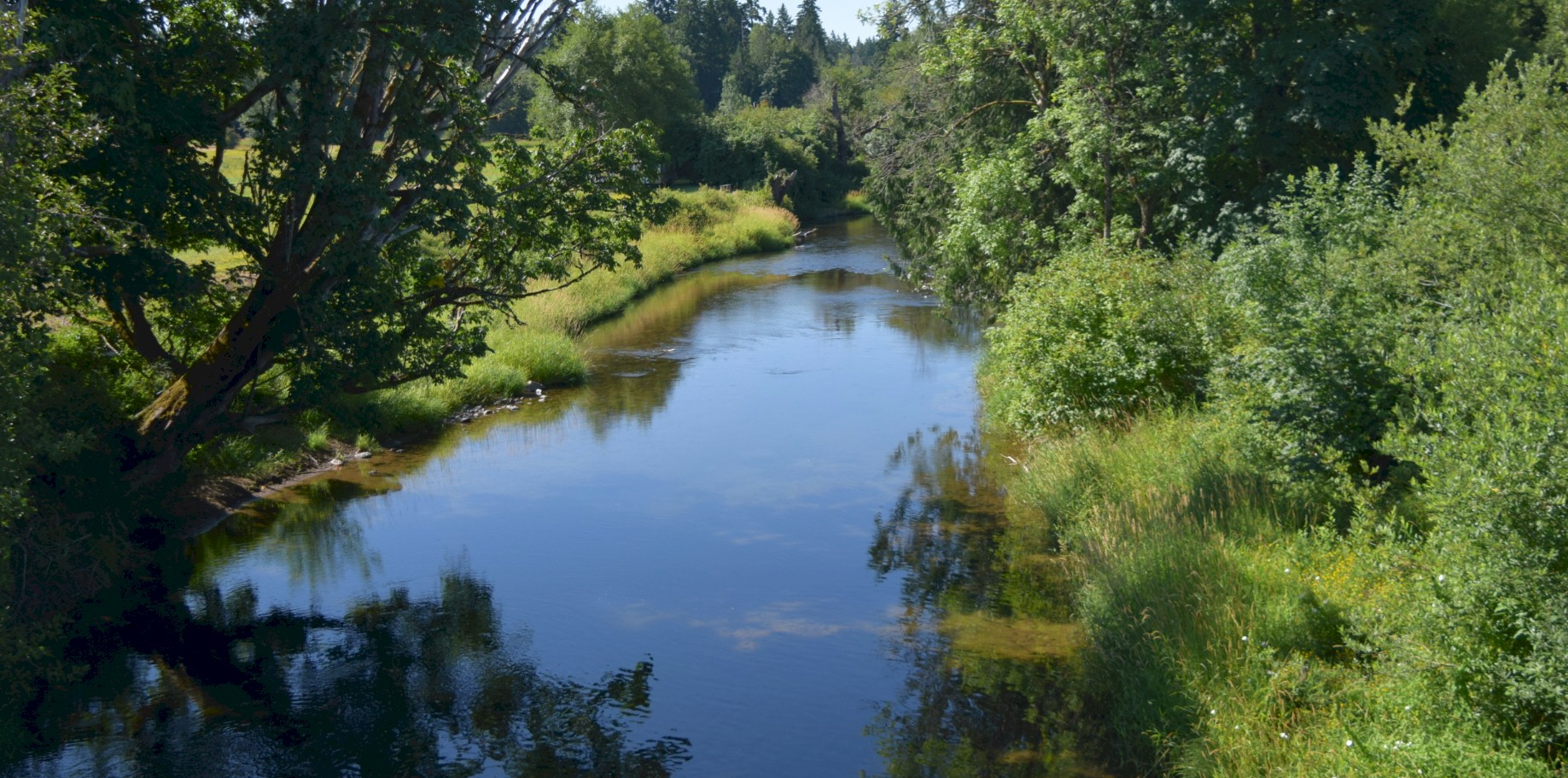
Newaukum River, looking west from the Pacific Highway bridge. 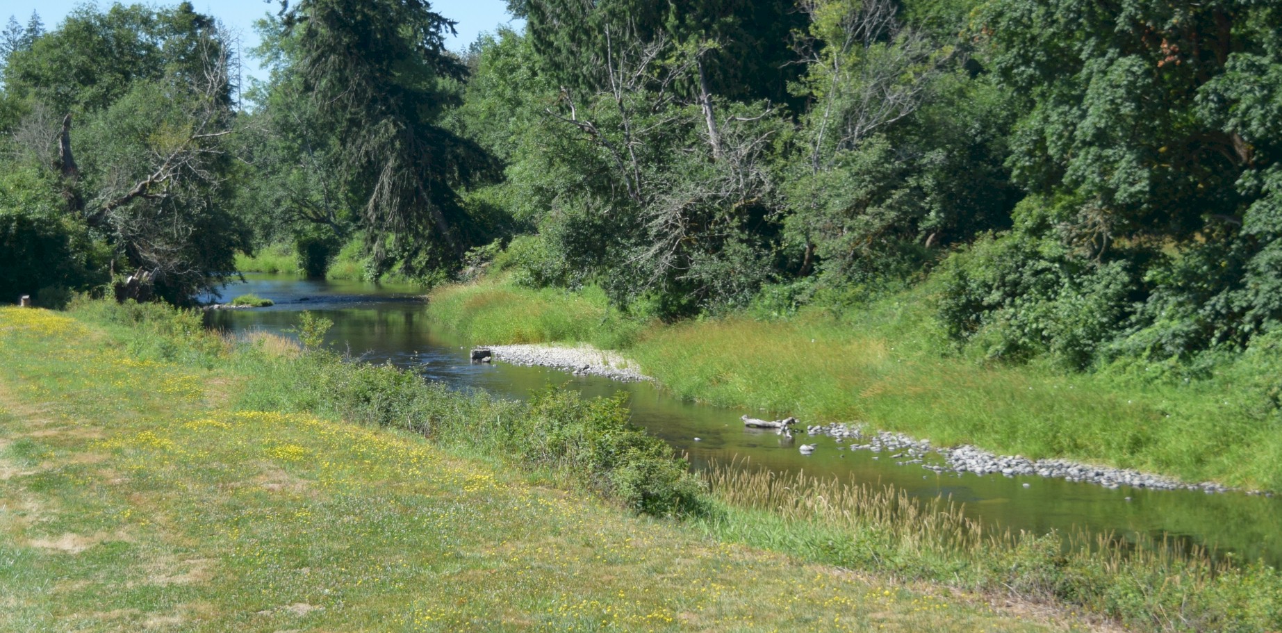
Late July, 2021 the Newaukum River, looking northwest from the Pacific Highway. The river looks low enough to ford. 
Newaukum River looking west from the Pacific Highway bridge. |