![]()
The Historic Pacific Highway
in Washington
Newaukum
![]()
The Historic Pacific Highway
in Washington
Newaukum
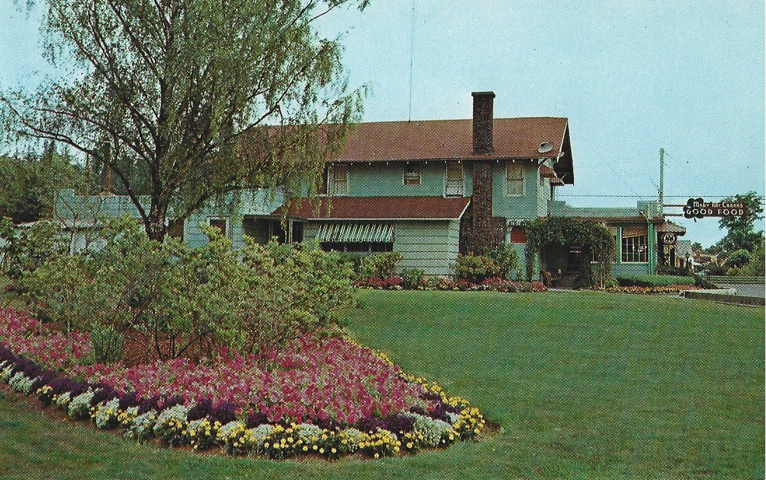
Mary McCrank's Roadside Diner
In 1935 Mary McCrank purchased the Dutch Mill Tavern which is 4 miles south of Chehalis on the Pacific Highway. She converted the tavern into a diner and called it the Shamrock Inn. Later the place would become known as Mary McCrank's. Mary passed away in 1984 and the diner continued until 1998 when it was purchased by Gerhard and Jeri Schopp. In 2012 they changed the name of the diner to Schopp’s Steakhouse which lasted just one year before closing down. In 2015 Shelly and John McKerricher purchased the property and converted the restaurant into a wedding and event center called Creekside Chehalis.
History of Newaukum
By Curt Cunningham
Cowlitz-Olympia Road
By the late 1800's, the Cowlitz Trail had evolved from a foot path to a wagon road although not a very good one. Between Chehalis and Toledo the road through the valley was always muddy most of the year, and impassible during the rainy season. To remedy this problem wood planks 8 feet wide were used in the worst places. The old road through the Newaukum valley then became known as the Chehalis-Newaukum Plank Road. In 1905 when the state highway commission was created, the old road between Olympia and Toledo would become known as the Cowlitz-Olympia Road.
In 1900 Retired Hudson's Bay Company clerk Edward Huggins wrote about a trip he took to the Cowlitz Farm in 1850; "Two or three years after my trip across the bottom, the worst of the mud holes were corduroyed, which at high stages of water would be floated out of place and the road would then be worse than ever."
Before the Pacific Highway was routed through Toledo in August of 1913, the road between Portland and Olympia was through Napavine and Winlock and crossed over the Cowlitz river at Olequa. This was because the road between Chehalis and the ferry at Olequa was in better shape. From Napavine south the road was above the soggy bottoms between Chehalis and Toledo. After State Road No. 5 was established in 1905 work would begin to improve the Cowlitz-Olympia road between Chehalis and Mary's Corner.
Mary's Corner is located just north of the Jackson cabin on the Jackson prairie where US Highway 12 crosses the Pacific Highway, and was named after Mary "Inez" Rogers. Mary, who went by the name Inez, was the daughter of James and Anna Evinger Wood. On June 16, 1908 she married Carl Rogers. During the 1920's Inez ran a store at the intersection of these highways.
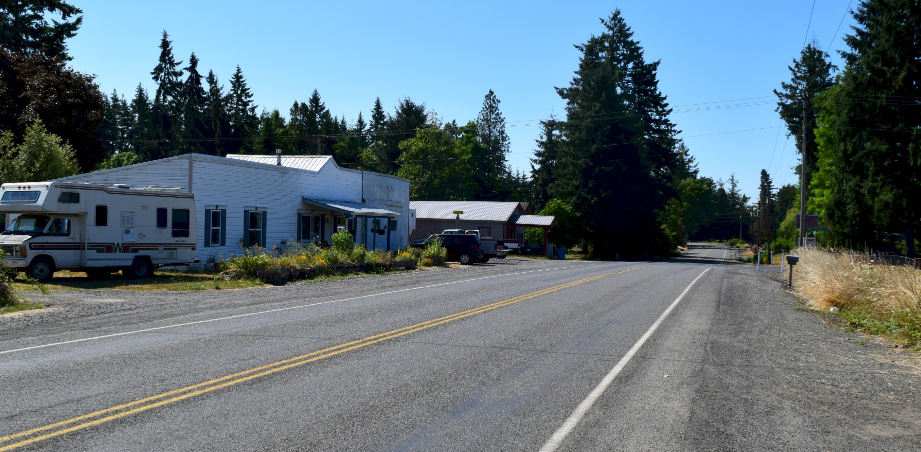
A Village named Forest
Forest is a small community 7 miles southeast of Chehalis on the Pacific Highway, a half mile south of the confluence of the North and South forks of the Newaukum river. It was named after John T. Forrest who was an early schoolteacher.
Julien Bernier's farm was between the Napavine-Forest Road and Vista Road. The Forest store and post office was at the intersection of Vista Road and the Pacific Highway. Across the highway from Vista Road begins the North Fork Road to Alpha and Cinebar.
In the Fall of 1874 the Forest-Napavine road was built. The road is about 2.5 miles long and crossed the valley between the old Military Road and the Pacific Highway. In the 1970's SR-508 was extended to Napavine which severed the Forest-Napavine road and it was realigned to create today's intersection. Julien Bernier's south property line runs along the north side of this old road. This was built so the farmers would have a connection to the depot at Napavine.
On March 30, 1877 Forest resident George Roberts Jr. placed a notice in the newspaper telling people that his wife Laura J. Roberts had left his bed and board without just cause and he herby gave notice to all persons not to credit or trust her on his account.
In the spring and summer of 1899 the Northern Pacific was offering special rate excursions to the Northwest for people interested in settling there. The service was an instant success and the first train brought in Mr. Dean who purchased Julien Bernier's farm for $3,500. Charles Denning who was from Murdock, Nebraska purchased the McClure place on the North Newaukum for $1,800. The newcomers were having a hard time finding houses that were already built, but somehow the proverbial room for one more applied. Most of them had gone to work in the mills and on the farms. Everyone who came found something to do immediately upon their arrival. These new arrivals were the first important influx of Eastern settlers since the return to prosperity after the Panic of 1893.
By 1902, Forest had a general store/post office, a school building, with a teachers cottage, a grange building that was the center of the community, a flour and saw mill that was operated by A. Hylak and his son, and a blacksmith shop that was owned by Joseph Zeutecky. Joseph Greuner owned the store in 1902 and was the postmaster. The last owner of the store was in 1947 when Bob Trodahl purchased the store. Not sure when the store was closed for good.
In 2021, Forest consisted of; the old store building, the Northfork Asphalt Paving Co. and the grange building. The store that was also the post office is now a private residence. The old homestead can be seen on the north end of the store building. The old grange hall continues to be the center of the community.
Cowlitz Pass Highway
In 1905 the Legislature created the Washington State Highway Commission. The new department's first task was to establish 10 state highways. Of these first state roads, there was no North-South trunk highway established between the Puget Sound and the Columbia river.
State Road No. 5, which was the precursor to today's US Highway 12 was one of these first state highways. State Road No. 5 also known as the Cowlitz Pass Highway, was to be a wagon road between Lewis and Yakima counties. The road was to pass through the Klickitat prairie (Mossyrock) and then to the Riffe post office (now under Riffe lake). From there the road was to run past Glenoma, Randle and Packwood. From there it was to cross the divide at Cowlitz pass and then to North Yakima.
The highway department considered this trans-mountain road 3rd in importance to the state, while as a local road its importance could not be overestimated. This road opened up the Big Bottom section of Lewis county, and was supposed to tap into the coal fields near the Cowlitz pass, and give the US Government access to the storage reservoir in Yakima county while giving access to the mining properties of the Gold Hill district, and to open a fine route for summer pleasure travel through the Cascade mountains.
It was a big dream but by the summer of 1906, only 10 miles of the road in Lewis county was completed between a point 3.5 miles west of Salkum on the Cowlitz prairie to Mossyrock. By 1908 just 11.62 miles were completed in Lewis county. At least the farmers on the Big Bottom now had a better road to the depot at Chehalis.
On October 12, 1907 a contract was let for grading of .19 miles in Lewis county on the Cowlitz-Olympia Road. The work was completed in July of 1908. Also in 1907 State Road No. 5 was moved from Cowlitz pass to Carlton pass as it is 700 feet lower and would make the road 6 miles shorter. The road was then routed toward the US reclamation reservoir at Bumping lake to connect with State Road No. 1 east of Chinook pass. This is where the Bumping river meets the Naches river.
State Road No. 5 had originally terminated at Mary's Corner. From there the Cowlitz Olympia Road was used to Chehalis. This hastened improvements of the Cowlitz-Olympia Road in Lewis county. On August 21, 1908 a contract was signed for .34 miles of oiled macadam paving on Road No. 16, Cowlitz-Olympia Road. This work was completed in October of 1909.
In 1909 the county bridge across the Cowlitz river at Mayfield was raised 10 feet and new stringers were installed. The work was completed during September of 1910. By 1910 State Road No. 5 was completed from Chehalis to Snider's ferry over the existing county roads. At the ferry the road forked. The left fork ran north to Morton and the right fork ran east to Glenoma, Randle and Packwood.
On April 3, 1910 a contract was awarded to Barnett Construction Co. for paving of .74 miles of the Cowlitz-Olympia Road with oiled macadam. The grading on this section of the highway was very costly, owing to the large amount of gumbo encountered in the cuts. In places it was necessary to excavate to a depth of two feet below the grade for the entire width of the roadway. In other places it was found necessary to lay porous tile surrounded with broken stone one foot below the subgrade, to secure proper drainage.
The road was bound with a mixture composed of 88% tar, 10% pitch, and 2% resin. The top course was first placed on the road uncoated, and rolled dry. A 90 gallon tar spraying machine was fastened to the back of a roller and connected to the boiler. The roller mixed and heated the materials to a temperature of 200 degrees, pumped the mixture into pipes, and forced it through a fine sprayer onto the surface of the road under steam pressure. The stone was thoroughly coated by the use of about 3/4ths gallon to the square yard, and the road when finished gave evidence of a first class permanent pavement at a low cost.
Under the Permanent Highway Act of 1911, the first concrete paving on the Cowlitz-Olympia Road began in the spring of 1912. In Lewis County, 2.25 miles of the highway leading southeast from Chehalis toward Forest was to be paved. On April 5, 1912, Lewis County passed a resolution to pave another mile of the highway southeast of Chehalis. On August 4, 1912, the contracting firms, Keasal Construction and B. S. Davis of Tacoma were making good progress in paving the road. The grading was almost completed and the mixing on Keasal's portion had begun.
In 1912 the Legislature extended State Road No. 5. The longer highway would begin at Napavine and continue southeast about a mile and then turn eastward on what is now Koontz Road. The old state highway met the Cowlitz-Olympia Road at the top of Jackson hill. Before the hill was re-graded in 1917 for the Pacific Highway, the Cowlitz-Olympia Road ran on what is now Conway Road. The highway then continued east through Mossyrock and Snider's ferry at Riffe.
The state never began construction of a road over Carlton pass. They would not be ready to do so for another 5 years. But as the state was preparing to begin construction, the first world war stopped all work on the project, and it was then indefinitely postponed. All the efforts at road construction were moved to the Pacific Highway. The Army said they needed a good road for west coast troop maneuvers.
It would take almost 40 years for the gap in the highway between Lewis and Yakima counties to be connected. In 1951 the highway project that was postponed was resurrected, but the road was re-routed again over the mountains. This time it was to go over White pass and follow the Tieton river to the Naches river, and then follow that river east to Yakima.
In 1968 the Mossyrock dam was completed. The lake behind the dam known as Riffe lake submerged the old Snider's ferry the town of Riffe and the old Mayfield bridge. The highway between Riffe and Glenoma was also submerged. The highway was then re-routed from Mossyrock to Morton and then east to Glenoma.
The National Park Highway
In 1913 the Legislature established the National Park Highway. This highway utilized the completed portion of State Road No. 5 between Mary's Corner and Snider's ferry at Riffe. From Snider's ferry, the new highway was routed north to Morton and then northwest toward Tacoma. On the western end, at Mary's Corner, the National Park Highway was routed north on the Cowlitz-Olympia Road to Chehalis where it turned west toward Raymond and continued toward the ocean.
This state highway should not be confused with the Park to Park Highway and the National Parks Highway as these were cross-country roads.
The Pacific Highway
In 1913 the Pacific Highway was also established. The Legislature only designated certain towns along the proposed route, and did not actually say which county roads it was to use between these towns. Chehalis and Castle Rock were designated towns on the route and there were 2 roads a motorist could chose from between these towns. The desired route at the time was through Napavine and Winlock instead of Toledo. Rivalry's would start between the smaller towns along the route. Toledo and Winlock now had to battle it out to secure the highway through their town.
During the spring of 1913, the state highway board along with the governor, took a trip down the Pacific Highway to inspect the route for themselves. On May 14, 1913, the highway board and other dignitaries, traveled to Chehalis to take a tour of the new Pacific Highway construction from Chehalis to Vancouver. The Sunday Portland Oregonian ran a story about their trip, the following is a clipping from that article; "Great impetus has been added to the movement for better roads in Lewis County as a result of the visit this week to this section of Washington by the State Highway Board. This organization, of which Governor Lister was the ex-officio head."
"Included in the party, aside from the Governor, were; W. J. Roberts, State Highway Commissioner, C. W. Clausen, State Auditor, Edward Meath, State Treasurer, Judge M. M. Goodman, chairman of the Public Service Commission, and Will White, the chief engineer of the Highway Department. The pilots were; C. J. Lord and Will Shaffer, of Olympia."
"They were met at the Thurston County line by a delegation of Centralia businessmen, who gave them a short tour of the various points of interest around their town. At noon Wednesday, the party reached Chehalis, where an invitation to dinner had previously been extended by the Citizens' Club of Chehalis. In addition to the highway board was, Mayor Coleman and William Brunswig, of the City Commission, and County Commissioners E. E. Teachnor, Thomas H. Gray and T. J. Long. There were also members of the board of trustees of the Citizens' Club, and representatives of the press who were also present."
"In all 25 people attended the
3 course dinner,
which was served at the St. Helens Hotel. Later in the evening at the Citizens' Club rooms, a
public reception was held. Many farmers from various portions of the surrounding
country attended this meeting and all were inspired by the good roads talk."
The party left Chehalis at 3:30pm and visited the hard surface road work 2 miles southeast of
Chehalis. At that point, Lewis County was laying over a mile of 6 inch concrete roadway,
16 feet in width and was graded 24 feet wide. The completed connection made
5 miles of continuous concrete pavement, starting from the Chehalis business center.
County Engineer John S. Ward made a record time in building the 5,700 feet of highway. More than 400 feet of continuous pavement was laid in one 8 hour day. The County Commissioners had purchased a large concrete mixer and a 4 ton truck to assist in the operations. The crushed rock used for the concrete came from the convict quarry at Meskill. This quarry also supplied the road crews who graveled other portions of the highway. Convicts were used in the quarries and for heavy rock work in road construction from 1907 to 1916.
The Meskill quarry was located on a spur track on the South Bend branch of the Northern Pacific railroad, about 12.5 miles west of Chehalis. The rock was obtained from the side of the hill on the north side of the spur track at a point about 13 feet above the track. After the rock was crushed, it was elevated to a screen house about 38 feet above the tracks, where it was sized and then delivered by gravity into bins located alongside the spur track. Delivery of the broken rock was made by rail from the bunker.
The quarry had a stockade capable of housing up to 42 convicts. The guards, attendants and superintendents were housed in buildings that were constructed on the west side of the quarry and adjacent to it. The prisoners who did the heavy rock work volunteered for the jobs and were treated very well.
In the spring of 1914, Lewis county approved 3 contracts for road construction between Chehalis and Toledo. The first contract was for concrete paving of Permanent Highway 5A for a one mile. This was an extension of the Toledo concrete road. (The Pacific Highway was not yet finished to Toledo) The other contracts were on the Pacific Highway. The first contract was for one mile and 600 feet of concrete pavement southeast of Chehalis, and the other was for a new bridge over the Newaukum river along with a half mile of grading and gravel surfacing north of the bridge. This bridge was 110 feet long 18 feet wide. The old span, known as the Phillips Bridge had been condemned in 1911 as being too dangerous.
Before the Pacific Highway was paved between Chehalis and Toledo, cars would travel down the concrete portion from Chehalis and then turn off the highway toward Napavine and continue to the Olequa ferry.
By 1920 the Pacific Highway in Lewis county was concrete paved for 12.09 miles along with 1.03 miles of Macadam pavement, and the new steel bridge over the Cowlitz river at Toledo was completed. These improvements made the highway a continuous paved roadway between Toledo and Chehalis.
Edward Huggins trip through the Newaukum Valley in 1850
History of the Newaukum Prairie
The Intersection of the Pacific Highway and Koontz Road. This is where Old State Road No. 5 intersected with the new State Road No. 1 at the top of Jackson Hill in 1918. The original 1912 intersection of these state highways was a block east at Conway Road.
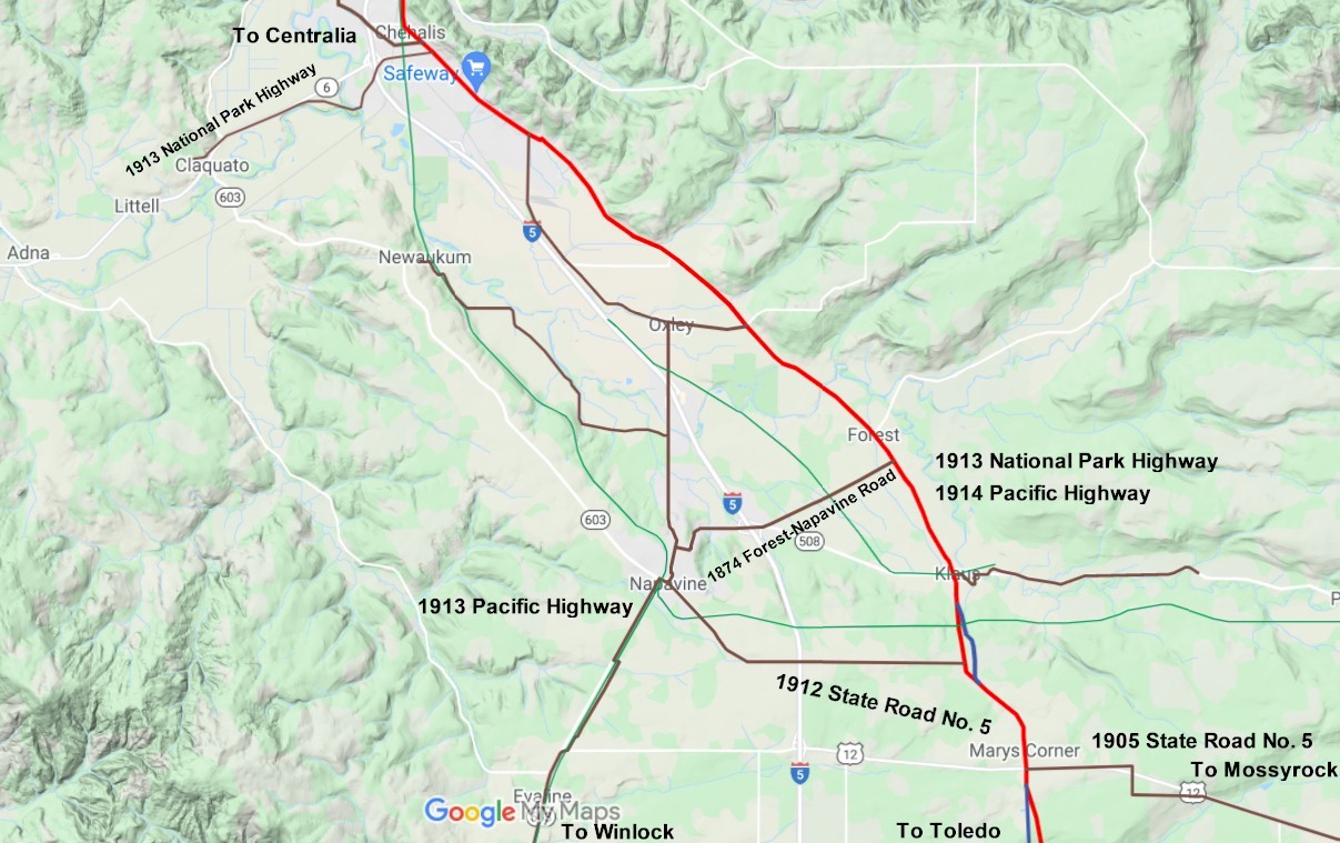
2021 map 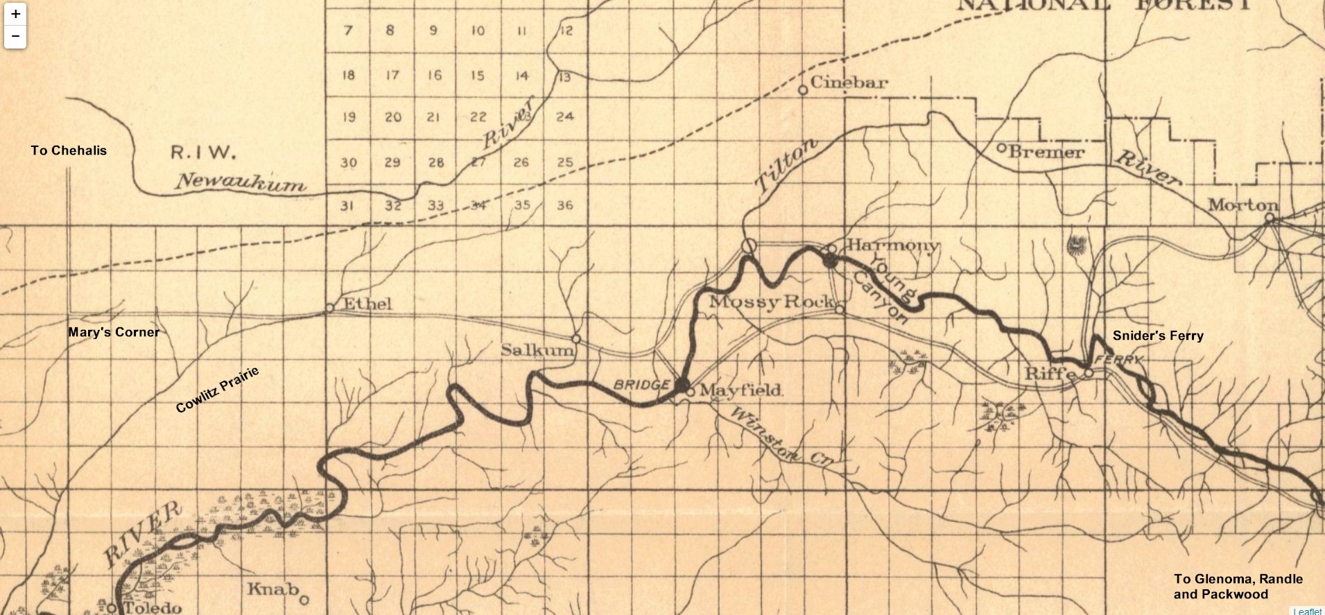
1910 map showing State Road No. 5 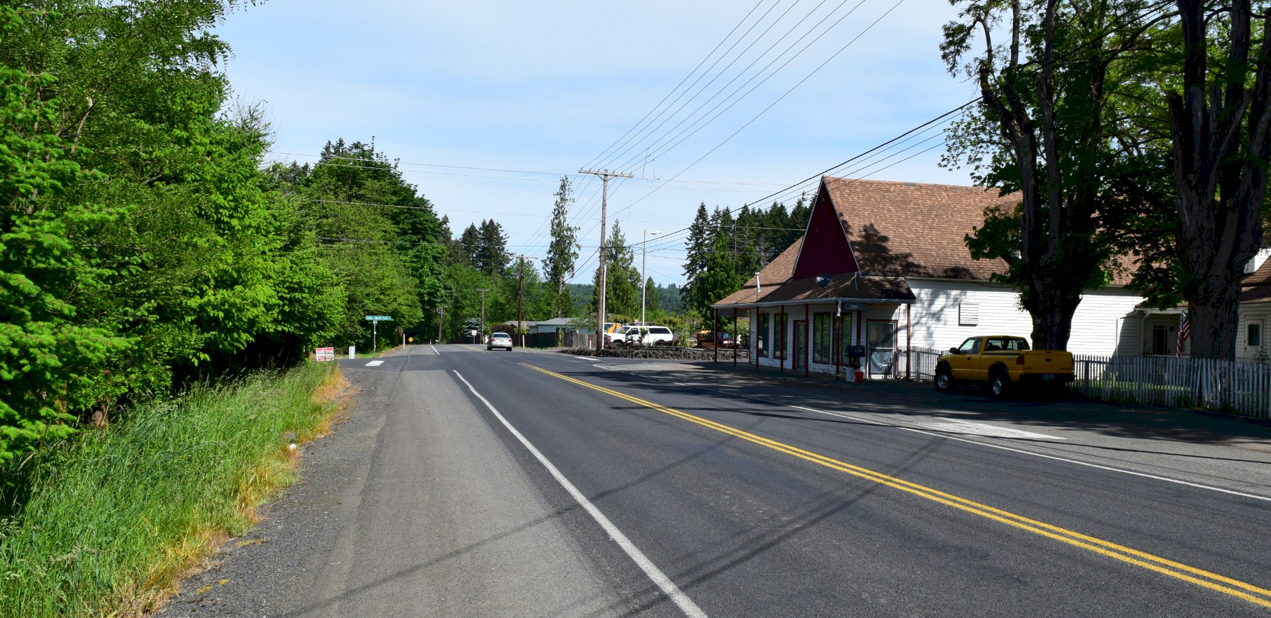
Looking north at the village of Forest. The building was the general store and post office in the 1890's. 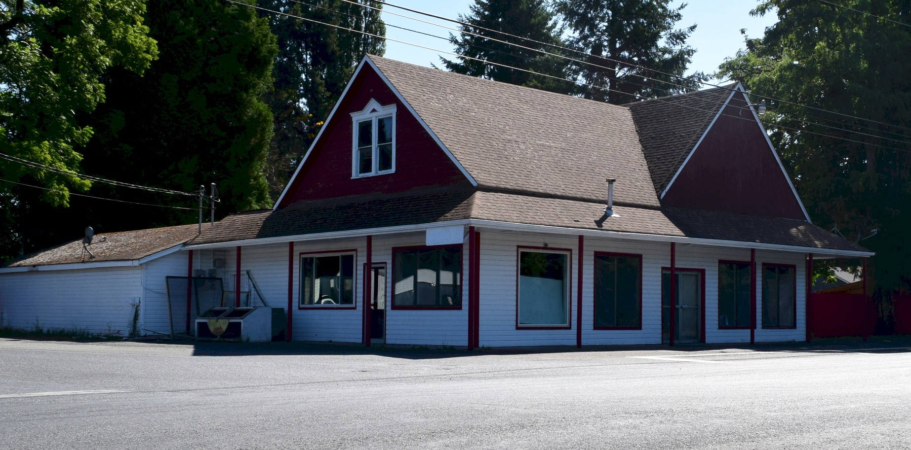
Forest Store 2021. |