![]()
The Historic Pacific Highway
in Washington
Mount Vernon to Bellingham
![]()
The Historic Pacific Highway
in Washington
Mount Vernon to Bellingham
A Brief History of Mount Vernon
In 1870 Jasper Gates and Joseph Dwelley first settled on the banks of the Skagit River, where the city of Mount Vernon is located. Harrison Clothier arrived in 1877 to teach school and joined in business with a former student, E.G. English. Clothier and English were later recognized as the city's founders and pioneer businessmen. The post office was established in November 1877 and Clothier was appointed postmaster. The city was named after Mount Vernon, VA, the plantation estate and resting place of George Washington. The two men laid out the city's first plan while the area was still heavily timbered. Mount Vernon's first industry was logging and camps were set up to log the new town site.
On December 7, 1911 Skagit county was preparing to construct a bridge across the Skagit river at the Riverside Crossing. The county called for bids for the new Riverside bridge on January 17, 1912. The county had already paid to the state their share of the cost of the bridge. This bridge was to complete a link in the Pacific Highway between Mount Vernon and Burlington and was to be a great convenience to the traveling public and the people of Skagit county.
By the beginning of the 1920's the State Highway dept. began to eliminate the elbow joints on state roads wherever possible. The Pacific Highway between Burlington and Edison Station was one of these places where the elbow jointed road made the route a mile longer between these two points. In the early 1920's the elbow jointed Pacific Highway between Burlington and Blanchard was straightened out and the new highway followed the trolley tracks. In the Ninth Biennial Report of the State Highway Dept. printed in 1922 shows that this section was straightened out in 1921 and 1922.
The Lake Samish Branch of the Pacific Highway
Before 1872 the only way into Whatcom county was either by boat or Indian trail. The Fort Steilacoom - Fort Bellingham Military Road which was constructed in 1860 only made it as far as Snohomish, and the road leading south from Fort Bellingham only made it to Whatcom (now Bellingham) before the Government discontinued the military road program. Between these points the Indian trail was used. In 1865 a telegraph line was strung between San Francisco and New Westminster, BC., and in Skagit and Whatcom counties, the line followed a trail which ran between Blanchard and Fairhaven.
In 1931 the Lake Samish branch extending from Burlington in Skagit County to Bellingham in Whatcom County was added to State Road #1 now known as U.S. Highway 99. Chuckanut Drive then became U.S. Highway 99 Alternate. This gave motorists 2 ways into Whatcom county. The Lake Samish branch of the Pacific Highway was then realigned from the railroad tracks at Bellevue (Just north of Burlington) to about 3 miles north of Alger. Between Bellevue and the Fish Hatchery the new road runs on the old Great Northern right-of-way.
The town of Edison is located on the Samish Flats about 11 miles northwest of Mount Vernon. The Samish Flats were formed by the Samish River and it encompasses the area around the town of Edison, extending from the Chuckanut range to with in a few miles of Bay View. The flat was reclaimed using dikes in the late 1880's and by 1890 many fine farms had been established.
In 1885 George Blanchard, homesteaded on land on the south side of the Chuckanut mountains on the Samish Flats. He then began logging operations. Blanchard was an ideal place to start a town. The Chuckanut Mountains were heavily forested with prime timber, while the Samish Flats south of Blanchard were extremely fertile for farming.The post office at opened on July 20, 1886 and was named Blanchard. George BLancard became its post master.
The completion of Chuckanut Drive helped usher in a new era of transportation for Whatcom and Skagit counties. In addition to providing needed access for Skagit valley farmers and local residents to the city of Bellingham, it also offered a unique opportunity to view some of the most spectacular scenic views anywhere in Washington State. The road was designated State Road 6 and was called the "Waterfront Road." By the time the road opened, it was becoming known as Chuckanut Drive.
The first bridge over Oyster creek was built in 1896 when the Waterfront Road was established as a state road between Fairhaven and Blanchard. This wooden bridge may have been located on Rock Point Road where it crosses the creek as the old wagon road ran along the shoreline for 3.5 miles from Blanchard north. At Pigeon Point the road may have climbed up and over the point on or near the present road. After traversing the hill the wagon road continued along the shoreline to just south of Clayton beach where it climbed the hill to meet the current road.
The first road to Chuckanut creek from Fairhaven was built in 1890 and ran down 24th & 25th streets to Fairhaven Ave. Bear hunters used this road to reach the trails to Chuckanut mountain which had a large bear population at the time. In 1891 this road was extended 1.25 miles to the quarry. The road was built by Henry Roeder and Mr. Roth using their own funds. The road began at the southern end of S. 16th Street and crossed (most likely forded) Chuckanut creek and then climbed the hill just below the present Chuckanut Drive at Okanogan Street. The road then ran through Woodstock farm and around the gulch to connect with the current road. After about a half mile the road started down the hill to the quarry.
The Fairhaven district in Bellingham occupies the area around Bellingham Bay that was formerly one of four pioneer settlements. The original plat of Fairhaven was filed on January 2, 1883, by Daniel J. Harris, the "Dirty Dan” Harris of local lore and legend. He named this area Fair Haven from the native "see-see-lich-em”, meaning "safe port” or "quiet place.” Dirty Dan was only one of the many colorful characters that comprise the rich fabric of Fairhaven.
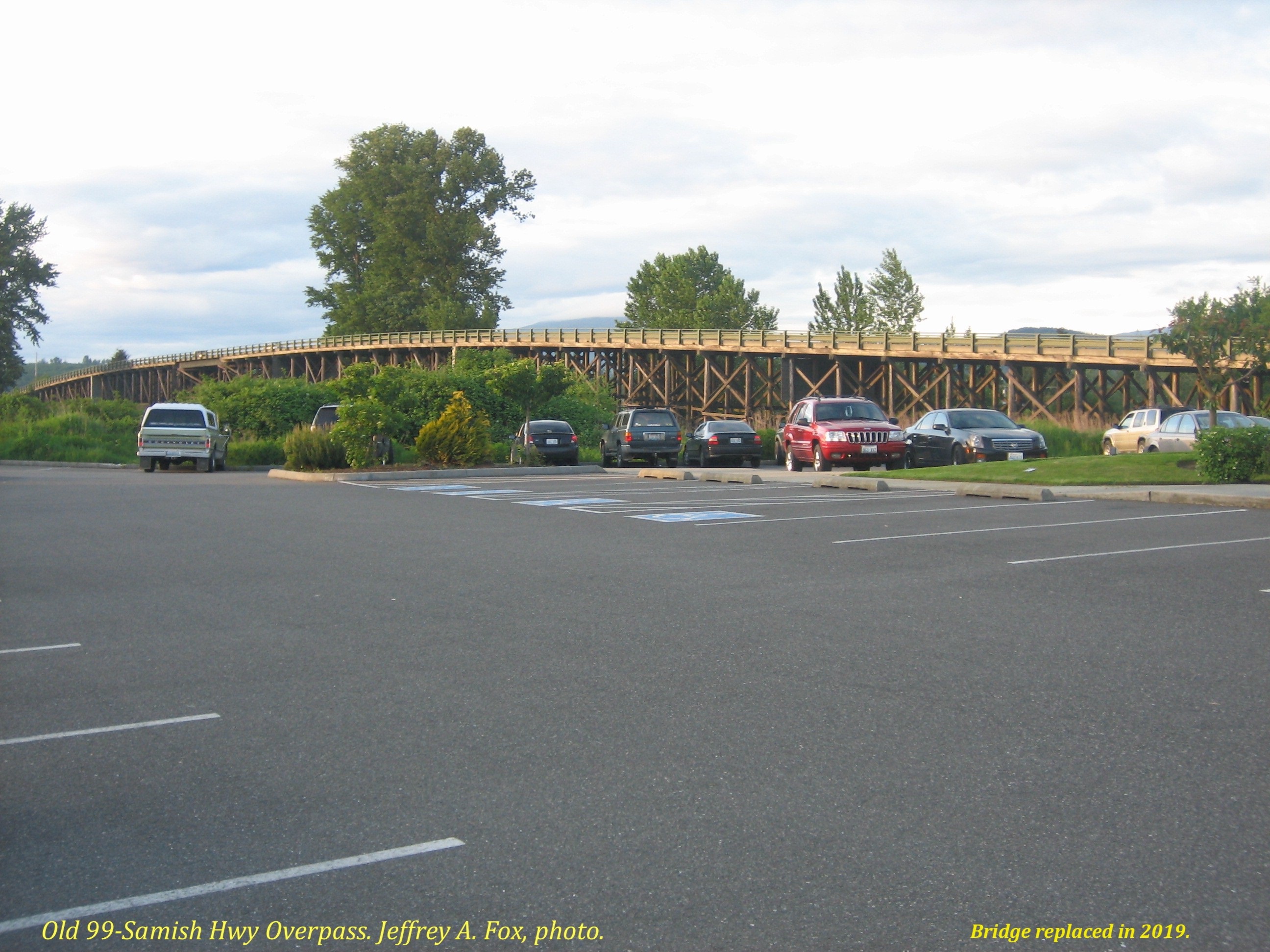 The Old 1936 Viaduct over the railroad tracks
north of Mount Vernon. This 1,000 foot long viaduct was replaced in 2018.
Photo courtesy Jeff Fox
The Old 1936 Viaduct over the railroad tracks
north of Mount Vernon. This 1,000 foot long viaduct was replaced in 2018.
Photo courtesy Jeff Fox

©2011-2022 pacific-hwy.net
All Rights Reserved