![]()
The Historic Pacific Highway
in Washington
Scatter Creek Crossing
![]()
The Historic Pacific Highway
in Washington
Scatter Creek Crossing
History of the Scatter Creek
Crossing
By Curt Cunningham
Scatter Creek
Scatter creek is a stream in Thurston county that begins about 3 miles northwest of Tenino and follows the ancient glacial drainage route 16 miles westward and empties into the Chehalis river at Helsing Junction, which is 4 miles west of Grand Mound. Scatter creek runs through a 915 acre protected area and wildlife reserve, located a mile and a half north of Grand Mound. The site is managed by the Washington Department of Fish and Wildlife and is one of the 5 units that comprise the Scatter Creek Wildlife Area. There are 2 main sections of the reserve, the North Tract and the South Tract and a 2.5 mile nature trail that loops around the perimeter of the entire North Tract. The South tract borders 183 Ave. SW and next to the cemetery is the site of Fort Henness.
Rock Prairie
Rock prairie is located north of Scatter creek 2 miles southwest of Tenino, and 6 miles northwest of Grand Mound. This prairie is not to be confused with Rocky prairie, which is located north of Tenino. During the Ice Age, the Puget Sound Glacier which covered the region only advanced as far as Scatter creek. When the glacier began to recede, the sand and gravel the ice had dug up was scattered across the prairie. This is where the creek gets its name. Miles Sand & Gravel has a large pit at the southeast edge of Rock prairie and is digging out these deposits. The Tenino-Bucoda gap was the largest of the 3 glacial drainage routes.
The Puget Sound Glacier crossed the Tenino valley and scattered till along its south side. Evidence obtained from the outwash gravels of Grand Mound and Rock prairies, and in the valley from Tenino to the Skookumchuck at Bucoda, indicated that the glacier abutted against the south hills at its maximum, and forced drainage to take a circuitous course through Bucoda and back around to Grand Mound before continuing down the Chehalis river valley toward the ocean. This route was abandoned early in the retreat of the ice and the water began to flow directly toward Grand Mound. Scatter creek runs in this drainage channel through Rock prairie.
Mima Mounds
The prairie has a peculiar geological phenomenon called the Mima Mounds. These mounds are on average; 8 feet tall and 30 feet wide, and are as close together as potato hills in a field. There are thousands of them spread out across the prairie. There are many theories of how the mounds were created, and the most plausible explanation is that the mounds were created at the end of the Ice Age.
In the book Glaciation of the Puget Sound Region by J. Harlen Brietz printed in 1913, said this about the Mima Mounds; "The mounds were formed when sand and gravel was deposited during the outwash of the melting glacier."
In 1841, U. S. Naval Explorer Lt. Charles Wilkes took an excursion to the Mima Mounds to see what was inside of them. He didn't find anything significant in them and from his account of the trip, seemed a bit bummed that nothing was found. You can read about his journey to the mounds at the link on the side bar.
The Black River - Mima Prairie Glacial Heritage Preserve is located on the Mima prairie west of Littlerock and 7 miles northwest of Grand Mound. The preserve is 637 acres and contains the best remaining examples of the mysterious Mima Mounds. An interpretive trail, meanders through the eerie mounds on the prairie.
The Pacific Highway
Traveling north on the Pacific Highway from Grand Mound, the road veers to the right as it goes around the hillside and begins to travel through the Grand Mound prairie in a northwest direction toward Tenino. Scatter creek is crossed after 3 miles, and the old Tilley place is reached 1.25 miles further. Abram Tilley once opened his home as a rest stop for travelers and stages using the Cowlitz Trail/Military Road. After 6 miles, of driving through the mysterious Mima Mounds, you will pass by the Corvin Ranch which is on the right, and some Alpaca Barns on the left. Ignatius Colvin was an early settler and became one of the largest landowners in early Thurston county, and by the mid-1860s he owned almost 3,000 acres. The ranch house he built in 1877 still stands on Rock Prairie.
The old Pacific Highway at this point veered to the right and went in a straight line eastward for about a mile and after passing the north edge of the gravel pit, the highway veers to the left at Mima Acres Dr., and then continued in a northwest direction to meet the Bucoda Road about a quarter mile south of the underpass. This road is still visible from the satellite maps, and you will also get a good view of the Mima Mounds. Before the double tracks were laid in 1911 and the underpass was built, the old road just continued in a northwest direction toward Hodgdon' Station.
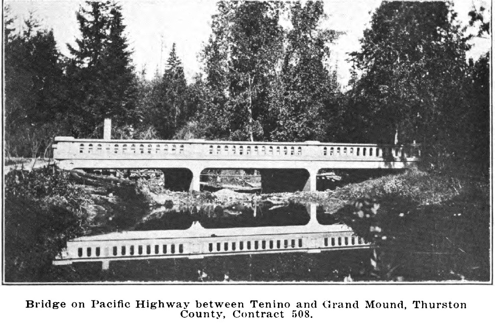
Between 1918 and 1920, the Pacific Highway between Grand Mound and Tenino was in the process of being paved with concrete, and the road was closed for traffic until its completion in 1921. The construction included a new concrete bridge over Scatter creek. During the paving operations, Travelers were detoured on to the Bucoda Road between Centralia and Tenino. This is when the highway was realigned to its current route.
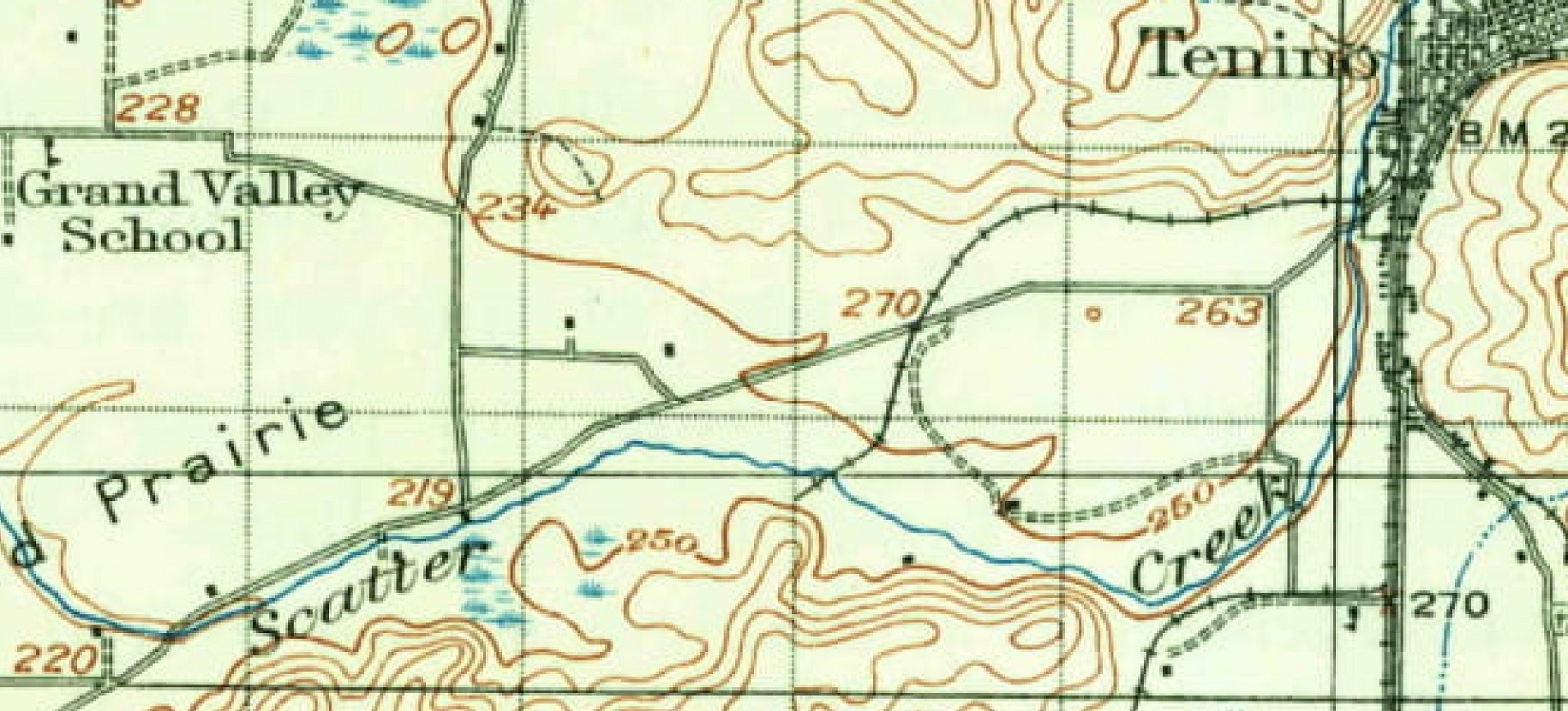
1916 map 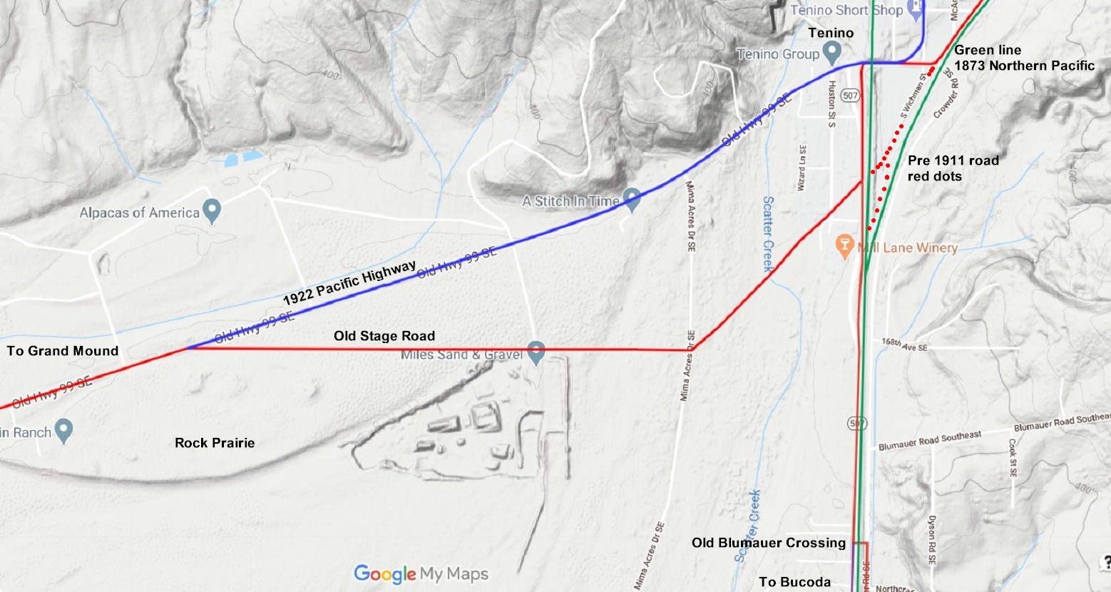
2021 map. Red line is the original road. The blue line it the completed 1921 highway. 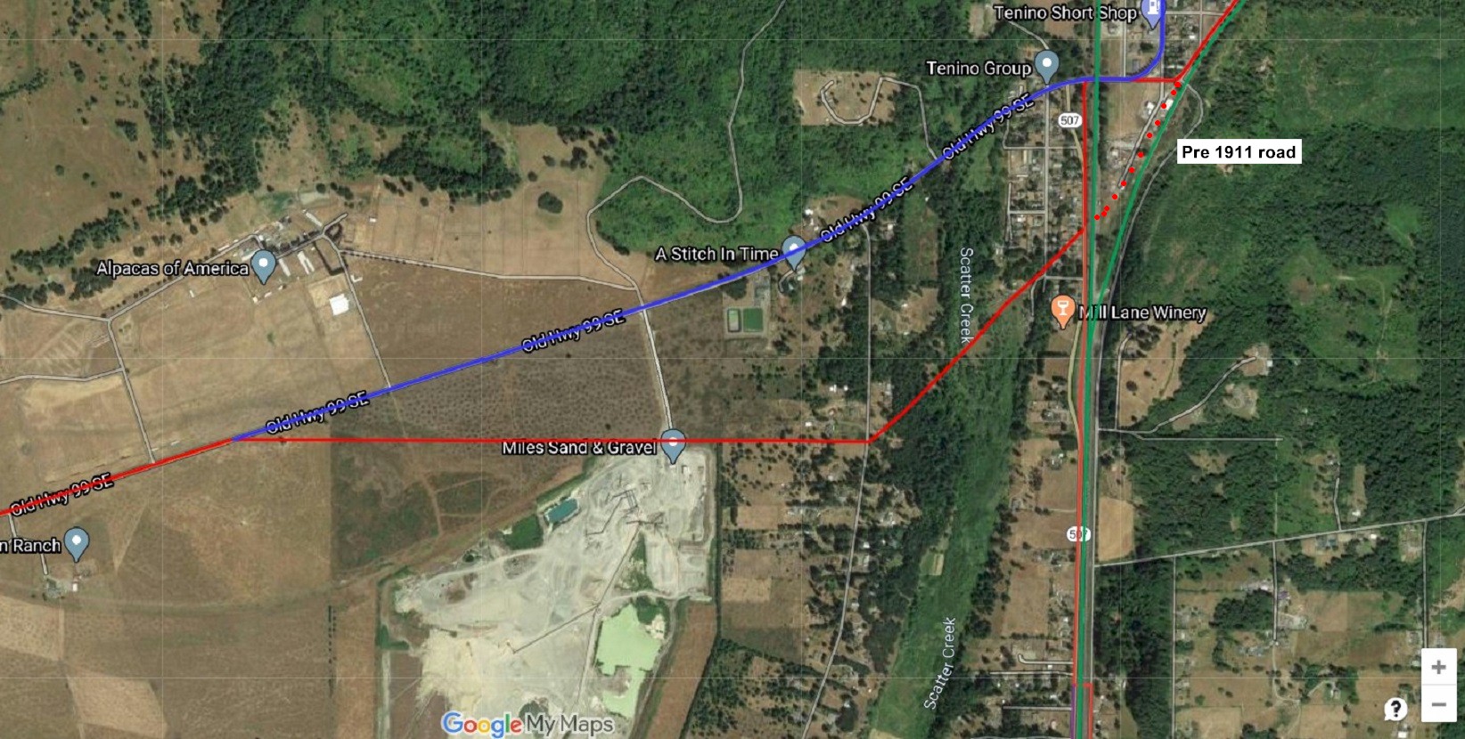
Satellite view. Red line was the Cowlitz trail, the Military Road and the stage road and became the Pacific Highway from 1910 to 1920. The blue line is the completed 1921 highway. 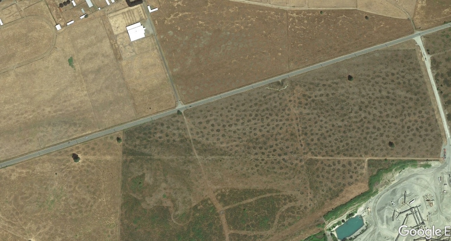
Satellite view of the old highway as it crosses through the Mima Mounds. |