![]()
The Historic Pacific Highway
in Washington
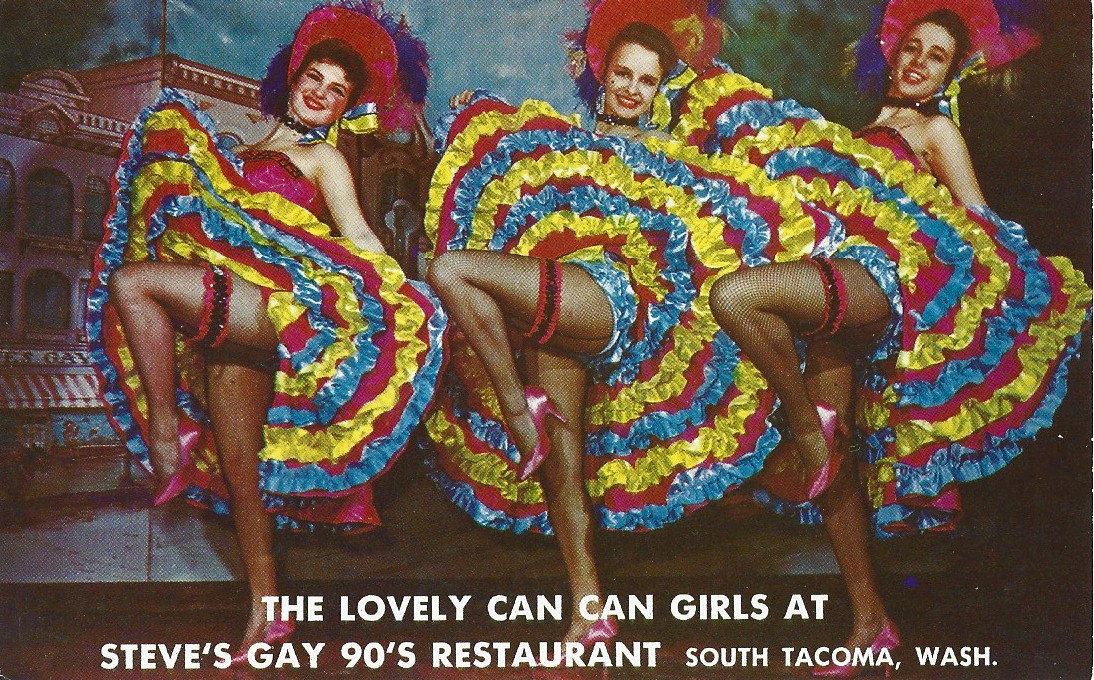
South Tacoma
![]()
The Historic Pacific Highway
in Washington
South Tacoma
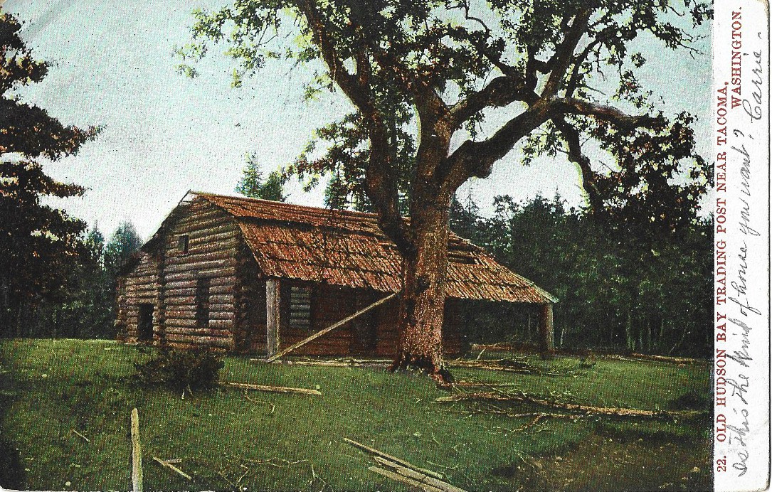
This post card from 1910 shows the old Sales cabin which was located near Parkland.
History of South Tacoma
By Curt Cunningham
The South Tacoma Drainage Channel
Between Dupont and South Tacoma the Pacific Highway traverses the Steilacoom plains. The plains were created during the later stages of the Ice Age when the enormous glacier deposited 100s of feet of glacial till. This is what gives the plains its gravelly soil. As you continue north on South Tacoma Way, and after passing S. 74th St., you begin to enter the South Tacoma drainage channel.
This 5 mile long, and half mile wide valley was created when the Puget Sound glacier had retreated far enough north to open a low spot in the hills allowing the water from Lake Puyallup to drain through it. Over time the water cut through the hill creating the valley which we see today. When the glacier had retreated far enough to allow the drainage of the water to flow around Point Defiance, the level of Lake Puyallup began to lower which dried out the channel.
Lake Puyallup was a large glacial lake which formed when the Puget Sound glacier began to retreat during the later stages of the Ice Age. At one point during the melt, it had opened up the Puyallup valley but still blocked the path of the Puyallup and Carbon rivers, this is when the lake began to form. The water had filled the valley between Fife and Auburn in the north and Orting in the south.
Before the South Tacoma channel opened, Lake Puyallup emptied west from Orting and South Hill across the Steilacoom plains into the Clover creek channel. The water then drained through the Sequalitchew creek and Chambers creek outlets. As the glacier retreated further it opened the South Tacoma channel which began to lower the level of Lake Puyallup which eventually dried up the Clover creek channel. The South Tacoma channel would now be the only outlet for Lake Puyallup until the Point Defiance outlet opened.
The Northern Pacific, the old Tacoma water flume, and the Pacific Highway, were all built along this ancient riverbed. The freeway enters the channel at the Highway 16 interchange and follows along its south edge down to the tide-flats. This section of the channel has been known to the locals for years as "Nalley Valley." The name comes from the old Nalley pickle plant which once made pickles there, and during its years of operation, the valley would smell like dill pickles.
The First Road to Seattle and Tacoma
In the 1850's Andrew Byrd operated a saw and grist mill on Chambers creek at the north end of Steilacoom lake. In 1852 a wagon road was constructed from this sawmill eastward to Puyallup. In 1853, a road was constucted from Seattle to Puyallup to meet the Byrd's Mill road. Through King county the road was known as Territorial Road #4. In 1857 it would become a section of the Ft. Steilacoom-Ft. Bellingham Military Road. In 1941 the Byrd's Mill road was designated as State Historical Road #1. Today State Route 512 follows fairly close to the route of the old road. The old road to Seattle is still called Military road.
The first wagon road to the Tacoma tide-flats from Steilacoom was constructed in the early 1850's. This road followed Byrd's Mill road to Fern Hill, where it branched off and traveled in a northeast direction towards McKinley park. This road was also a section of the Indian Henry trail that ran between Tacoma and Eatonville.
The Puyallup Plain
The area that will become South Tacoma was known as the Puyallup plain by the British and French who worked for the Puget Sound Agricultural Company (PSAC). This plain was a part of the northwestern section of their vast claim. In 1840 the PSAC established a farm on the Puyallup plain close to where South Tacoma is now. It is unknown how long this farm operated. On a 1855 map it is notated that this was a farm in 1840. In 1869 the PSAC sold their claim to the U.S. Government and the following year the land was opened to settlement.
The first settlers in the area which will become the business center of South Tacoma were; John Neison, James P. McConville, and Thomas Kanavan. Sometime around 1870 John Niesen took a 160 acre claim which was located between S. 50th St. and S. 58th St., and between S. Mason Ave. and South Tacoma Way. Niesen, would live in the area for the rest of his life and would pass away in 1898 at the age of 80. Niesen was buried at the Old Tacoma cemetery.
Just north of Neisen was James P. McConville who purchased 40 acres in 1888 which was located between S. 48th St. and S. 50th, and between S. Mason Ave. and South Tacoma Way. James McConville and his wife Mary moved to the Nisqually bottom in 1889 after their house burned down, and there they opened the Maxfield hotel in what will become the town of Sherlock.
North of McConville was Alexander Heisen who took a 160 acre donation claim which was located between S. 39th and S. 48th, and between S. Mason Ave. and South Tacoma Way. Heisen migrated from Germany in 1848 and arrived at Steilacoom in 1851. Not long after, he took a claim at South Tacoma. During the War of 1855, Heisen served under Captain W. H. Wallace and Captain Urban East Hicks.
In 1864 Heisen married Mary Elizabeth (Reylea) Bradley. Mary had crossed the Oregon Trail in 1849 and married John Bradley at Steilacoom in 1852. John Bradley was the first sheriff of Pierce county and had taken a claim which was located on Flett creek north of Lakewood. Bradley must have passed away in the early 1860's, because in 1864 Mary Bradley married Alexander Heison. In 1866 the Heison's sold their property at South Tacoma and moved to Clark county where he founded the town of Heisson in 1904. The Heison's would live at their home in Clark county for the remainder of their lives and there they raised 13 children. Alexander would pass away in 1912 and Mary would pass in 1915.
To the south of John Nieson was John and Elizabeth Rigney who took a 640 acre claim between S. 58th St. and S. 74th St., and between Lakewood Dr. and South Tacoma Way. They first settled somewhere near the Meadow Park golf course, and later in 1873 took a claim along the future South Tacoma Way. The Rigney's built their new cabin where McClain's Soil Supply on S. 74th Street now stands. The place was once called Rigney hill. In 1874 the railroad built its line 90 feet east of the Rigney cabin. In 1880, the Rigney's sold their claim and moved to Steilacoom where they became prominent members of the community.
On the east side of South Tacoma Way was Thomas Kanavan who arrived in 1852 from Ireland. He settled on 160 acres south of the cemeteries. In 1869 Thomas married Eliza Jane Rigney, daughter of John and Elizabeth Rigney. In 1873 the Kanavan's claimed their land under the 1862 Morill Land Grant act. In 1889, his property would be platted out as the Monticello Park and Lookout Park subdivisions. The Kanavan's would remain in the area the remainder of their lives and they raised 10 children. Thomas Kanavan would pass in 1912 and was buried at the old Tacoma Cemetery. Eliza would pass in 1922 and was buried at the Calvary cemetery near where she grew up.
North of the Kanavan's is where the Old Tacoma cemetery and the Oakwood Hill cemetery are located. Originally these resting places were one large graveyard when it was established by the city of Tacoma in 1875. In 1884 Tacoma went out of the cemetery business and sold the graveyard to private individuals who spilt the grounds into the separate burial places.
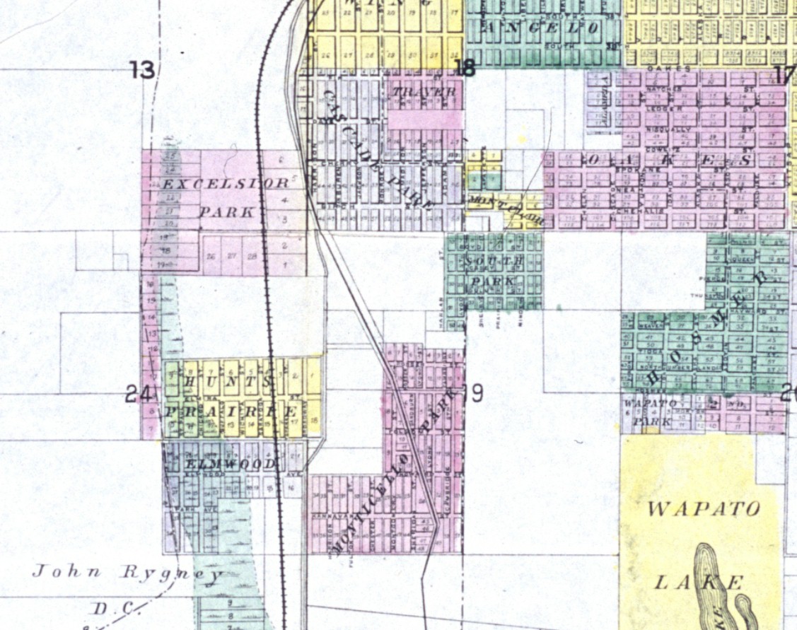
North of the cemeteries was Aaron G. Vradenburgh who in 1889 claimed 160 acres. Not long after purchasing the property he platted the land into the Cascade Park subdivision, which is located along South Tacoma Way between S. 38th St. and S. 48th St.
In 1889 the first subdivisions in South Tacoma were established. These were; (from north to south and beginning at S. 38th St.) Cascade Park, Excelsior Park, Lookout Park, Monticello Park and the Elmwood addition. Further south between S. 72nd and S. 76th was Squires subdivision. In 1890 the Hunt's Prairie subdivision was platted. This subdivision was located between Excelsior Park and the Elmwood addition. John Niesen lived in-between Excelsior Park and Hunt's Prairie.
The South Tacoma Car Shops
In 1891 the Northern Pacific built a car shop in the valley on about 100 acres between S. 38th and S. 56th streets along their mainline. This facility was to build and maintain the railroad's rolling stock west of the Mississippi. The area selected included the center block of the north half of the Hunt's Prairie subdivision, the center of the Excelsior subdivision and the center of John Niesen's claim.
The railroad named the plant the "Edison Car Shop" after the famous inventor Thomas Edison. In the beginning they employed just 300 mechanics. In 1892 they cast their first iron wheel and afterwards began to manufacture cars. The car manufacturing increased the workforce to 450, and at its peak they employed around 1,200. In 1896 the car shop increased its output of newly constructed railroad cars. On February 7, 1896 printed in the Mason County Journal was an article about an announcement made by the Northern Pacific that they were to begin operating its South Tacoma car shop at full capacity in the construction of railroad cars. At the time there was a shortage of boxcars amongst the various railroads, and the Northern Pacific saw an opportunity to fill this need.
The railroad had decided on the South Tacoma shops because of the abundance of timber nearby and the close proximity to a foundry. Before they made their decision, they had a test conducted using Western Douglas fir and Eastern Oak. On January 24, 1896 H. W. Topping, of Parker and Topping along with G. H. Gilman, General Foreman of the N. P. shops, and J. T. Howson, Manager of the American Foundry Co. of South Tacoma, had certified a test they made showing that Washington Douglas fir had a higher breaking point than Eastern Oak.
The Western Iron & Steel Co. built a steel rolling mill at Lakeview in 1894. The foundry began operations on May 1. 1895 with 3 coal heating furnaces 2 rolling trains and a 30 ton hammer. This plant manufactured the axles, and springs for the car shop until 1904. This is when the foundry was dismantled and moved to West Seattle under the new name of the Seattle Steel Company.
In 1895 the car shop produced 100 freight boxcars, and at the beginning of 1896 they had built 25 boxcars, 50 flatcars, and 25 large coal cars. Between 1891 and 1896 they had produced a total of 700 cars.
On February 9, 1896 Andrew F. Burliegh of the Northern Pacific was under fire from people in Minnesota who were terrified of his receivership being extended, and his plan to move the headquarters of the Northern Pacific to Tacoma, which didn't happen, said the following about the South Tacoma Shops; "I know I have been severely criticized for that plan, and the criticisms on this point have been likewise inspired by Eastern friends who desired me not to succeed."
"But the plan was really and sincerely based on the considerations of which I have just spoken. We have in this state the best timber in the country for car building. Timber which by actual test has been shown to be better than white oak and better than yellow pine, because it is stronger than oak and lighter than pine. We already have the plant and the shops at South Tacoma are capable of furnishing employment to from 1,500 to 1,800 skilled mechanics."
"At present this great plant, which is one of the finest in the country, furnishes employment to about 400 men. who scarcely suffice to give an appearance of life to the shops, and who are employed in the ordinary work of repairing the equipment of the road. Further, it is believed by those competent to judge, that we can build better cars for the same cost than can be built elsewhere in this country. The finest freight cars in the world, with a capacity of thirty-five tons, have been constructed in these shops."
Over its 84 years of existence the shop built and maintained all the rolling stock west of the Mississippi. At it's peak, there were 36 buildings covering 15 acres with over 1,200 people employed. The South Tacoma business district along South Tacoma Way sprang up as a direct result of these car shops. Operations would continue until 1974.
South Tacoma, a Town within a City
After the car shops began operations in 1891 the Northern Pacific built a depot they called Edison station. Later that year between the Excelsior Park and Hunts Prairie subdivisions, the railroad platted out a new 3 block subdivision called "Mechanics." In the beginning the railroad did not charge its employees to ride the train to work from downtown Tacoma, but on July 1, 1892 they took away this benefit and began to charge them 5 cents. This was to nudge them into buying their lots in the Mechanics subdivision. This subdivision was located between the car shops and S. Puget Sound Ave., and between S. 50th and S. 56th streets.
The area around the car shops became known as the Edison suburb and it could have grown into a town of its own, but the area was absorbed into the city of Tacoma when it expanded their city limits on April 17, 1891. The South Tacoma post office was established in 1891 not long after the car shop began operations. The original name of the post office may have been "Excelsior" or "Edison Car Shop." This is because there was already an Edison post office in Washington, and the Postmaster general would have refused to issue another post office with the name "Edison." Although by 1894 the post office was called Excelsior. The following paragraph may shed some light into this issue.
On January 13, 1896 the Tacoma Times said that; "First Assistant Postmaster General, Jones had agreed to make the post office at the Edison car shops in Tacoma, which was now known as Excelsior, a substation of the Tacoma post office. The railroad had recently changed the name of the car shops to South Tacoma. They decided to make the post office a sub-station, because the name Excelsior always caused some misunderstanding, and it was impossible to call the office Edison, as there was already an Edison post office in Skagit county, Washington."
The Edison Road
The old wagon road between downtown Tacoma and South Tacoma was once known as the "Edison Road." It began on Center St. near Yakima Ave., and it traveled west to Walnut St., which is now called Sprague Avenue. The road then turned south, crossed over the tracks and followed the old water flume to S. 50th and S. Puget Sound Ave. in South Tacoma.
This road was built in the 1870's and improved in the 1890's. It was a fairly good road, but by 1904 after years of neglect, it had resembled a backwoods trail. There were numerous complaints about the ruts and mud holes, and it was impossible to haul a fully loaded wagon over it. In some places the roadway was so narrow that the passing of 2 wagons was very difficult, especially if one was drawn by a skittish horse.
This road was the gateway between the business center of Tacoma and the prairie country on the south. Tacoma merchants were losing considerable business because of the condition of this road. It was said by the tourists of 1904 that; "the prairie country for 30 miles south of Tacoma has some of the prettiest natural driveways to be found anywhere." They also had many unfavorable comments on the condition of the main road leading to these driveways, and many had wondered if the people of Tacoma even knew about the advantages of that section of the county as an attraction to tourists.
During the 1890's after the railroad car shops began operations, the city had the road graded and drains installed, but afterwards the road was neglected. The terrible road conditions increased the costs for the South Tacoma merchants who had to make double the trips to the wholesale warehouses downtown because the road couldn't handle heavy laden wagons.
The city must have heard the grumbling of the merchants and tourists because in June of 1904 the "Edison road," from Bailey St. (now called S. Wilkeson St.) and South Tacoma was re-graded and graveled making the route between Tacoma and South Tacoma easier for wagons. This improvement also made the route accessible for automobiles.
At the beginning of 1909 South Tacoma residents began to demand a better road between South Tacoma and the downtown business district. The city also wanted a better road but they did not have the funds to build it. On February 18, 1909 the city announced some good news. They said they were able to secure the old Union Pacific right-of-way that ran down Center St. and around the hill to Jefferson Street. All they had to do was connect Center St. to Jefferson Ave. with a new road, which would give the Edison Road a much easier grade.
There was still the issue with paving and in the spring of 1910 a meeting was held by the Pierce county commissioners to discuss the issue. After the lively meeting they ended up approving 2 to 1 to pay up to $50,000 for asphalt paving of the road from Tacoma along the water flume line to South Tacoma.
Then on April 10, 1910 the "water ditch road" from Center St. to South Tacoma was put on hold because the properties along the road could not stand the assessment under the plan they had. They then decided to grade the street and make it ready for paving until such time that the properties could withstand the assessment. The Tacoma Auto Club had offered to pay $5,000 toward the costs of paving if it could offset the assessment, so that they could have a good way out to the prairie. This did not happen.
After 2 years of waiting the road was to finally be paved. Pierce county, the city of Tacoma and the adjacent property owners had come to an agreement that they would all chip in and help pay for the project. On June 6, 1912 the paving contract for the Edison Road was let to the Washington Paving Co. for a low bid of $88,447.00. The construction was completed by December of 1912.
In 1914 a new road was constructed from "M" St. along the flume line to S. 38th and S. Cedar St., which improved the road and reduced the grade on the hill even more. This new road crossed the Northern Pacific at "M" St. on a bridge, thus eliminating one of the most dangerous railroad crossings in Tacoma. The old crossing was at Bailey St. which is now called Wilkeson Street.
On July 12, 1915 work began on paving the South Tacoma road as it was now called, from the intersection of Cedar St. and S. 38th St. to the intersection of "M" St. and Center Street. This was the last unpaved link of the main highway to South Tacoma. This paving project cost $38,000 for a 20 foot roadway. After this job was completed, the road was continuously paved from Center St. in Tacoma to the Country Club on American lake. Between the intersection of Center St. and "I" St. and the intersection of S. 27th St. and Jefferson Ave. the road was planked.
The road was unofficially called the Edison road and the South Tacoma road. It was also known as the Steilacoom-Tacoma road. Officially between Center St. and Union Ave. the highway was called Montgomery Street. Between Montgomery St. and S. 58th St. the road was known as Edison Boulevard. Between S. 58th St. and the city limits at S. 80th St., the highway was called Union Avenue.
From Center St. in Tacoma to Steilacoom Blvd. at Lakewood, the paved roadway was 20 feet wide. From Steilacoom Blvd. to Dupont the road was 16 to 17 feet wide. The road was too narrow and could not handle the rush of traffic that it was now carrying. After Camp Murray and later Fort Lewis were established, traffic dramatically increased on the highway south of Tacoma making matters worse. During the weekends and on holidays the road between the army base and Tacoma would be jammed with vehicles throughout the day and most of the night. Many complaints started to come in concerning the traffic jams forcing the authorities to look for a solution. One of the ideas was to build a new road through Lakewood and around the west side of American lake. The other idea was make the existing highway a 4-lane thoroughfare.
On August 18, 1917 the Tacoma Times said that; "The proposed 4-lane road was to be built on the old Union Pacific right-of-way between Center street and South Tacoma, which was abandoned when the paved boulevard was built. Union avenue would be widened at the Tacoma cemetery, and also between 60th and Rigney hill, where it was too narrow to accommodate more than 2 cars abreast. This project would also create a large roadway through the city from Center street to Union Avenue."
Unfortunately the city had no available funding and they could not find any other way to pay for such a project except for asking the citizens to pay for it. State law forbid state highway funds to be used within an incorporated city's limits. So in the spring of 1918 a $90,000 bond issue was put to a vote of the citizens of Tacoma, and the people said "no" which ended up killing the measure. By now the 2,000 foot strip of planking between Center St. and Jefferson Ave. had deteriorated making the road dangerous. They had planned to repair it but did not have any money to pay for it. Commissioner Atkins said if he could use the funds from the 1919 appropriation he would have done it, but he was not sure if that was legal and said he would talk to Mr. Harmon, the city attorney.
In 1924 the city of Tacoma began to improve the highway from South Tacoma to the downtown business center. This is when the highway was rebuilt along the flume line bypassing Montgomery Ave. between S. 47th and S. 35th. Between "M" St. and Pacific Ave., a new road was constructed. This new route bypassed Center St. and Jefferson Avenue so now cars who were traveling on the Pacific Highway, did not have to drive into the downtown business center. This helped reduce transit times and congestion, but the highway continued to be a 2-lane road through the city of Tacoma.
On September 30, 1926 the Pacific Highway through the city of Tacoma had the following types of pavement; 4.28 miles of asphalt, 1.41 miles of sheet asphalt, .48 miles of concrete, 2.01 miles of brick, and .06 miles of other types. Four years later on September 30, 1930 the pavement of the Pacific Highway through Tacoma had; 5.91 miles of asphalt, .59 miles of concrete, 1.14 miles of brick and .56 miles of other types.
On June 18, 1934 the Hayden Cartwright Act was signed by President Franklin Roosevelt which enabled Federal funding to be used on major highways through incorporated cities. In 1934, 2.42 miles of South Tacoma Way was paved with funds secured by this act.
The final phase in the construction of the Pacific Highway leading south out of Tacoma was in 1936 when the 4-lane Nisqually cut-off was constructed across the Nisqually valley. Tacoma was to finally get its 4-lane thoroughfare. The new route began at the intersection of E. "G" St. and Puyallup Avenue in Tacoma and then followed S. 26th St. to South Tacoma Way. At Steilacoom Blvd., the elbow joint which crossed the tracks was bypassed with a new 4-lane road that continues south and crosses under the mainline. This new road eliminated 2 dangerous railroad crossings.
1890 South Tacoma 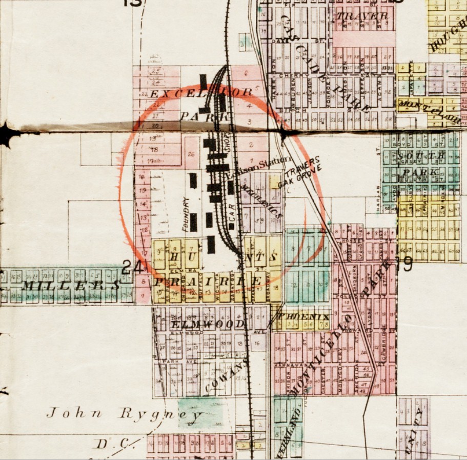
1891 South Tacoma 
1902 South Tacoma 
1918 Pacific Highway through South Tacoma |