![]()
The Historic Pacific Highway
in Washington
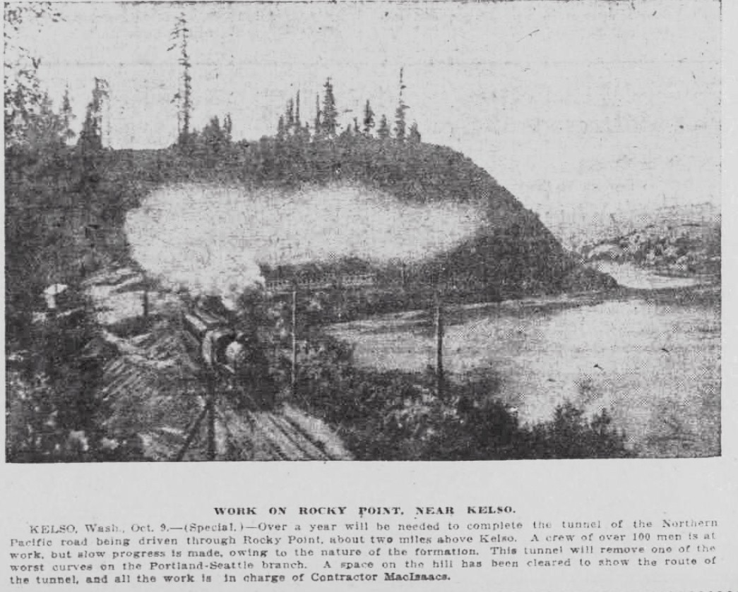
Rocky Point
![]()
The Historic Pacific Highway
in Washington
Rocky Point
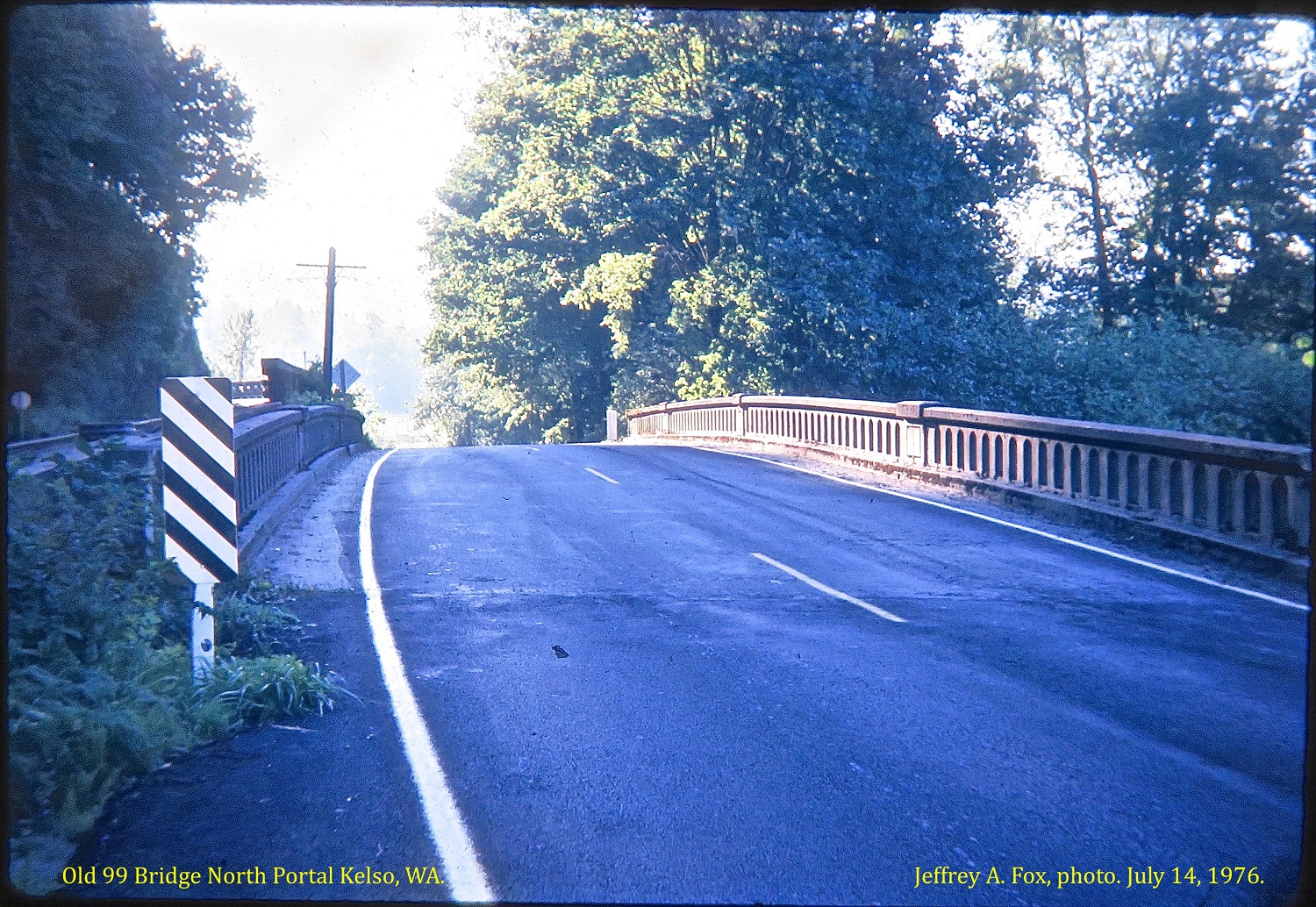
Original North Portal Bridge constructed in 1924 and replaced in 1994. Photo taken July 14, 1976 and is courtesy of Jeff Fox.
History of Rocky Point
By Curt Cunningham
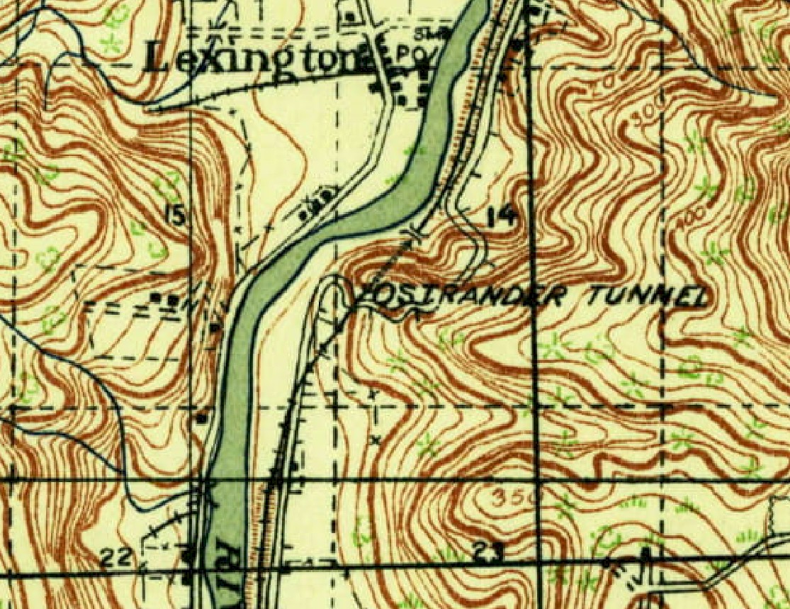
Rocky Point is a small mountain of blue basalt about 250 feet high, overlooking the Cowlitz river about 2.5 miles north of Kelso. The mountain is like a thumb sticking out blocking the path of the river and rises steeply forcing the water to flow around it. The mountain has been a natural barrier for north-south overland travel on the east side of the Cowlitz river. When the Northern Pacific (N. P.) completed its road through Kelso in 1871, they had to blast a ledge to get the tracks around the point. This dangerous curve was considered the worst section on the entire line between Portland and Tacoma.
On August 17, 1906, the Oregon & Washington Railroad (O & W) announced plans to build a line between Portland and Seattle. This proposal started a bitter fight between the two railroads over the right-of-way around Rocky Point. The O & W would have to build alongside the N. P. tracks as it was the only way around the mountain. In an effort to shut out the O & W, the N. P. purchased a large section of land at the point. The O & W then filed a lawsuit to obtain a right-of-way around the mountain.
Many property owners willingly granted the O & W a right-of-way through their lands, welcoming it as a competitor. The strategic purchase of the land around the point had angered these landowners, and like most of the public at the time, were not happy with the Northern Pacific's monopoly.
During August of 1907, the O & W began to clear and grade portions of the right-of-way that they had secured. On February 1, 1909, the Northern Pacific and the O & W reached an agreement to allow the O & W trackage rights over the N. P. line between Portland and Tacoma. The O & W abandoned their right-of-way and much of the previously graded roadbed became a part of the Westside Highway years later.
On August 12, 1909, Northern Pacific railroad survey crews were busy laying out a new double track line between Portland and Tacoma. This new road eliminated many dangerous curves saving about 2 hours off the travel time. This new route required a tunnel to be bored through Rocky Point. On September 2, 1909, construction crews began to arrive at the point. M. Mac Isaacs was the contractor and M. Tremaine was the supervising engineer for the railroad. The tunnel is 1,150 feet long, 29 feet wide and 27 feet high, and was completed on December 19, 1910.
On July 8, 1910, the Cowlitz county commissioners paid a visit to the Larson place north of Kelso. They wanted to secure a right of way for a temporary county road pending the abandonment of the old line by the Northern Pacific. The current county road was on land owned by the railroad and the lease expired any time they demanded possession. The new double tracks ran through this land and the new tracks would be laid over the current county road. It was estimated that this arrangement saved the county at least $40,000, as it did not necessitate any new construction.
Cowlitz Gardens Road is on the old right of way. The old wagon road on the south side of the hill ran where the double tracks are now and climbed up a steep grade and over the hill where the freeway runs, and connected to Pacific Avenue Spur on the north side. During the construction of the tunnel a detour road was built across the top of the hill to the west side of the old right of way, which was still in use. This made for 2 dangerous railroad crossings. After the tunnel was completed, the original road on the south side was moved east. Now there were 2 routes on the south side of the hill.
The first of the 2 routes (traveling north from Kelso.) crossed the tracks just north of town at Williams Ave. and ran along the west side of the old right of way (Cowlitz Gardens Rd.) and crossed over the tracks again and then up the hill traveling east across the tunnel to connect to the original road. The other route (traveling north from Kelso) ran along the east side of the tracks to meet the original road going over the hill.
Carrolls Bluff was one of the most difficult places for the motorist traveling on the Pacific Highway and was known as "Profanity Hill." The narrow path was dangerous and would take an inexperienced driver a few hours to negotiate the terrifying 2 mile ordeal. The name "Profanity Hill" was also used as the name for the steep incline at Rocky Point.
On August 25, 1910, a group of 12 motorists from Portland arrived by steamer at Carroll's Landing for a trip to Seattle. After learning of what lies ahead on the road, only 3 drivers continued onward and the others reloaded their cars and steamed back to Portland. It rained almost continuously and the road was extremely bad. Only by grinding ahead on second gear was it possible to get through to their destination.
The Buick broke down before reaching Kelso and the occupants took the train to Seattle. O. E. McCarthy wrote about climbing over Rocky Point; "Not far from Kelso the road between Portland and Seattle climbs "Profanity Hill," it is well named. The way is corduroy climbing the incline like steps. Figuratively speaking, a cloud of sulphurous blue hangs over the summit and is constantly increased from the seething wrath of the hill climbers. It was expected to be possible to reach Chehalis Friday night, but with the Locomobile running on second gear in mud that reached to the pans, and with the lighter White Gas Car following in its track, Toledo was the farthest point that could be reached. All the time it was raining."
On April 30, 1911, railroad officials and county commissioners, assisted by Everell Collins of the Ostrander Railway and Timber company, met to discuss the matter of improving the Rocky Point road at the tunnel using the old railroad bed as a county highway. This work had started the previous year and when completed late in the fall, removed two stretches of road that were nerve racking to motorists. This is when the highway was routed onto the abandoned right of way around Rocky Point.
On November 9, 1913, Ed E. Cohen who worked for the United Auto Company took a trip from Seattle to Portland. The following is his account of the road between Castle Rock and Kelso; "When I reached Napavine a storekeeper came out, looked at me and drawled; "Why in Sam Hill didn't you take the right-hand road, young feller?" Cohen replied; "The right hand road might be as level as Main street for all I cared, but that I was going to stick to the Pacific Highway all the way down just to see what it was like. I had no intention of going to Mount Rainier or some equally uninviting place at that time, like other motorists along the route have done." (From 1910 to 1915, and during road construction from 1915 to 1919, the Pacific Highway ran through Napavine.)
"After that it was clear sailing until I was about two miles out of Castle Rock, except for hitting an occasional mud hole. One of these mud holes was the entire width of the road and about two feet deep, almost throwing me over the steering wheel and giving me a nice muddy shower. About four miles out of Castle Rock I thought I had met my Waterloo. There was a space of about 60 feet that the road builders had left unfinished, with ruts and holes from one to three feet deep."
"A man passing by told me it would be impossible to get through and that he had pulled eight machines out within the last few days; but I decided to take a chance. Accordingly, I carried a few fence rails, threw them into the deepest holes and then made a dive and a splash. My pan was jammed up a little, but otherwise I got through without any damage. I passed a high-powered machine this side of Kelso being pulled by a team of horses, beside all power on low gear. I was compelled to take the side of the road to pass, and the way the little car plowed through the slippery mud was the surprise of my life."
"After arriving in Portland we looked the car over thoroughly and not a thing was wrong except the dent in the pan."
On January 6, 1918, after a heavy rainstorm, a rock slide occurred at Rocky Point that blocked the highway. The road remained closed until Spring when workers could remove the rock and debris to reopen to road. Cars were detoured over the old wagon road across the tunnel. Many others took the Westside Highway crossing the river at Kelso and Castle Rock.
The Improvement Work Begins
In the late 1910's, the state highway department was working to eliminate as many dangerous railroad crossings as possible along the Pacific Highway. Rocky Point had one of these crossings that was on a curve near the tunnel, and drivers could not see if a train was barreling down on them. On May 19, 1919, The General Construction Company was awarded a contract to build 6.95 miles of road north of Kelso for a cost of $171,517.65.
The work included grading and gravel surfacing along with a 154 foot timber trestle over-crossing for the Ostrander Railway & Timber Company; a 110 foot reinforced concrete trestle over the new channel of Ostrander creek; an over-crossing of the north portal of the Ostrander tunnel, which consisted mainly of the addition of reinforced concrete to the original portal structure; and a reinforced concrete trestle 97 feet 8 inches long, making an over-crossing of the south portal of the tunnel. This project completed the grading of the highway, between Kelso and Castle Rock and involved some unusually heavy cuts and grading, particularly at Rocky Point, and at Stockport Hill, north of Ostrander.
Work commenced in June on the work camps; one just south of Ostrander and another north of Rocky Point. The crews utilized more than 50 horse teams and a steam shovel to complete the work. The construction around Ostrander blocked the highway most of the time during working hours and cars were advised to take the Westside Highway at Kelso. The detour over Rocky Pont routed the cars onto the old road that ran across the hill over the tunnel.
On September 6, 1919, the highway north of Kelso that had been closed for much of the summer was made impassible by the heavy rains. Just north of Rocky Point, where dirt fills were made, the steady downpour had converted these fills into a quagmire of mud. Many autos became stuck and had to be pulled out with horses.
On September 7, 1919, a motorist wrote to the Oregonian about the condition of the highway between Kelso and Castle Rock; "There are also a couple of detours on the highway between Kalama and Chehalis. One is between Kelso and Castle Rock, where the main highway is being entirely rebuilt. When we reached Kelso, well after dark, a garage man told Mr. Cohen to go ahead and take a chance, which we did, and got right into a nest of new construction. We waited for what seemed like an eternity, with an unending circle of teams hauling dirt from a steam shovel and dumping it along a fill."
"This held us up for half an hour. Even then, the going for a couple of miles beyond this point is over dirt only, all new grade, which will be just about impassable in any kind of wet weather. So in rainy weather, motorists will save themselves grief and woe for some time yet to come by turning left at Kelso and crossing the Cowlitz river. Across the bridge, turn right and follow the road nearest the river. A couple of miles of this is through sand and rather tough, but not so tough as the sledding will be through the clay mud of the new grade."
"Otherwise, this detour road is pretty fair. By following the road nearest the river at all forks, cars come out on the river at Cook's ferry, which, is free between 8am and 6pm, at other times a 25 cent charge being made. The ferry brings you out only a step or so from Castle Rock."
Construction work stopped for the winter of 1919-20, leaving the roadway in an unfinished condition. When the winter rains set in, it made the road unbearable. The worst mud holes were planked and made passable. The highway was rough and chains were needed during the heavy rains. Drivers were advised to take the Pacific Highway instead of the Westside road. On January 10, 1920, the Pacific Highway between Kelso and Castle Rock was opened for traffic without any detours. There were still some bad places, but the road was passable. The winter freeze loosened the gravel soil so that it was hard sledding for the autos. The rains were supposed to help pack the soil making it road better, said the engineer.
On February 5, 1920, a heavy rock slide at Rocky Point did about $2,000 damage to the rock crusher of the General Construction Company. The crusher was not in operation at the time of the slide and the road was quickly cleared. Then on April 5, 1920, another rock slide in the same location as the last slide that blocked the highway. This slide buried the road with several feet of broken rock. The Westside Highway, which was used as a detour, had been closed due the the cutting of the river near Hagle's place, but was made passable except for one mud hole that all vehicles had to be pulled through. The slide temporarily blocked all automotive traffic between Kelso and Castle Rock on the east side of the river.
During the summer of 1920, conditions on the Pacific Highway between Kelso and Chehalis were so bad that motorists were advised to wait until the dry weather before taking the trip north.
"In regard to the trip from Portland to Seattle via the Pacific Highway, I wish to advise that it would not be
advisable to make this trip before July 1, and not then if the weather is had. The section of Pacific
Highway
between Lewis county and Kelso is now under construction, which necessarily makes travel over this
section of the highway difficult. especially in wet weather."
Cars were again detoured over the bridge at Kelso, but the detour road wasn't much better.
There were mud holes of red sticky clay which made it near impossible to get through. Cars
were stuck all along the road. One car had been stuck in a mud hole for over 3 hours with no help in sight.
In some places motorists removed the pans off the bottom to obtain clearance.
Farmers were making good money towing cars out of the mud, with the owners more than happy to pay.
Construction Completed
On December 19, 1920, state highway department engineers reported that the detour between Kelso and Castle Rock was eliminated and that motorists could plan holiday trips northward to Seattle. The road was graveled and although it was still a little rough in spots, it was a now good road. On November 1, 1920, work began on clearing slides, filling washouts and widening the cuts. This work continued throughout the winter, spring, and summer. the project was completed on July 19, 1921.
Paving Begins
On January 9, 1921, Herbert H. Eling and his father Bert, took a drive from Portland to Seattle over the newly completed highway. They did not run into any trouble during the trip even though it had been raining for over a week and it was still coming down. The main reason the road was good was that the detour between Kelso and Castle Rock had been eliminated. The detour was one of the worst roads in both Oregon and Washington. That detour road through the bottom took only a little rain before it became bottomless, and on the hills a little sprinkle would make the road slippery and the cars would not make any progress. The motorist can now follow the highway from Chehalis to Portland without using the detour.
The Bug Makes Record Time
During July of 1921, Oren Dixon and Ed Heisel, employees of a garage at Tillamook, Oregon made a record run from Tillamook to Bremerton and completing the trip in 9 hours and 30 minutes, with an average speed of about 45 miles an hour. They were hitting an even faster time on their return in an attempt to surpass their record, and went into the ditch just north of Rocky Point, when the wheel hit a rut as they were turning out for another car. The car, which was a home built "bug," turned completely over, but the men were uninjured. The car was built entirely of extra parts from the shelves of the garage. It was brought into Kelso following the accident and was quickly repaired, as there was little damage. At the time they were traveling 50 miles per hour.
The Highway is Completed
On March 27, 1923, the state highway department awarded a contract to Joseph Warter Sr. for paving of the Pacific Highway, 5.29 miles north from Kelso to Stockport. Work began on April 23, 1923 laying a one course concrete roadbed 20 feet wide. This contract included a new bridge over the north portal of the tunnel that was 136 feet long and 24 feet wide. This construction was completed on December 21, 1923. In 1994, the bridge at the north portal was replaced.
In 1928, the Woods Railroad, a subsidiary of the Weyerhaeuser Company, built a logging railroad south from Ostrander, around Rocky Point and across the Cowlitz river on one of the longest trestles built at the time. The railroad had to build the line around the point between the highway and the hillside, which caused traffic delays for motorists.
This railroad served the company's Mount St. Helens Tree Farm, and supplied its sawmills and other operations in the area, hauling logs, woods chips and finished lumber. Another Weyerhaeuser owned railway, the Columbia & Cowlitz, operated on the same tracks and carried lumber, chemicals and other products to the BNSF Railway main line north of Kelso at Rocky Point. In 2010, Weyerhaeuser sold the line to Patriot Woods Railroad and they operated the line for 7 years before the line was abandoned in 2017.
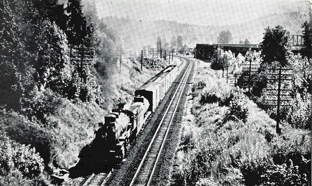
Looking south from the 1919 bridge over the tunnel portal
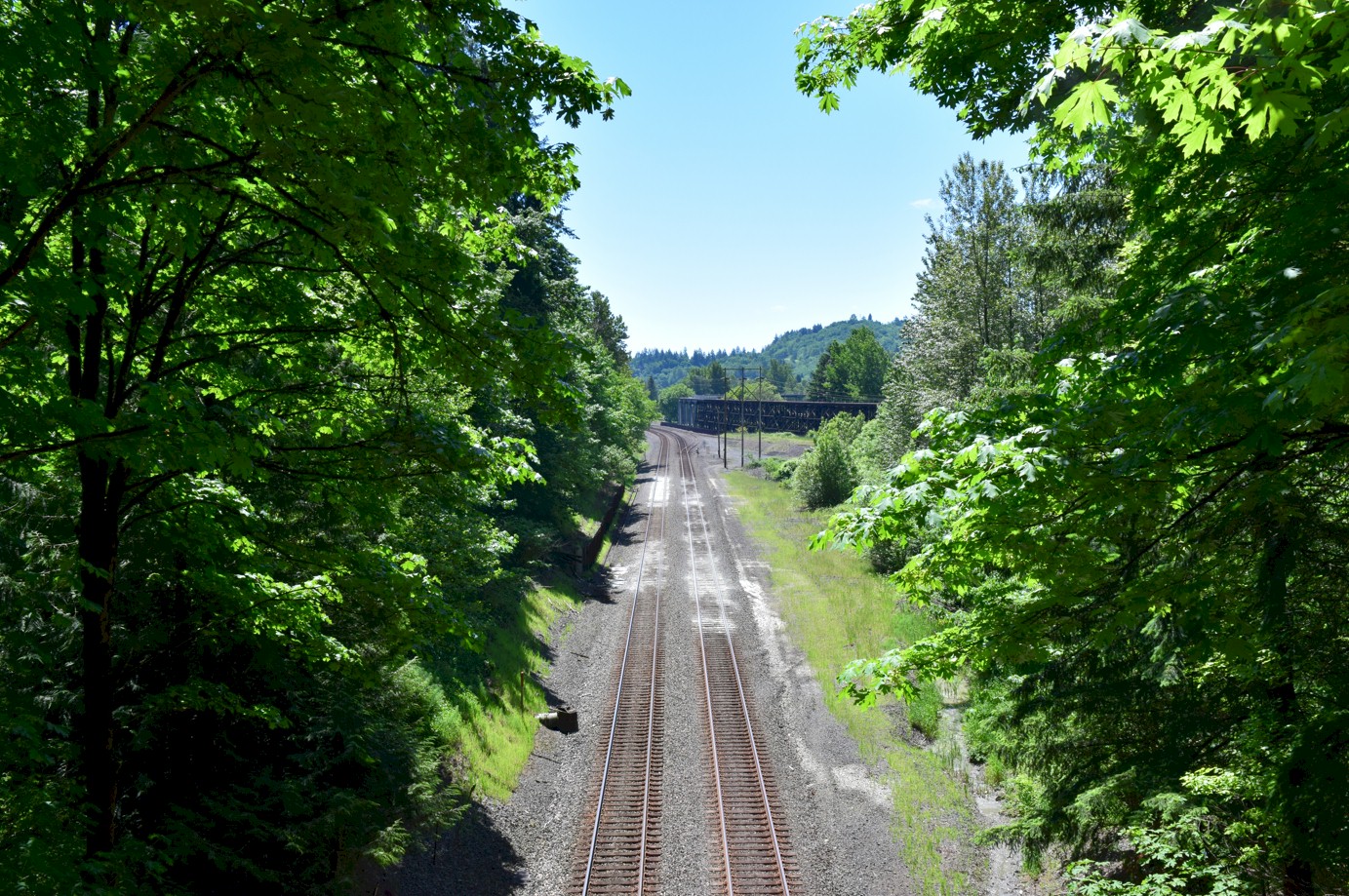
Same spot as the above photo, which was taken on May 28, 2020.
1919 map 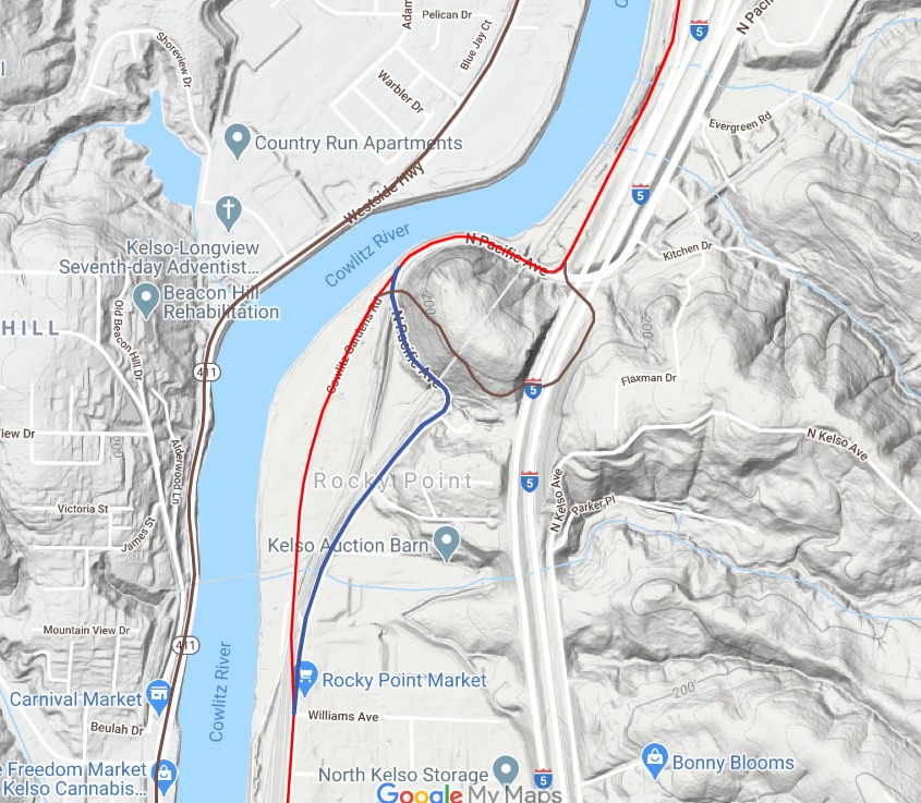
2020 map. Brown line is the old wagon road, red line is the early highway, and the blue line is the completed 1920 highway. 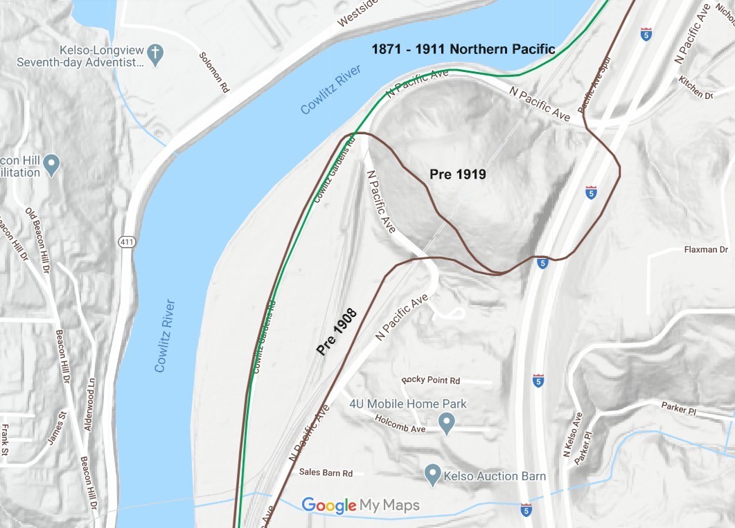
2020 map showing Rocky Point before the tunnel was built in 1911. 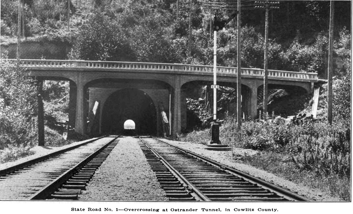
The double tracks and the new 1924 north portal bridge. |