![]()
The Historic Pacific Highway
in Washington
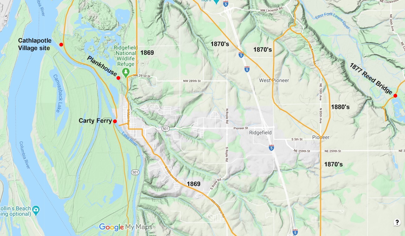
The Lake River Crossing
![]()
The Historic Pacific Highway
in Washington
The Lake River Crossing
The Lake River Country
By Curt Cunningham
The Lake River crossing was located at the town of Ridgefield, which is about 15 miles northwest of Vancouver. Ridgefield is at the north end of the Lake River country, which is a large agricultural area and home to the Ridgefield National Wildlife Refuge. The following paragraph is an account of the Lake River country written by a traveler in 1877;
"The road from Mr. George Lindsley's to Lake River is muddy, but our horses trotted along briskly for an hour, when, from the summit of a hill, we obtained a fine view of the Lake river country which, at this season, has an abundance of water. The grass on the bottoms is green, the cottonwoods ditto, the Columbia, full to the brim, winds away northwest, with St. Helens and Columbia City in the distance. The cozy homes of the farmers, dotted here and there, and the herds luxuriating on the tender grass, altogether constitute a beautiful picture of rural peace and loveliness."
The Chinook Nation
The Lake River country is bottom land that is nourished by the Columbia river. The Chinook people have also been nourished by the Columbia river. For thousands of years they had villages stretching eastward from its mouth, all the way to the Dalles. There were over 50 villages along the Columbia, Willamette, and on the coast from Bay Center in Washington to Seaside in Oregon. On the Willamette, they had villages as far south as Oregon City.
There were 16 principle villages in the Lake River country, 12 were on the Oregon side and 4 were on the Washington side. Cathlahaws was just north of Columbia City, Cathlapotle was located north of the mouth of Lake River, Nayaguguwikh was located where St. Helens is today, and the village of Scappoose was just south St. Helens. The villages on the west side of Sauvie's island were; Cathlanaminimin, Claninata, Gatlanakwaikh, Cathlacommahtup, Nemalquinner, and Gatlawakshin. The villages at the mouth of Lake River, and on the eastern side of Sauvie's island, and at Lake Vancouver were; Namuwitk Clannahquah Multnomah Wakanasisi and Shoto.
The plank houses they lived in were central to their daily life. Some villages were small, consisting of about a 100 people living in a single multifamily house with connected units. Or they could be as large as 30 or 40 houses. At Cathlapotle in 1805, Lewis and Clark saw 14 houses paralleling the channel, and estimated the population to be about 900 people. Archeological digs at Cathlapotle revealed 6 plank houses, with 4 of them divided into smaller units, plus several outbuildings and temporary structures. Sometimes the homes would be arranged in clusters.
Villages were linked through marriage and each village was basically a group of relatives. Marriage partners, who were usually the women, came from other places. These marriage ties facilitated travel between the villages. The size and population of the villages would vary seasonally. During the stormy weather of winter, people living along the coast moved inland, and in the spring they would move back to the coast. After Fort Astoria was built in 1811, the villages on that part on the river became inhabited year round as the center of activity was now around the trading post. Later when Fort Vancouver was established in the 1820's, the Chinook would come to the Fort to trade as other tribes from all over the Pacific Northwest did. The Columbia river was a busy place with canoes loaded with people and supplies going upstream and downstream all the time.
During the 1830's a deadly virus spread through the Lower Columbia and Willamette valley. This virus decimated 90% the Chinook people, plus many from the Lower Cowlitz tribe. The illness was originally called "ague and fever," and later, "intermittent fever," though it has been found that the virus was malaria. Before the illness struck, there were about 40,000 people living in the Chinook territory. After the sickness had passed, the population was approximately 2,100.
The Chinook never signed a treaty nor did they cede their land. In the 1920's the Chinook came together and wrote a constitution. They then set up an elected form of government and began to revive their tribal culture. In 1997, the Chinook sought recognition from the Federal government but were denied. In 2001, the U.S. Department of Interior recognized the Chinook Indian Nation, as a confederation composed of the Cathlamet, Clatsop, Lower Chinook, Wahkiakum and Willapa bands. In 2002, the recognition would be revoked.
In 2005, a 37x78 foot replica of a Chinook Cathlapotle Plankhouse was erected. The plankhouse today serves as a classroom for people to learn about the natural and cultural heritage of the area. The plankhouse is located at the Ridgefield Wildlife Refuge that was established in 1965. The refuge covers over 5,000 acres of flood plain habitat, seasonal and permanent wetlands, along with agricultural lands. The refuge was once part of the land claimed by the Hudson's Bay Company from 1825 to 1860, when they were forced to sell all of their remaining property below the 49th parallel to the United States.
Today the Chinook have a population of over 3,000, who mostly live near the mouth of the Columbia river. They have ceded their territory east of Oak Point. The Chinook Nation is made up of the; Kathlamet, Clatsop, Lower Chinook, Wahkiakum and Willapa bands. They participate in events throughout the region, and hold an annual Winter Gathering in the plankhouse at Ridgefield, and on the Columbia at Chinook point where Fort Columbia is located, near the town of Chinook, is the annual First Salmon Ceremony. Today in 2021, the Chinook have not ceded anymore of their land, and are still not a federally recognized tribe.
The First Settlers
In 1839,newly retired Hudson's Bay Company employee James Carty, decided to live out the remainder of his life at the Lake River crossing and built a cabin and started a farm. Carty was the only European living in the area until 1849 when 3 single men, Hendrick, Teal and Thing arrived and settled on what is now known as Bachelors Island.
In 1851, Carty was issued a license to operate a ferry across the Lake River. In 1852, Arthur Quigley arrived and a year later Frederick Shobert arrived. These settlers both took claims to the south of Carty's place. Not long after, they both built mud landings on the riverbank, so the steamers could make a stop to load and unload people and cargo. The place soon became known as Shobert's Landing or Quigley's Landing depending on who you asked.
The First Road to the Lake River Country
The crossing of Lake River was the first obstacle overland travelers faced on the road after leaving Fort Vancouver. Before the Americans arrived, The Hudson's Bay Company moved animals up this trail in the 1840's, when they were transferring them to the Lewis river pastures and at the Cowlitz farm. Most of the traffic in the 1850's were emigrants driving their stock north to meet the rest of their family at the Cowlitz Landing. The trail extended up the east side of the Cowlitz river. It was said that the farmer and his animals arrived at the landing before the canoes did. Later farmers who settled in the Lake River country would use this road to bring their produce to market.
The road ran through 23 miles of mosquito infested, swampy bottom land. Then it was 15 miles over mountainous terrain on a trail barely wide enough for a wagon. This was the least used portion on the entire route to Steilacoom. The Military never expended any funds for construction or improvement on this section. The county would later provide some assistance.
In 1862, Arthur Quigley was authorized by the Legislature, to construct and maintain a toll bridge across Lake River, near his house. The rates for crossing were; a footman 10 cents; for a man and horse 25 cents; for a horse and vehicle 50 cents; for one yoke of cattle, or span of horses, and wagon 50 cents; for each additional span of horses, or oxen 25 cents; for loose stock, 5 cents each. I do not believe this bridge was ever built as Carty was still running his ferry in 1864.
The road from Vancouver to the Lake River crossing was so bad that most of the traffic coming north from Portland would take the wagon road going north on the Oregon side of the Columbia to St. Helens and Rainier. Once there, they would hire canoes to take them across the Columbia and up the Cowlitz river to Monticello. At Monticello, travelers would take another canoe up the Cowlitz river to the Landing. After 1860, travelers had the option of a canoe of a stagecoach. In the mid 1860's, steamers took the place of the canoe.
In the fall of 1852, Edward J. Allen, who was one of the builders of the Naches Trail, landed at Fort Vancouver and described his journey on the trail to Monticello. “Winding through the woods and wet underbrush, following a trail not as plain as a cow path, which we wandered along having to frequently brush the moss off the pines so we could find the old blaze, it was no cheering work. After a harrowing crossing of the swollen Cowlitz, the party reached the flourishing town of Monticello, consisting of 4 houses. As we ate our breakfast, we listened to the often repeated tales of the horrible prospect we had ahead of us.”
In 1864, House Bill 42 was approved and funds were allocated for improvement of the Territorial Road between Vancouver and Carty’s ferry at Quigley’s landing on Lake River. Many Civil War veterans who emigrated to the Washington Territory after the war, found work on these road construction projects. The improvements to the road didn't help much and by 1866, the road between Vancouver and Lake River had become almost impassable.
On September 22, 1866, the citizens of the Lake River country had grown tried of the bad roads through their area. They wanted the authorities to consider improving the road leading from Vancouver to Lake River by way of Salmon creek. Jonathan Grant said to the Vancouver Independent that; "not a week had passed since the high water, when about a half dozen families arrived fresh off the Oregon Trail. These families all wanted to settle near Union Ridge, (Ridgefield) but many became sick of the mosquitoes of Sauvie's island, and other places in Lake River country where the land is destroyed year after year by the high water."
Grant then said that the road to Lake River country had been around for some years and was in need of repairs. Wagons could not pass over it without much difficulty. The farmers had tried to improve the road but it wasn't enough, and the citizens of Vancouver were not interested in it. Because the road was nearly impassible, the farmers had to haul their produce to the river, and run the risk of finding some skiff or canoe to take them across to St. Helens, or against the strong current up to Portland.
"The farmer wants to hitch up the family team bright and early in the morning, and with his wife, drive to Vancouver, on a good and pleasant road to sell his produce, and then purchase, coffee, sugar, tea and other articles for the household and the babies, and then return that evening." He finished by saying that if there wasn't enough public money to repair the road to Salmon creek that the business interests should chip in and help as it would be a permanent benefit to all the people.
It would take 4 years for Grant's idea to come to fruition, as in 1869, the muddy road along the river between Vancouver and Lake River would be bypassed by a Military road. This new route began on Main Street in Vancouver and traveled north to Salmon creek, and then to the Baker settlement, which was located at the intersection of NE 10th Avenue and NE 179th Street. (This new road from Main Street to NE 10th Avenue will become a part of the Pacific Highway in 1913, and today is called Hazel Dell Avenue.)
From the village of Baker, the road continued in a northwest direction connecting to NW Hillhurst Road, as it continued down the hill into Ridgefield. At Ridgefield, the new route continued north on Main Street to NE 71st Avenue passing the old residence of Columbia Lancaster, where it then followed along the river bank to the Davis ferry. The road would become known as the Ridgefield Road, the Road to Lewis river and the Government Road.
Quigley's Landing becomes a Center of Commerce
During the 1860's, Quigley's landing became a trading and supply center for the Lake River country. In the 1870's, the steamers Modoc, Peerless and Rescue, were some of the vessels that made regular stops. During November of 1875, a local resident wrote about a trip down the Columbia on the steamer Rescue, that was owned by the Kellogg Steamship Company;
"Captain Joseph Kellogg and his son Charlie, the purser, are polite and obliging men, and their boat is popular with the traveling public, especially with the farmers and ranchmen of Lewis and Lake Rivers. On this occasion she was loaded down to the guards with flour, groceries, cattle, etc, and had a goodly list of passengers, bound to eat Thanksgiving dinner at home. We steamed slowly down the river without incident worthy of note, and at last moored alongside the Peerless, a small craft tied up to the cottonwoods at the mouth of Lake River. From this point St. Helens is in sight only two miles down and across the Columbia, and, impatient of delay, we hailed a passing rowboat, whose occupant proved to be none other than our old friend Mr. Teal, of Lake River, who kindly gave us a seat with him, and to the music of the splashing oars we glided quickly over to the objective point of our travels."
By the mid 1860's, there were enough people living in the area that a post office was established on November 19, 1865, with Asa Richardson as the postmaster. The name Union Ridge was chosen for the post. This was because many of the residents in the area were veterans of the Union Army. Soon a small village would develop around the post office.
When the East Fork of the Lewis River was too low for the steamers to reach La Center, some of the farmers and merchants used teamsters to get supplies in to La Center and produce out to the steamers on the Ridgefield Road that ran between Ridgefield and La Center. During those years, this road was the most traveled in all of Clark county.
On September 4, 1877, a traveler to Union Ridge, as the place was now being called, gave her account of the town in the 1870's; "It was our good fortune to have the pleasure of a trip to Union Ridge last Saturday. Riding over the quiet roads through the woods is a very pleasant pastime, provided one is well mounted. The dust had been well laid in the roads and washed from the trees and brush which line the road sides."
"The smoke which had so long prevailed had disappeared, and in its place, was the clear atmosphere, bracing and healthful; upon the vegetation the first hints of Autumn, were visible, and the lonesome cricket chirped from his home among the leaves. Two miles and a half north of Vancouver we pass Alki, where the lamented Schaeben once designed to found a suburb, the "bye and bye," of which, as the name indicates, is farther off to-day than it was six years ago. Passing over the Tenney bridge we come to the worst hill on the road to Lewis River. Sand ten inches deep, it is impossible for a loaded wagon to pass up with less than three or four span of horses to draw it."
"It is a pity this road cannot be put in decent traveling condition. Will the people of Vancouver expect the people of Lewis River to market their produce and do their trading at Vancouver with such roads as are provided between the two points? This hill should have the attention of the Supervisor. Being of a sandy character, the rains may improve it, but some work could be done there to advantage, at least so says a farmer who has had occasion to pass that way several times lately."
"Passing through the purling waters of Salmon Creek, the road narrows and the trees grow so tall and thick as to render the ride almost oppressively lonely. You are thankful for an occasional stray sign of life, as the whirr of a partridge or quail, or the startled cry of the bright eyed squirrel as he leaps to the side of his guardian tree by the road. For six or seven miles the road winds along and not a habitation is to be seen, and then comes Union Ridge, fifteen miles north of Vancouver."
"This is the name given to this section of the county, but originally only meant a small ridge lying between Lake river and a small creek known as Gee creek. It was first called Union Ridge during the Rebellion, because all the settlers, save one were outspoken Union men. Hines' Chapel, the building of the Methodist Church, dedicated to that eloquent teacher Harvey K. Hines is the rallying point of the neighborhood."
"If in Union there is strength, this community is well named, for they are well united in efforts for the promotion of temperance and good morals. Among the many industrious and reliable citizens mentioned may be made of Lindley Meeker, H. H. Burr, Esquire Spencer and the family of the late Rev. Mr. Rounds. A good school is taught there by Miss Rounds. A Lodge of Good Templars constitutes a nucleus for the promotion of unity and good feeling among all the young people."
"Originally all timber land, a great deal has been burnt off and cleared and the new houses scattered here and there with the substantial barns and other improvements indicate how mother earth has rewarded the hand of toil. The crops are good, fruit is plenty, and but little, if any, sickness prevails. The rain had not done any damage, but some apprehension was entertained, if the showers should continue."
"After a pleasant visit, we turned reluctantly away from this rural district and headed for Vancouver. Riding through the somber forests, many were the thoughts of the simple wants, humble ambitions and quiet repose of these happy farmers. Bank futures do not trouble them, Ophir and Central Pacific Stock may be worth one dollar, or one thousand dollars per share, but it is all the same to them, they depend upon the honest hand of toil, have no failures, sleep soundly, and glide peacefully down the river of life without a riffle to disturb its quietude. We arrived at home at dusk, tired, but recreated and resolved to go again and take some friends next year."
Leaving your Husband in the Old Log Cabin at Union Ridge
On July 6, 1877 the New Northwest printed a story of a woman who lived at Union Ridge and fled her abusive husband. The paper discussed the old custom of wife ownership and that the practice was slowly being frowned on by the public, though not fast enough. They said that; "We find in an old, old paper, bearing the date of January 4, 1800, the following; 'Second notice of my wife Hannah is hereby given, forbidding all persons from harboring or keeping her, and from trusting her on my account.' This was duly signed by Matys Van Steenbergh, and reading it over and contemplating even in imagination the grim and surly Dutchman with the law, the power and the public sentiment all on his side, we wonder how poor Hannah could dare to leave him, even while we shudder at the thoughts of her staying with him."
"At that period in our nation's history the wife was a man's property. No person dared to 'harbor or keep her' when, fleeing for her life from her irate lord, when she sought shelter and bread elsewhere. Law and custom alike held her in bondage. Even though attitudes about wife ownership were beginning to change in the 1870's, there were husbands that still held on to this terrible custom. But the difference now was that 'Hannah' could return to her father's house in security and reside there in peace, ask 'trust' of no one, and go to work for herself. Plus the woman could now publish a rebuke to her husband and tell her side of the story."
These advertisements by abusive husbands were not uncommon back then, as were the rebukes make by the wives. On June 16, 1877, James Campbell of Union Ridge placed one of these notices in the paper that read; "my wife, Mary Campbell, without any cause or provocation left my bed and board and abandoned her home on Lake River in Clark county. She willfully remains absent from me, and, contrary to my most earnest protests, is staying in or about the city of Portland. This is to notify all persons not to harbor or contract any debts on my account, as I will hereafter pay no debt contracted with her or anyone else on my credit, except on my written order."
Could you imagine the look on Campbell's face when he read the notice placed in the paper by his wife. It reads; "One J. H. Campbell publishes me as having 'left his bed and board without cause or provocation.' If beating a man's wife with his fist, whipping her with a gunstlck, breaking a broom handle over her shoulders, beating her with a club, and for long years heaping curses and the coarsest abuse upon her, which renders life a burden, is no just cause for seeking happiness elsewhere than in my 'old log cabin at Union Ridge,' then call it an unjust cause, and make the most of it."
The paper ended the story with; "Truly, it is an easy thing for a man to write himself down a tyrant and an imbecile, and we trust that, having done so, this one will now sleep at ease in his wife's 'old log cabin at Union Ridge,' while, she, 'seeking happiness elsewhere,' will find it unaccompanied by gunsticks, fists, clubs, broomsticks, and curses."
Tragedy on Union Ridge
On Friday January 9, 1880, a tornado swept through Ridgefield destroying barns and fences it its path. D. H. Lambert lost his best cow in the fallen timber and George Lindsley lost his fences and J. Rathburn also lost his fences and had the roof of his barn blown off. Farmer A. Mc Andrews escaped with little damage. Mr. Bouge almost lost a cow when a limb fell peeling her back bone. There were 25 trees that fell over the road in a space of less than a half mile.
Commissioner Meeker told about the children of the Bartlett school house who were eating lunch when the storm came through, and a large tree came crashing down and killed 2 of J. Bartlett's children and wounding everyone else except for one child. Mr. Hine's barn was blown away and a barn was lost over at Pekin. Luckily the farmer was able to get his cows out of the barn before it collapsed. There was a man traveling on the road and when the storm came, he hid in a chicken coop that was lifted by the tornado leaving him sitting on the ground.
Some Union Ridge News Items of the Late 1800's
In the summer of 1878 the La Center owned Latona was launched and began to make runs between La Center and Portland. The lumber to build the steamer was made at a floating sawmill located at the mouth of Lake River at Union Ridge and was owned by Mr. Perkins.
In October of 1880, M. B. Jones built a large store building. On June 6, 1882, J. J. Tompkins of Portland moved to Union Ridge and opened a store with Stephen Shobert. On June 22, 1882, the Latona delivered Tompkins merchandise for his store at Union Ridge.
On July 9, 1882, the Union Ridge Presbyterian Church was established by Dr. Aaron Ladner Lindsley. The church was affiliated with the Presbytery of Puget Sound.
On August 6, 1882, Union Ridge residents William Wandall, his wife Mary and their freind Polly Adell Laws, who was the daughter of Frederick Shobert, went out to pick blackberries. After filling several buckets they were set under a bridge for safe keeping, while the party went to inspect another patch. On their return they found the buckets empty, but full of hair from a bear's cheeks, who seemed to prefer berries picked, to berries on the bushes. The bear had left in just in time to escape the wrath of the women.
Union Ridge on November 23, 1882; William Wandall was still in the wood business. There was a grand ball at J. Banzer's on the 3rd. Steve Shobert was building a addition to his store plus a new wharf. Everyone had fun at the apple paring recently held at Mc Andrew's. F. Young had been planting fruit trees that he purchased from Mr. Cook in Vancouver. "The next thing we hear of will be a paring at Young's, of some kind of fruit." A grand surprise birthday party was thrown for Polly Adell Laws, wife of Andrew Jackson Laws. It was said to have been the best party of the season. Friends began to gather at 10am, till the house was filled to overflowing. At 2pm, they were ushered into the dining room for dinner, which was excellent. The large birthday cake was presented by Mary Wandell formerly Mary Laws. It was a grand occasion and everyone had a great time.
On February 18, 1883, a road was proposed from Shobert's store to the the landing at Lake River. Arthur Quigley made a claim for damages that was to be determined later. On August 16, 1883, the road from Shobert's store to the landing was made a public highway. Quigley was paid for damages.
On March 1, 1883, Steven Shobert had completed building a wharf at Union Ridge that was 100 feet long and 50 feet wide. Afterwards he began laying out the Union Ridge town site.
On March 30, 1883, The Vancouver Independent said that; "George Lindsley of Union Ridge smole his largest smile in his office on Monday.
In 1883, the Northern Pacific built a spur line from Kalama, south through Ridgefield to Vancouver. Trains would have to travel back to Kalama and cross the river before going south toward Portland. The bridge over the Columbia would not be constructed until 1908.
By the mid 1880's the main trunk wagon road north from Vancouver had shifted east to Pioneer and the Pekin Ferry Road bypassing Ridgefield. That didn't hamper the growth of the town since they were vital to the region because of their wharf. Farmers were dependent on Union Ridge to get their produce to the markets in Portland. La Center also depended on the wharf at Union Ridge when the East Fork was too low for steamers to reach it. Some merchants used teamsters to haul supplies between Union Ridge and La Center. The Finnegan brothers were some of the teamsters who ran loaded freight wagons on the Ridgefield Road.
At the end of the 1870's and into the 1880's, dairy farmers in the Lake River country were becoming some of the most successful in the region. Captain D. R. Fales reported in 1878 that the dairy business was increasing and the quality of the products were superior. Fales owned 40 cows that year that were turning out 50 pounds of cheese a day. The dairy farmers were overshadowing the grain growers during that time.
The first creamery in Washington opened in 1886 at Ridgefield. Some of the big dairy farmers of the 1880's were; the Fales' dairy, the Lindsley brother's dairy, D. K. Abrams' dairy, and J. B. Knapp's dairy. Farmer Knapp had a large herd of dairy cows, and during the summer of 1888 each cow was giving 5 gallons of milk each day.
Addison Alexander Lindsley and his brother George Lewellyn Lindsley, the sons of Rev. Aaron Ladner Lindsley, were running the largest dairy farm in the Territory in 1888. The Lindsley brothers operated the first steam powered dairy in Clark county. They used the pasture land of Columbia Lancaster for their Jersey cows, that were the first herd of registered Jersey cattle introduced in the state. Sadly on August 9, 1891, Aaron Lindsley, who was a Presbyterian pastor from Portland, was killed at Union Ridge when he was thrown from a runaway carriage.
Union Ridge becomes Ridgefield
On June 17, 1890, the new postmaster who happened to be from Virginia, objected to the name Union Ridge and petitioned to change it. The postmaster won his petition and the town became known as Ridgefield.
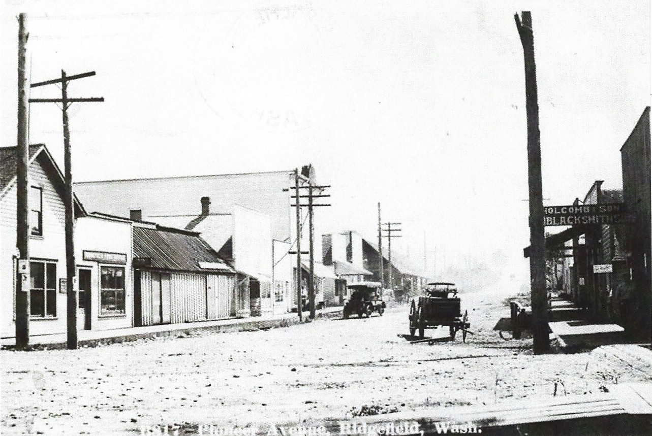
On November 25, 1906, a trio of crooks crawled through a window of Blackburn & Burrow's general store in Ridgefield at 3am. They unlocked the door and rolled a 700 pound safe, 2 and a half blocks down the street into a cut. There they punched off the combination, and blew the safe open. They got away with $300 in cash but left the firm's important papers intact. The thieves were never found.
On October 20, 1907, Albert and Alvira Bush who lived on their Fruit ranch in Felida, celebrated their 69th wedding anniversary. The couple were married on April 5, 1838.
On October 3, 1908, Anna E. Carty, wife of James Carty filed for divorce. It was the only legal way for her to secure a division of their property. The Carty's had 310 acres at Ridgefield and 4 valuable lots in Portland. James had grown cranky and stubborn in his later years and his 14 year old son William Carty was the only one he would talk to. Carty was going to give the entire property to his son, which forced the divorce.
In 1908, the Northern Pacific completed its bridge over the Columbia river. Ridgefield and Vancouver were now served direct from Portland. The steamers would now have to compete with the railroad for the traffic of the Lake River country, and from La Center, Yacolt, and Battle Ground. Stages would run between these points bringing passengers to the train at Ridgefield. The steamer era would now begin to decline and service would be discontinued at Ridgefield and Woodland by the mid teens and at La Center in 1931.
At the beginning of 1909, a terrible winter storm dumped almost 2 feet of snow. At Ridgefield, Lake River was frozen over and all traffic by water between Portland and Ridgefield had stopped. La Center and Woodland were also cutoff.
On May 29, 1909, Ridgefield was a busy place. Will Morris a painter and decorator from Vancouver and a brother of Mrs. E. A. Blackmore of Ridgefield, brought with him a group of painters and began to improve the town's appearance. They had just completed painting the inside of the Ridgefield Mercantile company's store, Mr. Blackstone's house, and the residence of Mr. Kern. The painters then went over to the I. O. O. F. hall, and after that they went over to Mr. Hale's home that was recently built on Lindsley Avenue. Mrs. Mary Hylan completed a 2 story residence at the foot of Maple Avenue. John Hylan built another building on an adjoining lot. L. D. Pettys moved to Ridgefield from Vancouver and purchased a lot from Mr. Blackstone and build a home on it.
Also on May 29th, the young ladies of Ridgefield organized a basketball team for outdoor basketball during the summer, and appeared that day at the park for their first game. Grace Thomas and Gladys Hughes were forwards, Greta Schubert and Mattie Marquis were the centers, Mary Murray and Rets Schubert were the guards. They sent an open challenge to any team in the adjoining counties who were organized for outdoor games.
On June 3, 1909, Manager Forbes of Ridgefield's baseball team arranged a game with St. Helens. The game was excepted to be very close as both teams were strong. Also that day the Hotel Ridgefield was kept busy at the noon hour serving over 50 extra dinners to the gang that was constructing the abutments along the Northern Pacific's tracks just south of Ridgefield. And James Carty rented out his farm south of Ridgefield that was known as the Blackwater ranch.
In 1909 Ridgefield became a large strawberry producer. There were a number of strawberry patches in the area producing over $500 an acre. On June 20, 1909, specimens brought to Vancouver required only 5 berries placed in a row to measure over a foot long. In a field belonging to Mr. A. P. Lyons $54 worth of berries were picked from an acre and there were more to be picked. One plant had over 158 berries in different stages of maturity. The Independent then said; "Every night train for Seattle carries a carload of Ridgefield berries. More interest is being shown in strawberry culture in and around Ridgefield than has ever been shown in agriculture. Ridgefield people claim their soil will produce and is producing the best strawberries in the world."
On August 5, 1909, Ridgefield was preparing to vote on incorporation. There seemed to be no opposition and the petition had been signed by 313 residents of town, though only 300 were needed. The citizens of Ridgefield unanimously decided to elect James A. Smith as the first mayor. Smith was also the president of the Ridgefield Commercial club. In 1909 outside of Vancouver, Camas, Yacolt and Washougal were the only towns incorporated in Clark county at the time.
On August 16, 1909, at a mass meeting in Ridgefield, the residents nominated election officers for the town's incorporation vote. Though there was no ill-feelings, the contest was "waxed warm." E. A. Blackmore called the meeting to order, and county commissioner F. C. Smith was chosen temporary chairman, and A. C. Allen clerk. J. W. Blackburn then made a motion to make the officers permanent. James Smith was nominated for mayor, and the following were nominated for the city council; 1st Ward, G. H. Gilbert; 2nd Ward, R. S. Stryker; 3rd Ward, Smith Maxon; 4th Ward, A. Murray; 5th Ward, N. C. Hall; treasurer, E. A. Blackmore. The vote was held on August 20th, and the city of Ridgefield was incorporated on August 26, 1909.
On April 20, 1910, the Ridgefield Fruit Growers' Association was organized. The following officers were elected; President, D. F. Leach; vice president, George J. Stanley; secretary, George W. Buker; treasurer, A. P. Lyons. It was decided that all fruit packers would be hired by the association and be responsible for the neatness and quality of the packaging. They were expecting a large crop that summer to help promote their business.
The Amorous Preacher gets Clobbered
On a pleasant Saturday afternoon in Ridgefield on May 14, 1910, Reverend Charles M. Smyth, the Methodist minister at Pioneer was hit over the head with a club when he was walking down Main Street. The clubber was Marion Lane, whose daughter it was generally believed, was engaged to the preacher. Rev. Smyth had been paying much attention to Miss Lane for some time. It was soon found that Rev. Smyth had deserted a wife in the east, as the fact came to light when he was served with divorce papers.
To make matters worse the preacher announced from the pulpit that he never had any intention of marrying Miss Lane. When the mother found out about what the preacher had said, she became furious and went to get her son-in-law, Rock Soden. The duo then proceeded to town where they met the preacher in the middle of Main Street. The son-in-law grabbed the preacher and held his hands behind him while the irate mother gave him a good cudgeling on the head with a club. They were quickly arrested and fined $10 each by a justice of the peace, but they said it was worth it. A civil suit would be filed later.
Public sentiment was generally with the Lanes, who were leading people in town, though the preacher had a few sympathizers. The wounded minister was confined to his bed with bruises, and said he would start civil suits for damages when he gets up. On the other hand, it was reported that when he returned to Ridgefield he would be waited on by a committee and advised to leave town. Smyth was bed ridden for several weeks, suffering from a concussion. Mrs Lane said she chastised the minister because he treated her daughter poorly.
On July 6, 1910 Rev. Charles Smyth married Grace Converse, of Sara. Rev. Smyth had just resumed his duties as pastor of the Methodist church at Pioneer. Back in May when the reverend was hit by Marion Lane, he had said that he had no intentions of marrying anyone, although it was supposed he was engaged to Marion's daughter. This is what prompted Marion to club the Minister. Smyth filed suit prompting Marion Lane and her son-in-law Rock Soden to post $500 bonds, and await a trial for the assault on Reverend Smyth.
Those Big Hats of the Edwardian Era
During the Edwardian era women loved to wear large oversized hats. These hats would be adorned with bows, laces, plumes of feathers, flowers, and a light fabric called tulle. The items would be secured to the hat by using large pins. The hats were called Gainsborough or Picture hats because they framed a lady’s face. Coco Chanel called them, “bird nests.” In places like theatres and picture shows, the hats would be an annoyance to others as they would block their view.
Women who took stagecoaches to catch the train to Portland for high society events could not wear their big hats due to the limited space. Captain Horace Campbell who ran steamers between La Center and Portland came up with an idea that would allow the women to wear their big hats while traveling to Portland.
On February 14, 1911, an article in the Oregonian said that; "Maids and matrons of La Center and the neighboring hamlets, who pout because a short stage ride to the railroad at Ridgefield prevents them from wearing their big hats on visits to Portland, owing to the limited space in the vehicle, are encouraged to take the Charm. The largest Gainsborough's, picture hats and other creations may be accommodated aboard the Charm." Horace Campbell built the doors the same width, forward and aft. They were unusually wide, and a portion of the roof slid, to permit greater freedom of movement in boarding or leaving the craft."
"The entrance to a regular launch was not sufficiently wide for the large hats and Captain Campbell expected to carry many women passengers, is why the wide doors were adopted. The Charm docked regularly at the berth of the Yellow Stack Line at the foot of Taylor street, in Portland and making a trip between Portland and La Center every day. The Charm could carry 50 passengers and competed with the Northern Pacific, which had just completed the line between Portland and Kalama. The Charm was a passenger only vessel and carried no cargo."
Some Ridgefield News Items 1912 - 1914
On June 1, 1912, a chicken with 4 legs and 3 wings was hatched at a farm near Ridgefield. The bird was mounted and presented to the scientific society at Portland.
At noon on August 10, 1913, the 3-story Ridgefield Hotel caught fire and burnt to the ground. The owner F. A. Mc Cleary said that the fire must have started in the 3 floor chimney. Luckily most of the items except for some beds on the 3rd floor were removed before they were consumed in the flames.
In the spring of 1914, Ridgefield was experiencing an era pf prosperity. The H. J. Potter sawmill and J. L. Bratlie's shingle mill were running full blast every day along with the operations of the Lewis River Boom and Logging company. The Ridgefield creamery & cheese factory was at its full capacity. Additional machinery had to be brought in. The new Ridgefield Hotel was to be ready for business that summer, as the finishing touches were being made, and the structure was filled with quality furnishings for the times. And Virginia Fales had her residence remodeled with all the latest improvements and modern conveniences installed.
Also that year, Ridgefield was experiencing a boom for residential homes, and was starting to become a suburb of Vancouver. Every home that was built was quickly rented out. In February of 1914, there were no vacant homes. Because of the demand, many residents were building cottages to rent out. C. F. Brunkow built a home on 3rd Street, Thomas Rasmussen completed a fine residence on Main Street. The First Methodist Episcopal church on 4th Street built a residence for their pastor just north of the church, in the Lambert & Sargent Addition. E. A. Carlsen of Bachelor island purchased the old parsonage from the church. George Buker was the contractor for the new parsonage.
The Roads to Ridgefield are Improved
During the summer of 1915, the county was laying gravel on 2 miles of road between Sara and Ridgefield, and 2 miles between Knapps and Sara. This was to make it ready for heavy traffic when the Pacific Highway was closed for paving and improvement between Salmon creek and Pioneer.
On October 2, 1915, permanent highway No. 4 which is the road leading east from Ridgefield to Pioneer, was graded for a little over a mile toward Horn's Corner. Several cuts and fills were made to obtain a 6% grade. The new grade had a roadbed 24 feet wide with a 14 foot macadam center. The east end of the highway connected with the road through Horn's Corner and Crabb's Corner to the Pacific Highway. Horn's Corner is at the intersection of S. 65th Avenue and S. 5th Street, and Crabb's Corner was at the Pacific Highway intersection with S 5th Street, both in Pioneer.
On October 30, 1915, The new highway between Ridgefield and Pioneer called permanent highway No. 4 was completed and opened for traffic. The new grade through the canyon was on a large fill to lower the grade. Heavy guard rails were placed at the curves with a "safety first" idea carried out at all danger points. The road cost Clark county $10,000.
On June 4, 1916, the road leading south from Ridgefield to Bartel's Corner and Kelleway's Corner was graded and covered with crushed rock. This made the road between Ridgefield and Vancouver in good shape all year.
On June 30, 1916, a trio of thieves cut all the telephone wires leading out of Ridgefield. They then robbed the store, bound and gagged 2 citizens, drove others away at gunpoint, went over to the bank and proceeded to blast open the safe. When the attempt was unsuccessful, they fled town never to be seen again.
On June 21, 1919, Ridgefield's roads were to be covered with bitulithic paving. Pioneer Avenue, Main Street and Lake Street all were paved this way. The road between Ridgefield and Pioneer was also paved in bitulithic paving and connected to the concrete pavement of the Pacific Highway. This completed work made the road between Ridgefield and Vancouver a hard-surfaced paved highway.
Ridgefield Today
Today the suburbs of Vancouver and Ridgefield are beginning to merge together as the growth of Clark county continues. The area that was once a quiet farming community is fast becoming a residential suburban community. The Ilani casino is located at Ridgefield and has become one of the Northwest's premier gaming, dining, entertainment and meeting center. There is 100,000 square feet of gaming space and nearly 3,000 slots, and 75 gaming tables. Plus 15 different restaurants, bars and retail outlets. There is also a 2,500 seat meeting area and entertainment venue.