They are building a bridge that is more than a bridge
more than spans spun of steel inwrought with the genius and joy of men
more than piers set deep beneath the bed of the stream
where the current may lash and the winds vainly scream
it will be a broad road where never was a road
since summits were lifted and valleys were formed
since pioneers came and began their endeavor
it will join two cities where interests are one
will link two states and abolish the barrier that hindered their trade
will open the way to that long looked for day when commerce and friendliness
will be born by the bridge
Marshall N. Dana 1912
History of the Interstate
Bridge
By Curt Cunningham
The Columbia River
The Columbia River is a magnificent
scenic state boundary. It is also a formidable one. Since the first days of settlement in the Columbia basin, the sweep of the great
river has divided commercially the communities which are now called the Oregon and Washington
shores. For a generation, the people of both commonwealths have asked the
question; "When and how will this barrier to communication, traffic and commerce
between two states be blotted out?" The answer is, "By a highway
bridge!"
The Great River to the
West, known today as the Columbia River, divides the states of Washington and
Oregon from the Wallula Gap to the sea. What the Mississippi is to the Middle West and the South, the Nile to
Egypt, the Amazon to South America, the Columbia is to the Pacific Northwest.
The
waters of the entire northwest region, east of the Cascades, drain through a narrow channel in the
mountain range with such volume that, when the turbulent waters reach the ocean, they
can change its color for miles. It is the 2nd largest river in North America by the amount of water discharged from it’s mouth and the 4th largest river overall in North America. It begins its 1,240 mile long journey at Columbia Lake in southeastern British
Columbia and flows through the state of Washington before turning west to
the Pacific Ocean.
The Columbia River has served the people of the area as a transportation corridor for thousands of
years before the Europeans arrived and "discovered it."
The Chinook, who have lived along the river for centuries called it
hayásh-tsəq, which translates to "Great River."
The early European explorers have called the river by several different names.
The records are not clear
if the river was actually discovered before 1792 or if it was just presumed
to be there. The Spanish called it the “Rio de San Roque”, the “Rio de Aguilar,”
and the “Rio de Thegays.” The French, British and Americans called it the “Great River of the West,” and the “Oregon River.”
The earliest known European discovery of the mouth of the Columbia may have been made by
Spanish Explorer and Captain, Martin de Aguilar in 1603 as his ship sailed north along the west coast in search of the fabled “Straights of Anian,”
better known as the “Northwest Passage.” Beginning
in the late 14th century, and throughout the 15th century, the early European and Russian explorers searched in vain
for this passage. This mysterious trade route had been the subject of vague rumors and
wild tales told by ancient mariners
for many many years.
In 1775 Spanish Captain Bruno
Heceta sailed into the mouth, made an astronomical observation and gave names to the river, bay and the two capes, but these names never stuck. In 1788, British Captain John Meares sailed into the mouth and decided it
was not a river but instead a large bay. He was disappointed that he could not find the “great river” and left us with the name Cape Disappointment.
On May 11, 1792, American Captain Robert Gray
and his crew, sailed the ship Columbia into the mouth of the great
river and officially discovered it. Before they started back home they met
up with British Captain George Vancouver and told him of the river they
found. Captain Vancouver then sailed his ship the HMS Discovery into
it's mouth accompanied by the HMS Chatham. Vancouver then ordered the
Chatham to sail up the river. The explorers made it as far as Point
Vancouver about 110 miles upriver.
The river is very old, it is older than the Cascade mountain range. The mountains rose over the millions of years
as the river continued its journey to the sea. There was a time when the
river once flowed under a natural land bridge. Years later an earthquake or volcanic
eruption had occurred, which caused this natural land bridge to collapse
which blocked the river. This caused a large inland sea to develop behind the blockage which
covered most of Southeastern Washington. Over a long period of time as the water
level slowly rose, it reached a low spot in the blockage. This low spot
would eventually erode to a point where the water broke free and it caused a cataclysmic flood.
There is an old Indian tale of
this natural land bridge called “The Bridge of the
Gods.” This was said to be near where the bridge by the same name is now located. The old story goes;
that a long time ago there was no break in the chain of the Cascades between Washington and
Oregon and the Columbia flowed through a
subterranean tunnel in the mountains. Sometime later, Mount Rainier and
Mount
St. Helens got into a quarrel (erupted), and the ensuing struggle caused
this natural bridge to collapse and fall into the river blocking its path.
Many many years after
the fight had taken place, the blockage began to erode. Eventually the
weakest point gave way creating an epic flood. The flooding was so catastrophic that the
Willamette Valley was inundated with the flooding waters to a depth of 500
feet before the water could drain into the ocean. There is today scientific
evidence that this event had indeed occurred.
The Columbia River has a watershed of 345,000 square miles, which includes the western
slope of the Rocky Mountains, both slopes of the Bitterroots in the United States
and the Selkirks in British Columbia, both slopes of the Cascades, and both slopes of
the Coast Range.
It is probably the only river in the world which drains both slopes
of 3 ranges of mountains, cutting its way through them with resistless power
in its struggle to reach the ocean. Of its drainage area, 182,000 square miles are east
of the Cascades, an area equal to that of New England, New York, Pennsylvania,
New Jersey and Maryland combined.
The valley of the Columbia is the main artery of commerce for the
Portland-Vancouver region. Seagoing ships ascend the
Columbia to Vancouver, and
to reach Portland, 110 miles from the ocean, ships must sail up both the
Columbia and the Willamette rivers. The Columbia has 2,132 miles of the navigable
river including its tributaries. The river gives freshwater harbors to
Vancouver, Portland, Longview, and Kalama. The opportunity
to enter such a harbor is of great value to ships, for the action of the fresh water cleans all
the barnacles and other marine
growth from their bottoms.
But the Columbia also
serves as the
natural gateway for land transportation from the great agricultural regions
in the east. Its valley furnishes the only water-level route for a railroad
through the Cascade and Sierra Nevada Mountains between the Canadian and Mexican boundaries.
Portland and Vancouver are at the head of navigable water for seagoing ships in the Columbia
Basin and these towns are served by the Burlington Northern and Union Pacific railroads.
The Columbia River is a natural outlet
to the ocean for the commerce of the interior and is a natural inlet for imports
from abroad. The Columbia is the great river of the Pacific Coast, in volume and in commercial
value. It is second only to the Mississippi. Its banks are more stable, its waters are clearer,
its ice blockades are much less in duration than in the great waterway of the East. Unlike the Mississippi, the Columbia seeks the
ocean in a line parallel to trade channels, and not at right angles to them.
Crossing the Mighty
Columbia
In 1906, Ezra Meeker
retraced the Oregon Trail and drove his ox team back
over the route he had first traveled, in 1852. The old pioneer had also
passed over the trail in a high-powered automobile and had viewed the route
from above in an airplane. He made himself and the old road famous, and had urged
the Government to improve the pioneer route to the Pacific Northwest.
On all of his
trips except for the plane ride, Meeker crossed the Columbia River on a ferryboat, but
if he had set out again over the trail from Olympia to the Missouri River,
after 1917, he would have found the Vancouver ferry gone. Its place had been taken by a great steel
bridge. From around 1850 to 1917, Ferryboat Captain Frank Stevens, had crossed the
Columbia River on that ferry. First as a deck hand, he served on the combined sailing
scow and rowboat of the pioneer days. His father was captain and later young
Frank became the commander. Later a steamboat would succeed the scow and was in turn
succeeded by other steamers.
Captain Stevens served on all of them and was
in command of the City of Vancouver when that ferryboat sang its swan song
and retired before the Interstate bridge. Early in life the Citizens of
Vancouver, nestled alongside the river, dreamed a dream. They saw railroads and
docks along the river bank. Ships at her docks and bridges spanning the
mighty Columbia. But instead, the railroads passed her by,
and built a boomtown downstream at Kalama leaving Vancouver with her prune orchards, her vineyards on
the hillsides, her army post, and her pride of ancestry.
But dreams do
sometimes come true and Vancouver waited patiently. Then in 1907, came James
J. Hill, the empire builder, and the railway down the north bank. Next came a monster
$3,000,000 railway bridge. The Northern Pacific, Great Northern, North
Bank and Oregon & Washington trains arrived and crossed that bridge. Vancouver awoke and in her awakening set things in motion. If
railroads could build bridges for their use why couldn't the people build
bridges for theirs?
Committees were appointed, meetings were held, and the
city pleaded before the legislatures of Washington and Oregon for money with
which to build an interstate bridge. The legislatures listened and granted
the plea. The appropriations were attacked in the courts. Vancouver ceased
to plead and began to fight, and when the battle was won, the mayor and chief of police
went into hiding while the people blew the "lid sky high" and
celebrated.
On the streets of
Vancouver, a piano with a "bunch of live ones" were placed on a
horse drawn wagon and serenaded every prominent street corner. There was dancing in the
streets; fireworks and singing everywhere and then the celebrants crossed
the river with Captain Stevens and took Portland by storm. When the celebration
was over, the serious work of building the bridge began.
It was a
mighty undertaking, the building of this last link in the Pacific Highway
stretching from that younger Vancouver in British Columbia to the ancient
Spanish Town of San Diego in California. At last it was finished. It was
Vancouver's 1917 Valentine from the states of Washington and Oregon, a token
of love and a sign of respect for the city's 93 years. Again the
famous old town forgot her age and celebrated in a manner thoroughly
up-to-date. Today in 2020, the City of Vancouver is 170 years old and
Fort Vancouver, the old Hudson's Bay trading post is 25 years older. Even
older still are the tribes who have lived along its banks for longer than
anyone can remember.
Among the speakers was Sam Hill, good roads enthusiast, who said the bridge should
remain "open as long as the world shall last." Civilization began
its work in Western Washington at Vancouver, she is the Mother City of all
Washington cities, and it is fitting that this history close with the story
of the realization of her dreams.
The Ferry Boats
Before ferry service was
established between Portland and Vancouver, canoes and scows were used to
cross the river. The Chinook were the first to ferry passengers across and
later the Hudson's Bay Company would send their large canoes called "bateaux"
and scows with sails and oars to take people
and cargo across the river when it was needed.
On October 15, 1846, John Switzler was authorized to operate a ferry across the Columbia from his
claim which was located on the river bank at the extreme north end of old
Vancouver avenue. On the opposite side, the scow landed at the Hudson's Bay
wharf that was east of the bridge. In 1849, William Dillon established
a rowboat ferry service from Fort Vancouver to his property somewhere near
the mouth of the Willamette.
On March 13, 1879, Captain W. H. Foster of Portland was in the process of establishing a ferry across the Columbia. The landing was at the foot of "B" Street in Vancouver, near the old Alta Hotel, where a new wharf was built.
The new boat was finished in May of 1879 and was 80 feet by 22 feet in the hull, 7 feet in the hold and was 110 feet long and 35 feet wide on the deck.
The boat made about 10 trips back and forth each day as it took about an hour to
make the round trip voyage back then.
On March 22, 1883, the ferry
Albina began making regular trips on the same time schedule as they did the previous year. That day many carriages came over on the ferry
from Portland to take a tour through Vancouver to visit the garrison grounds. Jerome Smith commenced regular trips with the Vancouver-Portland stagecoach and made 2
trips a day until the
high water on the bottom land interfered with travel leading to the Oregon
ferry landing.
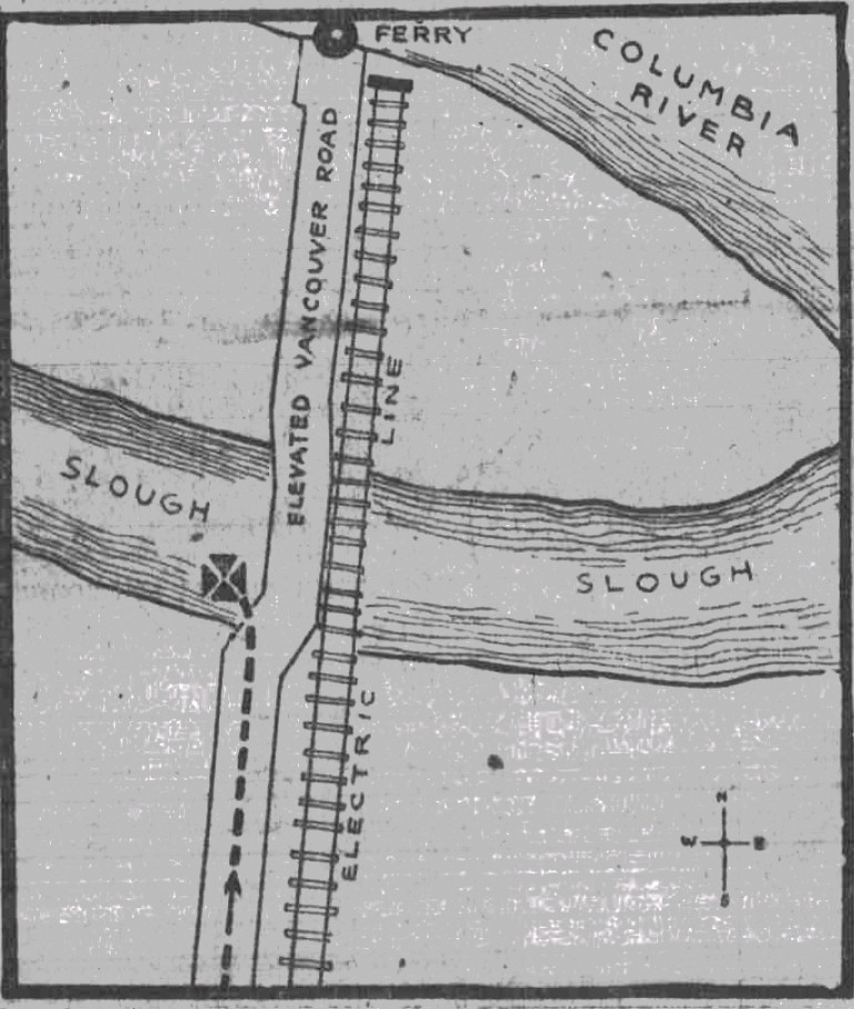
On the Oregon side, the
original ferry landing was on Vancouver avenue when it stretched northward
across the slough. The roadway was elevated across the bottom land to the
ferry dock. In 1911, the landing was moved downstream to where the
Interstate bridge will be built so to cut down transit times. Union Ave, now
called Martin Luther King Jr. Blvd. and Highway 99E were extended across the
bottoms on a trestle to the new ferry terminal. The trolleys ran on this
street to the ferry landing. Today you can still see some of the old piles
that carried so many people to the ferry terminal. The last ferry put into
service between Vancouver and Portland was the City of Vancouver with
Captain Stevens at the helm.
The Portland-Vancouver
Elevated Road
On August 25, 1875, the
idea of improving the Vancouver Road (now Vancouver avenue) between East Portland and
Switzler's ferry was introduced. The idea was to improve the muddy road
across the bottom to the Ferry Landing. As it was, during high water, the
road was impassible.
To accomplish this feat, it was found necessary to build a bridge
over 3,000 feet long, and to do a great deal of grading. The proposition was made
to the county authorities of Multnomah and if the county would pay for all the lumber
necessary to be used in the building of the structure, the needed funds to have the
work done would be raised by private subscription.
The new road was to be
elevated on a viaduct across the bottom land between the property of Lewis Love and
John Switzler. The long trestle was 18 feet wide and covered with 4 inch plank, spiked down
and had sufficient height above the high water mark. The county consented to
the proposal, with the understanding that the authorities would pay for half the lumber on
the completion of the bridge, and the remainder after the road had been graded and
improved to a certain extent expressed in the contract.
The Commissioners of Multnomah County proposed to furnish all the lumber and spikes
necessary, and that a call was made to Clark County to supply the labor. Subscription papers were
then prepared for circulation. The bridge was estimated to cost $10,000, which
Clark County ended up paying about 50% of the cost.
Construction of this bridge
was started at the end of 1879 or at the beginning of 1880. On March 18, 1880, the bridge bents were all in place and the roadway was
mostly graded. The viaduct was built by bridge builder A. S. Miller & Son of Portland, and
was 3,300 feet in length making it the longest bridge in Oregon at the time. The bridge deck
had a turn in the
center that was 24 feet wide. Captain Foster hauled all the lumber for the
bridge upstream on the Vancouver ferry from St. Helens and Rainier, free of charge.
On April 9, 1880, the
"Long Bridge" as it was known, was completed. The
ferry owners Foster & Willis had extended an invitation to the citizens of Vancouver who wanted to go see the
new bridge could make the trip across the river free of charge. Seemed like everyone wanted to see the new structure and the ferry made more than one trip taking a full load of
Vancouverites over to see the bridge. The Multnomah Commissioners also visited the bridge that day to inspect the
construction work.
On May 6, 1880, Judge Rice and the Multnomah County Commissioners Wilberg and Holbrook, made an official visit to inspect the Long Bridge.
On their examination it was found that the work had been done in a very thorough and satisfactory manner.
The citizens of both towns had realized the importance of a good
road between Portland and Vancouver, which could be passable at all times of the year.
After the bridge
was completed
and accepted by Judge Rice and the commissioners, the first installment was paid. When the necessary grading
work was finished the second installment was paid. The grading work was done by the soldiers who
were stationed at the Vancouver Barracks. When the road was completed, it was a delightful drive between the two cities.
On July 15, 1880, the
"Love bridge" over the Oregon slough on the Vancouver Road was damaged by
high water making it unsafe for travel. Joseph E. Smith was contracted to build a replacement bridge that was 500 feet long
over the slough, and was built as high as the Long bridge, for a cost of
$1,000.
Tragedy on the Trestle
On Friday June 10, 1910,
after darkness had settled down over the swift waters of the Oregon slough, the gruesome
work of dragging the riverbed for bodies was halted. The search team was
looking for an automobile with 2 occupants inside, who had sped to their death
in a mysterious red automobile that crashed through the barrier and drove off the high bridge.
The victims were; Mabel Monta and her driver, Jack "Frisco" Day.
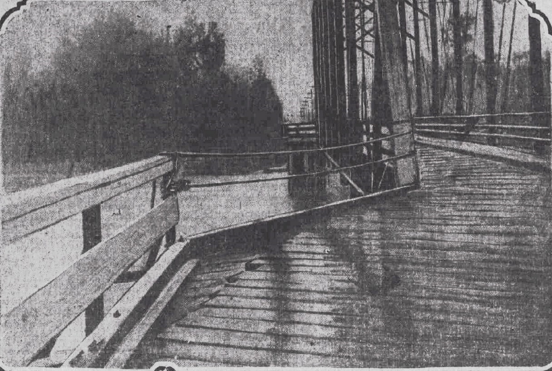
The elevated plank road over which the auto
had traveled, extended for a distance, of about 3/4ths of a mile in a straight
course to the ferry landing, and just before passing the bridge span over the deep water
of the slough, the bridge made a sharp turn to the right. The spot was a
potential death trap to drivers who were not acquainted with the bridge, or who approached
the bridge at a great speed. In the dark nothing would keep a car from going through
the railing and drivers had to proceed with great care. It was considered a wonder that accidents similar to
this one had not happened at this place before.
The Bridge is Born
On February 6, 1912, President
Lloyd Dubois of the Vancouver Commercial Club had named the following as a committee to
make recommendations for the construction of a bridge to span the Columbia
River at
Vancouver. The committee members were; James P. Stapleton, J. H. Elwell, Floyd Swan, H.
L. Moody, A. B. Eastham, A. M. Blaker, J. W. Shaw, Mayor C. S. Irwin, E. A.
Blackmore, L. F. Russell, O. A. Aagaard, E. L. French, O. J. Olson, Hugh
McMaster,
and J. A. Keaton.
The first unofficial meeting was held
at the commercial club rooms at 10am on the 6th, when Engineer Harrington of the Waddell & Harrington
Co., construction engineers, met with the committee to discuss the proposition.
J. H. Nolta, chairman of the Portland committee, recently appointed at Piedmont,
was also present. J. H. Harrington placed an estimate on the bridge of $1,500,000, and estimated
its length, at about 3,500 feet.
The engineer took the matter up with the
War Department
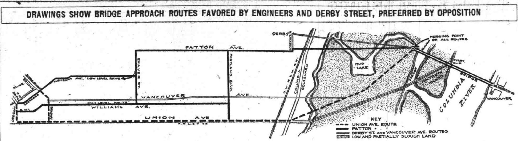
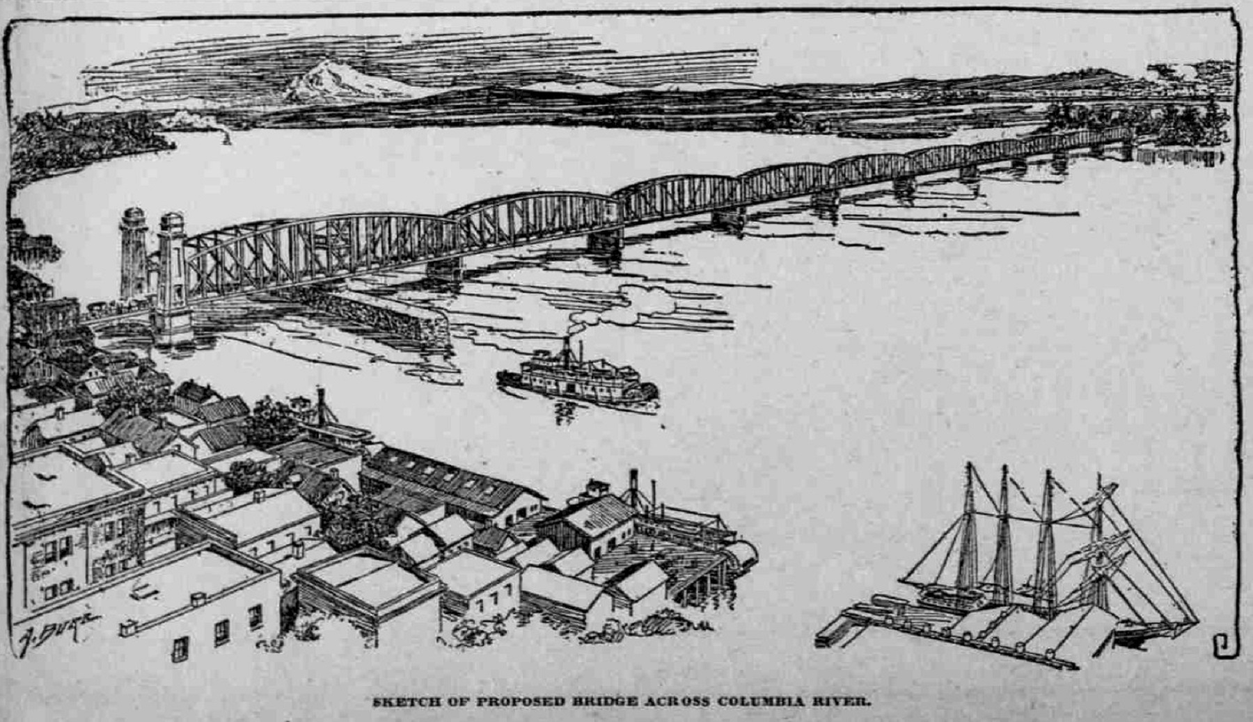
at Washington, and presented sketches of the proposed bridge. The location of the
span would be from the foot of Washington Street in Vancouver to a point a few hundred feet
west of the present ferry landing on the Oregon side, to connect with Patton avenue.
This route would intersect to the manufacturing district of Portland on the peninsula, and it
was contended to be
the route favored by President Josselyn of the Portland railway, which would operate its
trolley on this bridge.
Chairman Stapleton called a
meeting to devise plans to raise funds
for the survey, which had to be established before the legislature would be asked for an appropriation.
J. H. Nolta, S. L. Woodward, H. A. Ruble, and A. Donovan of Portland attended
the meeting.
On April 28, 1912,
preliminary surveys were made for the proposed bridge from Vancouver to Portland. Ralph Modjeskl, one of
the world's most renowned engineers at the time, arrived in the city and started
the work of arranging for river soundings. He announced that he believed the bridge
could be built for $2,000,000 or less. As soon as the preliminary work was finished, Mr. Modjeskl
said he would start drawing the preliminary plans for the structure in his main office
in Chicago.
Before the
bridge, the highway had terminated at the proposed approaches of the span on both sides of the Columbia. The
crossing by ferry, was a serious defect in the highway and it was proposed to raise the
money for the bridge by appropriation and not tax the public. The plan was to have the Legislatures
of Oregon and Washington contribute like amounts. It was thought probable the Federal Government
wood assist in the work, in which the cost to each of the states was
to be less than $1,000,000.
The soundings began in the
Spring of 1912, and it wasn't long before the first accident occurred. On May 18, 1912, during a flooding event, the lives of 7 men were endangered,
as the barge Tomcat was swept almost to the big steel railroad
bridge.
The 4 inch pipe used in making the preliminary surveys of the bridge was snapped
off at 11am, when the barge was struck by the heavy decking of another bridge,
that had been washed down the river by the flooding waters.
The Tomcat, was a big barge, towed by
the Lu Frieda with Captain J. G. Winters at the helm. They were
drilling in the bottom of the river where the piers of the bridge were to be placed. The craft
was anchored in the middle of the Columbia, and had 2 anchors thrown out upstream, and
another placed downstream. The heavy timbers of the decking of the small
drifting bridge, which had been spiked together, came floating down the
river and caught the anchor lines of the Tomcat and then crashed into the barge.
The 4 inch pipe, with a
2.5 inch pipe inside of it, was at the time, 20 feet below the bottom of the river. When
the timbers struck the pipe, at the end of the barge, the swift current against
the decking snapped the tubes and tipped the barge until one end was 8 feet out of water.
The anchors were dragged, and the barge with 7 men on it was carried 1,000 feet downstream before
they could release it. The Tomcat had to be brought in to the city
dock for repairs. After which, it was necessary to drive another pipe.
The nature of the earth under the
river was found by boring down almost 100 feet. First a 4 inch pipe was sunk at the desired
point to protect
the inner pipe that was 2.5 inches in diameter. Then a 1 inch pipe was placed inside the 2.5 inch pipe
and a jet of water, under heavy pressure was turned on. This forced the sand
and gravel out of the pipes that were driven down by a heavy wooden hammer, which
was raised up and down by hand.
At a point 300 feet from the Oregon
shore, off Hayden Island, a pipe was driven down 82 feet, and sand was found nearly the entire distance. At a
point the same distance from the Washington side, a boring 18 feet below the bottom of the river revealed
2 feet of sand, and 16 feet of gravel. The 3rd boring hole had been driven 20 feet into the bottom of the
river,
when the decking of a bridge floated down and almost upset the barge, breaking off the
2 outer pipes, and then dragged the anchors downstream. The lives of the 7 men working on board were imperiled, but after a hard
fight, the barge was freed. These borings were made so the engineers could learn the character
of the ground where the piers were to be placed.
On July 4, 1912, the enormous crowds
who were waiting for the ferry had proved that Vancouver needed a bridge across the Columbia River
more than any other time previously.
That day, there were at least 25,000 visitors in the city. The crowds in returning
home to Portland, began shortly
afternoon and gathered at the foot of Washington Street at the ferry
landing. The crowd grew in size until there were several thousand there
waiting for a ride.
At 4pm, when the athletic events at Vancouver Barracks and the horse racing
at the Clark County fair grounds were over, automobiles began to line up at
the ferry dock and by
7pm, there were 2 lines extending 8 blocks up Washington Street. Many in the back of the line
waited upwards of 3 hours to cross, as the capacity of the ferry was 12 or
13 cars, depending on
their size. In addition to the automobiles the ferry carried easily 1,000 people.
The voyage across the river
made by the ferry on July 4, 1912, carried 1,287 passengers, and was the
largest amount of people aboard since it was first established. Including the crew, there
were more than 1,300 people on board. It
was learned later that several
thousand people did not come over to Vancouver knowing that the transportation facilities
would be taxed. Scores of automobile owners left their cars on the Oregon shore and
walked onto the ferry.
The size of Vancouver had increased so rapidly that a bridge seemed an absolute
necessity.
On January 29, 1913, history was made
in the progress of the proposed Pacific Highway bridge, when committees, appointed by the
legislatures of both states, came to Portland to view the proposed site, and held a
joint meeting at the Elks' Club. After the committees had met for a short time at the Multnomah
Hotel in Portland, they took a trip to Vancouver to view the proposed site
on the Washington side.
All went well until the Columbia
River was reached, when it was found that the Vancouver ferry could only accommodate
22 automobiles, and 7 cars had to wait until the ferry could make a special trip
for them. This alone made them realize how urgent the need for a bridge was,
when the ferry could not not accommodate such a small party, in addition
to the regular traffic.
This was seen as an example
of what happens often, when a few extra vehicles desired to cross the river at the same time.
Usually they were compelled to wait until the ferry made the next regular trip, without making
any extra ones. At 11am, the joint committees were joined by more than 100 people from
Portland, who went into an open meeting in the large reception room of the
Elks' Club. Speeches were made by many concerning the bridge, as to why it was needed,
and what would be needed to develop it, and the impact of the increase in property values
on both sides, and the wonderful advantage it would be for tourists traveling up and
down the Pacific Coast.
J. H. Elwell of Vancouver, made an
address in which he said that the project of building the Pacific Highway bridge
was second only to the building
of the Panama Canal, and declared that it must be built if not this year
that it will certainly come later. He read statistics showing that traffic has
increased from 30,120
in 1909 to 70,646 in 1912.
On November 1, 1913, it was practically
a holiday in Vancouver and throughout Clark county, as all the residents who could leave, traveled to Portland to
take part in a parade to stimulate interest in the coming interstate bridge bond election. Early in the morning, automobiles
were taken across to the Oregon shore, a few at a time, and were parked until the 1:05pm
ferry landed, which was the last
load that went over.
There were so many passengers on this
ferry that they could not load all the cars. The Spanish-American War
Veterans
band and the Elks band combined into one composed of 35 pieces, and they played
while they marched down Main street, and on board the antiquated ferry. Automobiles represented practically every town and city on the north bank of the Columbia River near Portland, that
would benefit from the proposed
bridge.
There were automobiles from
Aberdeen, Chehalis, Castle Rock, Kelso, Kalama, La Center, Chehalis, Centralia, Centerville, Cape
Horn, Yacolt, Proebstel, Manor, Brush Prairie, Battle Ground,
Lyle, Goldendale, Ridgefield, Camas, Washougal, Woodland, Amboy and many other points.
Arrangements were made to notify the people of Vancouver of the election results
in Portland on Tuesday November 4th by
electric light signals.
Vancouver, Clark County and
the surrounding territory
were taking as much interest in the coming election in Portland as they did when
Clark county voted to bond itself
for $500,000 to pay Washington's share of the bridge.
On November 1, 1913, Clark
County and
Multnomah County joined in a great demonstration in Portland, which marked the culmination
of the campaign which had been waged throughout the latter county in support of the proposed bond issue for
the interstate bridge fund, which was to be voted on November 4th.
The demonstration took the form of a great parade through the streets of the city in the afternoon,
and later a banquet and rally under the auspices of the North Portland Commercial Club
was held at Myers garage, which was located at the corner of Killingsworth and Albina avenues that evening.
High as enthusiasm was at the
parade in the afternoon, it surged even higher when more than 700 people who had been active in the
Interstate bridge campaign assembled at a banquet in the Myers garage and
held an advance celebration over the victory they felt certain of winning at the polls that
Tuesday.
The Interstate bridge banquet was probably the largest pre-election banquet that had ever been held in
Portland at the time.
Not only was every place at the
tables taken, but scores of people stood about in the hallway and added their voices to
the continual uproars of applause that greeted the speakers, for every speech
bristled with enthusiastic optimism and every speech had the unmistakable
"punch" that brings an audience spontaneously to its feet. "The only thing
that would bring about
the development of the country was good roads, hooked up with good bridges," said
Oregon Governor West.
He expressed a hope that the measure for the bridge
bonds would be carried by a good majority. Abigail Scott Duniway during her speech
gave complements to the newspaper reporters for their good work on behalf of
every great
public enterprise, including the present one. John H. Elwell, of Vancouver, expressed the hope felt on the other side
of the Columbia that the outcome of the election would be favorable to the bridge.
Judge Robert G. Morrow gave a "Morrowlized" version of "Horatius at
the Bridge," In which Mr. Nolta, Mr. Riley and Whitney L. Boise appeared
in the heroic roles.
Telegrams were read from famous men, resident on both sides of the Styx.
Mexican President Huerta urged that the bridge be completed as soon as possible, as he wished
to use it on a hurried trip north, and Napoleon evinced his interest in mundane affairs with a night letter in
which he spoke of the importance of good bridges in the business of war. The tables were heaped with Clark
County fruit, as a token of the resources that will be unlocked by the building
of the bridge.
At the beginning of 1914, the first
problems in the development of the Interstate bridge took place. One of the
issues, was that the contract for the construction of the span gave the
engineering firm of Waddell & Harrington a straight 5% commission on the
total cost of the bridge. There were complaints about the way the commission
was to be paid as the freight costs for shipping the steel from Pittsburg
would add $8,000 to the commission costs.
The argument was that if
the bridge had been built in Pittsburg, it would cost $8,000 less. This
isn't even adding in the costs to ship in the remainder of the material
needed. There were no safeguards in the contract to prevent these extra
charges and there was no maximum limit to the commission paid. The
other argument was that there would be no incentive by the engineering firm to save money on the
cost of building the bridge, as the contractor would lose money if they
did.
County Commissioner Holman,
said that he did not feel there was a need for such safeguards and he said
that they could possibly arrange a maximum figure for the commission. He then added that
he was going by the reasoning that there were still honest people in the world
and that the contractor was reputable and an honest concern. On November 3,
1913, one of the "Fathers of the bridge" J. H. Nolta, held a mass meeting
at the Central Library in Portland to discuss the bridge contract. Lively discussion
was expected.
Another problem that
developed, was on January 2, 1914, when a few Vancouver citizens made an effort to alter
the approach on the Vancouver side of the bridge, by having it go under the
tracks of the Seattle, Portland & Seattle Railroad. It was quickly pointed out that if this underpass was built, during high water events on the river, the roadway and electric tracks of the trolley would be under a foot of water, which would put the carline out of service.
(Somehow this problem was remedied as an underpass was indeed constructed.)
On January 6, 1914, The
Clark County Commissioners,
S. N. Seacrist, W. S. Lindsey and A. Rawson, signed the contract to employ Waddell & Harrington as engineers
for the big Pacific Highway bridge across the Columbia River. "When do you think
the actual construction will begin on the bridge?"
Mr. Harrington was asked, and he replied that he believed it would be before
the first of May, unless unforeseen obstacles crop out.
Many people objected to granting
the contract to Waddell & Harrington, while many more approved of this firm.
Some said they should not be paid $30,000 upfront before the work even starts, as
this would not tend to hasten matters. The firm might be away on other big bridges and
they could delay this one. Ralph Modjeski, who was in charge of the construction of the big railroad
bridge over the river less than a mile below where the proposed bridge will be
built, was the one who
made the preliminary survey and who was also a lower bidder, and was favored by many taxpayers here as engineer
of choice for the
span.
D. Nichols, a local architect,
said there was a provision in the contract which made Waddell & Harrington
masters of the Commissioners instead of their servants. This clause was the one where
the firm was under bond to make
the bridge work satisfactorily for a period of 2 years. Because they were under bond to do this,
they would have the right
to make whatever changes they deemed necessary to the bridge, so they
wouldn't have to pay the
bond, and the changes might not be in the best interests of the people and the
bridge.
On January 18, 1914, the
engineers, Waddell & Harrington, had agreed to the
contract for the construction of the span. Now the question was, "where are they going to
locate the bridge?" This was the one big and all absorbing topic of conversation in
Vancouver that January. The location was the next step to be determined and there were about 12,000
people in Vancouver, practically all of whom would be affected more or less by the location of the bridge.
Some would have the approach on
the military reservation, while quite a large number would have it at the foot of Main street, which was 40
feet wide. The bridge will be about 40 feet wide, so it was held by those opposed to Main street that the street
was too narrow. Main street in Vancouver is the main street of the city. Streetcars
ran on that street and if the bridge were located at the foot of Main street it was said there would
be too much traffic congestion.
Some favored the foot of Washington
street, one block west of Main, where the ferry landed. This street is 60
feet wide and is second in importance from a business standpoint. There was a question whether the
bridge could be built under the North Bank trestle and yet have space for
large interurban cars to pass. At present the interurban cars of the Washington Corporation
could not pass
under the trestle.
If built at the foot of Columbia
street, the bridge would extend over the Northern Pacific docks, built on ground leased to the railroad company
by the city for a long term of years, but if necessary it was believed by Mayor
Crass that arrangements could be made with the company. Another faction was in favor of building
the bridge many blocks below Main or Washington streets, where a long, sloping approach could be built
back to Fourth street, or Fifth, street, that there might be very little if any
grade going on to the bridge.
This might necessitate a grade crossing
over the North Bank tracks, to which Waddell & Harrington were generally
opposed, as well as the State Railroad Commission. Edson M. Rowley, a large property owner in
Vancouver, favored
Jefferson street for the reasons given. Many held that the city would not be injured or benefited in any way by
the location of the bridge. It wouldn't matter where the bridge is built.
When construction started,
the headquarters of the builders was in Vancouver, right on
the bank of the Columbia River, and most of the workmen who built it lived in
that
city. Property values throughout that part of Washington were rising because
of the decision to build
the bridge.
In the end, the bridge was attached to Washington street and a
railroad overpass was built. Main street was also connected to the
bridge. This involved 2 sharp 90 degree turns between the bridge and Main
street, which was the first route of the Pacific Highway. In
1936, the highway was re-routed up Washington street to Mill
Plain Road, and back over to Main Street.
On August 12, 1914, the summer traffic of the last few days
had showed how urgent the need of a bridge across the Columbia River was.
That day, hundreds of automobiles were tied up at the ferry approach waiting to go to
the Columbia
River Interstate Fair. The congestion had been much worse in the early evening when the crowds began to return
home.
The ferry was capable of handling
only 22 autos, and it would take nearly a half hour to make the trip across the river and back.
Phil S. Bates said that when he was going home, he saw a line of 100 cars waiting for the ferry on
the Vancouver side; "Thousands of people stayed at home on account of the poor ferry accommodations," said
Mr. Bates. "They had one of the best fairs Vancouver ever held in the Northwest and everyone in Portland
should have seen it, but with the present inadequate accommodations, the people
can't be blamed for remaining at home.
E. Versteeg also was among those
who reported the congested approaches, and was forced to wait nearly an hour before he was able to cross the river.
The Portland Railway, Light & Power Company, who operated the ferry in
connection with their trolley service, had arranged a few weeks ago to bring the Goble-Kalama
ferry
to St. Johns and take the St. Johns ferry to Vancouver to assist the regular
ferry in handling the traffic.
At the last moment it became impossible
to bring in the Goble ferry, so the regular service alone was retained at Vancouver.
The week's experience had convinced the Vancouver people, that the bridge
was an absolute necessity and
they would unite in an effort to have it completed before the 1915 fair was held.
Nice try, but it would take 2 more years.
The Ground Breaking
Ceremony
On March 6, 1915, the ground
breaking ceremony took place at 3pm on Hayden Island on the Oregon side of the
future 3 mile bridge.
It was a time of congratulations, following a long campaign for the bridge that had covered a period of 4 years.
Among the speakers were men who have been working since the inception of the project, and
their efforts had proved successful. It was said that the day marked a new and greater epoch in the development of both states.
Each speaker dug several shovels of
sand from the spot marked for one of the piers of the bridge on Hayden Island.
As soon as the ceremony was completed, a clamshell dredge of the
Pacific Bridge Company started unloading gravel. Within a few months, an army
of men were busy at work on the caissons, sapping and mining at the bottom of
the river, establishing a footing for the piers that were to support the heavy
fabric of steel beams and trusses.
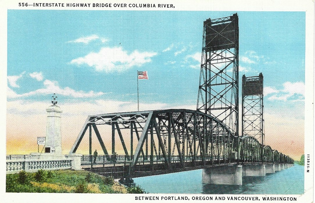
The Interstate bridge was the second highway bridge
built across the Columbia River. The first bridge over the
river was the Wenatchee bridge, built in 1908. The Interstate bridge was the biggest
of its type in the world at the time. Its completion was set for January 1, 1917.
President W. P. Connoway, of the Vancouver Commercial Club, said he believed Portland, which he called
Vancouver's suburb, should concede that more credit was due the Vancouver Commercial Club than any other agency
for the successful boosting of the bridge project.
"This day marks the purchase of the
wedding ring for Portland and Vancouver and the wedding will follow with the completion of the bridge."
said George L. Baker "Let us hope that Vancouver will prosper and grow until Portland is truly a suburb, for
Portland wants all the cities around it to grow out of their former bounds. Too much credit cannot be given those
who have worked for the bridge and it is a great pleasure to see it under way."
James P. Stapleton, of Vancouver,
who was introduced as a "father of the bridge," said the way the people on both sides of the river had supported
the project assured him that the people of today have the blood and courage
of the pioneers. He said the bridge was really started back in November of 1911, when the plan was
first launched, although
many setbacks had been experienced since. "The zeal and faithfulness of the leaders in the campaign for the
bridge have been a source of great gratification to me," he said.
"Years ago in sentiment and spirit,
we bridged this river," said Frank B. Riley, "and now we are to bridge it in fact, with lines of steel. It has been
said that the bridge would never be built, but I knew, when the valiant delegation from Vancouver marched
over to Portland and launched the project, that nothing but heaven itself could stop it"
"This was the first meeting connected with this bridge that had not been attended with worries." said Henry Crass,
ex-mayor of Vancouver, and was head of the Vancouver Commercial Club when it was doing much work for the bridge. He said the only other highway bridge
across the Columbia at Wenatchee, was built after a somewhat similar arduous campaign, and he
had also
worked for the completion of that bridge.
Work Continues
During the fall of 1915, work was progressing along. On the Washington side it was like a great rodeo.
Beams, crossbeams and trusses of steel were being assembled. Each was cast for its individual position.
Each piece was true to a fraction of an inch to the place it must take. There
were thousands of tons that appeared as confusion, yet they were like threads from
which were woven and that one by one the spans were built side by side on the shore,
which in their proper time would be floated to the piers on which they were permanently
laid to rest.
While on the shore the spans
took shape. Out in mid-channel where the piers were to be set, the dredger
dug deep through the sand and the silt. Piles that were trees 100 feet high on the
mountainsides, were driven down until they refused to go deeper. From the Oregon
side puffing tugs escorted a barge loaded with a box made with heavy timber that was built on the shore.
This too was forced down over the piles and into the box concrete was poured until this artificial stone
rose above the surface and was then finished smooth.
This is what the builders called a dumb-bell pier.
Here too the exactness of preliminary measurements, control and the scientific analysis that fixed faith that the bridge
would stand against
flood and storm and carry its traffic without sway or give. The Oregon
Slough was also spanned and the piers were almost complete. Across the low bottom land, a fill like a monster snake was laid across
the 2 mile stretch. This fill presented problems for the engineers as the base was not stable.
The project started at NE Bryant street,
where Union avenue, now called Martin Luther King Jr. Blvd. had ended. the
road was extended northerly to the city limits, a distance of about one half
mile where a short fill was made between Bryant street and the south end of the concrete
viaduct. At this point a big concrete abutment was erected. From there, the viaduct
extended
219 feet to the north, spanning the railroad tracks and a gulch in which the
tracks ran.
At the north end of the viaduct, the
fill starts again and runs to the Columbia Slough road, a distance of about 800 feet. At this point, the extension
met with the south end of the long approach to the Interstate bridge. To clear the way for work on the viaduct it was necessary to erect a temporary wooden viaduct the full length of the project to carry the cars of the Portland Railway, Light & Power Company
and to enable the removal of the old viaduct, which was nearly all taken out
by Fall,
and cars were being routed over the temporary tracks.
Under the weight of the fill, the ooze under a section of the approach
on Derby Street (now called N, Interstate avenue) had sunk. There was a bulge
that broke open creating a large muddy mess.
On the bank of the Columbia Slough, the stratum, resting on clay slid into the
water and the channel bed then rose up 10 feet toppling over a pier.
Until the bridge was completed, the fill was watched so any sinks could be filled. Much of the fill was sand. To keep the sides from eroding, grasses and shrubs were planted.
The fills required 1,500,000 cubic yards of material with an average of 42 feet in width,
and 20 to 25
feet in height.
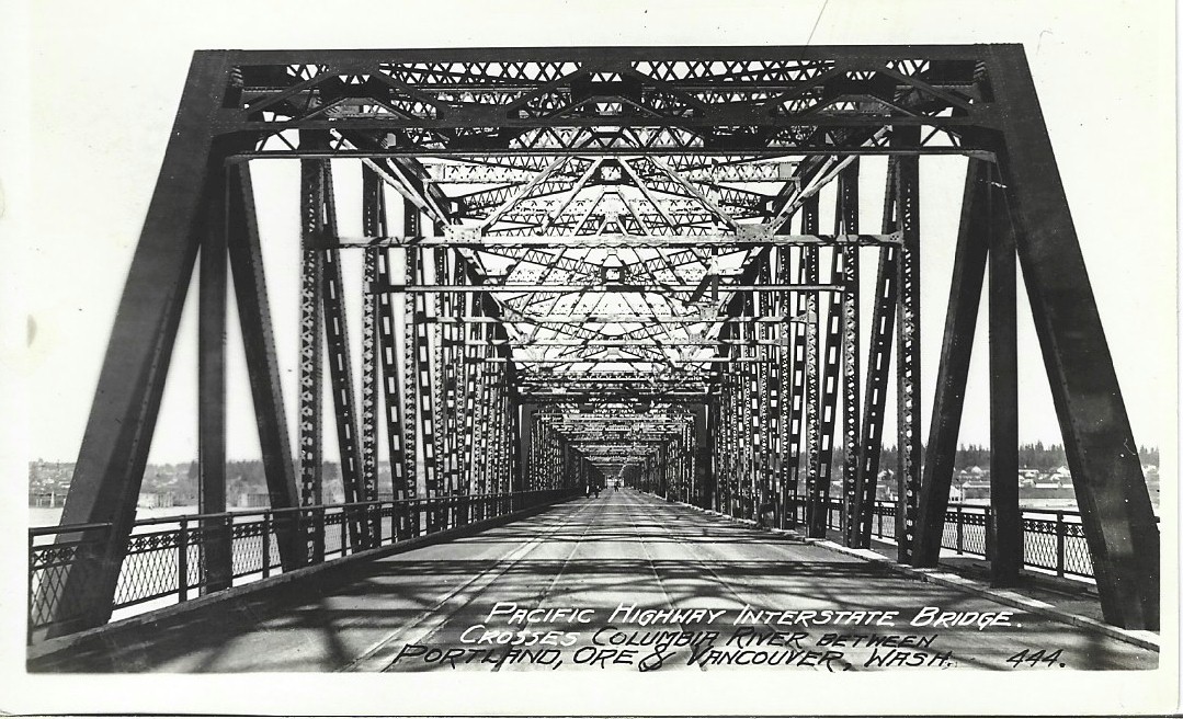
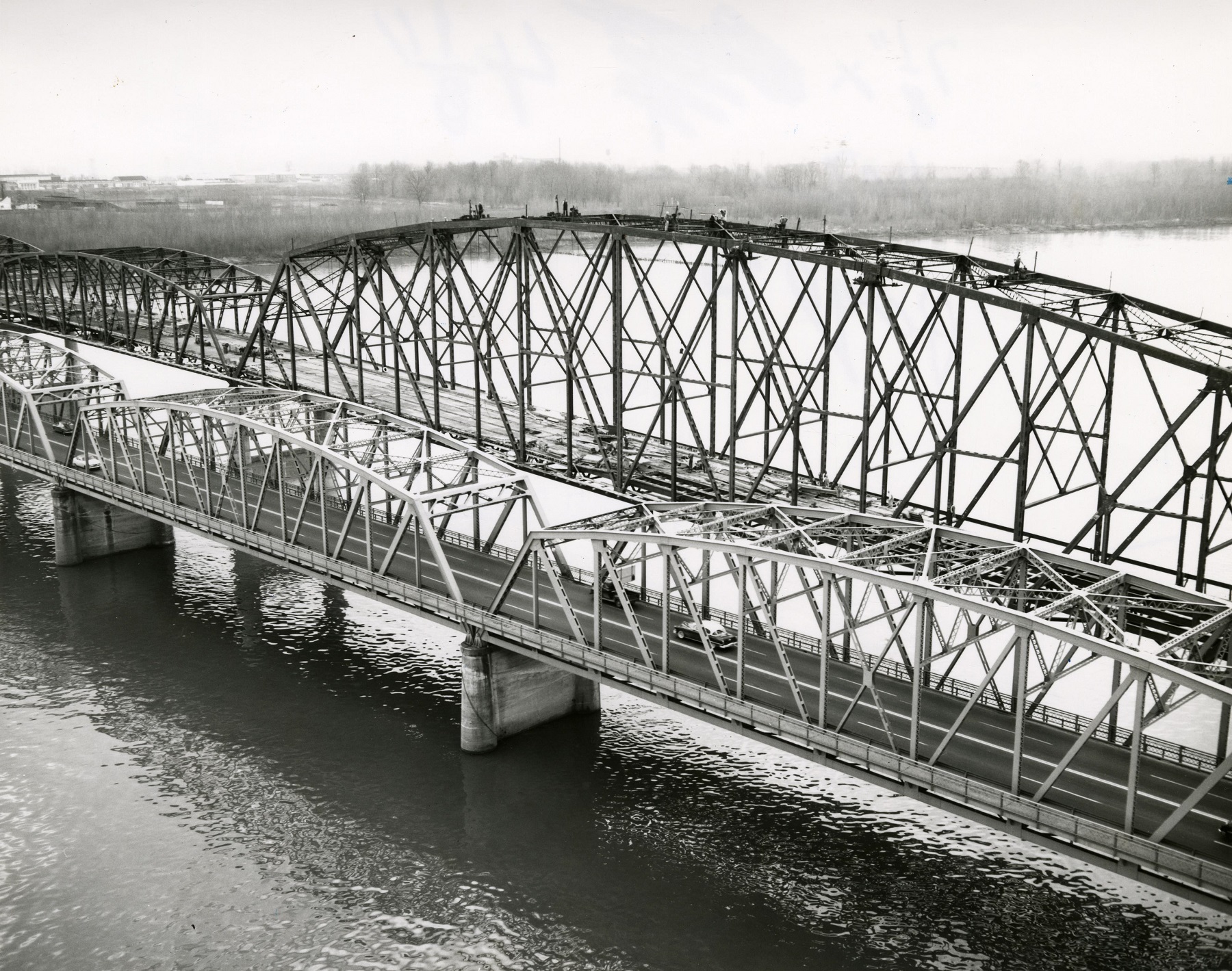
The Interstate bridge is 3.25 miles long or 17,000 feet, of which 5,000 feet was by piers and spans and 12,000 feet was over the fill.
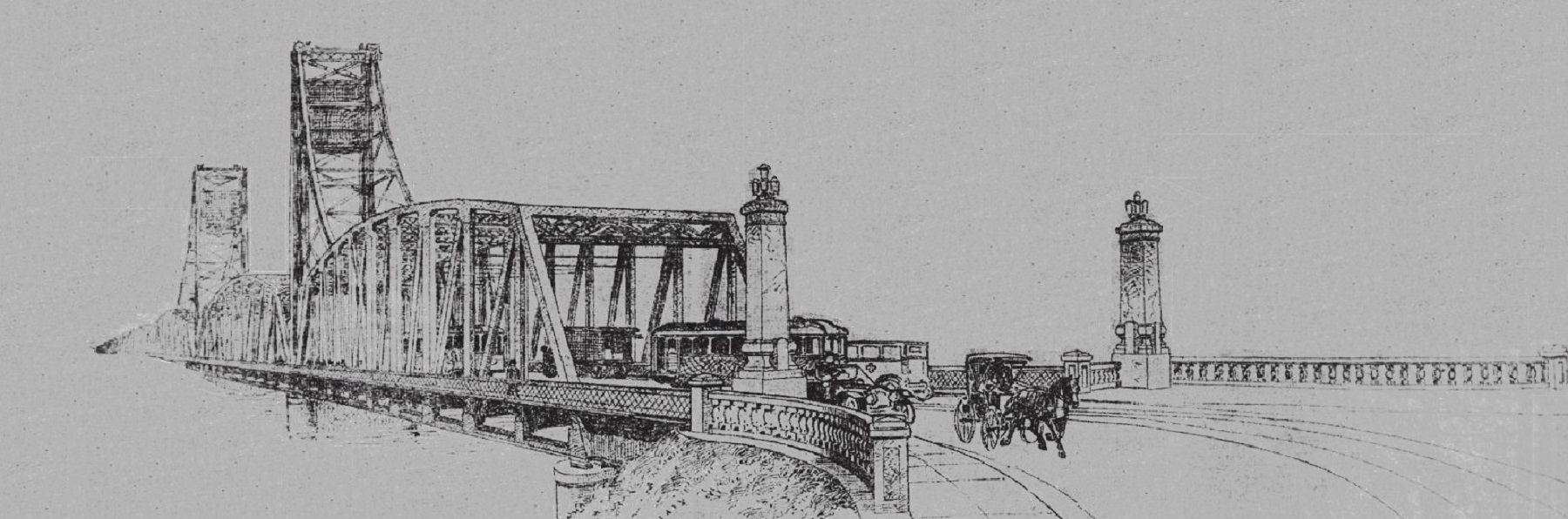
The weight of the steel bridge is 10,000 tons or 20,000,000 pounds and 370,000 bolts were used.
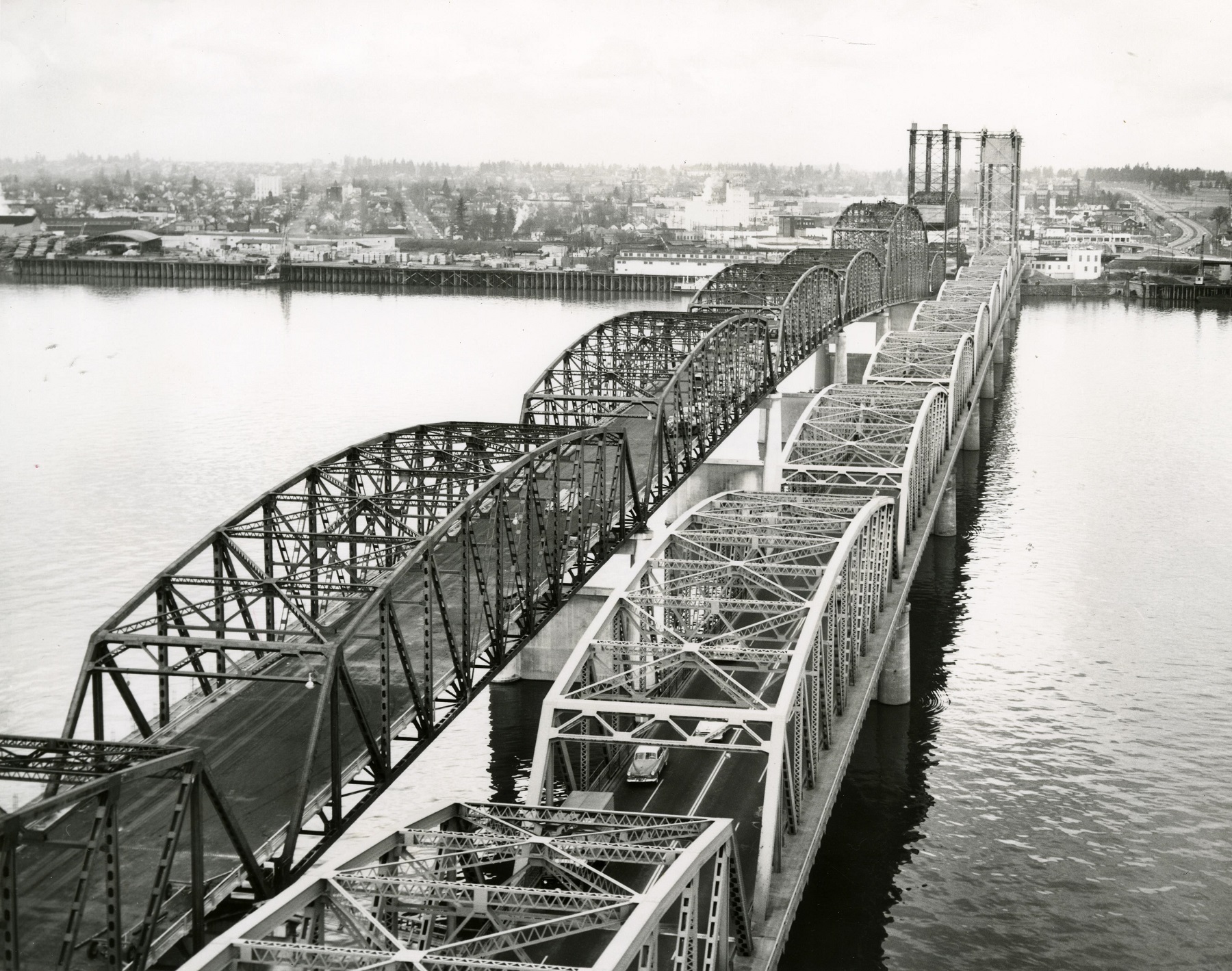
There are 13 full size spans, and 15 smaller ones. The lift span, near the Washington shore, is operated by steel towers. At rest, the lift span is 100 feet above low
water, and when raised it has a clearance of 191 feet.
The roadway on the bridge
is 38 feet wide between curbs and 41 feet between the trusses. The steel supports of the roadway are curved consistent with the curve or crown of the roadway.
The deck was originally paved with slabs of concrete.
On April 27, 1916, the piers had cured and the spans were beginning to be floated into place.
This was the day of a great engineering feat of floating the 650 ton draw span
which was executed at noon, when span No. 3 was placed on the bridge. Span No. 2, weighing
670 tons, was placed later last night, but it did not
drop into position until the next day, as one end had to be lowered 7 feet more
than the other on account of the incline.
The draw span was to be floated
on the 28th and was on a level with all of the other spans in the bridge except No. 2 and No. 1, the latter a short girder
span of 100 feet. The contractors, Porter Bros., McCreary & Willard, expected that a span
a day would be floated for the next 4 days. Then there would be only 4 more spans
that remained to be assembled.
Two large scows, one at each
end, was sunk under the spans. Cribbing was then built up from the scow to the bottom of the span.
The water was pumped from the scow, and this floated the span. Tugs towed the scows with the spans to a point between the piers.
Then the scows were sunk, gradually, and the steel span dropped into place.
The big fill at the foot of Washington street
was made from the shore to abutment "A," on the Washington side
and a concrete retaining wall was built. The paving of the spans would be
started as soon as possible.
On August 21, 1916, the Interstate Bridge Commission granted the Portland Railway, Light & Power
Company a franchise to run trolleys over the Interstate bridge. The company paid both Multnomah and Clark Counties one half of the net profits on the line from Columbia Blvd.
between Portland and Vancouver.
The street car company contract mandated that the company give a service of at least one car every 30 minutes from 6am to 11:30pm.
Tolls to be charged on the bridge, were 5 cents for crossing in vehicles not operating a regular
service, street car passengers 3.5 cents, other passengers 3.5 to 4 cents, according to the frequency of the service,
half ton trucks 10 cents, trucks over one ton 25 cents, trucks over two tons 50 cents, cars built to
carry more than eight passengers 25 cents, automobiles with capacity of less than eight passengers 15 cents.
On October 29, 1916, the Albina Commercial Club and the residents of Upper Albina were determined to fight to keep open and
maintain Vancouver avenue as a public highway to the Interstate bridge. They were ready to resist any
attempt to close any portion of the avenue. It was learned several months ago that the Multnomah commissioners had agreed to close up Vancouver
avenue on the completion of the bridge and use the Union avenue (Martin
Luther King Jr. Blvd.) approach.
Petitions were circulated demanding that the road be kept open and to repair the roadway from
Columbia Blvd. and to connect with the Union Avenue approach.
"I don't know how many have signed the petitions." said Mr. Calef, "but they
are coming in constantly. The heaviest property owners were backing this movement. To close up the Vancouver
avenue approach to the Interstate bridge, as promised by the present Commissioners, would be a
calamity, and would not be allowed by the residents."
"Vancouver avenue has been a public highway for more than half a century between Portland and Vancouver.
It is the geographical center of this district. Just why the Commissioners ever agreed to its being closed when
the Interstate bridge is finished seems incredible, but I understand that the
promise was made in exchange for rights-of-way for the Union avenue approach."
On December 23, 1916, the last span of the Columbia River Interstate Bridge was floated
into position, and as was expected, the time made was the best of all. At 1pm, the signal to cast
off was given, and the tugs Paloma and Rustler pulled the 500 ton steel
structure into the river, and the short trip upstream had begun. The greatest care and
accuracy had to be observed, as there was practically no leeway, the spans on either
side of the gap being filled.
But by 1:30pm, just 30 minutes after the first signal was given, the span was a part
of the Columbia River Interstate Bridge, and was resting in its place. Before the span was floated out, the draw was
lifted half way up and left there for the accommodation of river boats. The J. N.
Teal was perhaps the first boat to pass under the draw a few days prior. Though she could have gone
through the gap between the piers, the captain saw that the draw was up and immediately made a short turn
and passed under it.
When the last span was in place that day, Mr. Joseph Joseph, superintendent of
the work and who had charge of the floating of all the spans, without an accident, breathed a sigh of relief.
The most important part of the construction of the mighty Columbia River Interstate Bridge was completed, and
what remained to be done was trivial, compared with what had already been
accomplished.
Porter Bros., McCreary & Willard were the contractors who set up the spans and
floated them into place.
On February 10, 1917, the property owners and supporters of keeping open the
Vancouver avenue approach, won their battle
and the road would not be abandoned, as was contemplated, but would be repaired and maintained for at least
2 years. At the end of that time, traffic will have demonstrated
whether or not the approach should be made permanent. This was the decision of the Multnomah
County Commissioners at the close of a meeting attended by scores of property owners in the
vicinity of Vancouver avenue and members of the Albina Commercial Association.
After the 2 years was up, the approach had proved its worth and was allowed
to stay.
The 2,100 feet of the trestle approach and bridge over Columbia Slough was examined by an engineer of the road
department of Multnomah county, and an estimate was given for the cost of
the needed repair
work and the laying down of asphalt pavement. The work was done with money from the emergency fund
of the county, providing it did not cost more than $5,000. An estimate of Paul Struck, an engineer representing the property owners
who were petitioning for the continuance of the approach, said that the repair work would cost about
$3,000 and the asphalt pavement about $2,000 more.
Reversion of the property to the Louis Love estate in case the trestle was abandoned was provided
for in the
deed of gift of the land to the county, and the county commissioners were loath to relinquish the right of way,
which might become very valuable. Former demands of property owners called for an expensive fill and a new
viaduct across the slough, and were not looked, upon with favor by the
commissioners.
The requests were only for the repair of the present trestle and bridge until the usefulness of
a permanent approach could be demonstrated by traffic. Commissioners Holbrook and Muck
decided on the continuance. Commissioner Holman did not attend the meeting, but a communication from him was
submitted in which he favored means of holding to the right of way but discouraged
heavy expenditures on the approach. There are already
two other approaches to the bridge, the MLK Jr. Blvd. and the N. Interstate
avenue approaches both were provided for out of the bridge fund, which was exhausted.
The Ferry is Retired
When the Vancouver ferry completed her last run on February 14, the crews operating
her for many years left to seek other employment or retired. Captain Frank Stevens, a resident of
Vancouver for most of his life, had been in command of the Vancouver ferries
since 1878. He had traveled more than three times around the earth, but had not
taken a straight run of a mile during all of that time. In jest, he had said
he traveled across the Columbia River so many times in the same place that he
wore a rut in the water
several feet deep.
A. Munger, was chief engineer of the ferries for so long he almost forgot
the number of years, and he also took a much needed rest before going to work
for another company. Thousands of
residents of Vancouver and Portland had often seen the familiar face of Mr. Munger in the door of the engine room
on the ferry that was a time honored Vancouver institution, passed away for all time
on February 14, 1917.
No one was really sad for
the loss. The Columbia River Interstate bridge, which took its place, was a long stride
forward and no one wanted to go back to the slower and more inconvenient
method of crossing the river by ferry, though it has done its work valiantly and well.
But with the bridge traffic between Vancouver and Portland and between Oregon and Washington
would go on uninterrupted
day or night. Heavy ice running in the river no longer would isolate the city from Portland. It
would
be two years on March 7th, since the first sand was removed for the bridge.
Bert Brumagin, the night engineer, and who had been connected with the ferry for the past quarter of a century,
would also take a rest before going to other employment. Edward Angel, for several years
was the purser, would go on to be conductor of a St. Johns trolley. Matt Hogan,
a well known night watchman, would probably go with the ferry and be her watchman while
she was in the dry docks at Vancouver, being overhauled.
The
Bridge is Completed
On February 14, 1917, hands were stretched across the Columbia River and Oregon and Washington exchanged congratulations
over the completion of the Interstate bridge. The dedication and opening of
the structure to traffic was the motif
for a celebration in which the governors of both states, legislators, prominent officials and citizens
joined in.
The new bridge was opened officially to traffic at 12:30pm.
Two little girls pulled a bow of ribbon attached to a rope across the
mid-channel of the river. The rope crossed the line between Oregon and Washington.
The pull parted the rope, removing the last barrier between the two states and flags flew from the bridge
towers and a cannon from the Washington shore boomed out a loud salute and the structure was
then opened for
the use of everyone.
There was a long, parade of automobiles
that traveled from Portland to participate. The West Side contingent assembled on
6th street, in front of the Portland Hotel, facing Morrison street, before
11:30am, when the start was made. The East Side contingent of autos
formed on MLK Jr. Blvd. at Broadway and was ready to start at 11:45am when the West Side party, moving over the
Broadway bridge, joined them.
Sheriff Hurlburt was marshal of the parade.
Prior to the start, the Portland Police Band marched from the police station to the Portland Hotel and
played a number of airs to attract attention to the event. The band then
traveled by streetcar to the Interstate bridge, where they joined in the exercises.
The auto procession reached the bridge by 12:15pm and promptly at 12:30pm, the exercises were started. E. E.
Beard, president of the Washington State Press Association, was master of ceremonies on the bridge.
These events were staged on the draw span where the parties from both states met
as Mr. Beard introduced Samuel Hill, president of the Pacific Highway Association,
who spoke briefly of the significance of the occasion. Rufus C. Holman, chairman of the Interstate
Bridge Commission, then gave the signal for opening the bridge. Eleanor Holman, aged 10, daughter of
Rufus C. Holman, and Mary Helen Kiggins, 8 years old, daughter of John P.
Kiggins,
developer and Clark County Commissioner, pulled the bow that parted the ropes and opened the bridge.
At the same moment 4 huge flags, 2 on each of the towers, was unfurled, with 4 small
children holding the lanyards. These were the sons of Walter H. Evans, District
Attorney for Multnomah County, and A. A. Muck, County Commissioner, and the little daughters of Judge A. L.
Miller and M. E. Carson, of Vancouver. The Police Band and the Spokane, Portland & Seattle Railway Company
Band, of Vancouver, played "The Star Spangled Banner," and a mortar on the Vancouver shore blared forth
the good news to all the world that the Interstate bridge was open.
The Washington contingent then
moved across the bridge toward the Oregon shore and turned and drove abreast of the Oregon line of motorcars
to Vancouver, through the principal streets to the city park, where further exercises
were held. There, a program of short addresses was made, all limited to 5 minutes each. Those who
took part had some special relation to the construction of the bridge that made their place on the program
fitting.
The parade to the park was headed
by Captain A. R. Ehrnbeck of Vancouver Barracks, who had troops in line from that post, adding a military
note to the affair. M. E. Carson, chairman of the Commissioners of Clark County, presided
at the park. He first introduced Rufus C. Homan, who then became chairman and made a few
remarks before announcing Mrs. Fred Olson, of Portland, who sang "The Star Spangled Banner," accompanied
by the bands.
The history of the bridge was related in detail by men
who have been instrumental in bringing it to a realization. "We are celebrating the completion of a great bridge spanning the Columbia River at this historic place,"
said Mr. Holman. "Let us consider this bridge not only a necessary thing of great utility, but a monument commemorating
the unity of interests between the states of Oregon and Washington. This is an enterprise demonstrating
what we can do by co-operation."
"This is a notable event for all the United States, and not Oregon and
Washington alone," said Oregon Governor Withycombe; "This bridge connects up one of the greatest and most important
highways in the country. Forty years ago, when I crossed this river here in a boat, I wondered if the time
would come when it would be bridged. Let us take full advantage of our new benefit."
Governor Lister, of Washington, was to have been present, but could not attend. M. E. Carson, spoke in his behalf.
Mayor Albee spoke on behalf of Portland; "Let us hope, that this link that is to carry a great and growing commerce between
two great commonwealths will draw us closer together and that silver line, the Columbia River, will be a
tie that binds rather than one that separates us." Mayor Evans, of Vancouver, spoke on
behalf of Vancouver. "The people of two cities are mingled here celebrating an event which means the uniting of
the two commercially, industrially and socially," he said.
Edgar B. Piper, editor of The
Oregonian, was called to speak on behalf of the newspaper that had
worked for development of the Northwest for the past 63 years; "The old barrier between us
has been spanned," said Mr. Piper. "In crossing the river today the mind saw the Vancouver of old, the
historic Barracks, Indians going and coming, trappers carrying their skins on their backs to the
trading post, missionaries seeking to save us all,
and immigrants, some starving, but all helped by that "father" of all this country, John McLoughlin.
"Connect up these events with the present day scene and note
our marvelous progress," said Frank Branch Riley, who was introduced as one of the
fathers of the bridge. "As one of the fond parents of this bridge who cared
for it mostly when it was a squalling infant with fine lungs, but otherwise helpless and always
hungry. I attend these graduating exercises, so to speak, with mingled exultation and sadness."
"Our committee joins proudly in this celebration of an
achievement for which, for 4 years, we struggled incessantly. At the same time, like the evangelist
who finds himself embarrassingly out of a job, when the people are all converted, we today realize
that no longer are we needed to persuade suspicious legislators and unimaginative taxpayers that this bridge
shall immeasurably add to our wealth and importance, break down an ancient and formidable barrier
between the neighboring peoples and close the last gap in the Pacific Highway to meet the needs of increasing
industrial traffic and tourist travel over the great interstate trunk road."
"This bridge shall stand as an imposing vindication
of all the extravagant predictions of the early advocates. It is temporarily necessary to collect
tolls, but a publicly owned toll bridge is a relic of barbarism, and in violence to the Western spirit of
the times, and not for long shall the sovereign states of Oregon and Washington stand at either portal of this bridge and levy a petty tribute on every industrial truck, every investor, every
home seeker traveling over the longest international highway in the world."
One of the most interesting
addresses of the affair was delivered by E. E. Howard, representing the engineers
who constructed the bridge. "The actual construction has occupied a period of less than
2 years." he said. "The structure speaks for Itself. It is a product of careful planning.
You have to give credit to your officials who have had charge of this bridge. It is a
failing of the public not to give full credit to the work of your officials."
"It is usual and customary to make light of their work
and their efforts. For the present I will merely say that the bridge has been constructed within our estimates. Not only has the bridge originally contemplated been so constructed, but enough money was
saved to construct a second approach to Derby street. Moreover, portions of Clark County's saving have been
applied to the payment of bond interest, and with all this the Interstate Bridge
Commission undertakes the operation of the structure with considerable funds on hand."
"You may be interested to know that if
contracts were let today, the steel work would have cost $400,000 to $500,000 more than it has, or the whole
bridge from $600,000 to $800,000 more than it did cost and the structure is
fireproof."
Other speakers were David Morrison, of the Evening Telegram; Fred
Boalt, of the Daily News: Henry Crass, of Vancouver; N. B. Brooks, of
Goldendale;
and James P. Stapleton.
The Reclamation of the
Bottom Lands
During September of 1916, the approaches to
the new Interstate bridge, N. Interstate avenue and MLK Jr. Blvd., were
completed. The approaches consisted
of large hydraulic fills across the entire bottom. John A. Keating, president
of the Lumbermen's Trust company, conceived the idea of utilizing these fills, together with the railroad
fill a mile to the west and then by closing the two sides along the Columbia
and Oregon sloughs that would hold back the water so the land could be
reclaimed. This section was referred as Drainage District Unit No.1.
Accordingly, C. C. Colt, head of
the Union Meat company, and R. H. Brown, vice president and manager of the Peninsula Industrial company, authorized
L. B. Wickersham of Portland to undertake an engineering examination of the project.
It was shown that with suitable protecting dikes, inside drainage and automatic
gates, the lands could be effectively drained by gravity over the greater portion of the year, and by supplementing
this with a pumping plant to take care of rainfall and seepage during high
water. This work on unit no.1 was completed in the fall of 1917.
On February 3, 1918, the organization of District No. 2
comprising nearly 2,000 acres, extending from N. Interstate avenue up the river for
2 miles, had been perfected and construction was expected to begin at once so that
by the end of 1918, the entire 3,000 acres would be effectively
diked. In the upper district, gates were constructed through MLK Jr. Blvd. and
the N. Interstate avenue fills, permitting the drainage of both districts to be handled by
one pumping plant in District No. 1, and a new 20 inch centrifugal
pump directly connected to an electric motor added to this plant to supplement the same.
The gates likewise sectionalized the districts into
3 units as
a maximum measure of protection. The same plan of diking on No. 2 was followed
the same as District No. 1
and the east dike crosses the bottoms connecting the Columbia River and the Columbia Slough.
The upper end of District No. 2 is approximately 1.5 miles up the river from the
MLK Jr. approach
to the bridge. This work was completed at the end of 1918.
A Spring Trip over the New
Bridge
It was the beginning of Spring in 1919, when a party
from the Oregon Journal, comfortably seated in a Stutz touring car, set out for a ride from Portland to
Vancouver and back crossing over the Interstate bridge. Starting from The Journal building, the route went down
Broadway, across the Broadway bridge and on to Union avenue, which was followed north to the Interstate
bridge.
From the immense structure a wonderful view of
the majestic Columbia is had, which now presents a busy appearance along the Washington shore,
where extensive shipbuilding activities were being carried on. The City of Vancouver with its several
miles of paved streets was inviting to the motorist and the historic significance of
the city, which had its beginnings in early settlement of the Oregon country
through the location of a Hudson's Bay trading post has wide appeal.
Vancouver Barracks with its wealth
of military tradition woven in earlier days and the present day activities, ever
is of interest. The wide shaded driveways through the military reservation past
officers quarters, parade grounds,
barrack buildings and through the wooded portion lead ultimately to a paved
Clark County highway that stretches to the north. Vancouver necessarily need
not be the turning point on such a drive, as it was in this case, for the
North Shore highway
leading along the Columbia towards Camas and Washougal, or the paved Pacific
Highway that leads for several miles
to the north, afforded interesting glimpses of the orchards in which Clark
County abounds.
Returning across the Interstate
bridge, the route via the N. Interstate avenue approach that lead through Kenton. A turn to the
right on Lombard street towards St. Johns and to the left on Portsmouth,
brought one to N. Willamette boulevard,
an attractive drive along the cliffs on the east side of the Willamette
River, where an
admirable view of the river with the city and western hills in the background is to
be had. From this point a return to the business section by way of Killingsworth
and N. Mississippi avenues takes one by a different route.
Smugglers Captured on the
Interstate Bridge
On January 30, 1920, prohibition was in full swing keeping the
county sheriffs along the Pacific Highway plenty busy. That day, 3 men and a woman, alleged
Rum Runners, were captured on the Washington end of the Interstate bridge early
that
morning. This was after they had run the gauntlet past deputy sheriffs from
Kalama to Vancouver.
The alleged smugglers were said to have exchanged shots with Sheriff Hoggatt
at Kalama on the night of the 29th.
The Rum Runners tried to
mow down 2 deputy sheriffs who had ordered them to stop on the Salmon Creek bridge
north of Vancouver, and probably would have made their escape into Oregon if the authorities
had not closed the iron gates of the Interstate bridge in their faces.
The prisoners were Mr. and Mrs. Oscar Lund, R. W. Heddesly and R. E.
Lloyd, They obtained their liberty the day they were caught with each paying
the $150 bail.
Lund was said to have paid fines in both
Federal and Oregon state courts recently for bringing 100 gallons of wine here from California.
According to information from federal officers, the whisky seized was from Vancouver, B. C,
and was en-route to Portland. Almost a dozen cases filled with fine old Scotch were captured, and a similar quantity was believed to be hidden somewhere along
the Pacific Highway.
Sheriff Hoggatt at Kalama, obtained the first information
concerning the contraband booze. He tried to stop
the motorists and fired several shots at them when they blew by him at full speed. After a vain chase in his own automobile down the highway, he telephoned
ahead to
Sheriff Johnson at Vancouver. Sheriff Johnson then quickly ordered 2 deputies to guard the Salmon Creek bridge, on the
Seattle road.
He placed 2 more deputies on the Washington end of the Interstate bridge, and started at full speed to reinforce the detachment at Salmon Creek.
Meanwhile the 2 deputies on the Salmon Creek bridge saw the automobile approaching at high speed about 3am
Saturday morning the 30th. Flashlights in hand, the officers stepped out onto the bridge and
signaled the them to stop. Instead of stopping, the driver "stepped on
it," forcing the deputies to jump out of the way and onto the railing along the
sides of the bridge to escape from being run down.
As soon as the car passed
by them, the
deputies leaped down from their perches, drew their revolvers and opened fire on the fleeing automobile,
but the car went on at full speed. One bullet evidently struck a tire however, and about
3 miles further, the smugglers were forced to stop by the blowout. The cases
of booze was then hidden in a nearby barn, where a farmer found it the next
day and turned it over to Sheriff Johnson.
After hiding the liquor, the fugitives started on down the Pacific Highway for Vancouver.
They whizzed by Sheriff Johnson, who was headed
the other way to Salmon Creek with the throttle of his machine wide open. The sheriff
had supposed that the runners were stopped on the bridge, but quickly turned around, and gave chase when
the runners blew past him at full speed. The sheriff was unable to overtake them,
however as they sped through
the streets of Vancouver toward the approach to the bridge, and sped over the span to the state
line.
The deputies saw them coming,
and
ordered the bridge tender to close the iron gates. The barrier clanged shut directly in front of the smugglers,
who were then forced to use the emergency brakes to avoid crashing into the
gate. William Bryon, special agent of the
department of justice, said that he was considering prosecution of the prisoners for attempting to smuggle,
liquor into Oregon. He had not completed the investigation of the case, however, and
did not know what measures he would be able to take since they never made it
over the line into Oregon.
The Pacific Highway is
Completed
During March of 1922, The Pacific Northwest was host
to French war hero General Joffre. The French marshal was invited to
dedicate the completion of the Pacific Highway. The General reached Victoria
B. C. on March 27th, and traveled to Portland on the 29th. At Portland,
the General was greeted by a
committee of women who carried floral greetings to the train and held a formal reception in the depot.
The committee then escorted the General to an automobile and then a parade formed to escort the visitors to the bridge.
There events were held dedicating the completion of the Pacific Highway. Portland school children had gathered along the route of the parade.
Afterwards the General traveled to Blaine to dedicate the Peace Portal.
Second Bridge is Needed
During the 1940's,
traffic had been on the increase and it became apparent that a second bridge
was now needed, though it would take another decade for it to come to
fruition. In 1957, construction began
on the second Interstate bridge. The second bridge was ready and opened for traffic on July 1, 1958.
Separated by only 30 feet, this new bridge was made to look like first one. The bridges
then became one-way, with the old 1917 bridge carrying northbound traffic and the new
bridge carrying the southbound traffic.
The Interstate bridge has had two periods of tolls. The original toll began in 1917 and was removed in 1929. Then,
after the construction of the
second bridge, tolls were once again put on the bridge. This second tolling lasted until November 1, 1966.
The 100 Year Anniversary
On February 14, 2017, for the 100 year anniversary
of the Interstate bridge, John F, Barber was commissioned
by the PDX bridge festival, with TenBridge Partners, the Red Lion on the River,
and the Oregon Historical Society, created a sound work to help celebrate the 100th anniversary
of the bridge. Remarks, by both speakers and radio announcers, were incorporated into a script.
Recordings were, when possible, collected from individuals holding the same positions or similar to the historic speakers, all reading from
the script. Local voice actors volunteered their time and effort. The cast included;
Eric Newsome as Announcer; Toni Lima as Cameron Cameron; reporter Eli Campbell as Carrie
Phillips; reporter Ira Kourtum as Mr. Joseph Joseph; construction superintendent;
Martin John Gallagher as Rufus Holman, Multnomah County Commissioner; Chris Porter as James Withycombe, Oregon Governor;
Todd Tolces as H. Russell Albee, as Portland Mayor; Mayor Timothy Levitt as Milton
Evans; Vancouver Mayor, Curt Hanson as Edgar B. Piper; editor of The Oregonian;
Sam A. Mowry as Frank Branch Riley; organizing committee chair and producer,
John F. Barber as Sam Hill, President of the Pacific Highway Association.
Listen to the radio show at
the link below.
A
Mighty Span - the 100 Year Anniversary
Source; Washington West of the
Cascades, by Herbert Hunt and Floyd Kaylor, printed in 1917.