![]()
The Historic Pacific Highway
in Washington
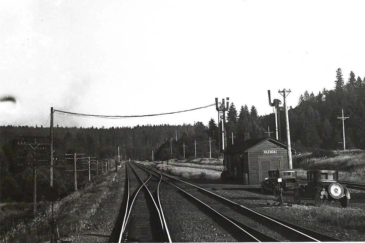
Olequa
![]()
The Historic Pacific Highway
in Washington
Olequa
History of Olequa
By Curt Cunningham
Olequa Creek and its First Inhabitants
Olequa is the name of a creek that flows into the Cowlitz river about 6 miles southwest of Toledo. Olequa is a variation of the name "Aloquois." On the 1858 township map of Section 10 north, 2 west, created by Surveyor General James Tilton, Olequa creek is spelled "Aloquois." Some have called it Iroquois creek, which I believe is a misspelling of the name "Aloquois." Olequa sounds very similar to Aloquois, and it was common in those days to have multiple variations of Indian words written in English.
There used to be a large Cowlitz village at the mouth of Olequa creek called "Kamtsi," which was a busy place during the salmon spawning season. Kamtsi translates to; "where the salmon run to." Since then many people from the Cowlitz tribe continued to live in and around Olequa. In 1910, there were about 100 members of the Cowlitz tribe living in the vicinity. The largest Cowlitz settlements in 1910 were at; Olequa, Toledo and Randle.
The Military Road
The first emigrant from the east to arrive at Olequa was in 1851, when William H. Pumphrey, who settled at the mouth of the creek. By 1860, Pumphrey had built a hotel with a saloon to serve the local residents and the traffic going between Portland and Puget Sound. His hotel was the second stop on the way north. When the river was low, Pumphrey's was the head of navigation for the traffic on the river. The place then became known as Pumphrey's Landing.
In the late 1860's the Oregon Steamboat & Navigation Co. ran steamers to Pumphrey's Landing to connect with the stages traveling the Military Road to Puget Sound. From 1871 to 1875, the steamer Wenat ran a passenger service between Monticello and Pumphrey's Landing. The opposition boat Vancouver would make the trip at various times during those years.
The small village that sprang up at Pumphrey's Landing became known as Olequa in the spring of 1871. On May 20, 1871 a traveler wrote about their stagecoach ride from Olympia to Portland; "From Olympia to Skookum Chuck (Centralia) is very fair generally, not less than six miles an hour being made by the stage teams with full loads of passengers. Between there and Pumphrey's, it is horrible beyond description, occupying full six hours to make the seventeen miles to McDonald's (Napavine) where the passengers, remain overnight, and five hours to make the next fourteen miles to Pumphrey's on the following day."
During the Winter of 1872, the road between Pumphrey's and Olympia had become so so bad that the mud wagons could not get through and they were taken off the run until the road improved. Anyone going between Portland and Olympia had to ride a horse. The mail was also carried on horseback.
By the 1880's, the new Westside Highway was completed along the west side of the Cowlitz river replacing the Military Road. Sections of the old road over the mountains continued to be used by the locals until about 1915, when it became impassible for autos and wagons because of the downed trees and overgrowth. Today small sections of the old road between the Jackson Inn and Pumphrey's hotel, is used by local residents and the power line across Pumphrey's Mountain follows close to the old path.
The Northern Pacific
On December 25, 1871 stage owner George Coggan said that there were 20 buildings being built and a thriving town called Olequa was springing up at Pumphrey's Landing. Pumphrey's would become the terminus of the railroad for the next 9 months. The Northern Pacific railroad had just reached a point about 4 miles from Pumphrey's and the crews built a temporary steamer landing. The trains would run to the end of the line and the passengers would board a steamer for a 4 mile trip up the river to Pumphrey's landing. Stage coaches would be waiting at the hotel to take the passengers for a ride over the Military Road to Olympia.
During the summer of 1872 Olequa was getting to be quite a commercial place. There was now a sawmill and several stores. The railroad bridge was about to begin construction, they were just waiting for the water level of the river to drop a bit before they put up the bridge. Rumors began to spread that the construction of the railroad would make Bill Pumphrey one of the richest men of the Territory.
On July 20, 1872, the rails were almost to the river and train passengers now stayed over night at Kalama going both ways. Travelers going between Portland and Olympia could now ride in a comfortable passenger car, for twenty-five miles, from Kalama or Pumphrey's. This was a great luxury to those who have had to take the trip over the rugged mountains through mud and rain. The railroad reached the Cowlitz river opposite the mouth of Olequa creek in August of 1872. The bridge over the Cowlitz river at Olequa was completed during September of 1872 and the line reached Tenino that November.
The railroad helped bring more people into the area, and the post office at Pumphrey's was re-established that year. (On October 30, 1867, the first post office was established and was named Pumphrey's Landing. The post office remained open for only a year and closed on July 16, 1868. This was most likely because there was not enough residents to sustain it.) On December 18, 1875, the Pumphrey's Landing post office was renamed Olequa with Samuel D. Laughlin the postmaster.
On May 4, 1882, a traveler wrote about their trip from Tacoma to Kalama; "The Pumphrey farm, at Olequa, marks the descent into the Cowlitz, and is a place of which its owner may well be proud. It is located on high ground, and far above overflows, yet the soil is of the best, and the cultivation quite thorough. All through the valley magnificent places can be seen, and in some parts the settlements are close enough to give the appearance of country towns. The Cowlitz farmer has much to make him contented and happy, and his measure would be full to overflowing were it not for the overflows of the river."
"There is an appearance of thrift and plenty from one end of the road to the other. The towns at the stations have all grown up since the advent of the railroad, and their newness is quite apparent. They have already passed the older towns of the country adjacent. Evidence of an increase in population can be seen on every hand. New houses are building, new homes making, and new farms being carved out of the forest. The railroad itself is a fine piece of work, being in good condition, riding easily, and the trains making fast time over it. Good as the country is through which the road passes, it is not, in an agricultural sense, as good as is the country generally adjacent. The railroad was built with no reference to that object, but on the contrary was made to avoid the lower, more indirect, lengthy and costly route that would have been necessary in running through the heart of the agricultural region."
A Rough Place
Olequa was a rough place in the late 1800's where fights, murders and robberies were commonplace. Alcohol played a big part in many unfortunate events that resulted in death. One drunken logger passed out on the mainline and was run over by a train. Another drunken man was shot after he yelled at and scared away a farmers dog. In 1883 a poker game at the logging camp ended up with all the drunken players killing each other after they were accused of cheating. One poor resident of Olequa had her clothes catch fire while doing chores and the burns ended up taking her life.
On January 4, 1880 William Pumphrey and Jack Vincent got into a fight in the Olequa saloon. The yelling quickly turned into a fist fight and during the row Vincent pulled out a knife and stabbed Pumphrey in the abdomen and in other places on his body inflicting serious injury. Dr. Whitehouse was called to attend Pumphrey's wounds.
On June 30, 1909 Edward Bertrand proprietor of the Olequa hotel was shot and wounded by Alexander Dean, a logger from Vader. Dean was put under arrest pending the outcome of Bertrand's injury. Dean accused Bertrand of being drunk and provoked a fight which led to the shooting. Bertrand remembered nothing of the incident.
On the night of June 21, 1912 Roy McNier was fatally shot by a watchman while attempting to burglarize George Bertrand's store at Olequa. The store had been burglarized 4 times previously and as a precaution Bertrand hired 2 security guards to watch his store. The burglary was attempted when a freight train was passing, in order that the noise of the passing train would hide the noise of the break in. When McNier broke through the door he was seized by by one of the watchmen, but after a short struggle was able to break free. He was shot in the left side as he attempted to make an escape. He was put on the train for Portland but died on the way. Before he died, he confessed to the sheriff that he was the one who burglarized Bertrand previously. He said he was from Montour, Iowa.
On September 10, 1913, someone sold liquor to the boys at a public dance at Olequa. After a few hours of dancing and socializing a fight erupted that turned into a free-for-all that ended the dance.
The Union Pacific
In the spring of 1890, the Portland Railway Extension Company, was established. This company was owned by the Union Pacific. They planned to build 3,000 miles of new road in the Northwest. The company was going to build a line from Vancouver to Seattle. The right-of-way was to run up the east side of the Columbia and then cross over the Cowlitz river at Longview and run north to Olequa, then to Evaline where it would have crossed the Northern Pacific tracks and then continue down the hill west of Napavine to Chehalis. William Pumphrey seeing a financial opportunity, platted out a town next to the right-of-way and called it West Olequa. This town was to be located at today's intersection of the Westside Highway and the Olequa Heights Road. The town, like the railroad, would never be built.
This was because of the Panic of 1893 which caused the Union Pacific to go bankrupt. In 1909 the Union Pacific and Northern Pacific signed a 100 year agreement to share the tracks between Vancouver and Seattle. The agreement was extended in 2009 and Union Pacific trains continue bring in corn and soybeans to Pier 86 in Seattle over the now Burlington Northern track.
Olequa Hops
In the 1880's and 1890's hop farming was one of the main industries in Olequa. Many Cowlitz people were hired as hop pickers. E. R. Patterson who was known as the "Hop King" had a large hop farm at Olequa and was considered to be the largest individual hop grower in Washington.
On October 20, 1893, Patterson reported an extra large yield of a fine quality. He had employed 800 hop pickers, though he said they weren't making very good money as the work wasn't steady due to the lack of drying facilities. Patterson paid his workers $1 per box, and furnished free lodgings and potatoes as he grew 40 acres of spuds and invited his pickers to take what they wanted during the picking season. There were 3 general stores, a meat market, barber shop and a photograph gallery that were temporarily located near the hop fields that made the place look like a booming little town.
On December 24, 1897 the Chehalis Bee reported that A. U. Alexander, agent for Balfour, Guthrie & Co., purchased from Patterson, 801 bales of hops, for 12 cents a pound. This firm also purchased 101 bales from H. J. Betty of Toledo, at 12 cents a pound. The Patterson and Betty crops and some other lots that were bought in Chehalis were shipped direct to London by Balfour, Guthrie & Co. They made a special train consisting of 16 to 17 cars. The total value of the hops was about $35,000. In today's dollars the purchase would amount to $1,126,131.33. The train departed Chehalis with a banner, "Chehalis hops, shipped to London by Balfour, Guthrie & Co." The hops were graded on the London market as "Choice Chehalis."
In 1905 Patterson had 75 acres of hops and controlled George Bertrand's 20 acres. They were short of pickers that season and were estimating a loss of about 20% due the the shortage of help. The yards were equipped with modern improvements for crop handling. The yield that year was a little large than last year and was of much better quality.
The 1906 Flood
On November 18, 1906, the Cowlitz river flooded and the torrent washed away most of the Olequa bridge. The train coming from Portland was stranded between Castle Rock and Olequa and the passengers had to be rescued. All the trains coming from Tacoma had to stop at Olequa and the passengers were then transferred onto steamers that took them to Castle Rock where they boarded another train for the remainder of the trip to Portland and vice versa. There were also many travelers who took the train from Tacoma to South Bend, where they boarded a steamer that took them to Astoria. From there, they hopped on another train to Portland.
The Road from Portland to Seattle
Before the Pacific Highway was built, travelers would take the best route available on their way between Portland and Puget Sound. They had to rely on the newspapers or from anyone along the route who would be willing to give their best guess. The best route north from Portland in the early 1900's crossed the river at Kelso to the Westside Highway north to Olequa. Back then the Westside highway was known as the "Logging Road Highway." At Olequa, the traveler would have 3 routes to chose from. 1) was to cross the river at Olequa and follow the road on the south side of the river to Toledo. 2) was to take the road on the north side of the river to Toledo. 3) was to travel from Olequa to Vader and then northward to Winlock, Napavine and Chehalis.
In 1907, C. J. Franklin who was a descendant of Benjamin, along with his wife, decided to take a trip in their new Oldsmobile "43" from Portland to Seattle to visit friends. From Portland, the two explorers took the ferry over to Vancouver and from there, drove to Kelso where they crossed the Allen Street bridge and took the Westside Highway north to Winlock. In 1907, the road was much the same route as the 1915 tourist would follow. The worst going of their entire trip was between Kelso and Winlock.
 It was along this patch of road, that held up one of the
cars that came through on an around-the-world trip that same year. The French car was
stranded in the mud for 3 days while enough horses could be assembled to pull it out. The driver said that
it was
the worst stretch of highway he had met on his entire trip around the world,
except for the passes in the Alps.
It was along this patch of road, that held up one of the
cars that came through on an around-the-world trip that same year. The French car was
stranded in the mud for 3 days while enough horses could be assembled to pull it out. The driver said that
it was
the worst stretch of highway he had met on his entire trip around the world,
except for the passes in the Alps.
Franklin then said, "So you can imagine what an inexperienced driver like myself was up against. A large share of the roads in those clays were of the corduroy variety with lots of the corduroy out of it. But there were 2 miles of swamp between Kelso and Winlock that wouldn't even hold logs. Twelve-inch planks had been slapped down on either side of the road to invite traction."
"I knew mighty well that if our wheels left the planks that we would be in the swamp up to our necks and that the little car would pass on to the happy hunting ground. So I directed my wife to drive the car while I walked along to guide the wheels and prevent a dire catastrophe. Finally we did reach Winlock after dark. There were no good hotel accommodations at Winlock, so we put up at a hospital, and pushed the heroic little Olds into a stable, there being no garages in those days. There happened to be no patients at the hospital so we cut loose and had a glorious time, even though we should have been taking the rest cure after earning the right to be waited on like invalids."
It took the Franklin's 3 days to reach Seattle. Today the trip on the freeway would take about 4 hours in good traffic.
During the summer of 1909, the Portland Automobile Club had written a letter to the Alaska Yukon & Pacific Expo asking that they set aside a day in August for the Automobile Club. They planned to have a caravan of over 200 autos travel from Portland to Seattle to attend the fair. The club president E. Henry Wemme advised travelers to cross the bridge at Kelso and take the Westside Highway to Toledo. The president said not to take the ferry at Olequa.
The Pacific Highway Crossing of the Cowlitz River - Olequa or Toledo?
In 1910, the Northern Pacific was in the process of realigning the mainline between Vancouver and Tacoma for the laying of double tracks. The bridge at Olequa was to be abandoned along with much of the right-of-way between Tenino and Vancouver. The railroad let the state know that the abandoned right-of-way along with the Olequa bridge would be available for a north-south state trunk road.
When the Pacific Highway was created in 1913, the state only designated the main towns that the highway was to pass through. The route between these towns would be determined later. From Chehalis southward, there were 2 competing routes that the state had to chose from. They were; the Chehalis-Olequa route or the Chehalis-Toledo route.
On May 30, 1913, the state highway board inspected the proposed "west-side" short cut of the Pacific Highway, which would lead through the towns of Napavine, Eveline, Winlock, Vader and Olequa. At Olequa the inspectors met a committee of businessmen from those towns and were escorted back to Chehalis for a meeting on the proposed route. The west-side interests knew it would help the towns and their businesses prosper if they could secure the highway. Likewise it would spell disaster to business if the highway bypassed them.
On July 30, 1913, Governor Lister and Commissioners E. E. Teachnor and T. J. Long along with County Engineer Ward, took a trip over the proposed Chehalis-Olequa route of the Pacific Highway. This proposed route followed closely to the railroad tracks running through Napavine, Eveline, Winlock, Vader and Olequa. They left Olequa shortly after noon and arrived in Chehalis at about 4:30pm. Short stops were made at Vader, Winlock and Napavine, where the governor made short addresses on the importance of good roads. The party had lunch in Winlock and afterwards, they returned to Chehalis to view the new Lincoln creek bridge. Later that evening, they had dinner at Centralia and afterwards the Governor was taken back to Olympia.
On August 22, 1913, a rumor was going around that Winlock was to get the highway instead of Toledo. It was stated on good authority that the Cowlitz river was to be crossed at Olequa instead of Toledo. Another rumor floating around was that the route along the Cowlitz river would be abandoned and that the highway would go southward from Chehalis to the Cowlitz prairie store, and then over Pike's hill to Winlock and then south to Olequa.
On August 26, 1913, state engineers were making their final surveys of the proposed route of the Pacific Highway between Chehalis and Castle Rock. The report now showed 3 possible routes available. 1) the south side of the Cowlitz river from Toledo, leading to the Cowlitz bend, 2) the route down the north side of the Cowlitz river from Toledo to Vader and crossing the Cowlitz at Olequa. This route, would use the abandoned piers of the old railroad bridge and part of the abandoned right-of-way, 3) the route down the north side of the Cowlitz from Toledo and crossing the river on Kline's ferry near the Ferrier place that was located about a half mile west of the freeway bridges. The state ended up choosing the first option of crossing at Toledo and then along the south bank of the Cowlitz river to the bend.
The Pacific Highway Detour through Napavine and Winlock
On April 17, 1915, work on the Pacific Highway was to commence and the state highway dept had arranged for a clear open route around the construction for the summer tourist season. This would require that alternate routes that were plainly marked to be used. These detours would make the route between Seattle and Portland 199.9 miles long. The highway dept proposed that a bulletin board system be established to spread information regarding the road conditions with the cooperation of garages and auto clubs.
At the beginning of May in 1915, paving work began at a point about 4 miles southeast of Chehalis and in the vicinity of Toledo. This made the regular route of the Pacific Highway to be blocked for most of that summer. The detour was described in the Oregonian on May 9, 1915;
"Leave Chehalis going southeast on Market street, and follow pavement to its present terminus about 4 miles from Chehalis. Turn to the west, go one mile, then due south three miles to Napavine and cross the railway tracks and then parallel the west side of the track for one mile, then cross back to the east side of the track for a little over one mile, and then cross back to west side, and follow the road on the west of tracks through Eveline and on to Winlock."
"Cross the tracks to the east side in Winlock and follow, plank road along the track for one mile as it becomes a dirt road for two miles to the grade crossing to the west side of the track, then over a dirt road for 4 miles into Vader. Cross the track in Vader, then at forks of road east of town, take the south branch 2 miles to the Olequa ferry over the Cowlitz river. This ferry has bad approaches but can be used by automobiles exercising care. On the east side of the river there is but the one road to Castle Rock, which is well marked, but is narrow and has many bad grades with short and steep pitches. The surface of the road is fair. Most of the road, described from Chehalis to Castle Rock was a dry weather road and was the shortest route available between these points."
On May 17, 1915, the detour roads from Centralia to Winlock, by way of Napavine, were in good order. South of Winlock the highway, which leads over Pike's hill to Toledo, was impassable, and travelers were compelled to take the road through Vader.
On June 4, 1916, the Oregonian published an article by Chester Moores on his trip up the Pacific Highway from Portland. The following is a clip from that article when Chester arrived at Castle Rock;
"Before starting we were informed that the road via Winlock was shorter and better, (it was) but so many conflicting reports were received later that the writer, for one, is still in doubt as to which route is the one to be preferred. The Toledo way was followed quite generally by motorists last year and the garage chieftain at Castle Rock told us on our way home that we went the longer and poorer way by going through Winlock. The Toledo road offers several miles of pavement this side of Chehalis, which the Winlock route cannot boast of, but it is said that some rather uncertain corduroy lies along the Toledo route."
"There you have it. One native, clothed with apparent authority, will tell you one thing and the next fellow you meet will have a version that contradicts it exactly. Tis always so in matters of highway touring, the story usually switching with the viewpoint. Anyhow we took the road to the left at the bunch of signboards and found in less than a quarter of a mile that we were to have the pleasure and novelty of floating across the Cowlitz river on a community ferry that had been dubbed with the name Olequa in honor of a hamlet that lay just ahead. Between the hours of 6am and 7pm it costs nothing to ride on this ferry and the service is good. After hours a charge of 25 cents is made for every automobile."
"The man in charge of the ferry told us. Just as he will probably tell you, that the road ahead was shorter by 7 seven miles and "smoother" than the optional road by way of Toledo. Perhaps his job depends upon traffic, or more probably the fellow at Castle Rock was fibbing, (he was) but anyhow all of the road leading on to the Pacific Highway intersection just this side of Chehalis was not blissful, although it certainly averaged up into something pretty good. Some 3 miles beyond the ferry we passed through a little town that had a hotel with the sign "Little Falls" painted across the side. We asked one of the official town whittlers and he assured us the town also bore that name, but we learned later that this town is and always has been named Vader." (The post office was originally named Little Falls)
"All of which amounts to another warning that automobile tourists must not stake their lives on the information that they are apt to receive along any roadway, at Vader or elsewhere. Most of the road leading on through Winlock and Napavine was a fair proposition, although some of the corduroy along the short run from the Veness mill into Winlock was quite enough to tax a preacher's vow. We learned from no less an official than the town marshal, however, that this corduroy is to be yanked and replaced with pavement in keeping with the spirit of many Washington towns smaller than some Oregon towns that hardly dare pave their main streets."
"The Reo speedometer, which, as should have been explained earlier in this narrative, is not accurate because the gear ratio of the car was changed after the speed and distance recorder was put to work, marked the distance from the Olequa Ferry to Chehalis as 30 miles, which very nearly jibes with the Goodrich tour book. After taking the Winlock detour, or whatever it should be called, you will meet the Pacific Highway again on the pavement 2 miles this side of the heart of Chehalis."
On July 30 1916, the Oregonian described the Pacific Highway as going from Chehalis via Napavine, Winlock and the Olequa ferry. They said that the entire distance to a point 15 miles out of Vancouver, that the Pacific Highway might properly be called the "Terrific Highway" as it is very rough, narrow and terrifying in many places. Others called it a hog trail.
Pacific Highway Construction
On August 9, 1916, the Pacific Highway was detoured onto the ferry crossing at Olequa and then along the north side of the river to Toledo. About a mile north of Toledo the cars were detoured again onto the road over Pike's hill to Winlock. The detour continued through the town of Winlock and north to Napavine. From Napavine cars took the road to the right and continued northeast to the Pacific Highway a half mile south of Forest. From there it was north on the Pacific Highway into Chehalis.
The Olequa detour was used during the construction work north of Toledo. That fall, the river flooded and washed away a section of the Toledo bridge. The Olequa detour through Winlock would be needed until the bridge was repaired and reopened in August of 1919.
On December 29, 1918, the old wooden bridge across Olequa Creek collapsed under the weight of a heavy truck. During the spring of 1919, a new 100 foot bridge was constructed. This bridge was removed in the 1950's when the Westside Highway was improved and realigned.
During April of 1920, the Pacific Highway was impassible from Castle Rock to Toledo due to the deep mud. Some motorists tried to avoid the mud by turning west across the Cowlitz bridge at Castle Rock, then over the "Logging Road Highway" for some 5 miles to Olequa, Winlock and then into Chehalis. But this detour was as bad as the main highway if not worse, and it was washed out in places. The only way to get to Seattle from Portland that spring was by train. By May 15th, the road had dried out and cars were again routed over the bridge at Castle Rock and the Westside road to Olequa, and Winlock.
On April 25, 1920, the Oregonian ran an article about the condition of the highway. Motorists were detoured off the Pacific Highway at Castle Rock where they crossed the bridge and continued north on the "Logging Road Highway." After reaching Olequa, the traveler would take the ferry back over the river, and after a few miles cross back over the river a third time on the newly constructed bridge at Toledo.
The following is a report of the road conditions
the spring of 1920. "From Kelso to Castle Rock,
the road was rough and muddy, especially so at Ostrander where it was badly rutted
and full of chuckholes. At Ostrander, we were then told we could not get through with our car, as it did not
have enough road clearance. It was the first time I ever had cold feet. They advised me not to try it and
gave me all kinds of encouragement which made me wish I had an airship, but I finally decided to try it.
We pulled around the first car and a short way down the road met the other
unfortunates; a Dodge, a "Study" light six, Ford, Hupmobile, Buick and a Chevrolet. I don't know how we
got through."
"The good Lord or someone else must have guided us, for we passed by this lineup with the
running boards under mud, dropping the front wheels into chuck holes until the tips
of the front fenders plowed into the mud and pushed the mud through the radiator. I was afraid
I would have
an accident as the holes had chucks of wood, broken planks and limbs of
trees in them that someone had put there to help fill them up.
"We went along in low gear, got through and never stopped turning a wheel, neither did we have an accident. Arriving at Olequa, crossed the river and proceeded. But no cars are getting through now on their own power. They are lucky to get through behind a team of horses."
The Railroad Bridge that Became and Auto Bridge
On July 28, 1925, The Union Bridge Company was awarded a contract to construct a steel bridge across the Cowlitz river at Olequa. The stone piers which were formally used by the Northern Pacific, were purchased by Cowlitz county and the piers were cut down 7 feet and capped with concrete to carry the bridge structure. The Northern Pacific had offered to give the piers and right-of-way to the state back in 1910 for the Pacific Highway, but at the time, the Legislators from Puget Sound were afraid to lose business to Portland if a north-south trunk highway was built. When they finally decided to build the highway, they ended up choosing the Toledo route.
The bridge was 465 feet long and 18 feet wide, with an approach of 500 feet on the east side. The bridge replaced the cable ferry which could not operate during the high water and was not always available at night. This toll bridge was operated by the Olequa Bridge Company, which was owned by George Bertrand and Gene Huntington. Work on the bridge began in October of 1925 and was completed by November of that year.
The shipments of steel came to Vader on the railroad and was hauled down to Olequa. This was because the bridge across Olequa Creek could not handle the weight of the heavy trucks. Part of the Shepardson farm was condemned for the right-of-way on the east side and it was necessary to build a low fill across the field to bring the road above the high water mark. The toll bridge was built using private capital and was open at all hours of the day and night.
The Final Days of Olequa
The town of Olequa never really prospered and the post office had shut down in 1912, and on April 19, 1927, the plat of West Olequa was vacated. By the 1930's, the railroad station like the post office were now gone and all that was left was the George Bertrand store that he opened in 1900 at age 42 and operated it for 50 years when he shut its doors in 1950. He was the oldest active merchant in the State of Washington. George Bertrand would pass away at age 94 in 1952.
Travelers were now using the new Pacific Highway out of Toledo and traffic over the Olequa bridge began to fade. The old railroad bridge that became a highway bridge was removed sometime in the mid 1950's or 1960's.
Today, nothing remains of the little town of Olequa and the old Pumphrey's Landing except for the old concrete piers that once carried trains and later automobiles across the Cowlitz river.
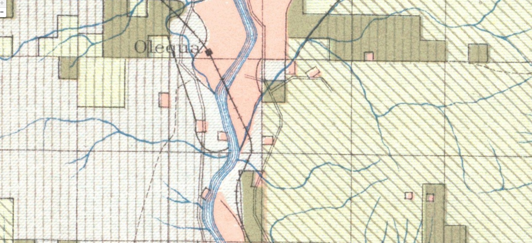
1910 map showing the original Northern Pacific right-of-way over the river at Olequa. 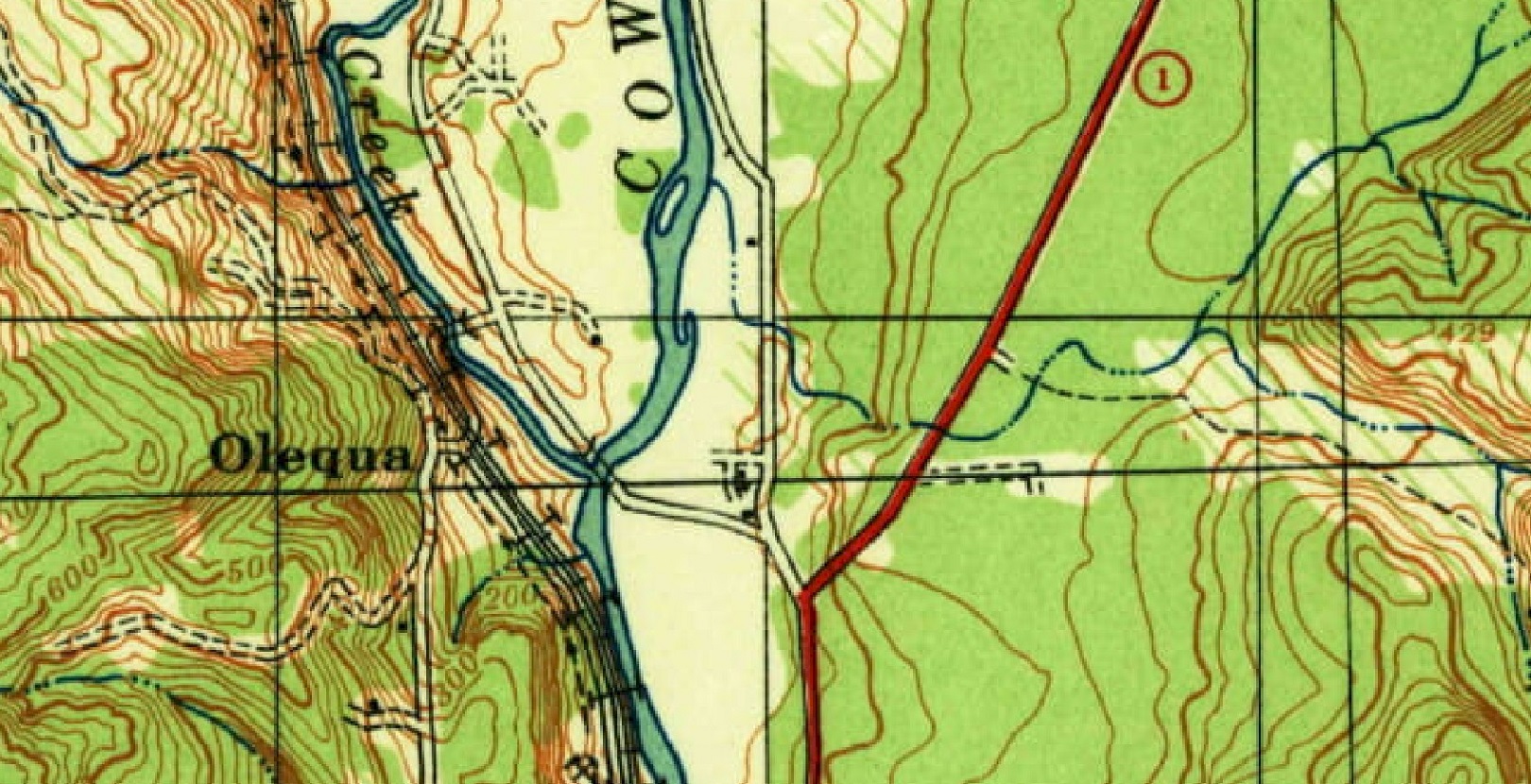
1941 map showing the new highway over the river at Olequa and the bridge over Olequa Creek. 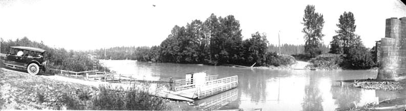
The Olequa Ferry in 1915 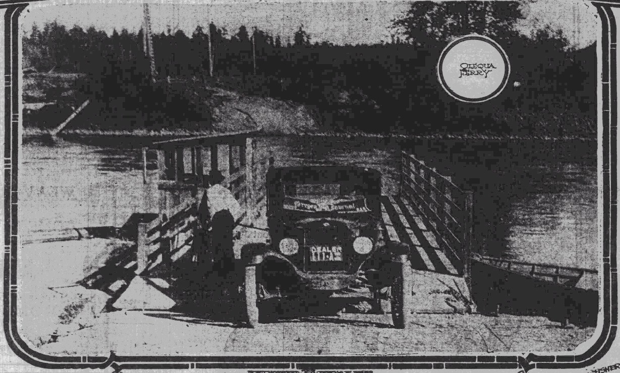
The Olequa Ferry in 1920 |
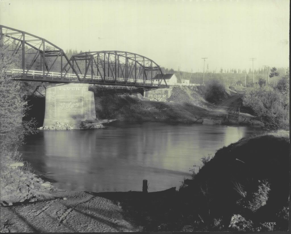
The Olequa Bridge in 1927 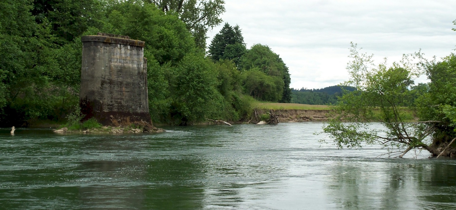
The old bridge pier, looking north upriver. 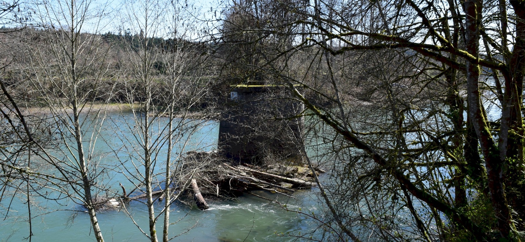
The old bridge pier from the west side. 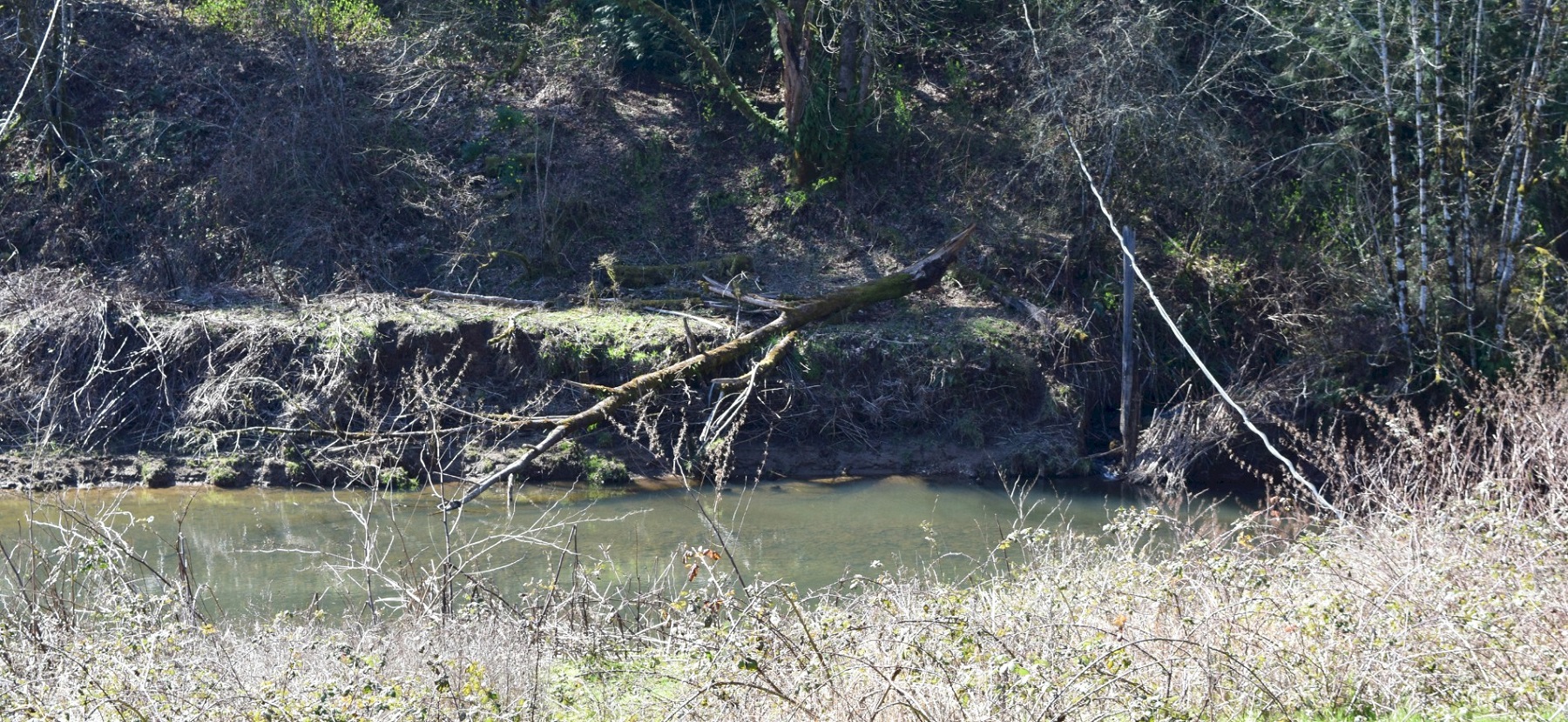
The old Olequa creek Crossing. The road turns to the left for the climb up the hill. |