![]()
The Historic Pacific Highway
in Washington
The Nisqually Bottom
![]()
The Historic Pacific Highway
in Washington
The Nisqually Bottom
History of Nisqually
By Curt Cunningham
The Nisqually River
The Nisqually river begins its journey on the southern slopes of Mt. Rainier and flows in a northwest direction and empties into Puget Sound just south of Anderson island at what is known as Nisqually Reach. The Nisqually Reach is a portion of Puget Sound south of the Tacoma Narrows, at the mouth of the Nisqually river and is classified as a bay by the United States Government. It was originally defined as "the portion of the Sound lying between Anderson Island and the mainland." The river is approximately 81 miles long and has a drainage area of 675 square miles. There are a number of creeks and rivers feeding it including the Paradise and Mashel rivers, and Mineral, Ohop, Pyramid and Kautz creeks.
In the spring of 1861, Walter De Lacy, William Packwood, James Longmire and Maj. George Blankenship embarked on an expedition to find a pass through the Cascade mountains south of Mt. Rainier. On the second day of their journey they reached the Bald Hills about 10 miles east of Longmire's home. According to an unknown English writer, in 1814 heavy fires raged around the Sound; and again in 1845, when the bald hills, between the Nisqually and Cowlitz rivers, were divested of high forests of timber.
After lunch they ascended the hills, which rise to about 1,500 feet above the prairies. Here they had a magnificent view of the whole country. De Lacy said that; "From the foot of the hills the Nisqually river could be traced with its two long tributaries the Ohop and Mashel, and a large lake, probably Kapowsin. To the west could be seen the Lackamas and Yelm prairies, and Nisqually plains, together with the coast range, and a part of the Sound. To the east were the Cascade mountains with numerous spurs, and Mt. Rainier towering gradually in the setting above them all."
The Nisqually river valley at its mouth is about 1.5 miles across and 3 miles deep encompassing roughly 3,000 acres. In 1875 George D. Shannon acquired the George Shazer claim, which was about 1,100 acres. He then began to dike the land converting the estuary into farmland. Alston Brown would complete the dike in the early 1900's. In 1974, the Billy Frank Jr. National Wildlife Refuge was established to protect the delta and its diversity of fish and wildlife habitats. In November of 2009 the dikes were breached and the estuary was restored reconnecting over 700 acres with the tides of Puget Sound. This was the largest estuary restoration project in the Pacific Northwest.
The Ice Age
During the Ice Age the advancing Puget Sound glacier began to cover or block the natural course of the rivers, which emptied into the Sound. For a time the glacial waters of the Puyallup, White and Carbon rivers from Mt. Rainier discharged through the Ohop valley and into the Nisqually river. This swelled the river to catastrophic proportions. The Nisqually river for a time also carried the escaping waters from the 1,000 foot thick Puget Sound glacier, much of which had gathered in a high-level lake in the Puyallup valley trough at Orting.
The escaping waters from the swollen Nisqually river drained through a low lying area between St, Clair and the Red Wind casino, and followed the course of Spurgeon creek where it then flowed across Bush prairie toward Black lake and followed the Black river to the Chehalis river while on its way to the sea. Eventually the ice for a time would consume much of what is now the Nisqually river, and it has been theorized that for a time the escaping waters of the Nisqually flowed into the Deschutes river at Clear lake in the Bald Hills.
Eatonville is built on the outwash gravels of this enormous glacier, which record escaping glacial water before the retreat of the ice had begun on the north and northwest sides of Mt. Rainier. The Nisqually river emerges from the foothills 5 miles south of Eatonville. At one point the Nisqually river near Eatonville was blocked and failed to follow its former course. Instead of flowing down the Deschutes channel, the Nisqually river cut right through a mountain of rock, which was plainly fractured. The river cut through 40 feet of outwash and 300 feet into andesite lava. This formed a canyon near La Grande that is as deep as it is wide. The La Grande dam built in 1945 flooded this narrow canyon and eliminated this natural wonder from ever being seen again.
A Natural Wonder
On January 23, 1879 the Vancouver Independent printed the following article; "the survey of the Northern Pacific railroad, under charge of Mr. D. Clark, the line runs through one of the canyons of the Nisqually river in which nature has formed a curiosity of more than ordinary interest which has never been brought into notice. Perhaps a brief description of it might be acceptable to your readers. The Nisqually river rises in the glaciers of Mt. Rainier and empties into the Sound near Steilacoom."
"Its total length is about a hundred miles, and the volume of water flowing through its channel is much greater than would be supposed by one unfamiliar with the swift mountain streams of this country. Improbable as it may seem, however, several of the men from Mr. Clark's party have accomplished the feat of bestriding the river at this point, which is forty miles from its mouth. The whole river runs through the channel of but a few feet in width, but of unknown depth, which it has cut in the solid rock, and at one point the walls or banks approach within three feet two inches of each other at a distance of about ten feet above the water at its present stage. Here the ambitious surveyors (emulating the familiar straddle-bug in evolution, but surpassing him in romantic sentiment) each, in turn bestrode the river, like the Colossus of Rhodes."
"The rocky walls do not overhang the water and form an arch over it, as may be supposed, but maintain their proximity below the surface of the water; the average width of the river bed is perhaps less than six feet for several yards on either side of this point, above and below. The canyon has many other features of interest, and presents scenery not unworthy of comparison with the famous canyons of Colorado, but this one point is so peculiar and curious that it is worthy of note, and should a railroad ever be built here will undoubtedly become a familiar and perhaps celebrated natural curiosity."
Lake Nisqually
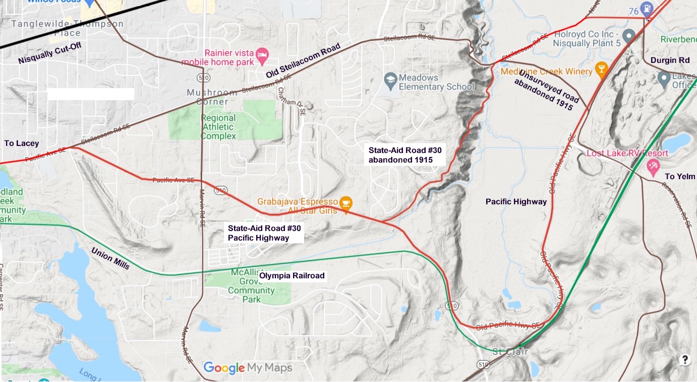
The retreat of the Puget Sound glacier permitted the formation of Lake Russell, which was a body of water that occupied the valleys of the Puget Sound area and discharged to the Chehalis river at Gate. The level of this lake through its existence was 160 feet above mean tide, which was about 130 feet above sea level of that time. At one point during the retreat of the glacier it had re-advanced a few miles. This forced the ponded water in the valleys to discharge at a higher outlet, which gave birth to Lake Nisqually.
Lake Nisqually was around 30 square miles, and if you draw a straight line from the Chambers' Bay golf course located north of Steilacoom in a southwest direction toward Lacey, the water of the Sound on the east side of your line would roughly be the size and location of the lake. Lake Nisqually discharged through St. Clair and across Chambers' prairie. When the ice retreated again, Lake Nisqually was destroyed and this allowed Lake Russell to re-form. The Pacific Highway at St, Clair roughly follows along the most southern tip of Lake Russell. East of St. Clair and just south of Sherlock is where the swollen Nisqually river emptied into the giant lake and formed a large gravel delta about a mile and a half wide.
The Sherlock Delta
As the ice withdrew from Thurston and Pierce counties, it left both the Deschutes and Nisqually rivers free to flow northward into Lake Russell. The Nisqually river at that time still carried the drainage from the northern and western slopes of Mt, Rainier through the Ohop channel, plus the water from the melting Puget Sound glacier. This large volume of water contributed to the creation of the Sherlock delta. The front of this ancient river delta rises abruptly 90 feet above the flood plain south of Sherlock. The altitude of its upper margin is 115 feet above sea level. Farther west the front is less abrupt, and the altitude is 120 feet.
After the Ice Age ended and Lake Russell disappeared, the water level lowered, and the Nisqually river began to cut through the old delta, creating the valley that now stretches southeast from Sherlock to Eatonville. Today the Lakeside Industries asphalt plant and gravel pit sits at the tip of this ancient delta. The gravel used in our local concrete and asphalt comes from the glacial till that has been gathered from pits located all around the Puget Sound region.
The Nisqually People
About 10,000 years ago the Nisqually people had migrated northwest from the Great Basin and arrived at the mouth of Skate creek on the Cowlitz river near Packwood. This was where they made their first home. Some time later they crossed over the mountains to the Nisqually river (possibly walking through the canyon that National Forest Road NF-52 travels on between the Cowlitz and Nisqually rivers.) and following it to the Sound. The Nisqually had 2 main villages in the Cascade foothills. One was at the mouth of the Mashel river near Eatonville and the other was downstream north of Clear lake in the Bald Hills. There were over a dozen other permanent and seasonal villages dotted along the Nisqually river all the way to the Sound. One of the largest villages was called Mit-suk-wei and was located near the Red Wind casino.
The name Nisqually comes from the Salish word "Squalli," which means prairie grass and "bsch" meaning people. The word "bsch," which is pronounced "bish" is also spelled and pronounced as "pish" or "mish" as in Snohomish, Duwamish, etc. The Nisqually people called themselves Squalliabsch, or "people of the river and prairies." Their territory encompassed most of the grassy prairies in south east Pierce county and some of the prairies in Thurston county, and it extended up the Nisqually river to its headwaters on Mount Rainier.
The Medicine Creek Treaty
In 1854, the Squaxin, Nisqually and Puyallup tribes were forced to sign the unfair Medicine Creek Treaty under a tree known as the "Treaty Tree," where the 3 day ceremony of the signing took place. This was the first important treaty with the Indians of the Sound, which was drafted by Territorial Governor Isaac Stevens. The Treaty tree was located on the north side of the freeway where it crosses McAllister creek. In 1922 the D. A. R. placed a bronze plaque on the tree to commemorate the signing, and also erected a historical marker on the Pacific Highway in Sherlock. The Treaty tree survived until 1979 after the construction of a fill on Interstate-5 near the tree led to its demise. In 1975 DOT employee Bill Melton gathered seeds from the old tree and planted them around the historical site, which today are over 40 feet high.
In the 1914 book Early History of Thurston County by George E. Blankenship says that; "The first Council in Thurston county was held on McAllister creek, a mile above its mouth, on the right bank. The tribes, 650 in number, assembled, and Governor Stevens gave the address in the Chinook Jargon as he refused to have it translated into the tribes language. The treaty was then read, section by section, and the tribes would discuss it. After which, the treaty was signed by Governor Isaac I. Stevens and the Chiefs, Delegates and Headmen on the part of the tribes. Provisions and presents were then delivered to the Chiefs, who divided them among their people."
On the old Pacific Highway near the Nisqually river, at the intersection with 7th Ave, and in front of the Texaco station, is the location of the historical marker commemorating the signing of this treaty. The marker was dedicated by the D. A. R. in 1922 and the installation of the monument was made by the Washington State Historical Society. In 1994 the marker was deemed to be in an unsafe spot and had it moved away from the roadside to its current location by the Thurston County Historical Commission.
The Nisqually River Crossings
There are 5 known crossings of the Nisqually river which were used by the Nisqually people between the "Upper crossing" at McKenna and the "Lower crossing" near Puget Sound. Most of these crossings could be forded in the dry season, but during the rainy season, fording the river could mean life or death. At the lower crossing a canoe or raft would be needed as it was too deep to ford at any time of the year.
There were 2 "middle" crossings of the river near the Red Wind casino. One of these was at the Nisqually village of Mit-suk-wei. This was the first crossing of the Nisqually river used by the Hudson's Bay employees who were traveling between the Cowlitz Landing and Fort Nisqually. In 1905 retired Hudson's Bay company clerk Edward Huggins, wrote the following about this crossing;
"The first trail that the HBC used from Nisqually to the Cowlitz was from the old Fort by the lane called Love Lane to the Squally River by Mit-suk-wei, a ford leading to the river from the Squally plain, down a very steep hill, by a small creek, Mit-suk-wei, a half mile through the bottom to the river which generally was crossed with the assistance of Indians and their canoes, although I’ve crossed it once or twice upon horseback, the horse swimming for a short, quite short distance when near the other side. The bottom of the Thurston county side of the river is quite short about 3/4ths of a mile to another steep bluff, then up to the prairie."
The other middle crossing was called "Tlalagweilmeen," and was about a mile upstream at the mouth of Muck creek. Nisqually tribal member Sam Pyello, was allotted land at the mouth of the creek and in the early 1900's, began to ferry travelers across the river in his canoe. His place then became known as Pyello's Landing. Both of these crossings had trails going up and down the steep cliffs on either side of the canyon making the crossing even more difficult. The trails on the hills can still be seen on the terrain view in Google maps.
About 5 miles further upstream was the "Stony Ford." It was located near where the railroad tracks cross the river northwest of Yelm. This trail connected the Yelm prairie to a prairie across the river called “Thull-hull-illahe.” Edward Huggins wrote about crossing the Stony Ford in 1850. The story goes that Huggins while on his way from the fort to the Cowlitz Landing accidentally took the wrong turn on the trail and came to this crossing.
The river was very high, he said, but decided to cross it anyway which was a mistake as he fell off his horse before reaching the other side and they both struggled to swim the rest of the way to reach the other side. After almost drowning, Huggins and his horse made it across. Luckily for him John Edgar lived near the east end of this ford on the Yelm prairie and Huggins, who was soaked to the bone was able to stop by and dry his clothes by the fire before continuing on with his journey.
The main crossing of the river was called the "Upper ford" or "Upper crossing," which was located at McKenna. This ford was on the ancient trail that ran from the Chehalis river through Tenino to the Puyallup river. In 1849 the Hudson's Bay Company employees abandoned the old trail by the casino and began to use the Upper crossing. This new route eliminated having to climb up and down steep cliffs in order to reach the river. This was an easier place to cross and it had better approaches. If the river was high, the crossing was dangerous and canoes would be needed to cross safely.
In those days the river at the Upper crossing ran in a different channel. Just before the river reaches the town, the old channel curved to the east and then turned north and crossed the tracks at the end of 96 Avenue Ct. S. Then it curved to the west back to the existing channel. I estimate the old ford was near the end of 357th St. S., about 1,000 feet directly north of the SR-507 bridge
On January 21, 1863 the Legislature granted Mathias Becker & William Wagner a license to operate a ferry at the Upper ford. The crossing would then become known as Becker's ferry or Wagner's Ferry depending on who you asked. Their charter was good for 5 years and would expire in 1868. The rates were; Wagon and 2 animals attached 50 cents, and each additional span of animals was 25 cents; horse and carriage 50 cents; person on horse 25 cents; for each pack animal 25 cents; for each head of sheep, goats or hogs 5 cents; and for each person on foot 25 cents. In January of 1869 William Wagner received a new license to operate a ferry at the Upper crossing. Wagner would continue to operate ferry until a new bridge was constructed in 1883.
The last of the known river crossings was called the "Lower crossing," and was located near the mouth of the river just south of the freeway. Back then the river ran on a different course and the crossing was east of the current channel and just south of the freeway. This crossing was on the trail that ran between Tumwater Falls and Fort Nisqually. This crossing could not be forded and canoes or rafts would be needed. Animals had to swim across.
In the Nisqually Journal of Occurrences during the spring of 1850, Dr. William F. Tolmie made a note about a loss of 2 horses at the lower crossing; "Thursday, May 23, 1850. Cloudy. Partial Sunshine. Went to Newmarket to get from them part of the flour lately ground there. In the forenoon Chief Factor James Douglas arrived. Friday 24th. Cloudy. Returned from Newmarket in the afternoon and got the flour brought up to the store. Saturday 25th. Mr. Douglas started for Vancouver, proceeded to Newmarket where I accompanied him in a canoe. At Captain Bishop's, Mr. Douglas had some conversation with Mr. Dorr regarding the seizure of the Cadboro and goods here. Antonio Rabbeson took Mr. Douglas' horses to Newmarket, and drowned two by crossing the Nisqually at the lower ford contrary to orders, whereas by going to the middle crossing "Tlalagweilmeen" they might have had the assistance of Indians with canoes."
In the summer of 1853 William Packwood would begin to operate a ferry at this place.
The Early Settlers of the Nisqually Bottom
The first emigrant to settle on the Nisqually Bottom was in 1845 when William McAllister, his wife Charlotte and their children arrived at the mouth of the Nisqually river. In 1848 Elisha Packwood his son William T. Packwood, his wife Rhoda and their 6 children arrived on the bottom after spending a year in Oregon. Their home was north of McAllister near the Lower crossing. George Shazer, his wife Margaret, and their infant child arrived with the Packwood's. Margaret was William Packwood's niece. The Shazer family started their home and farm along the river bank just north of Uncle Billy. Today the Packwood farm is known as the Schilter Family Farm, and the Shazer Farm is now the headquarters of the Wildlife refuge.
The McAllister family came to Oregon with the George Bush and Michael T. Simmons party. After they arrived at Tumwater falls in the fall of 1845, Chief Leschi of the Nisqually, visited the group. George Bush, recalled how Chief Leschi brought urgently needed supplies on pack horses to help the settlers through those rough first days, he also taught them how to harvest the different types of seafood found in the mudflats during the low tide. "Leschi was a good friend as we ever had,” Bush had said. James McAllister, would became close friends with Leschi, after he helped the McAllister family settle near his home at the mouth of the Nisqually river. Sadly during the War of 1855, Lt. James McAllister would be killed at Connell's prairie near Bonney Lake, and Chief Leschi would be wrongly accused of killing Colonel A. B. Moses and after a trial would be convicted of murder, and was hanged in 1858.
In the Washington Historical Society Publication Volume II printed in 1915 says that; "on February 22, 1913 at the dedication of the monument marking the end of the Oregon Trail in Olympia Margaret Shazer tells the story of the early settlers of the Nisqually Bottom. She said that her and her husband George along with their child came up the Cowlitz river in a canoe, and at some of the more rocky places along the river she was obliged to get out and carry her child along the banks of the stream. Leaving the Cowlitz Landing, they stopped in Chehalis and stayed there for the winter."
"In the spring of 1848, they started for the Puget Sound coming over the Cowlitz Trail, cutting logs and rolling them to one side, making the wagon road as they went. After reaching Tumwater, George Shazer and another unknown person had to take their wagon apart and carry it up the big hill to the east, and had to make roads until they came to Chambers prairie. From there they took the Nisqually's trail to the river bottom. In 1854 James McAllister and William Packwood turned the trail into a road."
The Early Saw and Shingle Mills on the Nisqually Bottom
In 1852 the 2nd sawmill on Puget Sound was established at the confluence of Medicine creek and McAllister creek just north of the old Steilacoom road at a place that would become known as McAllister's landing. In 1854 the first shingle mill on the Sound was built by the Nisqually Shingle Company. The shingle mill was most likely in the same location as the sawmill. On July 8, 1854 the Nisqually voting district was established by the county. The elections were held at the house of the Nisqually Mill Company, and William Packwood, James McAllister and John W. McAllister were the judges of the election.
In 1861 Captain Lafayette Balch and Dr. Webber began operation of a sawmill located at the mouth of the Nisqually river. This mill was run by water power and cut about 50,000 feet of lumber a day. It was an improvement over the "muley" or sash mill, having circular saws and carriage. During the construction of the mill Balch & Webber lost their first set of saws when a pair brought up from San Francisco in a sailing vessel, was dropped overboard during unloading, and the men were out about $600.
On June 7, 1861 William G. Grant while aboard the Ranger as it was steaming to Steilacoom, wrote the following. "I have just returned from the Nisqually river, and on the passage had a good opportunity of noticing Batch & Webber's late improvements at their mill. I think not amiss to state that the general appearance of the place is much improved, and unmistakable signs of good taste, as well as a desire for lucrative business, are exhibited in every department of their mill."
"Balch & Webber have done much to promote the welfare and general appearance of Steilacoom and the country adjacent, and have contributed not a little to advance the commercial interests of this portion of the Sound, I have always found Dr. Webber a gentleman, and think the firm well worthy of prominent note in history of the Territory. The citizens of Steilacoom are indebted to Mr. Philip Keach for many substantial improvements. Winsor and Laman's line of stages between Steilacoom and Olympia, also their mail line between Steilacoom and Seattle, greatly facilitate communications between the points named, and promise to result in great good in opening and settling the inland country, and adding to the wealth of the country, and adding to the wealth of the Territory."
The First School on the Nisqually Bottom
One of the first schools in Thurston county was on the Nisqually bottom. In an editorial printed in the Columbian dated July 16, 1853, talks about the first 3 schools established north of the Cowlitz Landing in 1852. The school at Olympia was taught by E. A. Bradford. The school south of Lacey on Little Chambers Prairie was just north of Stephen Ruddell's cabin near the cemetery and was taught by David Lucas Phillips. The schoolhouse on the Nisqually bottom was at the home of William Packwood and was taught by Elizabeth White. Packwood had obtained permission from the Thurston county commissioners to start the school in the fall of 1852.
In the book Early History of Thurston County by George E. Blankenship printed in 1914, says that; "Elizabeth Bigelow, then Miss White, was the first school teacher in Thurston County, and the first institution of learning was the school she conducted in a small bedroom at the Packwood residence, on the Nisqually bottom. The pupils were the children of the Packwoods, the Shazers and the McAllisters, who all lived within traveling distance to the school."
"The Teacher boarded with the Packwood's during the week, but every Friday evening she rode on horseback to her parents' home on Chambers prairie. The curriculum taught was probably limited to the three "Rs" and there was absolutely no school room furnishings or equipment. The children sat around on benches in the room wherever they chose. For teaching this school with all its attendant hardships, the young girl received the magnificent sum of $20 a month."
Early Travel Across the Nisqually Bottom
In the summer of 1906 George Himes took a trip from Olympia to American lake for a July 4th celebration; "I passed through a region which was very familiar to me between the years from October 10, 1853, to March 9, 1864. We halted at my father's donation land claim, now owned by David Fleetwood, which is east of the Lacey post office, upon which my father Tyrus Himes settled Nov. 9, 1853, and visited the Old Swimming Hole, and recalled the memories of more than fifty years ago. From this place to Old Fort Nisqually, a distance of nine miles, but little change is noticeable, save in the Nisqually bottom."
"When I first knew that region it was an almost impenetrable wilderness, abounding in wild beasts, and the Indians were numerous, of whom Leschi was the principal chief. The first settler to hew his way into the Nisqually bottom was James McAllister, in the fall of 1845, with his wife and five children. These were among the first American settlers north of the Columbia river. Passing through the fertile and well-cultivated valley of the Nisqually, one of the most productive regions of Western Washington, the first old landmark I saw was the site of Fort Nisqually."
"The dwelling there, now occupied by Edward Huggins. After most cordial greeting by Mr. Huggins and his son, the latter, upon learning our destination, kindly took charge of our team and by a park-like way which we knew not of drove us three miles to our destination, making the distance two miles less than by the usually traveled public roads."
In the book Early History of Thurston County by George Blankenship, early pioneer William O. Thompson told his story of crossing the Nisqually bottom after he arrived in 1852; "One day I was returning from a trip to the Hudson Bay trading post, near Steilacoom. The trail crossed the Nisqually, near McAllister Creek, and some Indians were living there. They refused to ferry me across, although I asked them to do so in English, Chinook and sign languages, and offered them fifty cents, while the usual price was but twenty-five cents, but they paid no attention to me."
"A young Tyee Indian (Tyee is Chinook Jargon meaning leader or chief) was lying on the ground. I shook him by the hair of his head and commanded him to ferry me across the river, which he then did. The Indians then went up to James McAllister and wanted to know if I was a military officer or big chief, that I had dared to whip their Tyee. They must have been disgusted when McAllister told them that I was only a "cultus Boston." (cultus Boston in the Chinook Jargon translates to "worthless or unimportant American.") I cut out the trail between Bush Prairie and Black Lake and made a scow to ferry people and cattle across the lake from the Olympia trail, for the convenience of settlers who were going to Miami Prairie, Gate City and Grand Mound."
Early Travel Between Olympia, Steilacoom and Seattle
Before 1849, if you wanted to travel between Olympia, Steilacoom or Seattle you traveled by boat or canoe on the Sound. On August 30, 1912 in the Washington Standard, John Miller Murphy described what it was like in those days; "No American steamer had yet navigated the waters of Puget Sound. All water travel was done by the Indian canoe. A person wishing to go to Seattle (or Alki, as it was then called) from Olympia or Steilacoom had to first consult some "Lo," who might be qualified for service by owning a canoe and dicker for a means of transportation, costing generally from $2 to $4 per day for the canoe, then employ a crew of Indians to man it generally at from $2 to $4 each per day, the length of time consumed in the trip depending largely on condition of the tides and possibly a prevalence of adverse winds. It mattered but little as to number of passengers; each was expected to pay the same and the fare generally amounted to about $8 or $10 per individual." A canoe ride between Olympia and Steilacoom was $1.
If you wanted to walk or ride a horse from Olympia to Steilacoom you would take the road from Tumwater to Chambers prairie, and then follow the Nisqually's trail to the Yelm prairie, (now the Yelm Highway) and cross the river at the Upper crossing near McKenna. Here the trail intersected with the trail that ran between Grand Mound and Fort Nisqually, which was improved to a wagon road in 1849 by the Hudson's Bay Company. They needed a wider trail to accommodate their 2-wheeled ox carts. which they used to haul in produce from the farms on the Newaukum river and Tenalquot prairies. This road became a section of the V & S Military Road in 1857.
In 1852, work began on widening the trail between the Nisqually river and Steilacoom.On March 15, 1852, Dr. William F. Tolmie, Chief Factor of Fort Nisqually sent Chaulifoux, Cowie and several employees to the Nisqually bottom to help in constructing a county road. The company used this road to haul cut grass from the valley back to the fort. By 1854 this road was completed between Tumwater and Steilacoom. This shortened the route between the towns via the upper ford at McKenna by about 10 miles. In 1859 the road between Lacey and Olympia was completed shortening the route another 2.5 miles.
The Yelm Highway and the Seattle Road
In an article printed in the Columbian on December 18, 1852 said that; "At the late session of the Thurston County commissioners a county road has been authorized to be located and constructed from Yelm prairie to McAllister's landing on McAllister's' creek - a distance of about 10 miles, and another road running from Steilacoom to the Duwamish bay, (Seattle) a distance of 30 miles. James McAllister, John Edgar and William P. Wells were chosen as viewers of the McAllister Road. L. M. Collins, William N. Bell and John M. Chapman were the viewers of the Seattle road.
The McAllister road followed the trail that ran between the mouth of the Nisqually river and the Yelm prairie. Construction began shortly after the viewers returned and the road would be completed by 1854. Today the old trail is known as the Reservation road between McAllister creek and the Red Wind casino, and SR-510 between the casino and the Yelm prairie. This shortened the route via the upper ford by about 10 miles.
The Seattle road officially known as Territorial Road #4 was completed in 1853. The citizens of Seattle wanted this road even more than Olympia and its citizens enthusiastically helped in its construction. This road connected their little village with the largest towns on the Sound at the time, Olympia and Steilacoom. Seattle had hoped that this road would bring in settlers to help their community grow. Before 1853 the only way to reach Seattle was by boat or canoe. Unfortunately for Seattle, the road did not bring in any new families to their town. This was because the trail over Naches pass from Walla Walla, which was built that same year failed to bring in the hordes of emigrants from the east. The ones that did make it over that miserable road all made their homes in the Puyallup valley.
Territorial Road #4 ran south from Seattle following the Duwamish river to Tukwila (Foster) where there was a ford across the Duwamish. Later in 1861 a ferry would be established there. From here the road climbed out of the valley and traveled south on the west hill from Seatac to Puyallup, where it went down a steep hill to the Puyallup river. John Carson operated the ferry at this crossing in the 1860's. After crossing the Puyallup river, the road connected to the end of Byrd's Mill Road. Byrd's Mill Road ran between Puyallup and Byrd's Mill, which was located on Steilacoom creek at the north end of Steilacoom lake. In 1856 Territorial Road #4 became a section of the Fort Steilacoom & Fort Bellingham Military Road. This road was only built as far as Snohomish before the Government abandoned the project. Seattle Hill Road is a remnant of this old road. Territorial Road #4 is today known as Military Road from Puyallup to South Seattle.
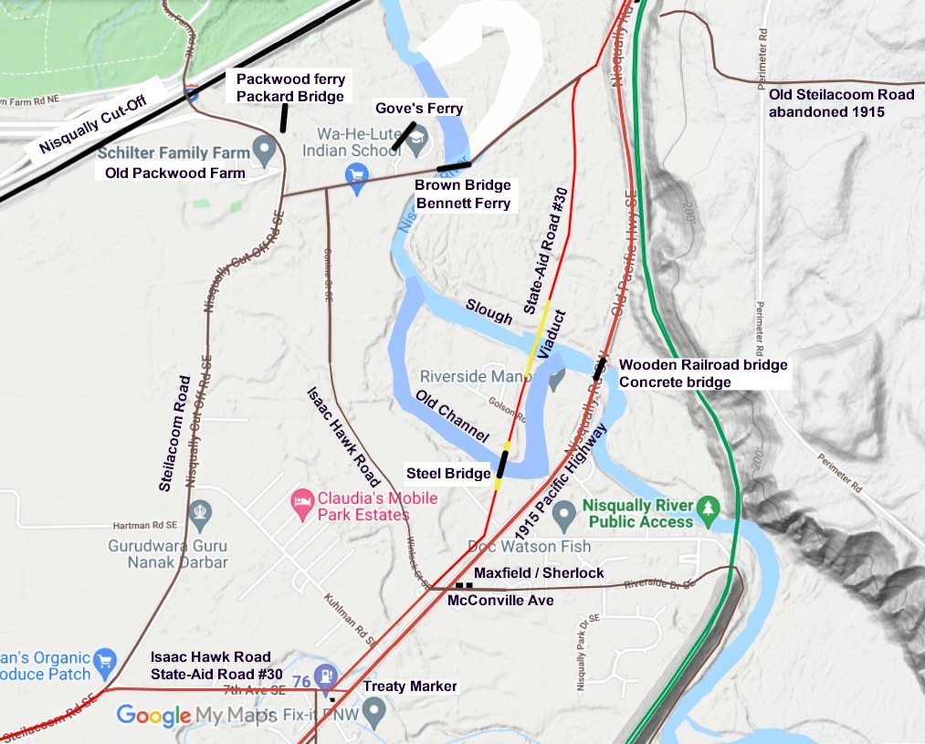
The Packwood / Packard Ferry
In the summer of 1853, William Packwood established a ferry across the Nisqually river at the Lower crossing. Packwood knew this road would be important and financed the operation using his own funds and having no authorization from the Territory. At the time, Olympia and Steilacoom were the largest towns on the Sound, and this road would be a vital link between them. There were people coming from; Tumwater, Olympia, Monticello and the Cowlitz Landing, who were using this crossing as they traveled north to Steilacoom and Fort Nisqually. Traffic on the road would continue to increase with each passing year. The new ferry eliminated travelers from having to take the much longer route via the Upper crossing which could add up to 15 extra miles to the trip.
The ferry was popular but the road across the bottom was terrible and during the rainy season it would be a sea of mud making travel very difficult if not impossible. McAllister's creek, which is at the bottom of the steep 8% grade coming from Olympia had to be forded. One of the first improvements to this section of road was on July 22, 1854 when John W. McAllister was appointed Thurston county bridge commissioner and he was authorized to let a contract worth $100 for a bridge to be built across McAllister's creek.
On January 20, 1855 after a week of heavy rain, the Nisqually river overflowed its banks and Packwood's ferry was washed away. The raging waters also cut a new channel destroying the road. The only communication between Olympia and points north was by boats and canoes. On January 29, 1855 McAllister received formal authorization to operate his ferry when the Legislature passed into law House Bill #52 officially granting William Packwood exclusive authority for the next 10 years to establish and keep a ferry across the Nisqually river.
A year later in January of 1856, after the war had just begun, Packwood along with his ferrymen were mustered into a company with Packwood as the Sergeant. The company consisted of; William Packwood, John W. McAllister, S. N. Woodruff, W. J. Yeager, Thomas Owens, Joseph Bunton, George W. McAllister, Samuel Wilson, Fayette McCarty, Joel Myers, and George Spurgeon. Their mission was to build a blockhouse and protect the ferry from attack, while keeping it in operation. Packwood's company would not last long and fell apart after barely a month of duty. The company was disbanded, and Packwood was sent to another unit. The reason for their dismissal was that out of the 10 privates; 6 refused to take the oath, 1 fell sick, and 3 refused marching orders.
John A. Packard, whose donation claim was on the Pierce county side of the lower crossing opposite Packwood was ordered to form a company and take over the operation and protection of the ferry. Packard's company operated the ferry from March 29, 1856 to September 22, 1856. The company consisted of; John A. Packard, John Myers, George I. Spurgeon, Thomas Owens, Joseph Bunton, John W. McAllister, George W. McAllister, George Melvin, and W. F. Parsons.
On January 18, 1859 the Territorial Auditor released a report of claims resulting from the war. The following was taken from the report concerning the Nisqually ferry; "William Packwood, who appears to have been the owner or keeper of a ferry on the Nisqually river, between Olympia and Steilacoom, was, by order of Gov. Mason, with his ferrymen, ten in number, organized into a company, Packwood having the rank of sergeant. They were mustered into service in January of 1856 and on February 2, 1856, the whole of the men were discharged for disobedience of orders, one for disability, and the rest for refusing to be sworn in. Yet the whole of them are reported for pay by the commissioners. Packwood went out of service on April 9, 1856."
"On the discharge of Packwood’s squad, in February, another similar squad, by order of Gov. Stevens, was mustered into service in March, under the command of John A. Packard, with Joseph Myers as corporal, and seven men. Packwood is reported in service until September 22, 1856 for which $374 is reported due him. The corporal and 5 of the men were discharged on the 18th of July, with pay to the amount of $222 each due the men, and $282 due the corporal."
"These men, Packwood and Packard, in addition to the pay above, have large accounts for ferriage over this ferry for numerous individuals, without designating whether they were in the service at the time or not, or even naming them so that fact could be ascertained. The fact of their being in the service, under pay, seems not to have made any difference in their charges for ferriage, and they, or one of them, besides, charged for a great many separate meals to various passing travelers, and to a heavy amount."
Packard's squad was discharged in late September of 1856 and it appears that William Packwood resumed operations of the ferry. It also looks as though someone wanted Packwood's ferry authorization revoked. This was because on Monday December 21, 1857 House Bill #16 an Act to repeal the Act granting William Packwood a ferry was read a second time and on motion from Mr. Meeker the bill was indefinitely postponed.
Packwood's authorization gave him exclusive right to operate a ferry anywhere within one half mile in either direction on the river above or below the Steilacoom Road. But there was nothing in the act to prevent someone from constructing a bridge at the ferry crossing. Sometime after September of 1856 John Packard, for whatever reason, decided not to ask for Territorial permission, and began planning for the construction of a bridge across the Nisqually river using his own funds. Construction of the bridge most likely started in the spring or summer of 1857.
On August 11, 1857 it was reported that John Packard's toll bridge was still under construction. The bridge was located immediately below Packwood's ferry, and was completed on January 29, 1858. The tolls were; man and horse, 25 cents; one yoke of oxen or span of horses and wagon, 50 cents; loose cattle or horses, 15 cents; sheep and hogs, 5 cents each. People on foot were free to cross at no charge. These rates were as the newspaper said; "100% lower than Packwood's ferry, which were set by the ferry act."
In January of 1860, Packwood petitioned to have his ferry charter amended to include a bridge. This bill would languish in the Legislature for the next 2 years before his bridge authorization would be granted. In the meantime, the Packard bridge would continue to carry travelers over the river until the rainy season of 1861. This is when the swollen river washed out the bridge. Packwood, who still had ferry authorization for 5 more years must have resumed operations of the ferry.
The following story may have been just a random act of vandalism, but On October 19, 1860 an article in the Standard told about some villainous scamp who had entered the orchard of William Packwood during the night and cut down 60 to 70 young apple trees, and girdled about the same number of older ones that were bearing an abundance of fruit. Not content with this, the rascal came again on a subsequent night, and ripped open some 20 odd bales of hay that were packed ready for shipping, and cut in pieces a large rope used in baling hay, and damaged the hay-press. The Standard said that; "Such acts merit the severest punishment. We can scarcely find language to express our utter contempt and horror for such a vile wretch, and it should be the desire of every good citizen to assist in ferreting out and bringing to justice every offender of this kind."
An article in the Steilacoom Puget Sound Herald on December 19, 1861 titled The Nisqually Crossing, sheds some light into what was going on during this time. The article said that the loss of the Packard toll bridge during the late freshet made them realize the importance of having a good bridge at the Lower crossing; "Unquestionably there has been no bridge in the Territory so much used by man and beast as this. To the citizens of Pierce and Thurston counties as well as to cattle drivers from Oregon, it has been the most useful of all our thoroughfares."
"It formed the connecting link between our two largest towns, to the citizens of which it has been the greatest public convenience they enjoyed. Since we have lost this convenience, we are forcibly reminded of its value, and of the important service which it rendered. It is known to but a few, we believe, how much the public is indebted to John A. Packard, the builder and proprietor of the Nisqually bridge, for the accommodation which it was afforded."
"Without waiting for or asking any legislative enactment to protect him, in order that the cost of the structure might be restored to him, he set about constructing it. It was enough for him to know that the public demanded it. He required no legal guarantees, and asked for no monopoly; trusting solely to the sense of justice of the public. He has no charter for the work, and never did have any. While this bridge was still in existence, any other person equally enterprising was at liberty to build another bridge, establish a ferry, or institute any other mode of crossing the Nisqually. Packard possessed no exclusive rights."
"An effort is now being made by another, we learn, to obtain not only a charter for a bridge, but also a most outrageous monopoly. This other party very modestly demands the exclusive use for ten years to bridge the river, and the prohibition of any one else from constructing a bridge or establishing a ferry within a mile on either side of him. He thinks he ought to have the whole loaf, and don't believe in doing things by halves. Such a proposition deserves but one fate, and that is to be summarily laid under the table. It does not merit a moment's consideration."
"Mr. Packard offers to reconstruct his bridge in a much more substantial manner than before, and asks no exclusive privilege. He requires an assurance of protection however, for five years, at the end of which time he will relinquish to both counties, for its actual value, wear and tear considered, all claim to the bridge. This is the true course. We hope at a period not more than five years distant, and much less, if possible, to have a free bridge across the Nisqually."
"We learn that Mr. Packard is now obtaining lumber for the new bridge, and has workers employed cutting piles for it. Mr. Libby's steam pile driver has been engaged, and all the necessary steps have been taken to complete the bridge in a few weeks. He has the facilities for the work now which he did not before possess, and can safely guarantee both a more speedy completion and a better structure than his rival. Let him have, then, his reasonable request granted, and in thirty days, at most, the new bridge will be perfected."
"While on the subject of a bridge, we can not forebear calling attention to the importance of improving the road through the Nisqually bottom, than which it is difficult to conceive a worse road. Cannot some enterprising citizen organize a company to construct a plank road on the bottom? Next to the bridge, a plank road is of the utmost importance. At times, during the rainy season, it is almost impossible for horses with riders or wagons to get through the mud of which the road is comprised. It seems to us that there is travel sufficient over this thoroughfare to justify such an improvement; and a more judicious expenditure of money could hardly be made, at least so far as a profitable return is concerned. We sincerely hope something will be done this winter, to improve the condition of the road through Nisqually bottom."
On December 21, 1861 during the Legislative session John Chapman presented a petition from John Packard who was asking for a charter to keep a toll bridge on the Nisqually river. The petition was accepted and then sent to the committee on Corporations. On December 28, 1861 the committee on Corporations gave their recommendation on granting Packard a bridge authorization. The petition was then referred back to the House with a recommendation that it pass.
On January 7, 1862 Packard's toll bridge was approved. The rates were; horse and rider, 25 cents; a single horse and carriage, 50 cents; one yoke of of oxen or a span of horses and wagon 75 cents; each additional span of animals was 25 cents; loose stock other than sheep and hogs 10 cents each; and for sheep and hogs, 5 cents each. People on foot were no charge. Packwood had 7 weeks to complete his bridge or his charter would be revoked. It appears that he was able to complete the bridge in the summer of 1862 and met the deadline.
On January 10, 1862 the Legislature approved 2 amendments to William Packwood's ferry charter. The first amendment took away his exclusive right of one half mile below the Steilacoom road and changed the half mile above the road to one mile in a straight line. This leads me to believe that Packard's bridge was just below the ferry. The second amendment was to grant Packwood the privilege of building a bridge, providing that his bridge be completed within 18 months. If he did not meet this deadline his bridge privilege would be revoked.
On January 28, 1862 The legislature gave authorization to John A. Packard and S. A. Hackett for the construction of a plank road across the Nisqually bottom between the bluffs on either side of the Nisqually river, and a good road be made on the hills leading to the bottom. The road had to be completed by July 1, 1863 or the act would become null and void. On February 1, 1862 the plank road authorization was read a third time and passed.
On January 10, 1863 during the Legislative session, Packard's bridge authorization was amended. The rate for people on foot was changed from free to 10 cents. Also during the 1863 legislative session, a law was passed which was designed to encourage the building of bridges and plank roads on the public thoroughfares throughout the territory. The first section of the act said that any person or persons having the right to the soil, or having the consent of the owners thereof, could build over any river, creek, swamp, etc. at his own expense, and shall receive such compensation in the tolls as may be reasonable.
On January 21, 1863 Packwood's ferry charter was amended again. The new amendment changed the time he had to construct a bridge from 18 months to 2.5 years, which pushed the expiration date to June of 1865. This would be 6 months after his ferry charter would expire. William Packwood would never construct a bridge or seek to extend his ferry charter after it expired. In 1867 he would sell his farm to Isaac Hawk and move to Olympia.
Gove's Bridge & Ferry
Near the end of 1854 Captain Warren Gove and his wife Hepsibah claimed land on Ketron Island and another parcel near Steilacoom. Their land patent was issued on December 3, 1859. In 1862 the Gove's purchased John Packard's claim and all or part of Joel Myers claim. In 1864 Gove became the postmaster of the Nisqually office.
On January 28, 1864 the Legislature amended Packard's plank road charter and struck out the name of S. H. Hackett and inserted the names of Warren Gove and J. D. Laman. They also extended the time they had to complete the road until January of 1865. This tells me that the plank road had not yet been constructed or very little work had been done. It is unknown to me if the road was actually planked.
The following year the Packard bridge began to fail. On November 25, 1865 it was reported; "that the bridge over the Nisqually river on the road between Olympia and Steilacoom is in such a rickety condition that it is absolutely dangerous for loaded wagons to cross it, especially at this season of the year, when the constant rains have increased and swollen the waters in the river. It seems to us, that the proprietors of the bridge, being compelled by law and by the terms of their charter, to erect and maintain a good and sufficient bridge, should have some regard for the safety of persons compelled to travel that route, and put the bridge in good repair at an early date."
Packard would not repair his bridge, and it looks as though he had given up the bridge and ferry business in 1864. It was during this time that Captain Warren Gove took over the operation of the ferry while he repaired the rickety bridge.
At the end of 1865 or early in 1866 Captain Gove had rebuilt Packard's old bridge and began charging tolls. I found a court record from 1867, Gove vs Hays, where Captain Gove tried to sue Logan Hays for unpaid tolls, but was unsuccessful.
On November 27, 1869 during the Legislative session, Mr. Clarke introduced C. B. #74 an act to locate a Territorial road from McAllister's bridge in Thurston county by way of Gove's bridge or ferry to Tacoma, in Pierce county, to Snoqualmie Prairie, in King county. This road was to link Olympia and Steilacoom with the new wagon road over Snoqualmie pass at North Bend by following the old trail which ran from Auburn to Jenkins prairie at Covington, and then up the Cedar river to Rattlesnake prairie (now a lake) and then down the hill to North Bend.
This ancient Salish trail was used by the Hudson's Bay Company in the 1840's, the U. S. Army in the 1850's, gold miners in the 1860's, and livestock from the 1870's to the 1910's. It would take almost 100 years before this road would become a reality. In 1960 State Route 18 was opened between Auburn and North Bend. This highway does not travel up the Cedar river to Rattlesnake lake because of the watershed, and instead crosses over the hill 6.5 miles to the northwest at Tiger mountain.
In January of 1869 during a hard winter storm, the Gove bridge was washed away. The Nisqually river had flooded the bottom land which changed the course of the river where the bridge had stood. There were now 2 channels leaving the east end of the bridge on an small island. The new crossing would have to be moved east about a quarter mile to avoid the island. Captain Gove would resume ferry operations at this new crossing. In February of 1869 Captain Gove was formally issued a license by Thurston county to operate his ferry.
In 1869 the Legislature had revised the laws pertaining to bridges on public roads. The new law said that to construct a bridge on a public road, the counties had to appoint a person as bridge superintendent who would supervise and approve any bridge or any repairs made to a bridge on a public thoroughfare. Any bridge to be constructed or repaired over any stream or river which is the boundary line between two counties were authorized to untie for the purpose of building or repairing such bridge. Because of the new law Captain Gove could not rebuild the bridge.
The constant flooding of the river had finally gotten to the Gove's and they promised themselves to never spend another winter on the Nisqually floodplain. By the following year they had built a new home on higher ground.
In 1871 the Gove's decided to sell their some of their property on the Nisqually Bottom and move back to Steilacoom. The Gove's had owned land near the mouth of the river on the west side north of the Shazer farm, plus all or part of Joel Myer's donation claim, and all of John Packard's old claim. In 1871 August Charles Wolff Purchased 100 acres of the old Joel Meyer's claim from the Gove's. Today this would be just north of the freeway on the east side of the river. Wolff was there until 1874 when he sold his 100 acres to Joseph Klee and Friedrich Theodor Richter. This 100 acres would later be purchased by the Braget family.
Walker's Ferry
In 1874 Henry Walker purchased all or part of the John Packard's claim from Warren Gove. Henry Walker was a well to do farmer who was born April 15, 1829 and died November 25, 1905, and is buried with his wife in the Yelm Pioneer cemetery.
After purchasing the Nisqually land from Warren Gove in 1874, Henry Walker took over operations of the ferry at the lower crossing. Walker continued to operate the ferry until August 1, 1884. On February 15, 1884 the Washington Standard said that Henry Walker would be paid $100 for operating the ferry between August 1, 1883 and August 1, 1884.
In 1884 Henry Walker married Kitty Kautz who was the niece of Chief Leschi and the ex-wife of General Augustus Valentine Kautz. Kautz had fought in the War of 1855 and was an advocate for the release of Chief Leschi in 1857. General Kautz and Kitty had 2 sons Augustus Jr. and Nugen.
When the Civil War began, Kautz left Kitty to go fight in the war. He would never return to his wife and after the war he remarried and started a new life. Before he departed, Kautz had worried that Kitty would be unable to care for her sons and had Edward Huggins watch over them. Huggins placed Nugent in the home of Wesley and Catherine Gosnell, and in 1867 Huggins placed Augustus Jr. in the home of Warren and Hepsibah Gove. In 1873 Kitty Kautz married William Diggins.
In 1884 Walker had sold his land in the Nisqually Bottom to Samuel Y. Bennett and moved to the Yelm Prairie with his wife Kitty where they remained the rest of their lives.
The First Attempt to Build a County Bridge
The first attempt to get the counties of Pierce and Thurston together to jointly build a bridge at the Lower crossing as prescribed by the new law was on November 8, 1873 when H. B. #144 was introduced by Mr. Ward. This bill would have authorized the commissioners of Pierce and Thurston counties to contract for the construction of a bridge on the Nisqually river. They hoped it would pass but instead the measure was referred to a committee. On November 15, 1873 H. B. #144 was read a second time and was referred again to a committee where it died. It would take 20 more years before the counties would unite to construct another bridge at the Lower crossing.
The Packwood farm
On March 10, 1867 William Packwood put his farm up for sale, consisting of 325 acres of land situated on the Nisqually bottom in Thurston county. The farm was two miles from the open channel of Puget Sound, with good steamboat navigation (tide water) to either end of the farm. The farm consisted of about 100 acres of cleared brush land, in a good state of cultivation, and had an orchard of 500 Apple, Pear, Peach, Plum, and Cherry trees.
The buildings on the premises was a two story dwelling house, 3 framed barns, that were separate buildings and equaled to one barn 50 by 120 feet, along with sheds attached, together with outhouses. Connected with the farmed land there was about 60 acres of tide-grass land, and 100 acres of fresh grass and brush land, that were fenced in for pasture. The remainder of the land was woodland, composed of Cedar, Maple and Ash timber. In addition to the above improvements, there was a good School house on the property, which belonged to Packwood. He was offering the farm for $2,500 and would give possession on the 1st of June 1867, or he would have taken $2,000 to retain the use of the farm with the present years crops and would then give possession on the first of October 1867.
Packwood sold his farm to Isaac Hawk in 1867 and moved to Olympia. That same year Hawk married Lizzie McAllister who was the daughter of James McAllister. Isaac Hawk operated the old Packwood farm successfully for 39 years raising all kinds of vegetables, including hops. On December 7, 1888 a carrot raised by Hawk, measured 22 inches in length and 6 inches in diameter at the larger end, and tipped the scales at 5.75 pounds. In the fall of 1904 Hawk sold his farm of 325 acres, known as the Packwood claim to Henry Hackman for $25,000 and moved to Colville in Eastern Washington. Hawk lived for 2 more years and passed away at Colville on Friday January 27, 1905.
The Shannon Farm
Between 1875 and 1879 the 1,100 acre Shazer farm on the Nisqually bottom was sold to George D. Shannon. George D. Shannon was superintendent during the construction of the Northern Pacific between Kalama and Tacoma and was one of the leading spirits in the organization of the Olympia Light & Power Company. He was appointed a member of the State Building Commission by Gov. Ferry, the duties of which he performed very acceptably.
For a time he was chairman of the Board of Trustees of the asylum at Steilacoom, and held that position until he resigned to accept a place tendered him by Gov. McGraw on the board of State Land Commissioners. He was vice president of the First National bank of Olympia, an institution of which he was one of the founders. The old Shazer farm would soon become known as the Shannon Farm. Not long after he purchased the farm, he began to build a dike around the property. Shannon ran the farm successfully until 1890 when he moved to Olympia and rented out the property to J. K. Ingram and Andrew Bennett. George Shannon would live in Olympia for more 6 years and he passed away at his home on September 2, 1896.
On April 8, 1904 Frank V. Donnelly who was acting for Seattle parties, purchased the Shannon farm, comprising of 1,187 acres from Balfour, Guthrie & Co. The Seattle party was Alston Lennon Brown and afterwards the place became known as the Brown Farm. Farmer Brown would continue to dike in the land and he operated the farm very successfully until 1919. These dikes would be breached in November of 2009 to restore the estuary now known as the Billy Frank Jr. Wildlife refuge.
The New Channel Redux
In 1879 during a terrible storm the Nisqually river overflowed its banks which again changed the course of the river. This change dried up the channel where the ferry had crossed. The new channel ran directly north between Packwood and Packard's old donation claims about a quarter mile east of the ferry crossing. On August 15, 1879 the Washington Standard said that a new ferryboat was put into service at the Lower crossing.
The Bennett Ferry
In 1882 Samuel Bennett Sr. and his wife Sarah purchased the southern portion of the old Packard claim. In 1883 Bennett purchased the remainder of the Packard claim from Henry Walker. Walker continued to operate the ferry until August 1, 1884 when Samuel Bennett took over.
Beginning in August of 1884, the Auditor was authorized to pay Samuel Bennett $50 semi-annually to help him offset the costs of maintaining the ferry. Bennett would continue to operate the ferry for another 8 years until December of 1892 when Thurston and Pierce county finally came together and built a new jointly owned county bridge.
The Bennett's had 6 children; Samuel Jr., Donald, Andrew, Mary, Winthrop, and Laura. The Bennett's operated the farm for many years raising all kinds of produce. In 1886 Samuel's son Winthrop H. Bennett grew a cabbage which measured 60X63 inches and weighed 22.5 pounds. In 1899 Winthrop became a deputy game warden when he was vested with the authority by Sheriff Billings to look after the interests promoted by the Rod and Gun Club at Sherlock, in the preservation of game.
Samuel and his wife Sarah lived on their farm for the remainder of their lives. Samuel Y. Bennett Sr. would pass away on September 9, 1914. His sons Samuel Jr. and Winthrop both continued to live on the farm until the Government condemned the land for the expansion of Fort Lewis. His daughter Mary married Alfred Golson who had a farm near Sherlock and they raised a family there. Laura would marry Frank Hartman who also had a farm at Sherlock.
Sadly in 1913 Laura was suffering from a mental illness and drowned her 9 month old baby in the creek by her home, and then tried to take her own life, but the barking dog alerted Frank to what was happening and prevented her from drowning herself in the creek. Her brother Winthrop then took her to the Asylum at Steilacoom. It seems that Laura got better and was released from the Asylum sometime around 1917 and lived the rest of her life with her husband Frank on the Nisqually bottom.
Nisqually City
In 1869 rumors began to spread that the Northern Pacific was to build a line from the Columbia river to Puget Sound. Because of the rumor, Olympia would experience a short lived boom that soon faded away after a couple of years when the Northern Pacific officially chose Tacoma for the terminus. Before the railroad announced their plans to build to Tacoma, Samuel Coulter, General Miller, and General McKinney who were all prominent Olympia residents began to make plans to build a new city to rival Olympia. They would then try to convince the railroad to build to the new town they named Nisqually City. When the Olympia residents caught wind of the proposal, they were obviously not thrilled about the plan and gave the proposed town the derogatory name of "Hogem."
On October 2, 1869 the Standard said that; "it was rumored that the Government has abandoned a part of the Nisqually reservation. So now the denizens of Hog'em will hereafter repose in comparative security against the incursions of the military superintendents."
In an article printed in the Standard on April 15, 1871 titled The Public Enemy, it admonished the trio for trying to start a town to rival Olympia; "At a meeting of Olympia citizens on Tuesday evening April 11, 1871 they became astonished to hear that 3 of the most wealthy and influential citizens of the town publicly avowed their hostility to a measure involving the future prosperity of Olympia, solely upon the ground that they were more interested in building up a rival town on the Nisqually bottom where nobody at the time lived. This was on land which they procured from the Government for that purpose."
"We would be recreant to our convictions of public duty to allow any personal consideration for these men or their social position to restrain us from publicly protesting against sentiments the moral of which would justify private robbery by gambling devices, or public plunder through the latches of the law; sentiments which set at naught all moral restraint and social obligations which are the basis of patriotism and all public virtue; and proclaim self-interest as the sole motive of human endeavor."
"How can men avowing such sentiments condemn Judas for embracing the only opportunity offered to make some money out of the position he occupied? He had the law on his side, and might have argued, as many professed ministers of the present day do, his loyalty to the Government as his motive for betraying his God, and the money consideration as only the legitimate reward of his patriotism. How can they heap ignominy upon the memory of Benedict Arnold for an act by which he only sought to benefit himself at the expense of his associate, by returning to allegiance which he had forfeited by rebellion?"
"These Olympia gentleman have a legal right to do what they will with their own within the bounds of the law, as had also the historical characters above named; but when they compass their own selfish purposes by acts which impoverish others and seriously injure every member of the community of which they are members, they become amenable to the moral law which condemns them as social traitors and a public enemy, justly entitled to the execration of all honorable men."
"That we may not be accused of presenting this case in stronger terms than the circumstances will justify, we will state the facts which nobody will deny; About two years ago, when some excitement was caused here by the change of the route of the Northern Pacific Railroad to the valley of the Columbia River, from which it could only reach Puget Sound at or near Olympia, a few greedy speculators conceived the project of securing a point near here where they could monopolize to themselves all the benefits of the railroad terminus by the ruin of Olympia."
"The place selected was on Nisqually Bay, about ten miles north-east of this place, and included an Indian reservation. The combination immediately entered all the contiguous Government land and sent persons upon the reservation to claim the same under the homestead law; these persons had the title confirmed to them by taking the usual oath of residence upon the land and design to occupy the same, though no residence was established and not a habitation exists upon the lands to this day."
"So palpable the fraud practiced upon the Government, and so manifest the unprincipled greed of the land-sharks composing this combination, that the paper town which represents the land thus acquired is known to the public only by the characteristic name of "Hogem," and its proprietors as "Hogemites." This is in brief the history of the attempt of a combination of citizens of Olympia secretly organized to promote their own selfish interests by the destruction of the town of their own residence and the ruin of their neighbors. In view of these facts in what other light can these men be regarded than as the public enemy?"
"By the summer of 1872 Olympia began to see some new construction that was not seen in the past 3 years. This was because the citizens of Olympia realized that the future of their town did not depend on it becoming a railroad terminus. It was thought that wherever the terminus was located there the town would also go. Out of this idea some comfortable little sums of money have been realized. During the years 1869, 1870 and 1871, Township 19 North Range 1 West was retailed out in acre and town lots, at prices that would be considered ample within ten miles of New York City."
"Railroad probabilities gave that township its value, and as soon as it was demonstrated that it had no chance for the terminus it was worthless. Purchasers of lots in Nisqually and other "cities" in Township 19 North, Range 1 West, had been worked up to a very high anticipation of what the terminus was to do for their property, and when the price fell from $50 and $400 per acre to nothing, it was the first practical illustration we had had of what the railroad could do towards breaking up a town by going somewhere else."
"Next came Township 19, Range 2 West, and while this township had the benefit of the railroad idea, its lands ran up in three weeks from Government price and no buyers, to $50 and $100 per acre. Solid miles of it were platted into additions and towns; and any of this land, from Olympia seven miles north, (the farther north the better,) was sought after and gobbled up at almost any price, from the day it became possible that the railroad would run to that township, down to the date of the announcement by Messrs. Sprague and Goodwin that the road would lead to and the depot buildings be erected upon the Wylie or Billings Claims."
"Two months have elapsed since this fact transpired, and we venture to say that there is not a mind conversant with our railroad history, no matter what inclination or interest may have been uppermost, but has been overwhelmingly disappointed in the results of that announcement. The occasion chosen for the communication, it will be remembered, was the 4th of July, and though nearly two mouths have gone by, and we hear every day through the press of the rapid and certain progress of the railroad towards its northern terminus, yet not an acre has been cleared, not a building has been erected, not a lot has been bought or sold, upon the Wylie or Billings Claims."
"As a practical result, we are seeing more clearly every day how little the location of a terminus can do toward a building up a new town in opposition to a long fixed and apparently natural order of things, without some special advantage that does not seem to exist in the present case. Olympia is improving simply because the practical necessities of business are more imperative than the most plausible schemes of speculators; because trade and commerce will run in their own channels until they find deeper, smoother and shorter ones."
Throughout its short existence, the town of Nisqually City would existed only on paper, and in the dreams of its speculators.
At the end of 1887 the Committee of Public Buildings and Grounds began to receive offers to relocate the Territorial capital to some other location. North Yakima, Walla Walla, Waitsburg, Seattle, Tacoma and other places in the state had submitted requests to make their town the new capital. On January 27, 1888 George D. Shannon decided to get in on the fun and introduced an act to locate the Territorial Capital upon the most eligible and central location in the Territory. Shannon said that his land on the Nisqually bottom fronting Puget Sound between the Nisqually river on the east and McAllister's creek on the west was the most eligible and central location.
He said his land possessed; "the climate of perpetual summer though surrounded by perpetual snow. Here the lover of Nature can admire his mistress to his hearts content. At no point in the Territory is the eye gladdened by scenes more grand. Pastoral fields stretch away to the ever restless sea; while on the West and North the grand Olympic range rears its jagged crest, snow crowned. On the East and South the magnificent Cascades the acme of grandeur, stands guard, while the grand old Rainer is never hid."
"It is from this "most eligible and central location" the grandest most unapproachable view of this incomparable mountain may be had; while the face of this lovely and pastoral field is bifurcated at right angles with many natural canals that could and should be declared to be the public highways, streets and avenues of the new capital of the Territory, thus making of the capital a modern American Venice, which under the kind skies, magnificent climate, the protection of the government, and its "most eligible and central location" will become the home of the good and beautiful and the abode of brotherly and sisterly love."
"I will deed to the Territory, by warrantee deed, conveying title in fee. Four hundred acres of the richest, most productive and fertile land, together with the finest trout fishing and duck shooting preserves in the Territory, for the use of said Territory as Capital grounds."
On December 27, 1889 the region was celebrating a prosperous year and the Standard said that; "Even old Hogem is beginning to revive, and a company will soon build a wharf and sawmill, and begin the sale of town lots there. The site is now better known by its proper name of Nisqually, but in 1870, when land speculators were banking on the location of the terminus at the point, it obtained the nickname of Hogem, doubtless from the rapacity displayed by its founders, which has since been its accepted designation by our older settlers."
On September 27, 1890 the plat for Nisqually City was filed by Daniel and Catherine Mounts. The city was to be located on their land in the west half of the NW quarter of section 34, Township 19 north, Range 1 east.
On March 22, 1892 George Shannon appeared in Olympia to buy some coal and horse feed. He was asked by a reporter about his proposition to develop the country on the Nisqually bottom, by building a railway from Olympia to a point near Nisqually City. Shannon said; "I have never yet said that I proposed to buy the new Naphtha motor or the horses used on the railway at Olympia. If I did, I think I could operate the road very successfully, for I am not new in the business."
The excitement and prosperity would be short lived and there would be no construction of any buildings at Nisqually City. The Panic of 1893 may have had a hand in its demise. On July 9, 1893, John McLeod, who had purchased land in the proposed town wanted to rid himself of the tax burden, and petitioned the Pierce county commissioners to vacate the 160 acres of land at Nisqually City. He objected to paying taxes on the empty lots.
The end of the dream for a great city on the Nisqually bottom came on November 28, 1897 when Pierce county officially vacated the plat of Nisqually City and fixed the valuation of the land at $1.50 per acre and the paper town was no more.
Tragedy at the Ford
On May 23, 1892 Homer Carron, better known as “Frenchy,” was drowned in the Nisqually river at the ford near the mouth of Muck creek on Saturday while trying to cross the stream. Carron, who had been in Olympia about 2 years prior, lived with Silas Wentz, on the top of Ayres hill. He was a teamster and owned several head of horses. He had been hauling shingle bolts at Roy, where he had two or three men in camp.
He hired a horse and wagon from a Nisqually, and on that fateful Saturday started for Olympia to hire somebody to cook for his men. When he came to the ford he was cautioned not to cross, but having done so the previous day, he failed to heed the warning of those standing on the shore. The recent warm weather, however, had melted the snow on the mountain to such an extent that the water was rushing down the sides, and the stream was rapidly swelling and rising. The men on the shore again cautioned him not to cross, but he didn't heed their warnings and started his horse into the river until it lost its footing and then began to turn back to the shore.
Carron again declined to yield to the protests of the bystanders, and was determined to cross, this time applying the whip. When out but a short distance the water became so deep that the animal’s feet raised from the bottom. and driver, horse and buggy went floating down stream. The buggy tipped over and Carron jumped out and managed to reach a sand spit a short distance down stream. On the edge of this he stood, waist deep in the raging water. When the horse and buggy came along, he grabbed the bridle, turned the horse to the spit and tried to un-harness it, but a sudden turn in the current caught the buggy and again carried the rig down stream.
Carron jumped on the horse’s back, thinking the animal would swim ashore. The current was so swift, however, that the horse and driver were powerless. They went down stream until they struck adrift. The horse, thoroughly frightened, commenced to kick. Carron clung to him, but the animal finally went down. When it came up again, Carron was still clinging to the animal. The awe-stricken spectators from the shore were powerless, and were horror-stricken when they saw the dying and struggling animal kick Carron.
Again the two went down and came to the surface, this time the horse’s feet upward, and Carron still clinging with a deathlike grip. For the third time the two disappeared under the drift, and that was the last seen of the unfortunate man. The buggy was completely shattered. Ropes were brought into use, and the horse was pulled out in the hope of finding Carron still clinging to him, but, he was not. The boys in the neighborhood made up a purse of $10 for anyone who would find the body. Carron was unmarried and was about 26 years of age.
The next day in the Seattle Post-Intelligencer the story changed slightly. They reported that the body of Homer Carron, a rancher, living near Muck, drowned while on his way to Olympia to secure a marriage license to marry a young lady of that place. Carron's body would eventually be recovered and given a proper burial. Was the excitement of obtaining the marriage license the reason Carron was so determined to cross the river that day?
The Golden Wedding
On May 1, 1920 Laura Hartman the daughter of Samuel Sr. and sister of Samuel Jr. and Winthrop Bennett wrote an article about the founder of Sherlock; "Mr. and Mrs. James A. Barkley were surprised that night by a charivari, consisting of cow bells, horns, tin cans, alarm clocks, etc. The noisy marauders were called in and treated to a very happy evening. Refreshments were served by Katie Carey, who has been with Mr. and Mrs. Barkley for the past 14 years. The "band" departed wishing the young couple many happy returns of the day. The following day Mr. and Mrs. Barkley had as guests for dinner: Samuel and Sarah Bennett, Gordon Bennett, Elizabeth Ellsworth and Laura (Bennett) Hartman."
"Mr. and Mrs. Barkley were married in Elliotstown, Illinois, in 1870, where they lived two years, moving to Colorado on St. Patrick's day in 1872. After 8 years they moved to Sherlock, Kansas where they resided 10 years, then came to Washington in 1890. James Barkley established the post office at Sherlock, afterwards called Nisqually, naming it after their last residence in Kansas. They moved to Tenino In 1897, and was in business there with my brother Samuel Bennett for a number of years, then they ran a bakery till 1914 when they purchased a home in Puget where they had the post office for a few years. They are at present very much concerned over the "Little Brown Hen," and have a very fine yard of Rhode Island Reds. Abundance of gladness on you. L. B. H."
Maxfield / Sherlock
In May of 1891 the Northern Pacific had completed its line from Lakeview to Olympia. In the Nisqually bottom on the Thurston county side of the river and just before the bridge, the railroad built a depot named Maxfield. Then in the summer of 1891 James A. Barkley established the Sherlock post office. Sometime between 1889 and 1892 James P. McConville and his wife Mary moved from Lakeview to Maxfield and purchased property near the depot.
On March 5, 1892 James McConville, established the Maxfield Hotel. In honor of the event an enjoyable ball was given that evening and everyone from around the area came and participated. The McConville's hospitality was unlimited. Fine music, excellent dancing and bounteous refreshments added to the pleasure of the evening.
To reach Maxfield, wagons from Olympia would turn right onto what is know 7th Ave SE after going down the steep 8% grade and crossing the McAllister bridge. At the end of 7th Ave. the road turned left and followed on the north side of the tracks to the intersection with McConville Avenue, which was the main street of Maxfield. The road to McConville Avenue was first known as the Isaac Hawk Road and was built in the summer of 1892. At the intersection with McConville Avenue, the Isaac Hawk Road turned left near the railroad's water tank and followed the banks of the river northward and connected to the end of what is now called Connie Avenue SE. The section between McConville Ave. and the end of Connie Ave. would be abandoned sometime between 1915 and 1920. Winlock Ct. may be on the old alignment.
In the spring of 1892 the residents of Maxfield were; James A. Barkley, William Luark, John E. Wood, F. L. Knight, J. B. Flynn, George D. Shannon, Isaac Hawk, David Hartman, E. F. Adams, James P. McConville, J. M. Newsum, Jacob Stampfler, Frank Hartman, Washington "Wash" Hartman, Robert Wiggins and the Bennett family. On August 9, 1895 J. C. Durgin arrived and purchased from the state the southeast quarter of section 16, township 18, range 1 east, at $12.50 per acre, $63.50 for improvements and $110 for the timber.
On December 6, 1895 the Maxfield Land Company was incorporated by James P. McConville, his wife Mary McConville and James A. Barkley. The company was organized to promote the general prosperity of Maxfield by engaging in any form of business which they deemed expedient. The company began with a capital stock of $24,000 which was divided into 240 shares of $100 each.
On May 15, 1896 the Northern Pacific changed the name of the Maxfield station to Sherlock. This is when the name Maxfield began to fade. The town that year consisted of a Train depot and section house, a post office and a hotel. Some of the new residents of Sherlock in 1896 were; Oscar H. Swanson, Carl Arenander, Charles F. Rehklan, Leonard Hawk, William Hartman and Tighe Mounts.
On July 14, 1898 James McConville was taken to the hospital after suffering from sun-stroke from working in his field. McConville was in the habit of working out in the sun without a hat and after several hours with his head exposed to the sun's rays he became ill. Unfortunately McConville would never fully recover and sometime between July 15 and September 29, 1898, McConville passed away. He left the bulk of his property to his wife Mary, and to each of his children, if he had any, would have received $10 on their 21st birthday.
In 1902 the town of Sherlock consisted of a train depot and section-house, a hotel, post office, and a general store. In the surrounding area was a creamery, various shingle mills, logging camps, dairy farms and general produce farms. Ole Gardner who owned and operated the general store in 1902 may have first opened for business in the late 1890's. The earliest Item I could find about him was from 1902. Sometime between 1899 and 1912 Gardner would purchase the Maxfield hotel from Mary McConville.
In the summer of 1906 Durgin road was established. J. C. Durgin was a dairyman and owned one of the largest dairy farms in Thurston county. That year he sold his farm to William L. Gray and William Seiskie, who continued the dairy business. The ranch was located a mile and a half south of Sherlock and consisted of 195 acres, 40 of which were under cultivation, and 33 dairy cows. The farm had electric power and all the modern equipment of the time. William Gray had been a resident of Sherlock for several years prior to the purchase of the farm and his partner had just moved to Sherlock from California.
On August 27, 1907 Thomas La Fave, who was an employee of the Union Lumber Co. had purchased the old John McAllister place, which included the town of Maxfield. McAllister's cabin was located at what is now the Riverbend Campground, which is across the tracks from Sherlock. J. D. Williamson partnered with him and La Fave said that they bought the land for farming purposes under their own management.
On November 17, 1911 the Chamber of Commerce asked the railroad if they could have their fast trains stop at Sherlock on flag, so that the residents there could come to town, do their shopping, and return home that evening. They hoped the railroad would add 5 minutes to the morning trip from Seattle to Olympia. The railroad was not interested in the offer and rejected the petition. Then on December 22, 1911 the State Railroad Commission ordered the Northern Pacific to add the 5 minutes and make Sherlock a flag stop. It appears that the railroad decided to play some games because the Standard said that afterwards the railroad began to run a miserable schedule of arrival and departure times.
On July 10, 1914 Alex Nelson appeared before the judge in Olympia on a charge of having been drunk and disorderly near Sherlock. The judge then threw him in jail until he could raise $300 bail. He was brought in to jail with a broken nose, which he sustained in an encounter with Deputy Game Warden Winthrop Bennett. Nelson's nose would be set by Dr. W. L. Bridgeford as he sobered up in jail.
Fire at Sherlock
On August 28, 1892 at about 3pm Sunday afternoon the dry house at the Card & Knight shingle mill at Sherlock caught fire. When an employee tried to sound the whistle, the cord broke, making it impossible to give the alarm instantly. The men grabbed a water hose thinking they could put the fire out with it, but it soon grew beyond their power. The cord was mended and the whistle sounded all over the country. Men ran from all parts to the scene of the conflagration, and soon there was an army of willing helpers with wet blankets and buckets of water to aid in saving the mill, which was but a few steps from the dry kiln.
Several dwellings and the cook house were badly scorched. Fortunately the river was near, and with plenty of help they succeeded in saving the mill and other buildings. Men were at work from 3pm until midnight carrying water. Some got their clothing burned, and badly scorched themselves, but none were seriously hurt. There were about 140,000 shingles in the kiln which were totally lost. The mill was situated on the west bank of the Nisqually river, on Samuel Y. Bennett’s farm, about a half a mile above the ferry.
Mr. Card and Mr. Knight were well-known and substantial shingle men, who possessed the esteem of every person in their employ. The enterprise was of great value to this section, and the proprietors had the sympathy of the people. The loss was about $3,000. The mill would be rebuilt and continued operations until 1912.
The Pierston Bridge
The first bridge built and owned jointly by Pierce and Thurston counties (Pierston) was built in summer of 1892. This bridge was located where the road (east end of Connie Avenue) crossed at Bennett's ferry. On March 10, 1892 the Standard said that; "it was altogether likely that a bridge will be constructed across the Nisqually on the road to Tacoma. At present, the only means of crossing it is by ferry. The Pierce and Thurston county commissioners will meet at Maxfield on April 7th to view a location for the bridge.
Then a month later on April 9, 1892 the commissioners of both counties came to the decision to construct the proposed Nisqually bridge at the point where the Bennett ferry now operates. Engineer Ouellette had departed Olympia on the 8th for the site and met with the engineer from Pierce county and together they took measurements of the proposed bridge and its approaches. On April 13, 1892 the board returned from a trip to Nisqually and said that the site they selected for the bridge, at the point where the Bennett ferry is now located was acceptable. Both counties would split the costs of construction and bids for building the structure were opened on June 6, 1892. After about a month on July 8, 1892 the bridge board had received 15 bids from contractors. The lowest bid was $2,000 and the highest was $5,880.00.
Construction began by the end of summer and everything was going as planned, but when the rainy season came that fall, the Nisqually river decided to show them who was the boss. On November 21, 1892 the bridge, which was still under construction, was partially swept away by a rise in the river. The Nisqually river let them off easy this time as the damage was not too severe and the following month the bridge was ready for traffic. On December 19, 1892 the county commissioners went out to examine the new bridge over the Nisqually river at Bennett's ferry, recently completed by the San Francisco Bridge Company at a cost of $2,800.
It only took a year before the river started to give the bridge problems and on January 19, 1894 repairs had to be made to the bridge. The following month on February 2, 1894 the Nisqually bridge was reported to be in bad condition. The commissioners inspected it on February 16, 1894 and they found that the main part of the bridge had settled, and ordered repairs to be made immediately. The repairs were quickly made and on February 23, 1894 they were completed and the bridge was back in good condition.
After a few more years the river had worn away the bank on the Thurston county side of the bridge and something had to be done to the structure or it would be lost. It was decided that wing dams should be built to protect the riverbank from erosion. The Nisqually river had always given them trouble on the Thurston county end of the bridge. The river made a very sharp curve just above the bridge, and the swift current flowed in such a manner that the Thurston county bank kept washing away, endangering the pier. Two jetties would be built, which directed the current to the center of the stream; one of these jetties was 180 feet long and the other was 100 feet long.
On March 27, 1896 the County Auditor received the plans for the contemplated protection of the Nisqually bridge. Bids were opened on Tuesday the 31st by a joint session of the Thurston and Pierce county commissioners at a meeting, which was held in Tacoma. On April 3, 1896 Schofield & Savage of Olympia was awarded the contract for the construction of the wing-dams. On May 15, 1896 the wing-dams for the Nisqually bridge were completed. It only took one season before the wing-dams needed some maintenance.
At the beginning of October 1897 the counties opened the bidding for a contract to improve the jetty at the Nisqually bridge. None of the bids they received were accepted and it would take 2 more years before anything would be done. On March 15, 1899 all bids to repair the Nisqually bridge were rejected as being too high and it would take another 3 years before a second round of bidding was opened. This time the bids they received were acceptable and on March 22, 1902 the repairs to the Nisqually bridge would be completed. Thurston county paid $601.80 for their share of the costs.
It appears the wing-dams did the trick as the bridge had no major issues for the next 4 years. The bridge no doubt had plenty of traffic and it continued to grow with each passing year. The wooden decking would began to fail after a decade of heavy use and some minor repairs to the span would be needed. On November 24, 1904 it was reported that the repairs on the Nisqually bridge had been completed, including the laying of new planking. The structure was now safe again for public travel.
By 1905 the old bridge was beginning to show its age and the river with its constant shifting did not help matters. By 1907 calls were being made to replace the old bridge, but the counties were not listening. On October 4, 1907 it seemed to the Standard that the Pierce county commissioners were trying to get out of repairing the Nisqually bridge by declaring it was now all on Thurston county soil, which the newspaper said was probably true from the shifting of the channel.
They then said that the Thurston county officials had also been equal to the emergency, and they said that; "they were playing a Roland for the Oliver by the determination to change the road for a new location a mile or 2 further up the river, were no such controversy could possibly arise." They concluded by saying that the present bridge was; "an old thing anyway and it would not be much loss if it should be carried away by the first freshet. Now we will see what our Pierce county friends will do."
It looks like the counties came together and on October 27, 1907 decided to jointly prepare for the reconstruction of the lower bridge on the Nisqually river. After another 2 years on January 22, 1909 the Thurston county engineer was instructed to examine the bridge over the Nisqually river and give a report on the condition of the bridge at the next meeting. At that next meeting on April 30, 1909 the engineer reported back that he had condemned the Nisqually bridge.
On May 17, 1909 during a phone conversation with the joint commission of Pierce and Thurston counties, they agreed to order specifications and let a contract for repairing the Nisqually bridge near Sherlock. This was due to complaints they received by the residents in that vicinity who had to travel over the structure. An engineer from Pierce county said that the repairs would cost about $1,000, and it was imperative that the bridge be fixed soon. On June 18, 1909 the urgent repairs to the bridge were completed at a cost of $734.
The old Pierston bridge would finally be washed away by the Nisqually river early in February 1910 and was last seen on April 3rd floating in Puget Sound. Traffic had to be rerouted to the Upper crossing at McKenna adding about 10 more miles to the trip. It would be about a year before a new bridge would be built at this location.
The Olympia - Tacoma Road
In 1910 Thurston county with the help of state funding constructed a new road between Lacey and Nisqually known as State Aid Road #30. This road was built to reduce the steep 8% grade on the west hill of the valley, improve the road across the bottom. Pierce county helped build a new steel bridge and long viaduct over the slough and a new wooden trestle, which eliminated a dangerous railroad crossing over the tracks. Although this structure would later prove to be fatal.
On Wednesday July 15, 1908 at the county board meeting a petition was presented by the Sherlock Land co. for the vacation of a part of the plat of Maxfield providing the company grant the county a right of way for a county road across a certain strip of land across the N. E. corner of said plat along a route which was to be chosen by the engineer. This right-of-way was for State-Aid Road #30, which ran on the old Isaac Hawk road to Sherlock. The right-of-way that was vacated was from the intersection of the Isaac Hawk road and McConville Avenue northeast to the river where a new steel bridge would be built.
When the Dupont Powder Works opened its new dynamite plant at Nisqually, a 3.5 mile section of the Old Steilacoom road had to be abandoned between Mounts road and the old 1843 Fort Nisqually site. On April 5, 1909 Pierce county announced they would shorten the road running between Tacoma and Olympia by surveying a new alignment from Lakeview north to the Northern Pacific tracks, and another road that would go around the base of Nisqually hill on a safer and better road. The steep grade on the old Steilacoom road up the east side of the Nisqually valley would be abandoned. This 11 mile section was not part of the State-Aid road.
The new highway reduced the grade on the east hill from 15% to 5%. To eliminate the railroad crossing a wooden trestle was built over the railroad track. Between this bridge and the Nisqually river a long wooden viaduct was built over the slough and low land. This slough is now the current channel of the river. At Sherlock just below the wooden railroad bridge over the Nisqually river, (now the Pacific Highway) a new steel span with wooden approaches was constructed. This bridge was built when the Nisqually flowed in a different channel. The bridge was located about a quarter mile southeast of the current Pacific Highway bridge.
After crossing the long viaduct and steel bridge traveling west, the road connected to the Isaac Hawk road, and followed the tracks (now the Pacific Highway) on the north side. The road then turned right and continued following the Isaac Hawk road (now 7th Avenue SE) to where it connects with the Steilacoom Road. After crossing McAllister creek, The new road turned left and began to climb up a newly constructed 4% grade. This section would be abandoned in 1915. At the top of the hill (just past McAllister Ct SE on SR-510) a new road was built (now SR-510) in a northwest direction to the old Steilacoom road just east of Lacey. This section became the Pacific Highway in 1913.
The Steel Bridge
On March 18, 1910 Thurston and Pierce counties decided to build a new steel bridge across the Nisqually river, just below the railroad bridge, and about a half mile above the old Pierston bridge, which was washed away back in February. On April 8, 1910 Bertelson & Sons of Tacoma, had secured the contract for the new Steel bridge. This was a joint project paid for by both Pierce and Thurston counties. The bridge cost $8,480 and was to be opened for traffic within 60 days and the project was to be completed within 100 days. The steel span was 208 feet long and included 100 foot approaches on either side, making it a 400 foot bridge.
On the Pierce county side a long wooden trestle was needed across the slough and low land. This slough is now the current channel of the river. The length of the trestle is unknown and could have been up to a 1,000 feet long. The trestle was not a part of the bridge contract and although the bridge builders were informed of this, they built the trestle anyway and submitted a bill for $915, which was quickly approved by the county. The Auditor refused payment, because any project over $200 was supposed to go through a bidding process. The issue quickly became a controversy with plenty of drama, although in the end the company would be paid.
On October 14, 1910 the new steel bridge across the Nisqually river was opened for traffic. State-Aid Road #30 was a vast improvement to the old Steilacoom road and did well for the next 5 years, but during the summer of 1915 the river was beginning to take its toll on the structure and the steel bridge began to sag. Pierce county engineer D. H. White said that a new bridge should be built at once. Nothing would be done to the bridge because at the time the Pacific Highway was under construction and the road was to be abandoned when the project was completed at the end of 1915..
The Steel bridge would sit abandoned until the end of 1917 before the counties decided something should be done about it. During a meeting of the counties in November of 1917 the commissioners decided to auction off the bridge on December 7, 1917. On the day of the auction nobody showed up to bid on it. At the beginning of January 1918, before the counties could decide on what to do next, the bridge was washed out. On January 18, 1918 during a meeting with the state highway board and the commissioners from Thurston and Pierce counties it was decided that since no bids were offered for the steel bridge that Pierce county would pay Thurston county $300 for their equity in the bridge and Pierce county would salvage the steel.
The salvage operation began shortly afterwards and on March 15, 1918 the wrecking crew had finished taking the last piece of steel out of the river. Alston Brown had to use his caterpillar tractor to pull out the heaviest of the pieces. The wooden approaches and the long wooden viaduct all succumbed to the waters of the river leaving no trace of the short lived road.
The Brown Bridge
In 1910 while the county was busy building a new road and a steel bridge across the river, Alston Brown and Winthrop Bennett, who were living on opposite sides of the washed out Pierston bridge wanted to rebuild it. This was because the new county bridge would make them drive 2 miles out of their way to cross over the river to get between their farms or to go to town. On June 27, 1910 the Washington Standard said that; "farmers residing on the Nisqually bottom had begun a movement to restore the old bridge damaged by the floods of last winter. The remnants of the old structure were purchased for $11 at a county sale and will be used for rebuilding."
Also that year Alson Lennon Brown, who owned the old Shannon farm and Winthrop Herbert Bennett, who now owned his father's property along with his brother Samuel Jr. filed with the Secretary of State, articles of incorporation for the Nisqually Bridge Co., of Sherlock with a capital stock of $5,000. This company then rebuilt the bridge using the old structure they purchased from the county after dragging it back up the river. The bridge was completed sometime in the fall or winter of 1910. The old Pierston bridge, which was never called by that name until this article was written, would then become known as the Brown bridge.
In November of 1910 a heavy rainstorm hit the area and after 4 days of continuous downpour a total of 6.67 inches of rain had fallen. The amount of rain that fell in such a short time was more than anyone had ever seen before. The Standard said that; "For the plentiful fall of exceedingly persistent and remarkably penetrating rain the experience of the last week is unparalleled." The normal rainfall for November back then was 8.95 inches, but it was exceeded that year by nearly 50%. It almost beat the total rainfall of the previous year when 19.99 inches fell.
The Standard also said the following about the storm on November 25, 1910; "One of the serious damages by the storm was to the new bridge being constructed on the Nisqually at the point where the old bridge crossed the river, was carried away Monday, at a loss of from $2,000 to $3,000. The new steel bridge built by the counties of Pierce and Thurston, and the railroad bridge a few miles above the one owned by the farmers, withstood the strain and are yet undamaged. The farmers' bridge, which was to have cost $10,000, is a total loss, so far as it was built. The building will, however, probably be resumed as it is deemed a necessity by many farmers living too far from the new county bridge. The old bridge was washed out last winter. The storm seems to have been quite general on the Sound."
In the spring or summer of 1915 the commissioners from Pierce and Thurston counties purchased the Brown bridge from the Nisqually Bridge company for $5,000. The bridge would soon be needed by the counties as a detour during the paving of the Pacific Highway and construction of the new concrete bridge over the Nisqually that was to begin several years later. The counties had the Brown bridge and the connecting road improved for the amount of traffic that was to cross over it daily between 1917 and 1919.
In 1916 Willie Frank Sr. father of Billy Frank Jr. who the wildlife refuge is named after, had to move onto 7 acres along the banks of the Nisqually opposite the Bennett's just above the Brown bridge. This was because his allotted land on the reservation was taken over by the Government for the expansion of Fort Lewis. His property would become known as Frank's Landing. Willie Frank, would exchange salmon and steelhead for various produce and dairy products from the Brown and Bennett farms. Billy Frank Jr. said he crossed the bridge every day to pick up milk from the Bennett's. In the 1970's the Nisqually community at Frank's Landing would become the center of another battle the Nisqually had to fight with the Government. This time it was over their fishing rights, which would lead to what is known as the Boldt decision in 1974. The decision entitled the Medicine Creek treaty tribes to one half of the fish catch on and off the reservation.
After the Pacific Highway was completed in 1919, the Brown bridge would continue to be used as a county road for about 25 more years. It was sometime between 1940 and 1945 that the piers on the Pierce county side gave way and were washed out by the cutting of a new channel, and the bridge fell into the river. The old Brown bridge would never be rebuilt and the road on the east side of the bridge to the Pacific Highway was abandoned.
The Tenino - Point Defiance Cutoff
On April 22, 1912 the Northern Pacific Railway was considering plans for a 4-mile cutoff on its Olympia-Tacoma line, which would eliminate the necessity of crossing the deep gully at the Nisqually river. George T. Held, attorney of the railroad, had appeared before the County Commissioners, to discuss the situation that day. It was thought that the adoption of the suggested plan would solve the problem of right-of-way for the new State highway and amicably settle all controversy regarding the same.
The action of the county commissioners was deferred for a time to ascertain the sentiment of the people about Sherlock, which was going to be side-tracked. Whether an interurban line, or a removal of the town-site to the route of the cut-off would constitute the means of relief, none of which ever happened.
On August 7, 1914 Ole Gardner tried to sue the Northern Pacific to stop the abandonment of the Olympia line across the Nisqually bottom. The old line would become unnecessary because of the new cut-off between Coylston and Nisqually station. He said it would in effect wipe Sherlock off the map. Nearly everybody living in the vicinity was indirectly interested in the suit. Gardner claimed that his property, consisting of 300 acres valued at $40,000 and his hotel business would be entirely destroyed if the line was abandoned. Sometime after but before the spring of 1915 Gardner leased his hotel to Mr. and Mrs, Nysrtom. In June of 1915 The Nystrom's sued Gardner after Mrs. Nystrom was injured from a fall. They said that Gardner failed to make the promised repairs. It is unknown how long the hotel lasted.
On November 10, 1914 the Northern Pacific completed the Tenino-Point Defiance cut-off. This new line, which cost $8,000,000 gave the railroad an almost level grade between Tenino and Tacoma. Construction began in 1914 and continued throughout the summer. On Saturday November 14, 1914 trains on the Olympia route used a part of the new line from Coylston to Nisqually, the new station, which was built 200 feet south of the overhead crossing and about a mile northeast of the old Sherlock depot, which had been abandoned.
On November 17, 1914 the Northern Pacific's new Tenino-Point Defiance cut-off was opened for freight trains between Nisqually and Tacoma. This was an important change for Olympia. The junction of the new line and the old Olympia line, was made at a new station called St. Clair. Switching crews would begin their shift at 8am and take the incoming trains at Olympia, Lacey and Union Mills during the day, and then taking the local outgoing freight to the main line late every afternoon. All trains were routed over the new line on December 15, 1914 except for the 2 local trains which continued to use the old line through Dupont. Passenger fares were reduced between Olympia and Tenino placing it on the 3 cents a mile basis, which made the one-way charge 45 cents instead of 75 cents.
The Proposed Scenic Highway
On July 21, 1916 a proposed scenic highway was presented to the public. This new highway would have followed the shores of Puget Sound from Tacoma to Olympia. President Frank C. Ross of the Pierce County Boulevard Association proposed to build a new scenic highway between Tacoma and Olympia over the old Union Pacific right-of-way along the Sound, which would open up a large territory that was not before easily accessible while furnishing a fine view of Puget Sound and the Olympic and Cascade mountains.
Boulevard associations similar to Pierce county's were organized in Thurston and King counties and the commissioners of the two counties and the state highway department were asked to co-operate in the construction of the proposed road. From Dupont the road was to run south along the bluff to an intersection with the old Union Pacific survey; thence westerly across the Nisqually river onto the dike built by Amos Brown of Seattle; thence to the mouth of McAllister's creek and from there along the abandoned Union Pacific right-of-way into Olympia. This proposal to build a scenic highway over a proposed railroad was proposed the the counties that it should never be built.
The Pacific Highway
On March 19, 1912 Judge Reid of the railroad presented a plan for a new roadway across the Nisqually bottom to the Thurston county commissioners. His plan was to take the Northern Pacific line to Olympia and convert the right-of-way into a state highway. It was proposed to attach the Olympia line onto the new Point Defiance line at the junction of the Point line and the old line, then go south down the new line a short distance then switch back to the old Olympia line, making a 4 mile cutoff. The Judge then said that; "If the commissioners take the old railroad bed for a state highway it would do away with the steep Nisqually hill on the west side."
The plan was enthusiastically accepted by the commissioners and after construction began on the Point Defiance cut-off in 1914, a large part of the abandoned right-of-way between Lacey and Nisqually was obtained for the new Pacific Highway. This acquisition enabled the department to secure a location for the highway between these points on a practically level grade, eliminating the dangerous Nisqually hill on the old road. On February 26, 1915 the state authorized $50,000 to be spent on the Pacific Highway in Thurston county to eliminate the Nisqually hill between Union Mills and Sherlock by converting the abandoned Northern Pacific grade.
On May 3, 1915 a contract was put to bid for the clearing grading and draining of about 8.5 miles of roadway between Lacey and Nisqually. Bidders had to submit a certified check payable to the State Treasurer for 5% of the amount bid. The unsuccessful bidders would have their checks returned after the contract was awarded. At the end of May, the contract was awarded to L. H. Goerig of Seattle on a bid of $16,377.80. There were a total of 38 bidders for the project and the strong competition resulted in very low bids.
Construction began in June of 1915 and continued throughout the summer and fall. On July 1, 1915, the work on one half mile of fill on the east side of the Nisqually river in Pierce county was completed. The highway department had awarded this contract to the Northern Pacific because they had the tracks and the equipment necessary to do the work already on the site. The work on both sides of the river would be completed by November 6, 1915, and after the road was graveled it was opened for traffic early that December. The old wooden railroad bridge was converted for use by automobiles.
Tragedy on the Trestle
On Sunday April 1, 1917 a party motoring in a heavy rainstorm cost them two of their lives, those of Frank Pridmore and Mrs. Charles Runquist, a bride of only a week, and in the serious injury of a third, Nellie Pridmore. The tragedy occurred when the automobile in which they were riding skidded and plunged through the railing of the wooden viaduct over the Northern Pacific tracks on the east Nisqually hill and the car plunged 25 feet to the tracks below, just a few minutes before the afternoon train from Olympia arrived at that point.
Charles Runquist, the fourth passenger, was uninjured, being only slightly bruised. All the members of the party resided at Steilacoom. The incoming train was flagged by persons who happened to be at the Nisqually depot at the time, while others ran to give assistance. Nellie Pridmore was taken to Tacoma on the train and received treatment at the Tacoma General hospital for broken ribs and internal injuries. It was said that she had a chance for recovery, which she did.
The party had been on a fishing trip in Thurston county, and was returning to Steilacoom, when, running at considerable speed up the long Nisqually bridge through a driving rain, Pridmore attempted to make the sharp "S" turn on the overhead trestle. The front wheels failed to respond and the machine crashed through the guardrail. Pridmore was killed instantly and Mrs. Runquist died within a few minutes. Frank Pridmore was head of the laundry department at the Western Washington asylum and Runquist was head meat cutter. Mrs. Runquist had been employed as a nurse at the asylum until her marriage the week before.
Thankfully there were people only 200 feet away at the Nisqually depot who saw the wreck and quickly rushed to the scene. The train that was almost due was stopped before it crashed into the wreckage which had blocked the tracks. The sharp turns on the trestle had made the place where the accident occurred one of the most dangerous places on the highway in the state. "The front wheels skidded" said Runquist. "Pridmore knew the turn was there, but when he turned his steering wheel, the wheels of the car did not respond. They were stuck in a crack, then the car slid sideways along the boards. We crashed into the railing and went over." This would be the first and last serious accident on the old wooden viaduct, as it would be torn down and replaced by a new concrete bridge in the summer of 1917.
The Concrete Overhead Railroad Crossing
On June 4, 1917, the W. J. Murphy Company was awarded a contract to replace the dangerous 1910 wooden structure over the Northern Pacific tracks at Nisqually station with a new concrete bridge. This bridge was 351 feet long and 24 feet wide. The bridge deck made an angle of 52 degrees with the railroad tracks and joined the highway paralleling the tracks by easy curves of a 100 foot radius. The Northern Pacific contributed 40% of the cost and the project was completed on March 8, 1918 for a cost of $28,845.54. During construction, cars were detoured onto Mounts road and over the Brown bridge. Mounts road used to connect to the old Steilacoom road.
Arrested; One sack of Old Crow, bottled and bonded, somewhere on the Pacific Highway between Tacoma and Olympia. On October 10, 1919 the Washington Standard said that it would have been a a fitting title for the police record of a case, which was covered by Sheriff John H. Gilford and Tacoma officials. The story goes; at about 1am Saturday morning October 4th; Sheriff Gifford was called on the phone at his home. The person calling said that he had passed a wreck on the overhead crossing at Nisqually and that he believed there was booze in the car. Sheriff Gifford immediately left for Nisqually.
At about the same time that Sheriff Gifford received the call from Olympia, the Tacoma officials received a call from a soldier who said that he saw the wreck and that the people carried a sack of what he believed to be liquor up into the woods. When the officials arrived at the scene of the accident, according to Sheriff Gifford, there was a wrecked car standing on the bridge over the railroad track at Nisqually. The boy with the car stated that his mother had been in the car was injured so he sent her on to Olympia. He denied knowing anything about the liquor.
Sheriff Gifford and the Tacoma officials searched the woods just back of where the car was standing with flashlights and found a grain sack full of Old Crow whisky, bottled and bonded. This liquor was taken to Tacoma, as it was found in Pierce county. No arrests were made as the officers had no proof that the liquor belonged to the parties in the wrecked car. The owner of the car was John Doe McIntosh.
The 1917 overhead crossing would be replaced by a new concrete and steel structure in 1928. On July 12, 1928 contract No. 1243 was let to W. T. Butler of Seattle for a cost of $64,725.60. Work on the new concrete overhead crossing began on July 23, 1928. The bridge consisted of 2 - 70 foot steel plate girder spans with 275 feet of concrete, T-beam approaches with a 24 foot roadway. The project was completed by December of 1928. This bridge would be replaced in 2004.
Sherlock Shindigs
On Saturday August 11, 1917 a wild and exciting stag party was held out on the Miller ranch near Sherlock. The party lasted all day and throughout the night and fun was had by all. The next morning a few experienced a light headache by indulging in too much ice cream and pop. Also that Saturday a surprise party was held at the Hartman home and was given in honor of Hope, by Laura and Doris Hartman. Over 40 guests were present for the festivities. Dancing and cards were the main features of the evening. Ice cream, cake, coffee and sandwiches were served. In the wee hours of the morning everyone thanked the hostesses for a very enjoyable event.
The 1917 Winter Storm
On Sunday December 30th, 1917 after a week long rainstorm, which caused the rivers in Western Washington to overflow their banks, the swollen Nisqually washed out the old wooden Pacific Highway bridge. Cars would have to be detoured over the Brown bridge for the next 2 years until a new concrete bridge could be built.
To help protect the new bridge from being washed out, on January 4, 1918 construction began on rip-rap to protect the bank of the stream above the Pacific Highway bridge. Improvements would also made to the old Olympia-Tacoma road. This work was authorized by the county commissioners at a special meeting after the washing out of the Pacific Highway bridge. The Brown bridge was reported to be in good shape, but considerable work was needed to be done on the road so that it could carry the traffic between the two cities, while the river itself was said to be starting to cut a new course. To prevent the destruction of the bridge and protect the bank, a rip-rap was built.
The washing out of the wooden Pacific Highway bridge came as the result of the unusually high water in the Nisqually river, occasioned by the recent heavy rains and the unusually warm winter weather, which caused the snow to melt in the mountains. When the bridge went out it carried with it the pipeline which supplied Olympia with gas, and the company had to use the old local plant until repairs could be made. The flooding waters also tore out one section of the new high tension power line recently installed by the Olympia Light & Power company that connected with the Stone-Webster system.
At the time the highway bridge was washed out, the big railroad bridge at Nisqually was also endangered and the trains were pulled off the new Point Defiance line for a while and routed over the old main line through Yelm. Piles were quickly driven to provide protection for the piers and service was resumed in a few hours. The heavy rains also caused a big slide on the new line between Plum and Tenino, and a small slide at Nisqually hill, but the railroad crews soon cleared them away.
The Concrete Bridge
The destruction of the old wooden Pacific Highway bridge came just after the commissioners of Thurston and Pierce counties and State Highway Commissioner Allen agreed upon plans for the construction of a new concrete bridge at Nisqually and had already issued the call for bids a couple of weeks prior to the washout. The bids were opened January 14 and it was hoped that the contract could be let immediately and the work started as soon as possible. Construction of this bridge took several months, however, and during that period travelers on the Pacific highway between Olympia and Tacoma had to use the old road and Brown bridge.
On January 14, 1918, a contract was awarded to Hans Pederson of Seattle to build a reinforced concrete arch bridge consisting of two 80 foot and one 90 foot span over the Nisqually river near Sherlock. Construction began immediately. The work would continue all summer and into the rainy season.
On Wednesday October 23, 1918 Commissioner J. C. Sams announced that the new concrete bridge on the Pacific highway over the Nisqually river would be ready for use by December 1st, and the new paving on the Pacific Highway between the bridge and Union Mills would be thrown open to travel at about the same time. To permit the laying of the pavement during the rainy weather, Contractor Hardy covered long stretches of the route with canvas. Commissioner Sams said; "Opening of the new bridge and pavement will be welcomed by auto travelers between Olympia and Tacoma, who have been compelled to use the old road via the Brown farm ever since the old bridge was washed out early last winter. Contract for filling in the new bridge with 1,300 yards of gravel was awarded to Contractor Huber, who is building the bridge,
The architecture of the bridge was of the Luten design and in such a type the sides of the arches had to be filled to the level of the roadway. Gravel was taken from the riverbed, and the material being excavated straightened out the channel. The commissioners of the two counties agreed to jointly construct the fills of the approaches to the bridge. The approaches on each side were short, but deep, 2,000 yards of gravel being required on the Thurston county side and 1,400 on the Pierce county side. The bridge and road was not ready by December 1, 1918 as Sam hoped, and opened instead on January 22, 1919.
It only took 2 days for the new concrete bridge to be threatened by the river. On January 24, 1919 high water due to heavy rains the latter part of the week flooded the low lands and made it necessary for Pierce county authorities to clear with dynamite a log jam that had piled up against the Pierce county side of the new Pacific Highway bridge. Two feet of flood water was added to a sudden rise of five feet in the Nisqually as a result of the storm. Commissioner Allen had no fear of the new bridge itself suffering, but the approaches might have been washed away if the mountain floods had continued.
All the other streams in this section were running wild, but no damage of consequence had been reported. The jam at the Nisqually was lodged on the Pierce county side and extended out to the first pier. With the river full of heavy drift it presented a menace that called state and county road officials out of bed at 1am and kept them on guard all day.
On January 31, 1919 it was reported that the Nisqually bridge on the road between Olympia and Tacoma was in bad condition again as the river was eroding the riverbank. To repair and protect the bridge from further erosion of the banks, on August 4, 1919 Thurston county commissioners opened bids for the construction of a protection well along the west bank of the Nisqually river, from a point some 400 feet south of the old Brown bridge to a considerable distance below the new bridge. this was in order to prevent, if possible, the annual overflowing of the river bank during the winter, which endangered the new bridge.
The work began on May 23, 1919, and was finished on October 2, 1919. The structure consisted of a series of concrete piers, which were tied together with wire cables and built along the south bank of the Nisqually river above the bridge for a distance of 1,500 feet. The base of the piers were 17.5 feet square and varied in depth from 3 feet to 9 feet. The tops had the shape of the frustum of a pyramid 7 feet square on top, 12.5 feet square at the bottom, and 11 feet high. The work was performed by a state force at a cost of $19,948.28.
The Pacific Highway concrete bridge over the Nisqually river would last for 79 years when it was replaced in 1998.
Breakdowns and Mud Delay Many
Throughout the spring and summer of 1919 road crews were busy paving the highway on both hills leading into the Nisqually valley. This work was completed in August of 1919 leaving the only remaining unpaved portion between Tacoma and Olympia was across the bottom. Paving of this last portion had to wait until the new embankment had settled and became stable. The paving on this last section began in November of 1919 and was completed in January of 1920. During this time cars were detoured onto the Brown bridge and the old Steilacoom road.
On December 26, 1919 it was reported that: "travelers and drivers of automobiles between Olympia and Tacoma have been having a good deal of grief this week, due to rain-softened roads and an epidemic of engine trouble. Several times the Nisqually hill has been blocked by small cars which could not pull through the wet sand and occupied the center of the road until a long line of other machines formed and men from them lifted the troublesome car out of the mire. At times a team of horses, which were used on a county road scraper were unhitched and used to pull out cars."
"Shoe shiners and clothes cleaners in Olympia and Tacoma did a rushing business removing mud acquired while boosting cars along this road. Passengers on the bus which left Olympia for Tacoma Sunday at 5pm reached their destination at 10pm, but the bus remained on the side of the road at the bottom of the Nisqually hill until the next day, due to engine trouble. When this occurred the passengers were transferred to another car, but it also broke down, and a third machine had to be pressed into service."
"Some of the passengers on this stage had planned to take in a show at Tacoma, but as they did not arrive until 10pm there was only an hour before they had to return on the last bus. On this trip there was also trouble. Before leaving South Tacoma there were several stops for readjustments, and the engine was so weak that the driver did not dare to go over the sandy road on the Nisqually hill. Taking the detour, the bus was stalled at the bottom of the hill. Some of the passengers were fortunate enough to get a ride to Olympia in passing machines, and reached home shortly after 2am. The others remained on the road until much later."
The Completion of the Pacific Highway
On January 17, 1919 Governor Lister and members of the state legislature along with county officials took part in the opening ceremony of the new pavement east of Olympia. There was a film company who recorded the event. The dignitaries left Olympia at 2pm. There was a long line of vehicles led by a car containing Governor Lister,State Highway Commissioner James Allen, Chairman of the House J. C. Hubbell and SPeaker Fred Adams. in the following cars were Commissioners J. C. Sams, Samuel Y. Bennett and M. J. Neylon; Engineers Mannes and Yeager. Then followed a line of cars in which were filled with residents of the city and county.
The formalities attending the opening were conducted on a platform erected at the point where the new and old pavements join, Governor Lister delivered a short address. The Pacific highway was now paved from Olympia through Tacoma, Seattle, Everett and almost to Bellingham.
By 1921 the Pacific Highway between Olympia and Tacoma was a continuous concrete paved highway, and it would remain the main trunk road for the next 15 years. In 1936, the old Pacific Highway across the Nisqually bottom would be replaced with a new improved 4 lane road named the Nisqually cut-off, but today it is known as Martin way. The Nisqually cut-off would remain the main trunk road for the next 33 years when it was replaced by Interstate 5 in 1969.
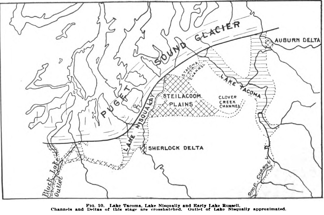
The Puget Sound Glacier, Nisqually Lake and the Sherlock Delta. 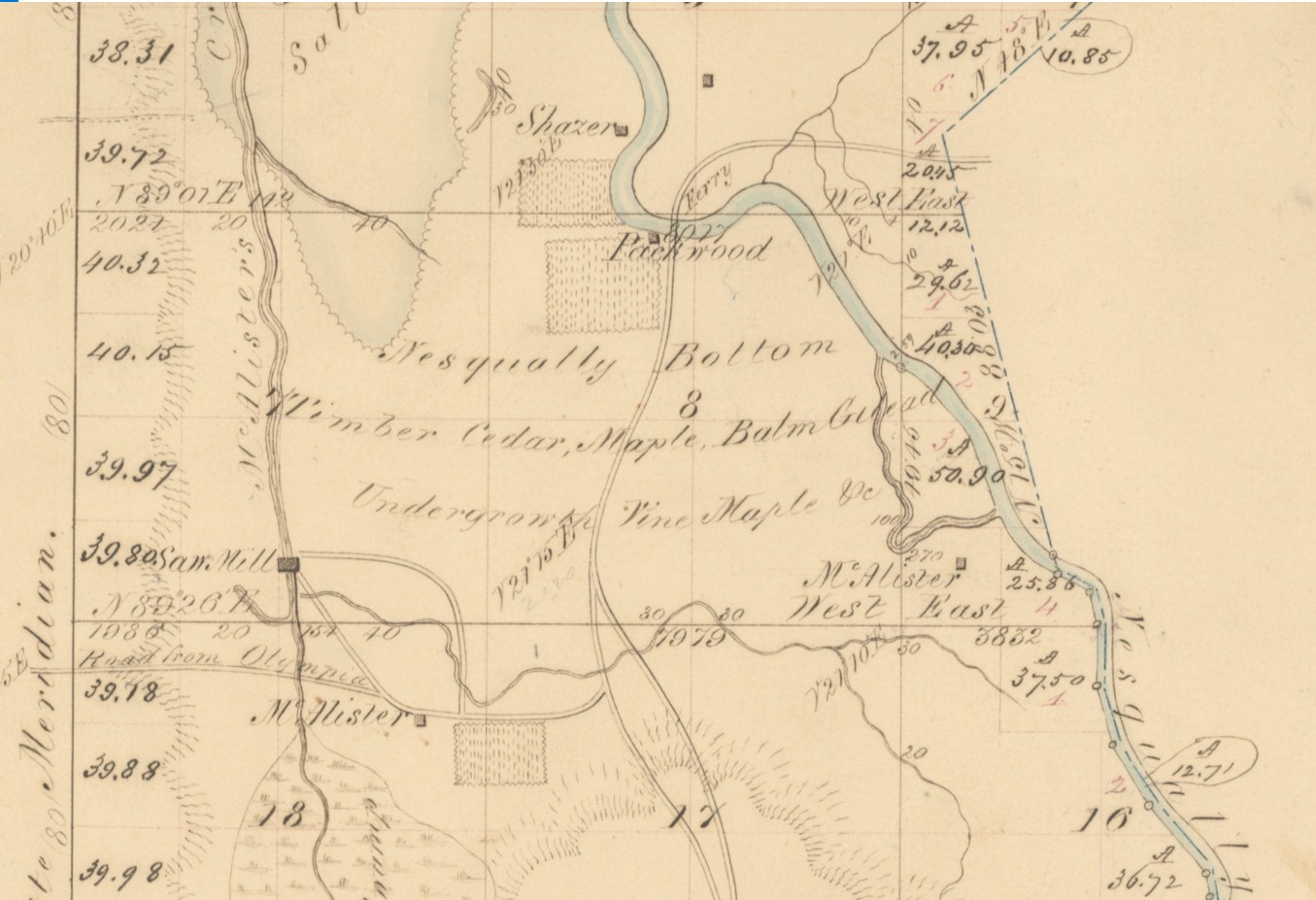
September 1853 survey map. 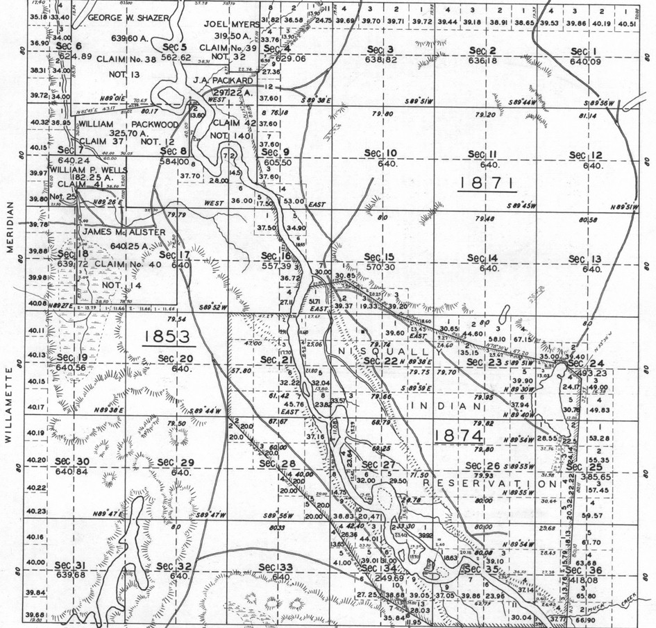
1853 survey map (Thurston county side) 1871 map (Pierce county side) Map shows the new channel and crossing. 
1910 map showing State-Aid Road #30. |
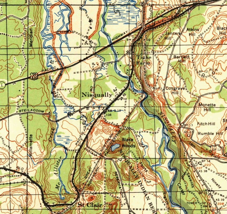
1940 USGS quadrangle map showing the old Brown bridge. 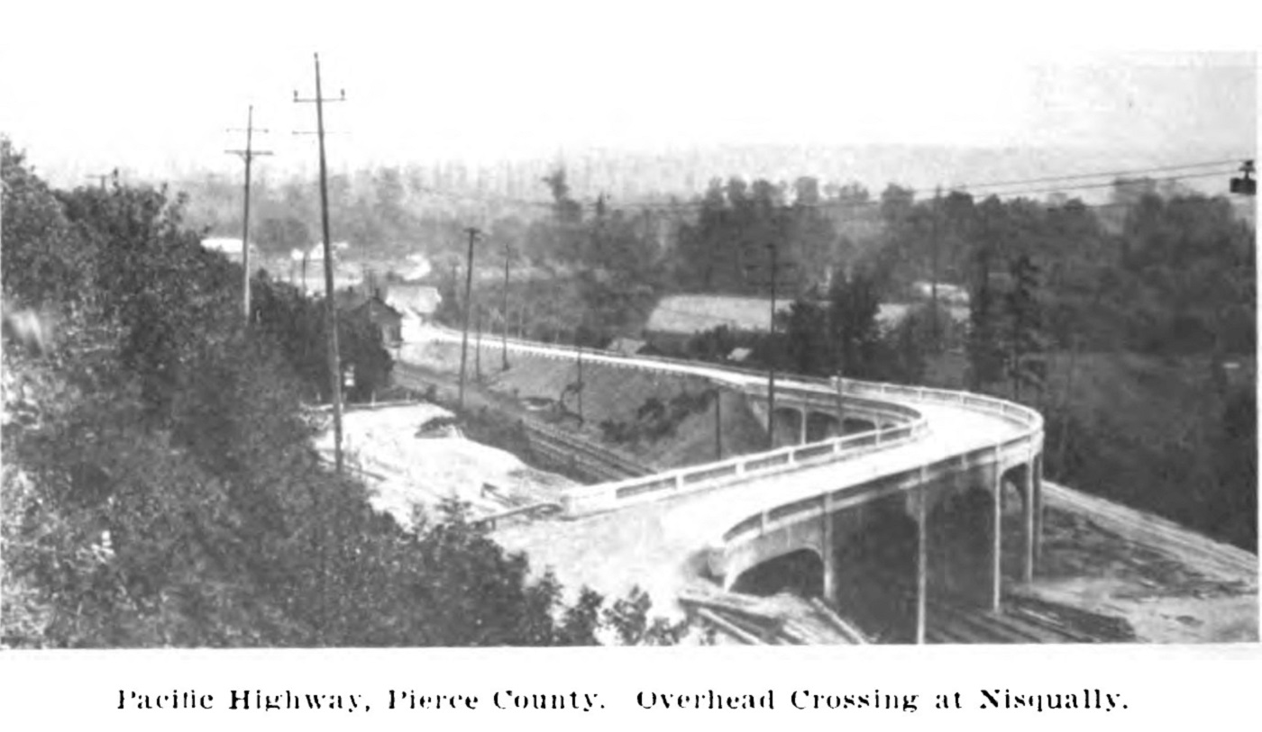
1920 state highway photo showing the new concrete overhead crossing looking southwest. You can still see a remnant of the old 1910 wooden trestle just beyond the eastern approach. 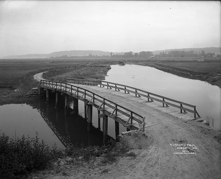
1913 McAllister Creek Bridge near the Brown farm. Photo courtesy Washington State Historical Society 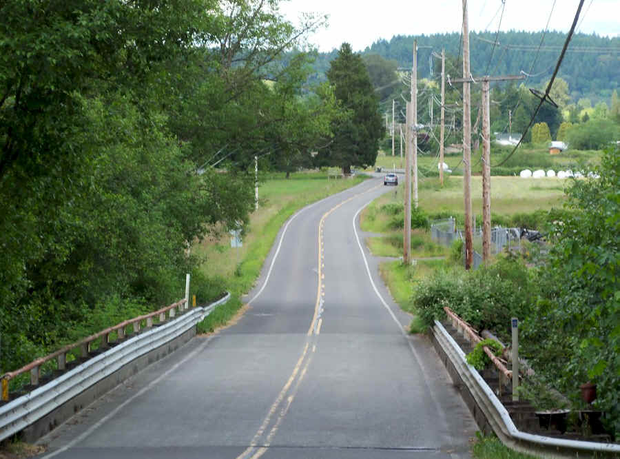
2011 photo of the McAllister bridge on the old Steilacoom road looking east across the bottom. |