![]()
The Historic Pacific Highway
in Washington
The Steilacoom Plains
![]()
The Historic Pacific Highway
in Washington
The Steilacoom Plains
History of the Steilacoom
Plains
By Curt Cunningham
Prairie vs Plain
Prairies and Plains both describe an
area of flat land, which is mostly treeless. Prairies are a type of plain,
which is mostly grassland. It is then safe to say that all prairies are plains
while all plains are not always prairies. The Hudson Bay Company Employees
referred to the prairies in the region as plains, which was sometimes spelled
in the old Washington newspapers using
the French word "plaine."
The Steilacoom Plains
The Steilacoom Plains, encompass an area of about 250 square miles and is located in south Pierce county between the Puyallup river on the north and east, the Puget Sound on the west and the Nisqually river on the south. The Puget Sound Agricultural Company's farms, ranches and sheep stations were all located within the Steilacoom plains, which they called the Nisqually plains. The Steilacoom plains consist of 8 smaller plains or prairies, which the British named; Puyallup plain, American plain, Dairy plain, Squally plain, Elk plain, Muck plain, Canadian plain and Long plain.
These plains were created during the Ice Age after the great Puget Sound glacier, which had advanced as far as Tenino, began to retreat. During this time the glacier deposited till hundreds of feet thick while leaving a scar on the surface. The scarring can still be seen in Thurston, Kitsap, and Pierce counties by using the terrain view of an internet map. The Washington State Lidar map is an excellent resource to view the surface of the plains. The scarring of the surface across the upper portion of the Steilacoom plains was eroded by the escaping waters from the Clover creek and South Tacoma channels, which drained westward across the plains during the retreat of the ice.
On December 20, 1907 printed in the Nooksack Reporter was an article that talked about the discovery of vegetable matter 1,000 feet below the surface in South Tacoma. On December 16th the city of Tacoma was drilling a hole at South Tacoma, and when it reached 1,000 feet below the surface they found the soil was similar to marshy mud and silt found on the tide-flats at Commencement bay. The formation was many feet in thickness and contained vegetable matter, showing that sometime before the Ice Age the area was covered with exuberant vegetation. The decayed plant life resembled those found in the tropics, and the tide mud was much like soft rubber. This evidence along with the fossils of palm trees which have been found in Seattle suggest without a doubt, that the Pacific Northwest was once tropical.
When Pierce county was still covered by the 1,000 foot thick glacier, the Puyallup and Carbon rivers drained through the Ohop channel and into the Nisqually river. Eatonville is situated near the southern end of this channel. The Nisqually river was blocked from the Sound and it emptied into the Deschutes river at Clear lake. The Deschutes itself was also blocked from the Sound and it emptied into the Skookumchuck river through the Tenino and Bucoda gap before the waters could reach the Chehalis river at Centralia.
Later as the ice retreated, the waters began to travel in the Scatter creek channel through Tenino and Grand Mound while on its way to the Chehalis. The Military Road, Cowlitz Trail and later the Pacific Highway run through this ancient channel. When East Olympia was uncovered, the Puyallup, Carbon and Nisqually rivers began to drain through the Spurgeon creek channel and across Bush prairie to the Black Lake outlet at Gate.
When the ice uncovered the Steilacoom plains, Lake Puyallup formed. This lake covered the valley between Fife and Auburn at the north end, and Orting at the South end. Lake Puyallup was fed by the melting Puget Sound glacier and the melting glaciers of Mount Rainier, which feed the Puyallup and Carbon rivers. This great volume of water, which had been draining through the Ohop channel now began to drain through the Clover Creek channel and across the Steilacoom plains. This is when Lake Nisqually formed, which later was absorbed into the great Lake Russell, the precursor to Puget Sound.
The Steilacoom plains is a large area of outwash gravels that possess a uniform westward descent from the broadening out of the Clover Creek channel near Spanaway Lake to the abrupt edge of the plains by the bluff of Puget Sound on the west. The grade across the plains drops between 10 and 15 feet to the mile. The surface consists of delta-like terraces in many places, and long channels that can be seen on lidar maps, which descend westward from Orting and South Hill before fanning out with the general slope at Spanaway. The coarse gravelly soil provides an excessive under drainage making the plains unsuitable for agricultural purposes. The Locals used to call the rocks "Lakewood potatoes."
Following the retreat of the ice from the "L" Street slope, which uncovered Tacoma, Lake Puyallup's waters found a lower outlet through the South Tacoma channel. The water crossing over the plains for awhile drained through both these inlets. The rushing water flowed into Lake Nisqually creating the Steilacoom and Sequalitchew deltas. It is theorized that these deltas had extended much further from the bluff than they do today. Chamber's creek has cut through the Steilacoom delta and Sequalitchew creek has cut through the southern edge of the Sequalitchew delta. The gravel pit north of Sequalitchew creek has been digging out the gravel from this delta for the last 100 years. Interstate-5 between Dupont and the Nisqually river runs down the southern outlet.
When Lake Russell formed at the later stages of the Ice Age, Lake Nisqually was absorbed. The escaping waters were now flowing through the Budd and Eld inlets into the Black Lake channel. This lowered the water level drying up the Clover creek and South Tacoma channels leaving the plains high and dry.
The First People of the Plains
The first people to inhabit the plains were the Steilacoom, Sastuck, Spanaway, Tlithlow, and Sequalitchew bands. These independent tribes are all related to the Puyallup and Nisqually people, and they arrived on the plains not long after the ice had uncovered them. These tribes would be the first on Puget Sound to be adversely affected by the encroachment of foreigners who would eventually take over their homeland.
The Steilacoom band lived at 6 sites along Chambers' creek near Steilacoom. The Sastuck lived in 3 sites along Clover creek, including the area that will become the City of Lakewood. The Spanaway band lived along the shore of Spanaway Lake where the town of the same name would be established. The Tlithlow band lived on Murray creek near where Hillhurst once stood, and the Sequalitchew band had 2 villages on Sequalitchew creek west of Fort Nisqually.
When the Hudson's Bay Company established the Puget Sound Agricultural Company in 1838 they began to hire members from these bands to help in the farming and ranching operations. Many of the European and Hawaiian servants who worked for the company would marry women from these tribes. Even thought the company was against the practice, Dr. John McLoughlin encouraged the employees to take Indian wives to help build trust and goodwill among them.
In 1854 Territorial Governor Isaac Stevens refused to give these bands their own reservation when he drafted the Medicine Creek treaty. This is because he thought Steilacoom would become the largest town on the Sound, and he did not want a reservation near this future metropolis. The people were then forced onto the reservations of the Nisqually, Squaxin and Puyallup. Many descendants of these bands continue to live in the area today, and in 1989 the Steilacoom tribe established a cultural center and museum in the town of Steilacoom that is open to visitors.
The Red River Emigration
In 1814, England and the United States had formally agreed to jointly occupy the Oregon territory after the signing of the Treaty of Ghent. This arraignment was supposed be a temporary fix until they could agree on dividing up the land between them without starting another war. This temporary agreement lasted 32 years before they could decide on what to do. The British wanted the international border to be the Columbia river, and the Americans wanted it much farther north than it is today.
In the late 1830's, to help bolster the British claim north of the Columbia river, the HBC began to ask their new retirees if they would like to settle on the land near where they had worked for years. In 1838 Simon Plamondon was the first British subject to take them up on the offer. His farm was located on the Cowlitz prairie west of the company's Cowlitz farm operations near Toledo.
HBC Governor Sir George Simpson said that; "It then became British policy but more especially of the Hudson's Bay Company to establish British agricultural colonies in Oregon north of the Columbia river the better to assure retention of that region. It had become manifest that the ultimate settlement of the question of boundary between the United States and Great Britain might depend upon occupancy of the soil by actual settlers."
The first attempt to start one of these British colonies was in 1841 when James Sinclair and Cree guide Bras Croche brought 200 settlers from the Red River District in Canada to the Pacific Northwest. The party had walked 1,200 arduous miles with no help from the HBC. Simpson said that; "The population consisted of Canadians, Orkneymen, Scotchmen, and their, mixed descendents who were mostly of Cree descent." The party arrived at Fort Walla Walla on October 4, 1841. When the group reached Vancouver, Dr. McLoughlin told them that the company could not honor the deal they agreed to. Dr. McLoughlin then said that if they go to Nisqually they will help out a little but if they go to the Willamette valley they will receive no assistance from the company
This obviously angered the emigrants who made a long dangerous journey only to be tricked by the company. A couple of the families decided to spilt off for California, while one family returned to Fort Edmonton. The rest of the party continued on north to the Cowlitz Farm where several more families remained. The remaining 13 families traveled up the Cowlitz Trail and arrived at Fort Nisqually on November 8, 1841. The newly arrived settlers were sent to Tlithlow, which was a company station east of Steilacoom. These emigrants only stayed for a year before packing up and moving to the Willamette valley. After their departure in 1842, company clerk Walter Ross took charge of the Tlithlow farm, and afterwards the place became known as "Ross Ville."
John Flett furnished the names of those who together with himself, wintered at Nisqually, in 1841-2; John Otchin, John Cunningham, an old man named John Tate, and Henry Buxton, an Englishman who had a wife, child and an orphan boy. (in 1882 Buxton was living at Forest Grove Oregon.) Next was John Spence and family (In 1882 the Spence's were living on the old Chambers' mill-site.) Archibald Spence and family, built a house on the Lowell place in 1882.
The three Flett brothers, James, John, and David with their families. John Flett was the only survivor in 1882, and was a strong and healthy old man beloved and respected by all who knew him. The Flett brothers and John Spence remained at Nisqually until June of 1843. Because the Company had failed to comply with their contract, these remaining emigrants along with their families crossed the "plaine," as it was called then, and traveled down the Cowlitz Corridor to the Columbia river and settled at Yamhill, on the American side.
William Flett and his wife, unrelated to the Flett brothers, was accompanied to Nisqually by his aged mother, Saskatchewan as described by Sir George Simpson; "She was here known as Mrs. Elizabeth Flett. She afterwards moved to Forest Grove Oregon, and was a consistent member of the Congregational Church, and died in 1853. Her daughter the aged widow Gibson, still lives near Nisqually." Next was Horatio Nelson Calder and Mickle Calder, along with his stepson Charles Wren. The Calder's moved to Hillsboro, Oregon and Charles Wren enlisted in the service of the PSAC at Fort Nisqually.
Two brothers, James and Alexander Birston, both were accompanied by families. Charles R. McKay and family (who were living in Forest Grove, Oregon in 1882)- Toussaint Joyal, and his son Joseph moved to the Puyallup Indian Reservation. Joseph Gaunyon and family, E. Bernier and family. There were 3 Red River settlers who did not cross the plains that year, who had accompanied the colony from Fort Vancouver to Nisqually, they were Thomas Hudson, William Baldro and John Johnson.
Of those who wintered at Nisqually, all left the area except for Charles Wren, who lived on Muck prairie. Wren was an ornery man and was feared by all the settlers. After his retirement, he moved to Victoria, British Columbia, where he died, in February of 1872. Henry Buxton, James Birston and Wife, Charles R. McKay and wife, Mrs. John Spence, who became Mrs. Taylor, were all residents of Oregon in 1882. The venerable John Flett who moved back to the Nisqually plains in 1869 was the only Red River colonist who was living on the plains prior to 1882. Of those who stopped at the Cowlitz prairie were the Le Roeques, father and son with their families along with the Bernier family.
St. Germain and family moved to Jackson Hill 10 miles north of the Cowlitz Landing next door to John R. Jackson. This aged patriarch had accompanied Sir John Franklin as interpreter in his first Arctic expedition. But a few years prior to 1882 he died at his home at the age of 105 years. And finally Mr. Le Blanc who moved back to the Nisqually plains in 1882. This emigration was the first and only attempt by the British under the auspices of the HBC to colonize the territory north of the Columbia river, which proved a failure.
The 4th of July Celebration at American Lake
In the summer of 1841 U. S. Navy Captain Charles Wilkes of United States Exploring Expedition sailed into Puget Sound and arrived at Fort Nisqually on May 11th of that year. Wilkes' mission was to explore the region for the U. S. Government. On July 4, 1841 the first Independence Day celebration held in what will become Washington State was along the the shores of American Lake, which was known at the time as Spootsilth Lake. Captain Wilkes described that interesting occasion; "Wishing to give the crew a holiday on the anniversary of the declaration on of our independence, and to allow them to have a full day's frolic and pleasure, they were allowed to barbecue an ox, which the HBC's agent had obligingly sold me."
"They were permitted to make their own arrangements for the celebration, which they conducted in the following manner. The place chosen for the purpose was a corner of the Mission prairie. (This was the prairie upon which Dr. Richmond and Mr. William. H. Wilson had established the Puget Sound Methodist Missionary Station.) Here they slaughtered their ox and spitted him on a sapling supported over the fire which was made in a trench. All was activity and bustle on the morning of the 5th, as the 4th fell upon Sunday."
"Before nine o'clock all the men were mustered on board in clean white frocks and trousers, and all, including the marines accompanied by music, were landed shortly after, to march to the scene of festivity, about a mile distant. After the rejoicings ended, the surveying party was again dispatched to complete the survey of Puget Sound."
The Early Settlement of the Plains
In 1844 Joseph Thomas Heath arrived at Fort Nisqually and took over an abandoned farm on Puget Sound Agricultural co's (PSAC) land north of Fort Nisqually and about a mile and a half west of Whyatchee station. His farm was originally a part of the Red River settlement, but soon after he moved in, it became known as "Heath's." Heath was one of the few British emigrants that arrived in the early 1840's to help colonize the area for England. Unfortunately after a few short years Joseph Heath would become seriously ill and he passed away in his cabin during the summer of 1849. Later that year the PSAC would rent out the Heath farm to the U.S. Army for the establishment for Fort Steilacoom.
Joseph Allard started working for the HBC in 1836 as a carpenter stationed at Fort Durham, also known as Fort Taku, which was located near Juneau, AK. In 1843, Allard was transferred to Fort Victoria, and in December of 1846 he was transferred to Fort Nisqually, and was sent to tend a farm on the Canadian plain a few miles south of Roy. It is unknown what happened to Allard, but it is theorized he left the area in 1849 for the gold fields of California. This is because in 1849, Francois Gravelle took over the farm near Roy. Gravelle was not a company employee, but was allowed to farm for himself and sell his excess harvest to the company at reasonable prices. In the Nisqually Journal of Occurrences on Wednesday, October 27, 1852, Dr. Tolmie made a bargain with Gravelle for 100 Bushels of Black Oats at $1.00 per Bushel.
South of Gravelle's place was the farm of Isaac Bastian, or Bastien. He was a retired PSAC employee who was allowed to farm for himself. His farm was on the Canadian plain about a mile south of Roy. Both of these farms produced an abundance of food for many years.
In 1840 at the age of 21 John Montgomery left his home in Scotland and signed up with the HBC. He then sailed to York Factory on Hudson's Bay. After the spring thaw of 1841, Montgomery joined the annual brigade and crossed the continent to Fort Vancouver. The party arrived at Fort Vancouver on August 24, 1841, and Montgomery spent his first month helping bring in the wheat harvest. On September 17, 1841 after the HBC had transferred all the company's livestock to the PSAC, Montgomery was ordered to drive the fort's livestock at Vancouver north to Nisqually. He arrived sometime in the middle of October of 1841.
When Montgomery arrived, Company Clerk Alexander Caulfield Anderson, who was at the time in charge of Fort Nisqually was preparing to leave on a trip south to Fort Vancouver. Anderson remarked that as he departed Nisqually for Vancouver, he saw sheep and cattle stretching all the way from Puget Sound to the Cowlitz river. After his arrival, Montgomery was sent across the mountains on the Naches Trail to Fort Walla Walla and drive back all the livestock which were kept there.
After his 5 year contract expired in 1845, Montgomery signed his second contract with the PSAC, and Dr. Tolmie sent him to Spanueh station. This was a cattle ranch located where the City of Spanaway will be established. Montgomery and his wife Betsy moved into a small hut near the shore of Spanaway Lake. Montgomery had said that; "We milked as many of the cows as we needed. They were all drive-able into a corral for marking and branding; sometimes we had difficulty driving in milk cows from the range." Montgomery's herd consisted of 3,000 head of cattle, around 200 horses and 8,000 sheep.
When John Edgar first began working for the PSAC, he managed Yanalacows station, which was located where the Joint Lewis-McCord airport now stands. In 1849, Edgar was transferred to the Yelm station, and in 1851 he retired from the company and claimed the land on the Yelm prairie where he had worked for the past couple of years. John McLeod began working at Whyatchee, which is where Lakewood now stands, and in 1850 he retired from the company and took a claim along Muck creek northeast of Roy.
The Squatters
By 1849, many PSAC and HBC employees began to retire, and some began to squat on the company's land. The first to do this was on the Cowlitz prairie when; E. L. Finch, J. H. Pierson, William Lemon, George Holsapple, Jackson Barton and a few others took claims on the company's land, and were promptly served with trespassing notices by the Cowlitz Farm superintendent. The following year these retired employees all claimed their land under the donation land act of 1850. When Dr. Tolmie found out there were squatters making claims along Muck creek, he immediately rode out to serve them all notices of trespassing.
Nobody took the warnings seriously and everyone remained on the land they claimed. Years later when the PSAC was on its way out, these squatters began to take the company's fencing and anything else they could get their hands on. The company was powerless to stop them, and would not try to bother them.
The first Americans to squat on PSAC land was in the late 1840's when Thomas W. Glasgow and Thomas Chambers arrived. In 1849 Fort Steilacoom was established at the old Heath farm for the protection of the emigrants who were beginning to settle on Puget Sound. The U. S. Government paid the PSAC $50 a month to rent the property. Fort Steilacoom would remain in operation and pay rent to the PSAC until 1868 when it was abandoned.
When the first Americans arrived at Tumwater in 1845 the PSAC wasn't too concerned about the encroachment of their territory as they saw it, but soon realized that these settlers were good for business, as long as they stay off the PSAC claim. But when PSAC land began to be taken over by these new arrivals in the early 1850's Dr. Tolmie knew that this was the beginning of the end for the company. In order to document the extent of the PSAC claim for when it became time to negotiate sale with the U. S. Government, Dr. Tolmie would serve trespassing notices to everyone who squatted on their land without permission.
All the retired employees
squatting on the plains who were still British subjects would eventually
become American citizens to take advantage of the land act. You did not
actually have to be an American Citizen to make a claim but only to have
intention to become a citizen in the near future. Dr. Tolmie kept a detailed
log known as the Nisqually Journal of Occurrences, and wrote the
following about the squatters; "Sunday November 4, 1849, Thomas
Chambers an American who arrived last night proceeded this morning towards
Fort Steilacoom where he is to mark off a claim in his son's name on the
Puget Sound Company's lands, and including mill-sites at the entrance of
Steilacoom creek."
"Monday November 5, 1849, rode out to Steilacoom today accompanied by
Walter Ross to warn off Thomas Chambers as a trespasser on the lands of the
Puget's Sound Co. Could not find Mr. Chambers who was tracing out his claim
in the woods. Accompanied Mr. Ross back to his home at Tlithlow."
"Wednesday November 7, 1849, called at Glasgow's in the morning and
warned him off as a trespasser on the lands of the Puget's Sound Company in
presence of Captain Mosher, Michael T. Simmons, Charles Ross and Adam
Beinston. Glasgow in his turn warned us against making any further
improvements on what he called his claim. Thursday January 10, 1850, wrote
Captain Hill at his own suggestion a letter which he is to enclose to
Governor Lane complaining of Glasgow's having squatted on the Company's
land and hoping that means may be taken to remove him."
"Thursday January 20, 1850, rainy. Work as yesterday. Four carcasses
beef received from the plains in the evening. Wrote Thomas M. Chambers
warning him that in marking off a claim at Steilacoom as he has lately
done, he is trespassing on the lands of the Puget's Sound Company. Copied
said letter to Mr. Chambers into the letter book. Monday July 22, 1850, sent
by Lapoitrie a written notice to Charles Wren that in settling at Muck,
Douglas river he is trespassing on the lands of the Puget Sound
Agricultural Company." These
notices would all be ignored and not one of these hardy pioneers budged an
inch.
In 1850 a half dozen retired employees made claims about 7 miles NW of Roy along the Douglas river. The Douglas river, was named for Sir James Douglas, Governor of the HBC, and is known today as Muck Creek. These squatters were; Charles Wren, John McLeod, Lyon A. Smith, John McField, and Henry Smith.
Henry Murray, emigrated to Puget Sound from New Brunswick in 1849, and the following year arrived in Olympia. While at Olympia Murray and John M. Swan constructed one of the first framed homes in the new town. In 1851, Henry married Catherine Ross who was a daughter of Chief Factor Charles Ross. Afterwards the newlyweds squatted on 640 acres along Muck creek, which they claimed under the Donation Land Act. They would be promptly served by Dr. Tolmie with a trespassing notice. The Murray's had 10 children and lived on their Muck creek farm for the remainder of their lives. Henry would pass away on June 30, 1908 and Catherine would pass on April 21, 1916.
Other squatters who received notices from Dr. Tolmie were; John McPhail in 1852 and Peter Wilson in 1853, both lived on the high Muck prairie. Richard Flandre and Jessie Varner who lived on the lower Muck were served in 1852. Aubrey Dean, George Dean, M. Clute and Joseph Legard, who lived on the south Muck, were all served in 1853. After Dr, Tolmie delivered his notices, the squatters would never be bothered again.
On April 4, 1850, the brig George Emory, which was owned by Captain Lafayette Balch, sailed past Fort Nisqually on his way to Olympia. The ship was carrying a cargo of general merchandise, which Balch was going to sell in the store building he was to build using lumber, which he had brought along with him. Balch thought the Olympia land owners would welcome him and make special arraignments to get him to locate there, but this was not to be the case, and he received a cold reception as the merchants there did not want any competition.
This became known to him after he had discharged all his cargo, which probably did not make him very happy to say the least. He had to reload his ship and then figure out what to do next. As he began to sail northward, he decided to establish a town of his own that would become a rival to Olympia. This new town would become known as Port Steilacoom.
On Tuesday December 24, 1850, Captain Balch arrived at Fort Nisqually aboard the George Emory. It took almost a month before Dr. Tolmie realized what Balch was up to, and then he wrote a notice of trespass, and delivered it to him on Thursday January 23, 1851. Dr. Tolmie said the following about his encounter with Balch in his journal; "I myself went by canoe to the Ship George Emory (lying to the Southward of Steilacoom Bay) and presented a letter to Captain Balch warning him that the claim he had there taken was part of the possessions of the P. S. Co. and advising him to make no further improvements thereon. He replied that he should take no notice of the warning and would still continue his improvements."
In the winter of 1850, John Butler Chapman moved from the Willamette valley to Grays harbor where he built a cabin and called it Chehalis City. His one-house "city," which will become the City of Aberdeen disgusted him so that he packed up and moved inland to Puget Sound. He arrived in August of 1851, and squatted on PSAC land about about a mile north of Balch's claim. He then proceeded to start another village that he dubbed Steilacoom City. Later the towns would be known as Upper and Lower Steilacoom.
On Monday June 14, 1852, Dr. Tolmie rode out to the Canadian plain, which is located south of Roy and handed a trespassing notice to Louis Seton. It is unknown who Seton was or where he came from.
In 1853 John Montgomery's contract expired and he decided to squat on a claim about 2.5 miles east of Spanueh station, which he had ran for years. Spanueh was the early name of Spanaway and originates from the word "spaduwe,” which means “where roots are plentiful.” During the War of 1855, Montgomery opened his farm to the U.S. troops for a military supply post named Camp Montgomery and fled the area until the hostility ended.
In the book, The Canoe and the Saddle published in 1862 by Theodore Winthrop, he describes his journey across the Pacific Northwest in 1853. The following is from his book as his enters the Steilacoom plains and arrives at Montgomery's cabin near Spanaway Lake;
"This was an evening of August, in a climate where summer is never scorching nor blasting. We breathe air as a matter of course, unobservant usually of how fair a draught it is. But tonight the chalice of nature was brimming with a golden haze, which touched the lips with luxurious winy flavor. So inhaling delicate gray-gold puffs of indolent summer evening air, and much tranquillized by such beverage, mild yet rich, I rode on, now under the low oaks, now over a ripe prairie, and now beside a lake fresh, pure, and feminine. And whenever a vista opened eastward, Tacoma appeared above the low-lying mist of the distance."
“Polikely, spose mika tikky, nesika mitlite copa Comcomli house;" (translates to) tonight, if you please, we stop at Comcomli's house, said Loolowcan the taciturn guide. Night was at hand, and where was the house? It is not wise to put off the choice of a camping ground till dark; foresight is as needful to a campaigner as to any other mortal. But presently, in a pretty little prairie, we reached the spot where a certain Montgomery, wedded to a squaw, had squatted, and he should be our host."
"His name, too articulate for Indian lips, they had softened to Comcomli. A similar corruption befell the name of the Scotticized chief of the Chinooks, whom Astor's people found at Astoria, and whom Washington Irving has given to history in his book. Mr. Comcomli was absent, but his comely 'mild-eyed, melancholy' squaw received us hospitably. Her Squallyamish (Nisqually) proportions were oddly involved in limp robes of calico, such as her sisters from Pike County wear. She gave us a supper of fried pork, bread, and tea. We encamped upon her floor, and were somewhat trodden under foot by little half-breed Comcomlis, patrolling about during the night-watches."
The next morning Winthrop and his guide Loolowcan departed for Naches pass.
In the fall of 1854 Ezra Meeker had left his home in the Puyallup valley to rescue some of his relatives who were coming over the Naches Trail, and were short of provisions. After reaching the party and bringing them back over the pass, they made a stop at Montgomery's. Meeker said in his book Pioneer Reminisces of Puget Sound that; "People now traversing what is popularly known as Nisqually plains, that is, the stretch of open prairie, interspersed with clumps of timber, sparkling lakes, and glade lands."
"From the heavy timber bordering the Puyallup to a like border of the Nisqually, you will hardly realize that once upon a time these bare gravelly prairies supplied a rich grass of exceeding fattening quality, and of sufficient quantity to support many thousand head of stock, and not only support but fatten them ready for the butcher's stall. Nearly half a million acres of this land lie between the two rivers, from two to four hundred feet above tide level."
"The beds of the rivers mentioned, undulating and in benches, form an ideal park of shade, and open to a land of rivulets and lakes, and of natural roads, and natural scenery of splendor. So, when our little train emerged from the forests skirting the Puyallup valley, and came out on the open at Montgomery's, afterwards Camp Montgomery, of Indian war times, twelve miles southeasterly of Fort Steilacoom, the experience was almost as if one had come into a noonday sun from a dungeon prison, so marked was the contrast."
"Hundreds of cattle, sheep and horses were quietly grazing, scattered over the landscape, as far as one could see, fat and content. It is not to be wondered that the spirits of the tired party should rise as they saw this scene of content before them, and thought they could become participants with those who had come before them, and that for the moment rest was theirs if that was what they might choose."
In 1883, John Montgomery had 14 horses, 9 cattle, 150 sheep and 75 chickens. He also grew 40 bushels of wheat per year. After the war John Montgomery returned to his farm and lived for the next 29 years. He passed away on November 23, 1885.
After 1853, more American settlers in even greater numbers began to arrive on the plains encroaching even more on the PSAC lands. These newcomers had no respect for the PSAC and they took whatever they could get their hands on. The PSAC dared not try to fight back as a war would surely have begin. These American farmers would carry guns with them when they were out working in the fields.
The disrespect by these newcomers was not confined to the British company. The Indian people who had been coexisting all this time with the company employees and the early American settlers, where marriages between them were common, began to disrespect them as well. The taking of the land that had been home to a people for thousands of years along with the many depredations made by some of these newcomers would lead the region into war.
The War of 1855
When the War of 1855 broke out, the American citizens fled to the blockhouses and forts for the next 18 to 22 months while life continued on as usual for the retired HBC employees who were living out on the plains. They were not worried as they knew no harm would come to them. The PSAC employees who were known to the tribes as "King George's Men" had long ago established good relations with the Indian people. It was the "Boston's" (Americans) that they were fighting against.
John Montgomery who was now 40 years old fled his farm after his wife and laborers were sent to the Squaxin reservation, while some of the laborers may have instead joined Chief Leschi to fight against the Boston's. John Edgar was hired by the U.S. Army as a guide and would be killed near South Prairie after crossing back over the mountains on the Naches Trail. Edgar Rock near Naches Pass was named after him.
Camp Montgomery would be established on November 6, 1855 as a supply depot, and was used by the military until the end of hostilities in Western Washington during the spring of 1856.
PSAC clerk Edward Huggins, who was now in charge of Fort Nisqually, moved to Muck station with a party of Nisquallys, Hawaiians, Englishmen and French-Canadians. He remained at Muck station until the hostilities ended. At first, the military did not have any issues with the former Hudson's Bay People remaining on their farms when all of the other settlers had fled to the forts and blockhouses. The military was even buying grain from some of them. Things would not stay cordial for long.
In the beginning of March 1856, Governor Stevens got word of a rumor going around that the Hudson's Bay People were giving aid to the hostiles. Stevens made an order on March 3, 1856 invoking Marshall Law in Pierce county, and then had all the Hudson's Bay retirees leave their homes and report to Fort Nisqually where they would be placed under guard. On March 6, 1856, Captain Maxon and his company arrived on the Muck prairie and arrested, John McLeod, Henry Smith and John McField, and a few days later, Henry Murray and Peter Wilson were arrested.
The 5 men were taken to Fort Steilacoom, and after they agreed not to return to their claims they were set free. Chief Leschi had arrived at McLeod's place before he was arrested and told McLeod he wanted to surrender. He was advised not to do that and Leschi disappeared into the forest.
Leschi would be betrayed and captured in 1858, and after 2 trials he was wrongly convicted and executed by hanging. The Army did not want the execution to be held on fort property, so the Governor had ordered his men to construct a gallows a mile away from the fort in a depression of land north of Steilacoom Lake. This location is just southeast of Oakbrook Plaza, on Steilacoom Boulevard somewhere along Leschi Rd. SW. A housing tract now sits on top of this historical place.
After the war, people began to move back to their farms and many had to rebuild from ashes. The anxiety of another attack would linger on for a year or so. The retired PSAC employees would continue on with their lives and the servants of the company would go back to managing their flocks and tend to their fields. The PSAC continued operations until 1869 when they sold all their property to the U.S. Government for $200,000. In 1870 the former land of the PSAC was officially opened to legal settlement.
On October 10, 1872 under the Land Act of 1820, Edward Huggins who was still living in the chief factor's house at Fort Nisqually paid $1.25 an acre for the 160 acres surrounding the fort. Huggins would continue to farm his land until 1906 when he sold his property to the Dupont Powder Works. By the 1930's all that was left of the old fort was the Chief Factors house and the granary. These buildings would be moved to Point Defiance Park in 1934 where the fort was rebuilt, and today is open for visitors.
The Muck Road
Travel across the plains was easy as there were very few obstacles that would block your path. The old timers said that you could go almost in any direction across the plains for 50 miles. The roads across the plains could be over 100 feet wide as the people traveling in wagons would avoid the deep ruts made during the previous rainy season. When the road met the forest it would narrow to about 6 feet, and after each winter these roads through the forest would have to be cleared of the downed trees blocking the path.
The first wagon road across the plains was constructed in 1833 when the Muck road was established between Fort Nisqually and Muck Station, which was located north of Roy along Muck creek. The Muck station was the principal headquarters for the PSAC out on the plains. At the Clark road entrance to the Lewis-McCord base, on the north side, is a row of trees lining both sides of a small 350 foot section of the old Muck road. Located in the area between this section of road and the entrance to the base is a historical marker. The marker is a rough granite stone with a bronze plaque created by Alonzo Victor Lewis.
The inscription reads; "This street from the railroad crossing at American Lake Station, thru Camp Lewis to its intersection with Lewis Drive follows the Hudson’s Bay Company Trail established in 1833 between Nisqually House and Muck Creek. In 1889 this became a legal state highway, designated Huggins-Gregg Road. In 1917 the roadway was paved and named Clark Way. This monument erected in 1918 by the Washington State Historical Society."
East of this old section of road is a historic gas station made of glacial rock. Just before the Military road intersects with the Muck road about a mile northwest of Roy, is a small mound called King Hill. The King Hill Cemetery is situated on the southern side of this hill. Buried in the Cemetery are a number of former Hudson Bay Company employees and their families.
The trail between Fort Nisqually and the Cowlitz Landing originally crossed the Nisqually river at the Middle crossing, which was known as "Tlalagweilmeen," and was located near the Red Wind casino. By 1849 the company employees were using the Upper Crossing at McKenna. From the Upper crossing the road first enters the Long prairie, which is about a mile long. After the Long prairie, the road enters the Canadian plain and the farms of Isaac Bastian and Francois Gravelle.
After passing these farms the road enters the future town of Roy. Here the road continued north for 3.5 miles to Muck station. I theorize that the original Muck road continued north to Muck station before turning west toward Fort Nisqually. Sometime after 1849 a cutoff route was taken at Roy to meet the Muck road 4.5 miles away, saving the traveler about 4 miles. This route will become the V & S Military road in 1857, and will become the Huggins-Greig road in 1889. The Huggins-Grieg road was named after PSAC Clerk Edward Huggins and PSAC Shepard William Greig.
The V & S Military Road
Leaving the Yelm prairie traveling northbound, the Military Road crossed the Nisqually river at the Upper crossing. In 1862 a ferry was established at the upper crossing by William Wagner and Mathias Becker. they began ferry operations not long after the Military road was completed to Monticello and were issued a license in 1862. The ferry would remain in operation until 1888 when a bridge was built. After crossing the river, the V & S Road follows today's SR-507 as it continues north through the Long prairie and the Canadian plain before reaching the town of Roy. From the Town of Roy the V & S Road turned left onto the Muck cut-off, and continued to the junction with the Muck road, where it continued northwest toward Fort Steilacoom.
About 5 miles northwest of Roy the road forked. The left fork continued to Fort Nisqually and the right fork continued to Fort Steilacoom. The V & S road continued from this fork in a northwest direction running in-between Sequalitchew and American Lakes, for a distance of 7.5 miles toward Steilacoom. In the 1890's, between the junction of the Muck road and the Old Steilacoom road, a 5.5 mile section, became known as the Old Vancouver Road. At the end of the Vancouver Road was the Steilacoom road which continued to the town limits which was originally called the Nisqually River County Road.
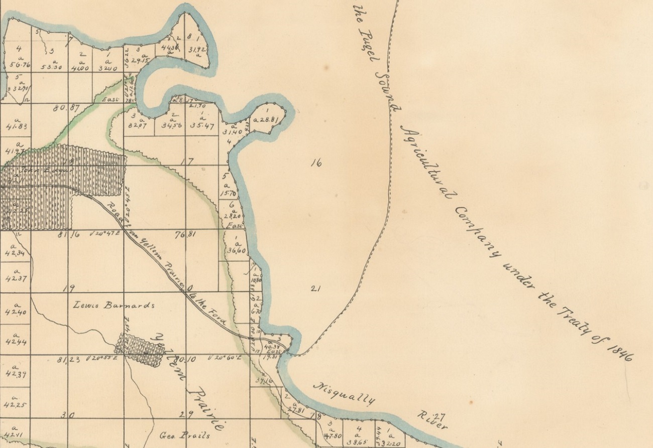
1856 map of the Upper Crossing. 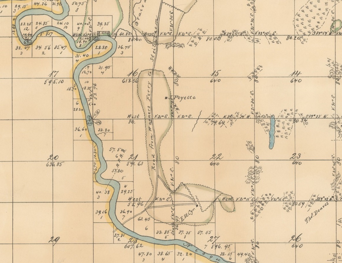
1871 map of the Upper Crossing 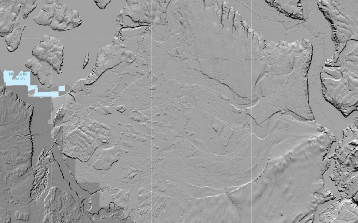
Lidar image of the Steilacoom Plains. 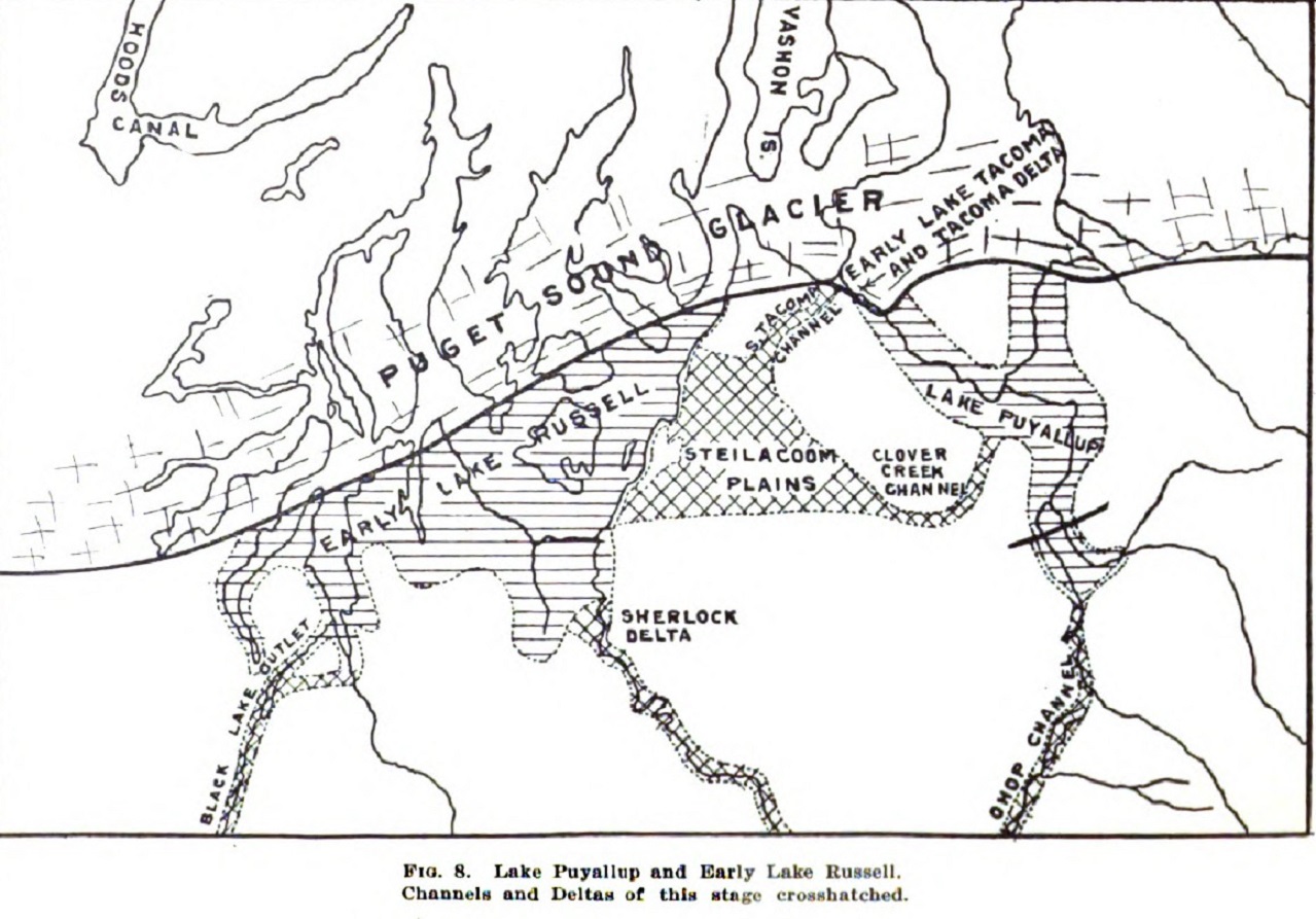
Steilacoom Plains during the Ice Age. |
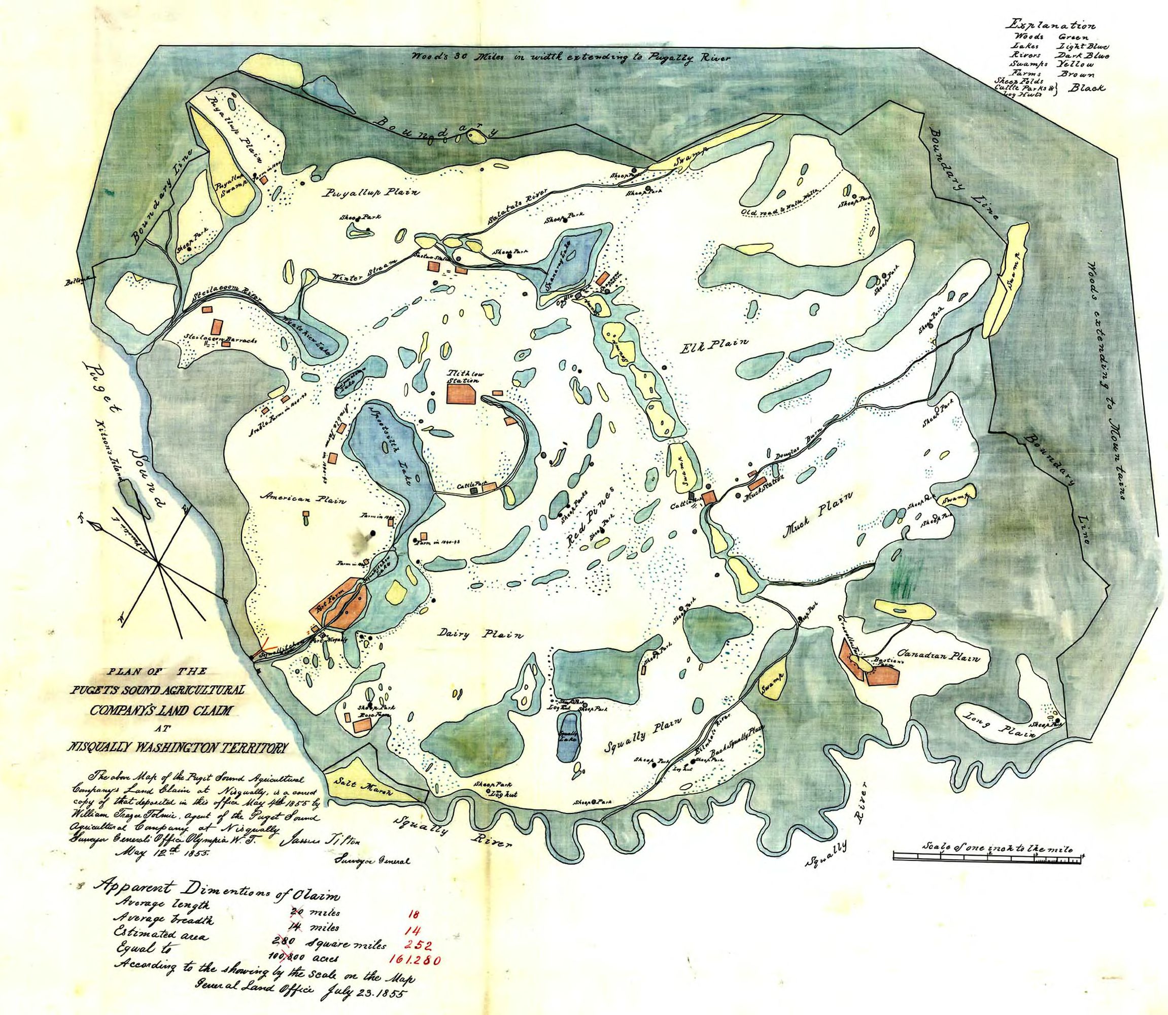
1855 map of the Puget Sound Agricultural Co. 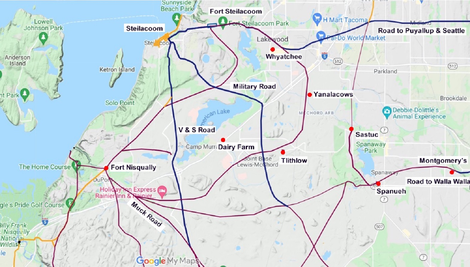
Map of the northwestern portion of the Steilacoom Plains. 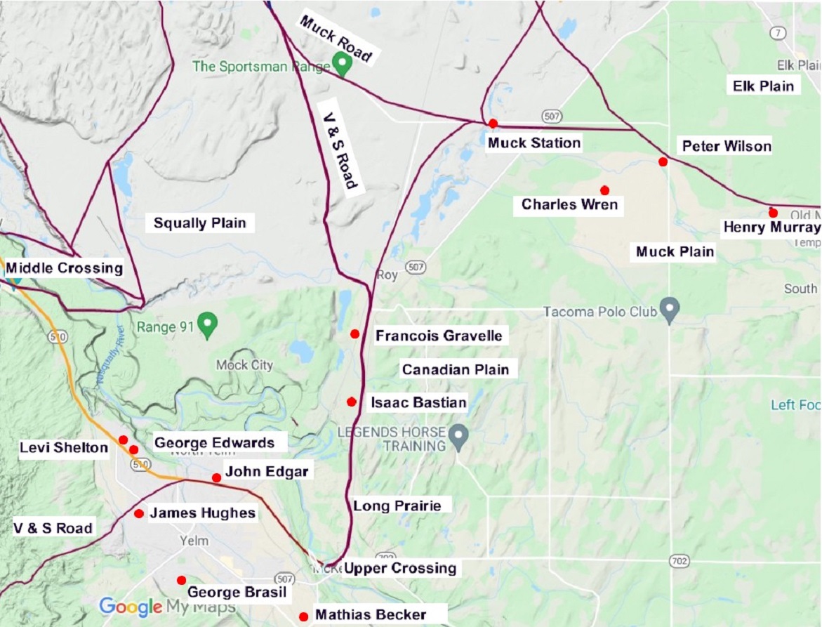
Map of the southern portion of the Steilacoom Plains. 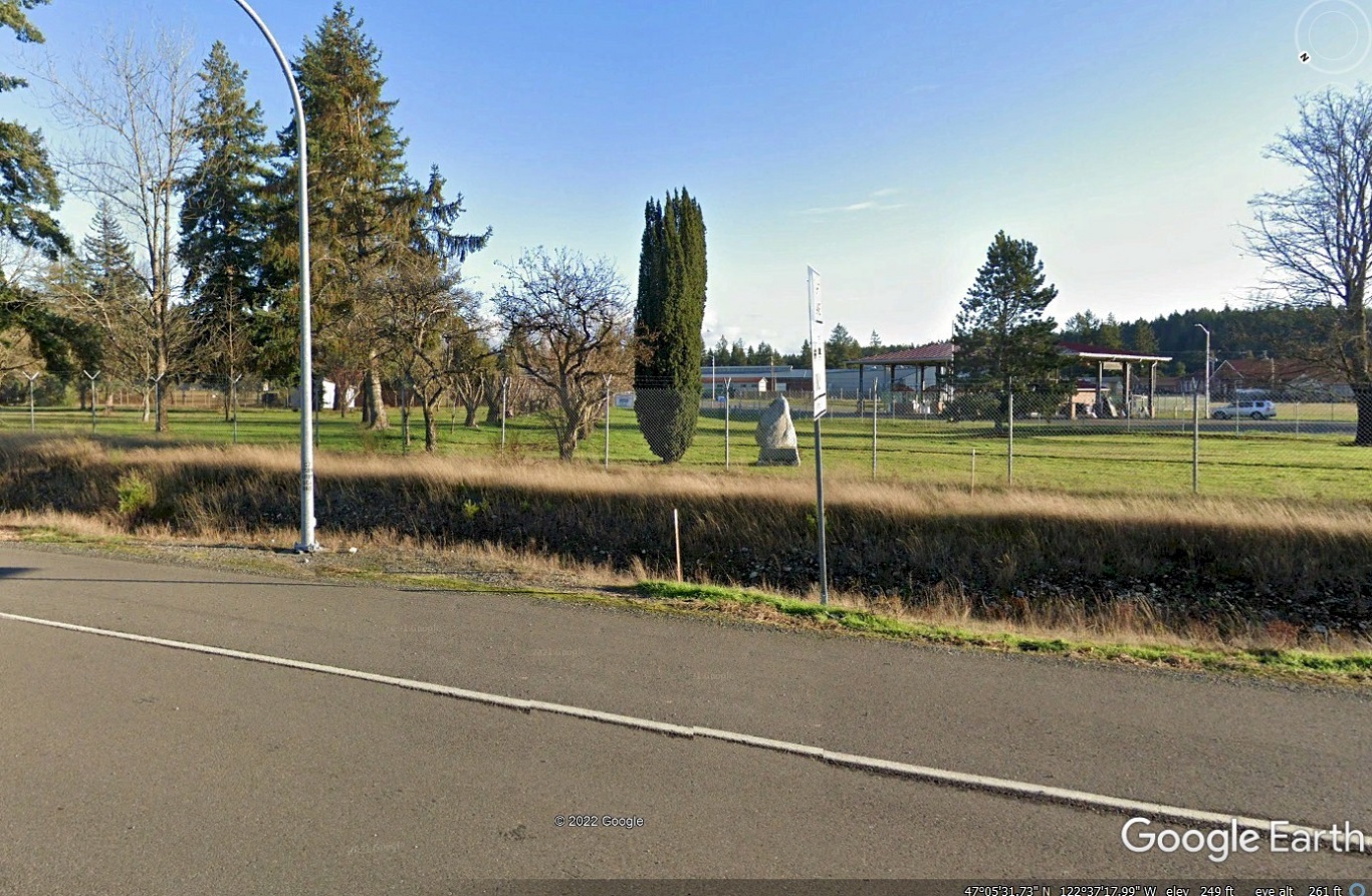
Google Earth photo near the entrance to the Army base showing Muck Road (center left) and the stone marker (center right). |