![]()
The Historic Pacific Highway
in Washington
Mound Prairie / Grand Mound
![]()
The Historic Pacific Highway
in Washington
Mound Prairie / Grand Mound
History of Grand Mound
By Curt Cunningham
Grand Mound Prairie
Before the arrival of the farmer, the plains of Western Washington were covered with large fir and cedar forests. The open places known as prairies, were created a long time ago by the Upper Chehalis, the Cowlitz, and the Nisqually people who burnt the forests to open up areas of land. This was done to create places for their horses to graze, to hunt wild game and to gather camas bulbs. Camas bulbs were a major source of carbohydrates and protein. The prairies would become covered with wildflowers and luxuriant grasses.
The Grand Mound prairie is Upper Chehalis territory and a long time ago there was a large settlement there called "Aqaygt." This name translates to "long open space." The prairie is called nsq'wanxtn, which means "place to dry hides on a frame."
Grand Mound was first called Prairie de Butte by the Hudson's Bay people in the early 1800's, and later in the 1850's, it was known as the Mound prairie by the early American settlers. The prairie is located 15 miles south of Olympia, 5 miles north of Centralia and 8 miles west of Tenino. The Mound prairie is the largest tract of agricultural land in Thurston County at about 8 miles long and 4 miles wide.
A plain is an area of flat land that is treeless. A prairie is a specific type of plain, which is covered with grass. All prairies are plains, though all plains are not always considered prairies. In the Puget Sound region they are called prairies. In the Vancouver area, they are called plains. The Hudson's Bay Co. properly called them plains instead of prairies. Today, most of these plains or prairies are now covered with shopping malls, golf courses and residential homes.
In the book Glaciation of the Puget Sound Region by J. Harlen Bretz printed in 1913 said that; "The Vashon drift of Puget Sound may be divided into two different areas, the northern portion being predominantly ground moraine and the southern part being characterized by outwash plains. These plains are largely prairies, because of the coarseness and sterility of the soil. The latitude of Tacoma affords a convenient division line between these two areas."
The prairie has a peculiar geological phenomenon called the Mima Mounds. These mounds are on average; 8 feet tall and 30 feet wide, and are as close together as potato hills in a field. There are thousands of them spread out across the prairie. There are many theories of how the mounds were created, and the most plausible explanation is that the mounds were created by the melting glaciers at the end of the Ice Age.
In 1841, U. S. Naval Explorer Lt. Charles Wilkes took an excursion to the Mima Mounds to see what was inside of them. He didn't find anything significant in them and from his account of the trip, seemed a bit bummed that nothing was found. You can read about his journey to the mounds at the link on the side bar.
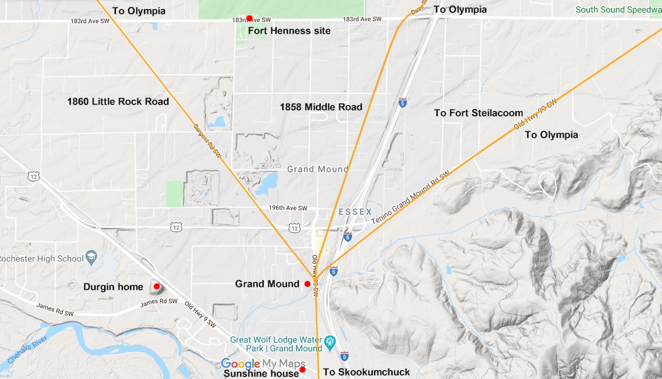
The largest of these mounds is called the "Grand Mound." The Grand Mound is located at the fork of Old Highway 9 and James Road. The Grand Mound is about 60 feet high and 500 feet in diameter at the top. From the top of the mound, you get a magnificent view of Mt. Rainier, Mt. St. Helens, and the tortuous course of the Chehalis river that could be traced by the tall trees along the margin all the way to the ocean. The mound was once a large island during the melting of the glaciers.
Beginning in the 1820's, the Hudson's Bay Company used the Indian trail that ran between Fort Vancouver and Puget Sound. This trail ran through Grand Mound and became a crude ox cart road in 1849, when the Puget Sound Agricultural Company improved the trail between Fort Nisqually and the Cowlitz Farms. Road making through the prairies was easy work and they served as fuel stations for the company's pack animals that traveled the road. The Pacific Highway would follow this route 63 years later.
In 1851, the first settler to make a home at Grand Mound was Samuel James. James came to America from Cornwall, England in the late 1840's, and traveled across the country on the Oregon Trail. In 1853, James built a large 6 bedroom home with lumber that he brought in from Armstrong's mill that was on the Chehalis river about 8 miles downstream. During the 1850's, as more and more people began to travel north from Vancouver to the Puget Sound on the Cowlitz Trail, Grand Mound became a rest stop along the way.
James took advantage of this continuous traffic and grew vegetables that he would sell to hungry settlers, soldiers and transients who were traveling between Puget Sound and the Cowlitz Landing. He had said that never a day had gone by without a somebody showing up at his door.
In 1856, James, who is known as the "Father of Grays Harbor," joined a survey expedition that took a trip down the Chehalis river to the ocean. This was just after the War of 1855 had ended and though the war was over, it was still dangerous for travelers. When the survey party departed Grays harbor on their trek homeward, they had to run for their lives through what is now the city of Aberdeen and they were not able to make camp until the cover of darkness came.
The trouble began when the party was preparing to make their way back to Grand Mound, and they were informed that a much loved wife of a Lower Chehalis chief had passed away unexpectantly. The Chehalis blamed the survey party for the death and a war council was held. They decided to surrounded the group while they were asleep and massacre them. Just before they were about to strike, James was awakened by noise and found a Chehalis Warrior looking down at him. The others quickly woke up and it took a great deal of Chinook Jargon to calm the situation. The survey party was able to talk their way out of certain death and the intruders went away with out doing them any harm.
After the expedition was completed, James and his brother took land claims near Grass creek at the entrance to the harbor and they lived there for the next 10 years. James had said that Damon's point, was then known as Allegoost point and also Peterson's point. On the right side of the harbor was Chehalis point or Hanson's point. The big rock in the harbor called James rock was originally called "Thlemape" by the Lower Chehalis. Back then, the area at the top pf the rock had almost an acre or more of land and was 93 feet high, and on the top was a big fir tree.
In 1852, Leonard. D. Durgin, Josephus Axtell, Jotham Weeks Goodell and E. N. Sargent arrived at Grand Mound. The next year, James Biles and C. B. Baker arrived fresh off the Naches Trail, and took claims on the Mound prairie. Durgin built his frame house on the summit of the Grand Mound where he began to grow vegetables.
On January 21, 1854, the Grand Mound post office and general store was established by Durgin. Mail came in by a stage coach company that was operated by Antonio B. Rabbeson and Judge Benjamin Franklin Yantis. They had built a hotel and stage station about a mile northeast of Durgin near an oak grove. Grand Mound was now a stage stop on the Cowlitz Trail.
The Mound prairie was quickly filling up with industrious and enterprising settlers. That year at least 20 new claims were made and the new residents were busy improving their land. During December of 1854, William. B. Goodell established stage line, which ran between Olympia and the Cowlitz Landing. Between Grand Mound and Olympia, the company built a new wagon road for their coaches. This road was called the "Middle Road" by the locals. Today it is known as Case Road.
The Goodell stage departed Olympia on Tuesdays and Fridays of each week. At the Cowlitz Landing, the stage made connections with the canoes and later the steamers. The rates were; from Olympia to Grand Mound, $3.50, and $10 from Olympia to the Cowlitz Landing. In addition to the stage coaches, travelers could rent horses for travel between Olympia and the Cowlitz Landing and there was a stable at Grand Mound to swap out your horse for a fresh one.
On July 4, 1855, residents from around the area convened at the Grand Mound Hotel for the 80th anniversary of the Declaration of Independence. James Biles was the marshal of the day as the participants paraded to the grove, where arrangements had been made for public speaking. The Rev. Charles Biles gave the prayer and provided the music, J. W. Goodell gave the oration and then gave a toast; "Grand Mound prairie, the heart of Washington Territory, which is the heart of the United States, which is the heart of the world."
Many other attendees gave toasts and afterwards a procession was formed and the company marched to the tables that were spread out under a canopy of majestic firs, and covered with an abundance of the good things in life. About 150 people sat down to enjoy the feast which was provided by the residents of town. After the meal, the guests were entertained by music till late in the afternoon and many did not make it back to their homes until the next day.
During the War of 1855, Fort Henness was erected. The fort was named after Captain Ben Henness, and was located across the street from the Grand Mound Cemetery on 183rd Ave. SW. The fort was built on a rise of ground and was occupied for about 16 months by over 200 men, women and children, including the families of Leonard Durgin, J. W. Goodell and Joseph Axtell.
While the settlers were held up in the fort, they built a small building for a church and school. The upper floor was accessed by an outside stairway and used as a Masonic hall and was the 4th lodge organized in the state, and was instituted as a military lodge. The marker that rests on the spot today, was patterned after the Washington Monument, and sealed inside the marker is a history of the lodge along with some Masonic souvenirs.
A few years after the war, the school building was moved next to the highway at Scatter creek where it continued to be used as a schoolhouse. The building was then later moved to Grand Mound to be used as a schoolhouse. A few years after the move to Grand Mound, this nomadic structure was again moved a few blocks west, and was converted into a church. The last move of the building was when the Sunshine Club of Grand Mound purchased the structure and had it moved to it's present location on Grand Mound Way just west of the Pacific Highway. The building had been enlarged, although the rear portion is still in it's original condition. In 1988, the building was placed on the Thurston County Heritage Register.
In 1856, a pair of nurseries were established at Grand Mound. One was opened by Durgin, and the other by Gangloff & Moxlie. Both nurseries had many varieties of apple trees and various kinds of pear, peach, plum, cherry, currant, gooseberry, along with many types of flowers and berries.
On May 14, 1858, the Postmaster General awarded a mail contract to C. Wallace and Rice Tilley, and they carried the mail between Rainier, Oregon and Steilacoom. Between Oak Point and Grand Mound the mail was carried by Conrad Snyder. From the Cowlitz Landing to Boisfort, was Henry Winsor, and from Olympia to Fort Montgomery (east of Spanaway), was John Shelton.
In 1863, the Grand Mound post office closed, although it was reopened again later that year. In 1870 the mail was brought up form the Columbia river on the Military Road, and Grand Mound became the 3rd mail stop from Olympia and the 6th from Monticello on a tri-weekly service. The Grand Mound post office closed again in 1874 and reopened in 1879, and closed again in 1883, and then reopened in 1884. In 1884, instead of the stages bringing in the mail, the Northern Pacific railroad brought it in on a short line that ran between Gate and Centralia.
The train was known to the locals as the "Galloping Goose" and service lasted until 1942. Afterwards the mail was then brought in by auto until the post office was shut down forever on June 30, 1955. For over a century, the Grand Mound post office was nothing more than a walled off cubby-hole in the general store. The three closings of the post office during the 101 years of its existence showed how unstable the population was.
When the 14th amendment to the Federal Constitution was adopted on July 28, 1868, the question of who were citizens of the United States was raised. Olympia resident Mary Olney Brown, offered her vote at the polls in Olympia. Her vote was refused and when Brown quoted the 14th amendment, she was falsely told that the laws of Congress did not extend over Washington Territory.
The following year, Brown offered her ballot in Olympia and again was refused. At the Grand Mound precinct, Mary Brown's sister, Charlotte O. French, and several other women, were permitted to vote. Other precinct election officers in other parts of the territory interpreted the law in the same manner as the Grand Mound officials and permitted women to vote. Equal suffrage sentiment now began to crystallize in Washington Territory.
In 1871 Susan B. Anthony and Portland activist Abigail Scott Duniway, opened a campaign to organize the women voters in the Washington Territory. Together they traveled up the Military Road from Vancouver to Olympia and visited the settlements along the route. They held meetings and delivered addresses. On October 28, 1871, at a convention held in Olympia, they formed the first woman suffrage organization in the territory. Anthony, upon an invitation from the Legislature, addressed that body on October 20th.
The best efforts of Anthony and Duniway failed to convince the lawmakers. This did not deter them and the association continued its work until 1883, when women's right to vote became a law of the territory. To commemorate the successful attempt by the women of Grand Mound to vote in Washington territorial elections, a historical marker was placed on 198th Ave.
After the railroad was completed between Tacoma and Kalama in 1874, traffic through Grand Mound began to fade. The stages stopped running and the hotel soon closed down. By 1890 there were only 234 people living in the area. The population would stay pretty much the same for the next 50 years.