![]()
The Historic Pacific Highway
in Washington
Toutle River Crossing
![]()
The Historic Pacific Highway
in Washington
Toutle River Crossing
History of the Toutle River
Crossing
By Curt Cunningham
The Toutle River
The north and south fork of the Toutle river begin on the northwest side of Mount St. Helens and flow in a northwest direction for about 23 miles where they converge at the town of Toutle. From the town, the river continues a northwesterly course for about 4 more miles before it turns southwest for about 8 miles and empties into the Cowlitz river about 3 miles north of Castle Rock. After the eruption of Mt. St. Helens in May of 1980, the lahars sent a tremendous amount of mud, ash and debris into the river destroying everything in it's path for miles downstream. Today, 40 years later the ash is still lining the banks of the river.
On September 29, 1889 a party of hikers were descending Mt. Ibex when one of the party sat down and wrote the following; "Looking to the east stands old St. Helens towering high above its neighbors like some giant king with its white crest like some imperial crown, while at its base stretches a broad plateau extending as far around the base as the eye can see, while looking still farther to the east and to the north of St. Helens, the white crest of Mt. Adams peeps over the lower hills as if afraid to show itself, while the intervening distance is one vast unbroken forest of evergreens with the Toutle river winding its way down from the very summit of old St. Helens to our very feet like some giant serpent. Looking down we could see the Toutle 2,000 feet below us, almost a perpendicular descent. Having become weary of the scenery we made our tollsome descent to camp arriving tired and hungry."
The Forks of the Cowlitz
Before the 1860's, the only way to reach Puget Sound from Portland without boarding a ship and sailing up the coast, was to take a canoe up the Cowlitz river to the landing that was located just south of Toledo. This was usually a 2 or 3 day trip depending on the weather and condition of the river. The mouth of the Toutle river was once known as the "Forks of the Cowlitz" and was usually reached on the first or second day if everything went well. It was 19 miles upstream from the mouth of the Cowlitz and was a popular resting place first used by the Cowlitz people as they were traveling between the Cowlitz Landing and the Columbia river.
During the 1830's until the 1850's, the Hudson's Bay Company had rested at the forks of the Cowlitz while going between Fort Vancouver and the Cowlitz Landing. Between 1840 and 1845, wheat grown on the Cowlitz prairie was transported in canoes down the river to their loading facility at the mouth of the Cowlitz river. The larger bateaux were around 30 feet long and were manned by 8 to 10 Cowlitz canoemen. The Cowlitz people were the operators of the canoes that brought everyone and everything up and down the river until the 1860's when the steamers began to ply the river.
On September 6, 1852 Edward Warbass and Alfred Townsend opened a store at Monticello and another at the Cowlitz Landing. On December 10, 1852 Warbass & Townsend as their company was known, began running canoes and the larger bateaux between Monticello and the Landing.
On September 11, 1852 Fred A. Clarke opened the Cowlitz Hotel at the Cowlitz Landing. He also rented horses for people traveling between the Landing and Olympia. On July 2, 1853, Fred Clarke established the Cowlitz Navigation Co. The canoe disembarked the Landing every Thursday morning at 7am bound for Rainier, Oregon. The canoe disembarked Rainier every Tuesday morning a 6am. In addition to passengers and cargo, they also carried the mail. This is when rest stop at the forks of the Cowlitz became known as "Clarke's Landing."
Hard Bread's Hotel
On July 29, 1852, James Gardiner, arrived at the forks of the Cowlitz. He took over an abandoned farm located there along with his 2 sons, William A. Gardiner and James Alexander Gardiner. Not long after, Gardiner converted the log cabin into a crude public house that served the throngs of emigrants that were now coming up the river.
The only food that the hotel offered was boiled salmon, potatoes and blackstrap molasses, which was served with crackers that were so hard, they could kill a man if shot from a rifle. The hotel became notorious for the hard bread and was known as "Hard Bread's Hotel," and they called Gardiner "Old Hard Bread." There were rumors being told in Portland that an old bachelor ran a hotel that was a rough and rowdy place. Gardiner was a widower, and the establishment he ran was known as a bachelor's hall. This may have been the reason for the rumors.
The stories that were told in Portland would horrify the newly arrived women settlers and many families traveling up the river would avoid the place like the plague. (As with all rumors, most of the tales were exaggerated or downright false.)
In February of 1854, Reverend George F. Whitworth, one of the organizers in the establishment of the First Presbyterian Church in Portland, spoke about his night at Jackson's Inn and Hard Bread's Hotel while on a trip to Olympia; "Late in February I departed for Puget Sound, going from here to Monticello by steamboat. Three days by canoe brought me and my Indian companion to Cowlitz Landing, the head of canoe navigation on the Cowlitz river."
"The first night's stop on the trip up the river was made at "Jackson's," where the travelers slept in a bed that was built to accommodate as many as 15 persons, being as wide as the room in which it was built, the sleepers lying across the shelf-like bunk that served as a bed. The second night's stop was made at Hard Bread's Hotel, a settler whose name was Gardiner, but who was better known as 'Mr. Hardbread,' furnishing the conveniences his hostelry afforded."
"Mr. Hardbread received his name from the fact that he was never known to have bread other than sea biscuit to offer his guests. Salmon, black-strap and potatoes were the other delicacies afforded by Mr. Hardbread's table. With a small valise in one hand and my Bible in the other, I walked 45 miles through broken country to Olympia, where I arrived none the worse for the trip."
In the book, Pioneer Reminiscences of Puget Sound, written in 1905 by Ezra Meeker. He tells about his journey up the Cowlitz river and arriving at Hard Bread's Hotel with his family in 1853; "The wife, baby, bedding, ox yoke, and log chain, were sent up the Cowlitz in a canoe, while my oxen Buck and Dandy, and I renewed our acquaintance by taking to the trail where we had our parting bivouac."
"We had camped together many a night on the plains, and slept together literally, not figuratively. I used to crowd up close under Buck's back while napping on watch, for the double purpose of warmth and signal—warmth while at rest, signal if the ox moved. On this occasion I was illy prepared for a cool night camp, having neither blanket, nor coat, as I had expected to reach "Hard Bread's" Hotel, where the people in the canoe would stop over night."
"But I could not make it and so again laid on the trail to renew the journey bright and early the next morning. Hard Bread's is an odd name for a hotel, you will say; so it is, but the name grew out of the fact that Gardiner, the old widower that kept "bachelor's hall" at the mouth of Toutle River, fed his customers on hard tack three times a day, if perchance any one was unfortunate enough to be compelled to take three meals at his place."
"I found the little wife had not fared any better than I had on the trail, and in fact, not so well, for the floor of the cabin was a good deal harder than the sand spit where I had passed the night, with plenty of pure, fresh air, while she, in a closed cabin, in the same room with many others, could neither boast of fresh air, nor freedom from creeping things that make life miserable. With her shoes for a pillow, a shawl for covering, small wonder the report came "I did not sleep a wink, last night."
"Judge Olney and wife were passengers in the same canoe and guests at the same house with the wife, as also Frank Clark, who afterwards played a prominent part at the bar, and in the political affairs of Pierce County in particular, and incidentally of the whole Territory. We soon arrived at the Cowlitz landing, and at the end of the canoe journey, so, striking the tent that had served us so well on the plains, and with a cheerful camp fire blazing for cooking, speedily forgot the experience of the trail, the cramped passage in the canoe, the hard bread, dirt and all, while enjoying the savory meal, the like of which only the expert hands of the ladies of the plains could prepare."
"But now we had fifty miles of land to travel before us, and over such a road! Words cannot describe that road, and so I will not try. One must have traveled it to fully comprehend what it meant. However, we had one consolation, and that was, it would be worse in winter than at that time. We had no wagon. Our wagon had been left at the Dalles, and we never saw nor heard of it again. Our cows were gone, given for provender to save the lives of the oxen during the deep December snow, and so when we took account of stock, we had Buck and Dandy, the baby, and a tent, an ox yoke and chain, enough clothing and bedding to keep us comfortable, with but very little food and no money, that had all been expended on the canoe passage."
On September 29, 1856, Gardiner sold his half his property to William Pumphrey and the other half to his son William, who continued to run the hotel for a few more years. James Gardiner, aka "Old Hard Bread" would pass away in 1858. The hotel most likely closed down when the Military Road was completed and the steamers began to ply the river in the 1860's. By the mid 1860's, more settlers had arrived in the area and established farms and the little cluster of residents became known as the Gardiner Settlement.
In 1858, Pumphrey sold half of his land to Thomas Jefferson Carter. Gardiner's property was also sold around that time and a few years later it was resold for the back taxes. In 1890, William Pumphrey bought the other half of Gardiner's property at a sheriff's sale. Pumphrey's property was located on the north side of the mouth of the Toutle River.
In 1859, a ferry was operating across the Cowlitz river just above the mouth of the Toutle river. It is unknown how long this ferry operated.
On July 20, 1869, Charles Bishop bought 43 acres near the mouth of the Toutle river. On September 20, 1869, Wesley B. Gosnell who lived on the Grand Prairie near Drew's Mills in the 1860's, bought 53 acres at the mouth of the Toutle river.
In 1858 Fred Drew had arrived at Port Gamble to look for work. (no relation to George Drew of Drew's prairie) He was hired by the Puget Mill Company and rose the ranks to log agent. Frederick “Fred” Drew was born Aug. 27, 1838 in Boston, the son of Joseph Lawrence Drew and his wife Amelia Smith Drew.
In the 1860's Fred Drew was one of the best at locating land for the timber company. Because of the vague wording in the 1862 Homestead Act, speculators took advantage of the wording to buy up thousands of acres of land. Fred Drew's name would become well known in the Olympia Land Office as his name appears many times in the land records. He purchased land for the lumber company all over the Puget Sound region. On September 20, 1869, Fred Drew purchased 300 acres at the mouth of the river. Drew would continue to purchase thousands of acres of timber land around the Toutle river area well into the 1870's.
The Northern Pacific
In 1871, the Northern Pacific first built it's original mainline over the Toutle river where the Pacific Highway now crosses. In 1908, the railroad realigned the mainline and added double tracks from Vancouver to Tenino. The old bridge at the Toutle river was abandoned and later removed. The new mainline was relocated about a half mile west and it ran right through Pumphrey's old property and where Hard Bread's Hotel used to be.
On February 4, 1871 Captain John F. Kidder and his party had just finished the locating survey for the Northern Pacific line between Kalama and the mouth of the Toutle river. On December 9, 1871, the Kalama Beacon said that the track had been laid and construction trains were running on the line almost 18 miles, extending 5.5 miles beyond Kidder's camp on the Cowlitz river. Opposite Freeport (Kelso) a side track was built for the landing of steamers for the offloading of the materials needed to build the bridge. The bridge over the Toutle river was completed in December of 1871.
Cowlitz City
From the Cowlitz river to Mt. St. Helens is a vast forest of cedar and evergreen trees. Cedar shingles became an early industry on the Toutle river in the late 1880's and the river was used to float down thousands of cedar bolts to the mills at the mouth and on the Cowlitz near Castle Rock. In 1914 a large lumber and shingle mill was constructed and a company town was platted. This town was called Cowlitz City and was located on the north side of the mouth of the Toutle river in the Gardiner settlement of the 1860's.
Printed in the Oregon Daily Journal on March 28, 1914; "the name of the new town located about two miles up the Cowlitz river from Castle Rock is Cowlitz City. The townsite has been surveyed and subdivided into lots. In addition to the 65,000 capacity mill that is under construction, the promoters of the new town, who are from Portland, say that, after the plant is in operation, they will install a shingle mill of large capacity. The Northern Pacific railway will make Cowlitz City a regular freight and passenger station the town being on its right of way. Lumber was being sent upriver to build homes for the workers."
On April 17 1914, the Cowlitz City Townsite Company was capitalized with $5,000 and was incorporated by G. C. Harbolt, R. R. Coster and S. F. Wilson. The town was most likely abandoned after the mills closed. Today there is nothing remaining of the town or mill and is now a small cluster of farms along with some RV parks.
The Pacific Highway
After the railroad had relocated to the west, there was about 2 miles of abandoned right-of-way north of the Toutle river. The old wagon road was on the north side of the old right-of-way and was so bad that cars started to turn off the old road and travel on the abandoned railroad grade from the Toutle river to the bottom of Gumbo Hill. The wagon bridge over the Toutle river was to the east of the Pacific Highway.
In the summer of 1913, Cowlitz county awarded a contract to the Huber Construction Company to built a steel bridge 184 feet long and 20 feet wide over the Toutle river using the old bridge piers of the Northern Pacific. The railroad gave the county the abandoned piers along with the old right-of-way for the new Pacific Highway.
In 1914, the State Highway Board had given approval for improvement of sections of the Pacific Highway north and south of Castle Rock. The work was never started due to conflicts with the right-of-way. In 1917, prospects of a world war was eminent and the military had given the Pacific Highway increased importance as a road for coast defense maneuvers. On May 1, 1917, the state authorized $248,878 for the improvements and/ or construction to finish the highway between Vancouver and Chehalis.
Nothing was done to the road north of Castle Rock until September 15, 1919, when the 6.67 miles of highway was graded and surfaced with gravel. The work was difficult and required heavy rock removal. The job was completed in January of 1921. On January 2, 1921, road crews were busy clearing slides and ditches and filling washouts on the 6.71 miles of highway north of Castle Rock. This work was completed in July 16, 1921 by day labor.
The Highway is Paved
On May 16, 1923, concrete paving work started on 4.71 miles of the highway north from Castle Rock to Laughlin's at the Toutle river. The Mc Hugh Construction Company from Seattle laid the one course 20 foot wide roadbed. The work was completed on December 4, 1923. On April 16. 1923, paving work started on the 5.53 miles from Laughlin's at the Toutle river to Neal's, which is located where Barnes Drive meets the Jackson Highway at the freeway. Neal's was named for Byron E. Neal an early homesteader. Today there is a truck stop at the interchange known as Gee Cee's Truck Stop. The paving work was completed on December 22, 1923 between Castle Rock and Toledo.
The Mickey Mouse Bridge
In 1936, the old Pacific Highway was undergoing an upgrade to become U.S. Highway 99. The old 2 lane bridge over the Toutle River built in 1913 was too narrow for the new roadway and was removed. In its place, a new wider bridge over the river was built to the west of the old one. This is a riveted 10 panel Pennsylvania through truss bridge 366 feet long and 44 feet wide. I do not know why it is now called the Mickey Mouse Bridge.
In 1953 the new 4-lane US Highway 99 was routed onto the "Toutle Curves" and the old Pacific Highway at the Toutle river. The Mickey Mouse bridge was re-striped for 4-lanes. This was a dangerous place as the old Pacific Highway had to merge onto the new expressway. This arraignment lasted until the twin bridges were built over the Toutle river to the west in 1969.
On May 18, 1980, Mt. St. Helens erupted. The immense volcanic lahars flooded the Toutle river with ash and debris and washed out many of the bridges downstream. The Mickey Mouse bridge along with the interstate bridges survived the devastation that had rumbled down the river.
The sand bar at the Mickey Mouse bridge has been a place where the locals would come to during the hot summer months to take a dip in the river and have a picnic. The sand bar makes an ideal beach and has been used by the locals for over a hundred years.
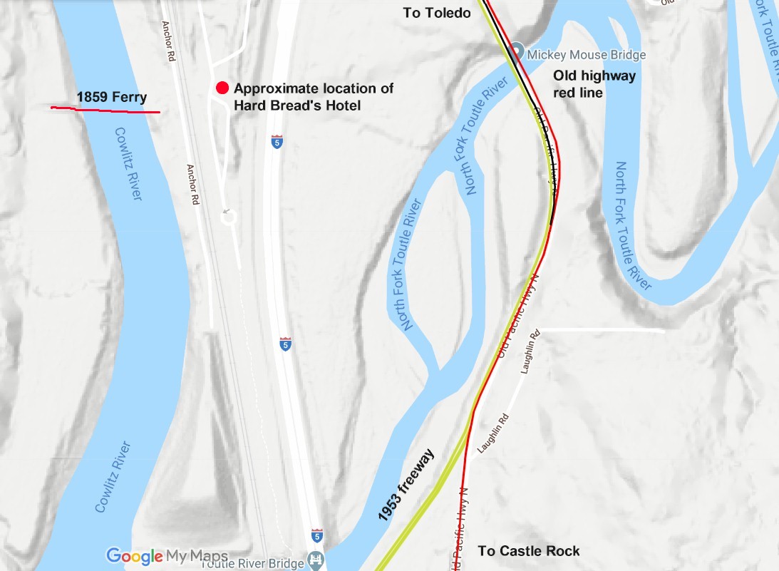
2020 map 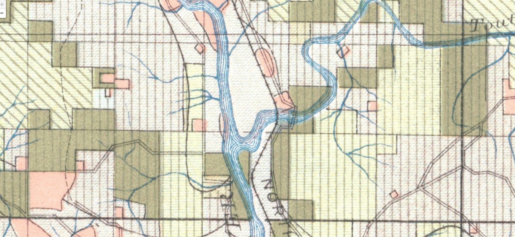
1910 map showing the original mainline of the Northern Pacific. 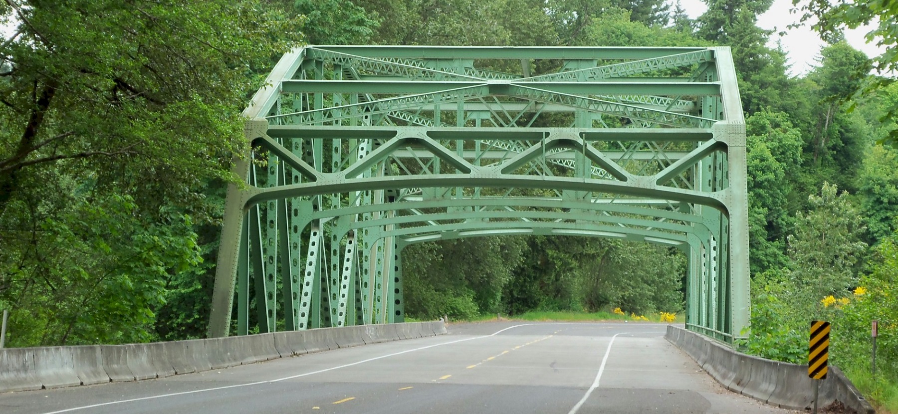
Looking south 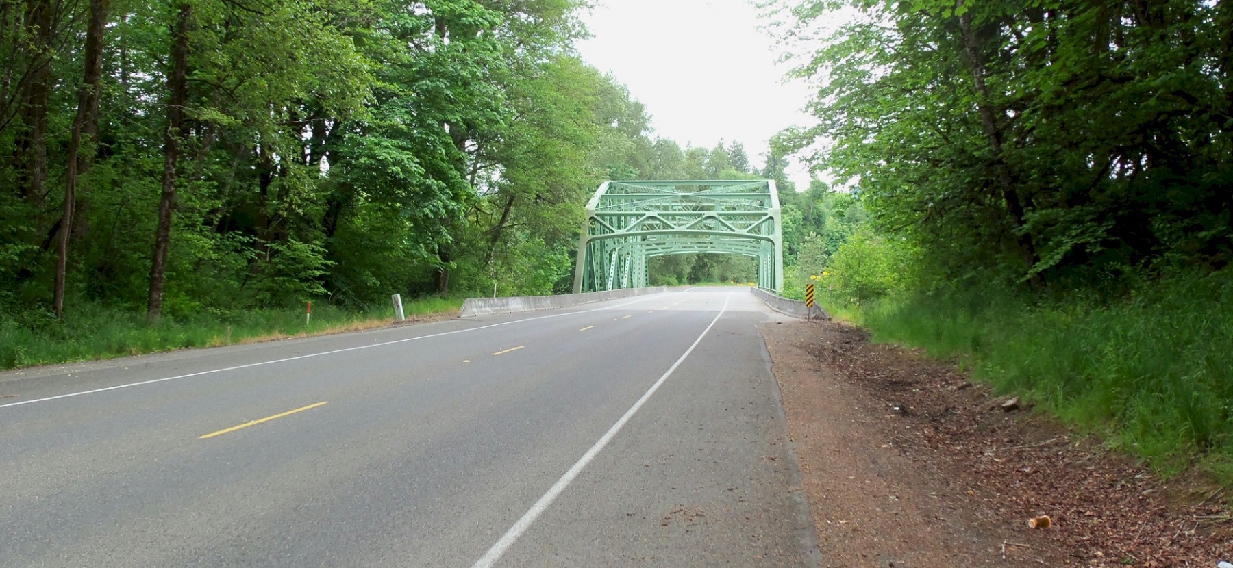
Looking south. The old highway is on the left shoulder in this photo. |
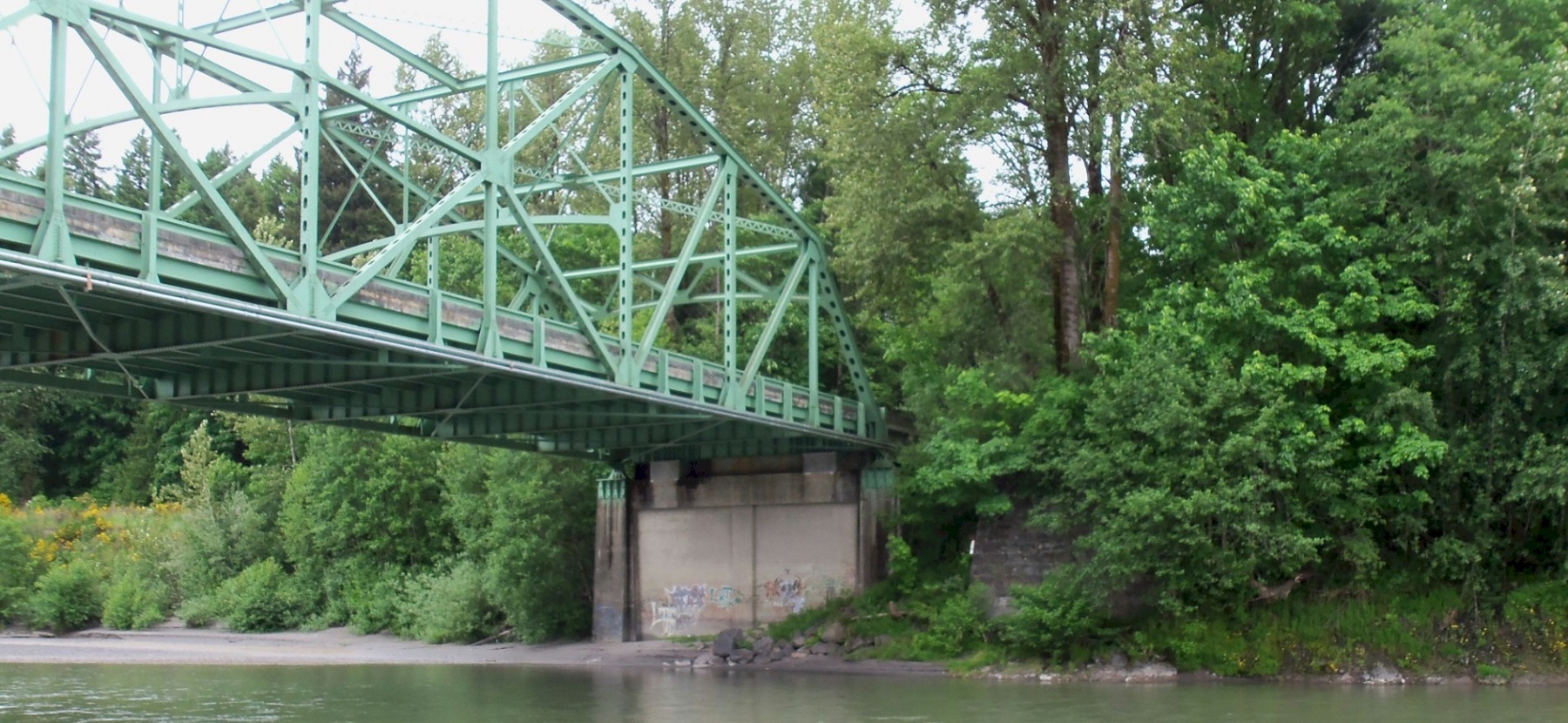
looking NW. You can see the old railroad bridge abutment to the right of the bridge. 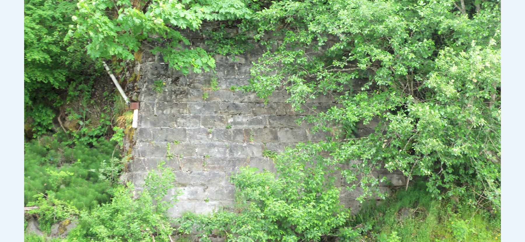
The 1871 railroad bridge and the 1913 Pacific Highway bridge abutment. 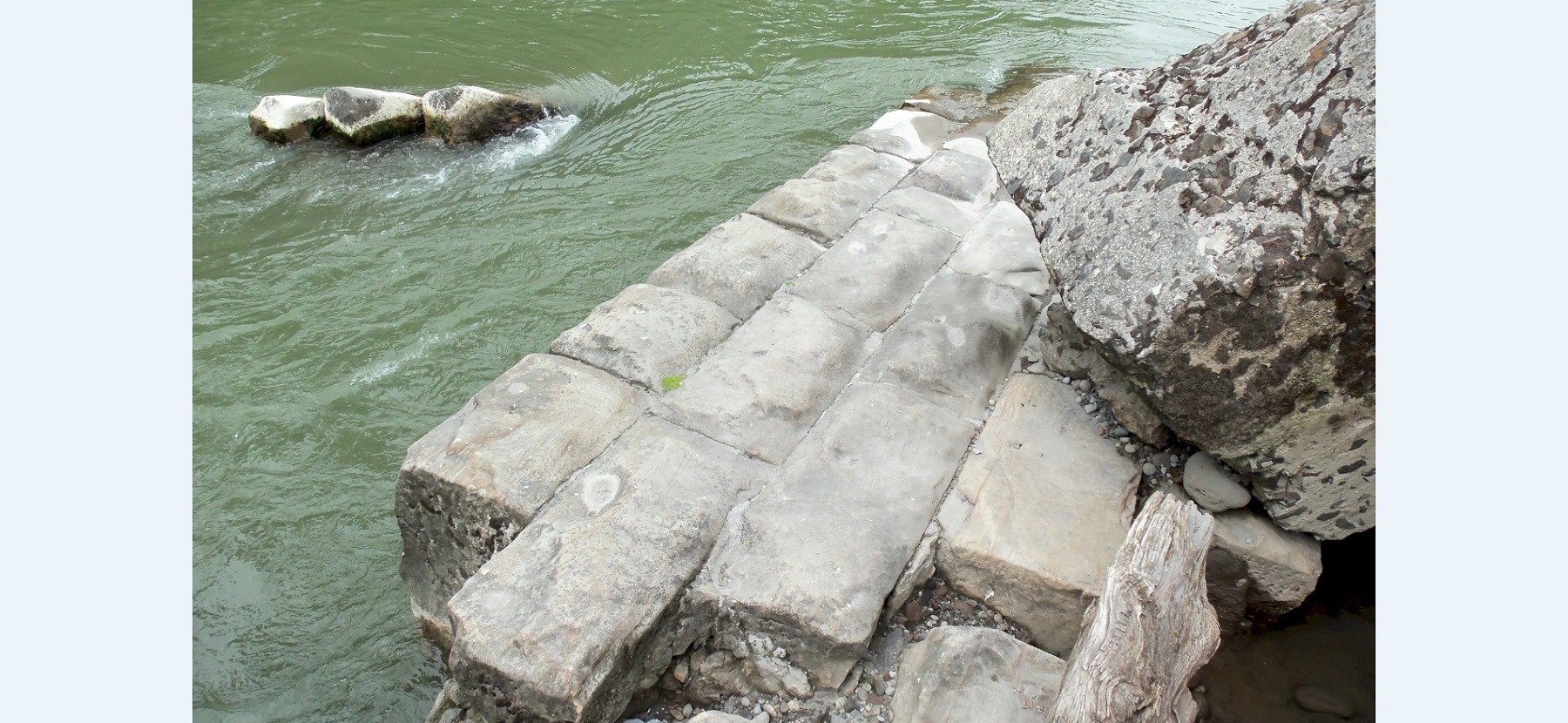
Pieces of the south abutment that was washed out in 1980. 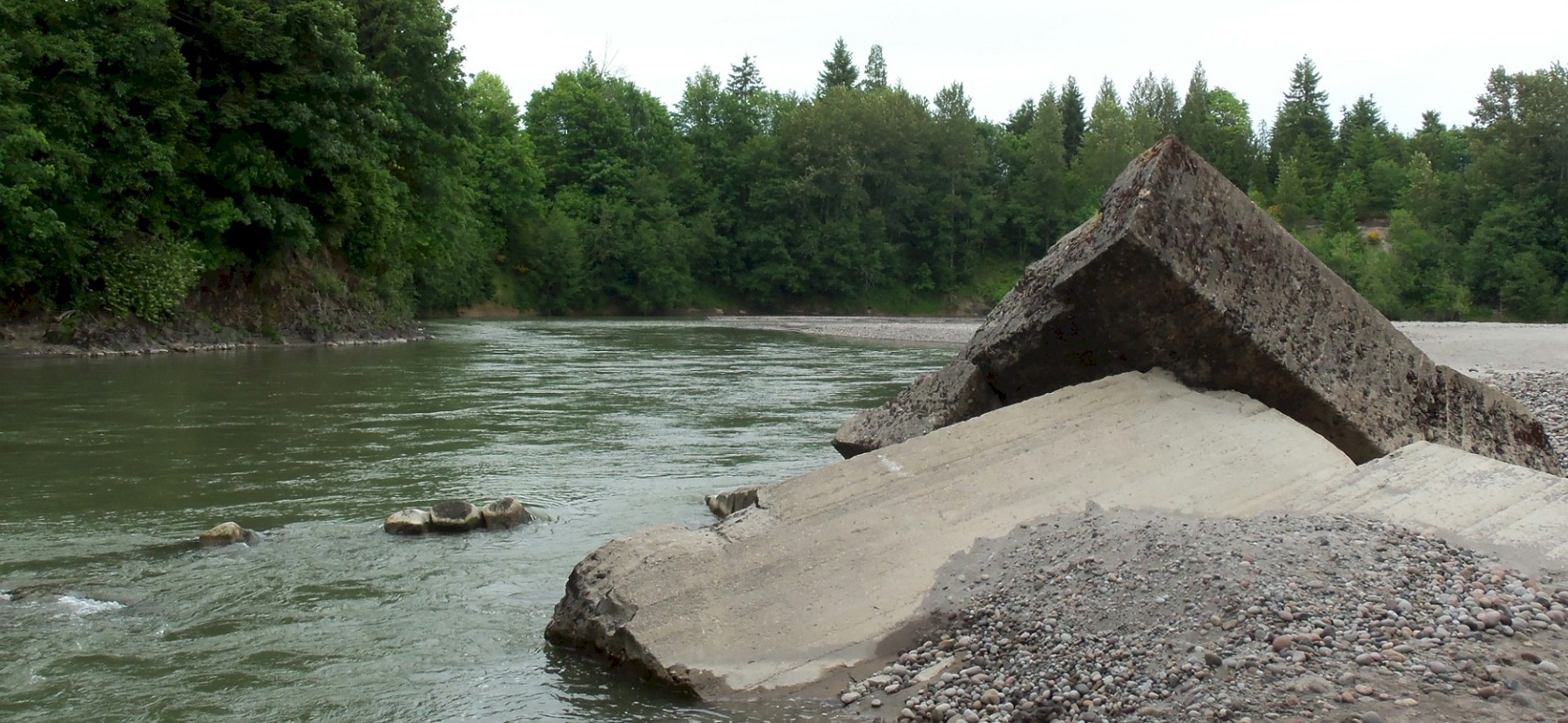
Looking east. |