![]()
The Historic Pacific Highway
in Washington
Kelso
![]()
The Historic Pacific Highway
in Washington
Kelso
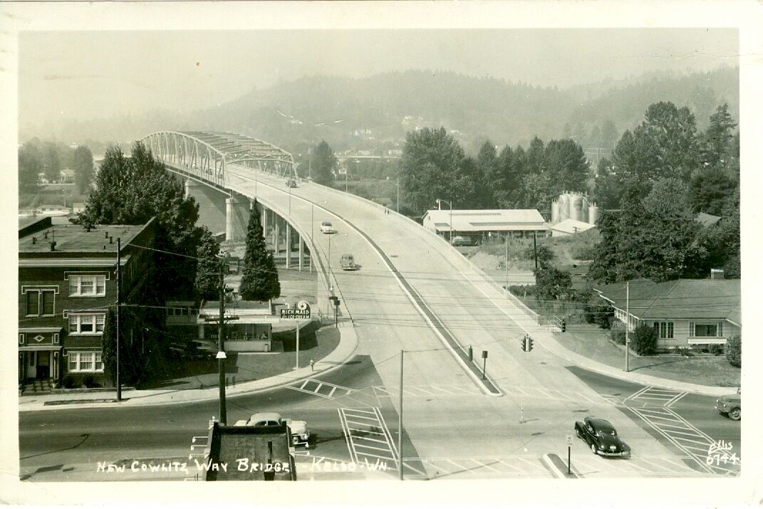
1953 Cowlitz Way bridge
Photo courtesy Washington
Rural Heritage
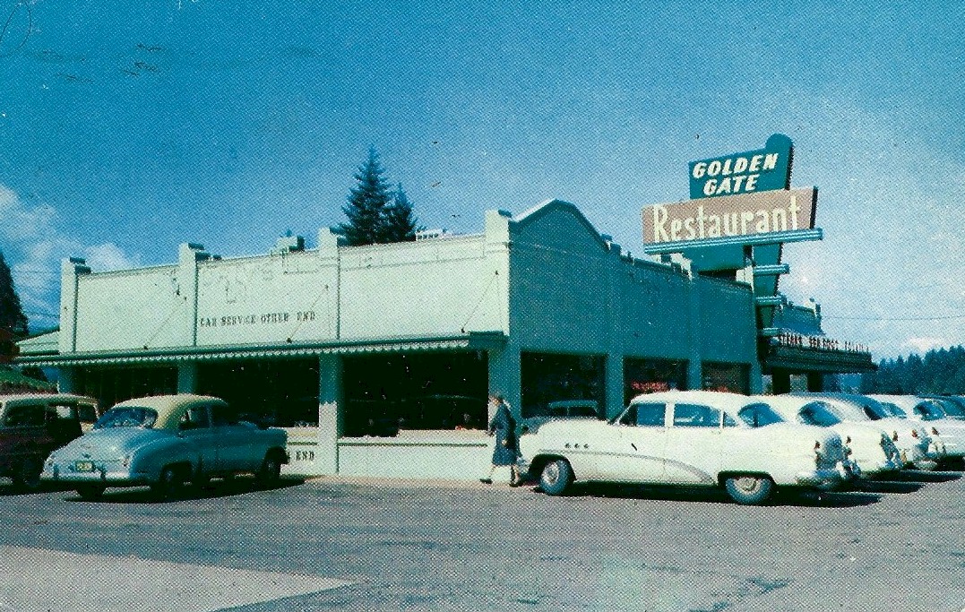
The Golden Gate Restaurant, was located 1 mile north of Kelso along the Pacific Highway during the 1950's and 60's. This building no longer remains.
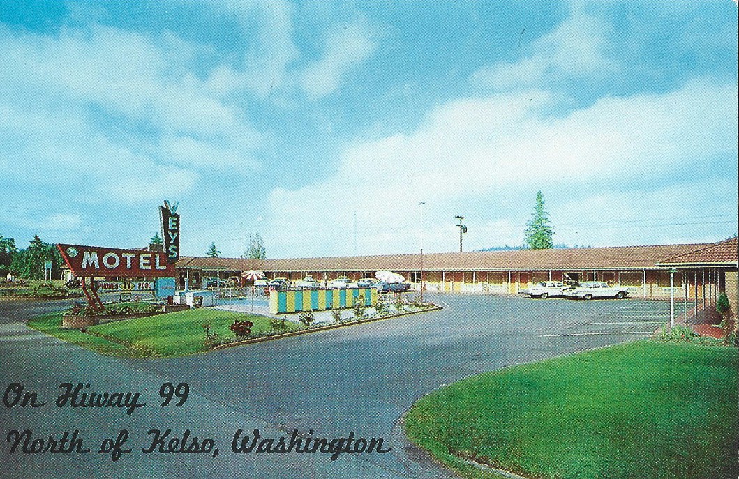
Vey's Motel was located 1 mile north of Kelso on the Pacific Highway during the 1950's and 1960's. The motel had 30 rooms with spacious living which included tile bathrooms and a heated pool. It was next to the Golden Gate Restaurant and a Standard Gas Station. The motel no longer remains.
A History of Kelso, Washington
By Curt Cunningham
The First Inhabitants
The city of Kelso is
located opposite Longview near the mouth of the Cowlitz river 38 miles north of Vancouver. This area is
the ancestral home of the Lower Cowlitz people. The
Cowlitz tribe consists of 2 groups, the Upper and the Lower. They lived in
small villages along the river. One of the most extensive ethnographic and historical descriptions
of the Cowlitz was that of Edward S. Curtis. In The North American
Indian he wrote;
"The Cowlitz comprised about 30 settlements distributed along Cowlitz river from its junction with the
Columbia to a point a few miles east of the Willamette meridian, a distance of forty to fifty miles. Allied
by speech and by proximity, the people of these villages were not politically united by a tribal organization.
Nevertheless their language contained a collective name for them -- Stl'pulimuhkl."
"No early writer gives us an adequate estimate of the Cowlitz population before strange diseases began their ravages. Native information must therefore be relied on. From one of the few survivors was obtained, along with a full list of the villages and their location, a careful estimate of the number of houses in each settlement. The result is surprising, indicating a total of 445 houses, or a minimum population of more than 6,000. It is safe to say that prior to about 1830 there were over 4,000 people living on the Cowlitz river, though it must be said that a few of the villages near its mouth were partly inhabited by Chinookan people married to Cowlitz.
Ethnologist George Gibbs, who made his observations in 1853 and later, said that; "the maximum number of Cowlitz and Upper Chehalis was 4,000, but at the time the Cowlitz were rapidly approaching extinction. The swift depletion of this tribe was due almost wholly to epidemic disease. It is known that between 1820 and 1830 congestive fever worked havoc among the tribes of the lower Columbia. About 1830 measles attacked the Cowlitz with terrible effect, and about 1845 a visitation of cholera resulted in some 200 deaths. Then quickly followed fever and chills, and the fever-racked natives, throwing themselves into the streams for relief, hastened the end."
More than half the people died at this time, declared a woman who survived the attack. Many a house was left empty, or with a single occupant. Then in rapid succession came measles, cholera, fever, and again the measles, and finally a few years later an outbreak of smallpox completed the work and left the Cowlitz little more than a name.
Sir George Simpson, the Governor of the Hudson's Bay Company for North America, wrote in 1841; "When I descended the Cowlitz in 1828, there was a large population along its banks; but since then the intermittent fever, which commenced its ravages in the following year, had left but few to mourn for those that fell. During the whole of our day's course, till we came upon a small camp in the evening, the shores were silent and solitary , the deserted villages forming melancholy monuments of the generation that had passed away.
In the 1850's before any roads were built up the Cowlitz valley, the river was the only way to get to Puget Sound. The Cowlitz people used their canoes to haul all the settlers and their belongings from the mouth of the Cowlitz river to the landing at Toledo. They continued this venture until the steamers took over in the 1860's.
One of the earliest known inhabitants of the Kelso area is said to have been a man of short stature who was named Ko-wee-na. Ko-wee-na, in the Cowlitz language translates to "short man" and this is where the name "Coweeman" comes from. Ko-wee-na is said to have lived near the mouth of the Coweeman river.
The earliest known family to have lived at Kelso was the Wannassay family. They can trace their ancestry to Jack Wannassay, a Lower Cowlitz, who was born between 1820 and 1840, and his wife Sally "Patch-Eye," (Annie White) a Klickitat. Frank Wannassay born in 1873, was the 4th child of Jack and Sally. Frank lived in a houseboat on the Cowlitz river at Kelso until he passed away in 1934.
Between 1878 and 1904, the Upper Cowlitz and Lower Cowlitz not only merged politically as a consequence of Federal policy, but also to some extent socially. This was accomplished under the leadership of important Lower Cowlitz religious leaders such as Iyall Wahawa, whose Indian Shaker faith helped bridge the differences between these bands after 1893. Iyall Wahawa and Lincoln White, (Annie White's brother), also a Lower Cowlitz, ministered to the Upper Cowlitz, as well as to members of their own group.
Throughout the later 19th century and first half of the 20th century, common economic activities for all Cowlitz subgroups, included commercial and subsistence berry picking, commercial hops picking, subsistence fishing, and commercial logging.
The Cowlitz never entered into a treaty with the United States, but the remnant of the tribe was placed in the Puyallup reservation. Today the Cowlitz are scattered throughout the region and about 30 or so families still live near the Cowlitz river. Most of the 1,400 member tribe live within a 2 hour drive.
The First European Settlers
In December of 1847, Peter W. Crawford, arrived at Fort Vancouver. While he was there, he met Edward West and James O. Rayner. West had a small skiff and invited Rayner and Crawford to travel with him down the Columbia in search of a place to stake a claim and start a farm. Crawford told West that when he was on his way across the Oregon Trail, he had met Dr. Marcus Whitman at his mission near Walla Walla, and Whitman told Crawford of a river that flowed into the Columbia where good land could be found.
The party liked the idea and decided they would go and find this river. After traveling down the Columbia they arrived at the mouth of the Cowlitz river. After traveling up the this river a short distance, they came upon a cabin and some other buildings on the west side of the river which belonged to the Hudson's Bay Company. This was their loading facility for grain, beef and produce which was purchased by the Russian-America Company, who had a settlement at Sitka, AK. This loading facility was in operation from 1844 to 1849, and would become the village of Monticello in 1850.
The party stopped at the landing and met a man named Joachim "Tebo" Thibault who was the person in charge. Tebo lived there with his Chinook wife Louisa and their daughter Eunis. After a short visit with Thibault, they continued on their journey. About a mile upstream from the loading facility, they landed on the east side of the river where they met Anton Gobar, another Hudson's Bay employee. Gobar was busy tending the cattle which were kept there before they would be loaded into the holds of the Russian ships by their horns still alive.
Anton Gobar, was the first European to live on the east side of the Cowlitz near today's Kelso. He lived in a cabin which was located on a small prairie, opposite to but a little below the HBC granaries near the mouth of the Coweeman river. This river was once known as Gobar's river. Before the grainery was established HBC employees traveling throught he Cowlitz Corridor would make a stop at the mouth of the Coweeman river.
Gobar was in charge of the cattle station there and in addition to the live beef which was sold to the Russians, he also tended to the animals which were in transit from Vancouver to the Cowlitz Farms and Fort Nisqually. The animals would be driven up the ancient trail which was on the east side of the Cowlitz river.
After the visit with Gobar they looked around and decided they liked the area and proceeded no further up the river. On December 12, 1847, the group traveled back to Oregon City to record their claims. Crawford and West took adjoining land on the east side of the Cowlitz river where they had met Gobar as he was tending to the cattle. On December 25, 1847 they filed their claims in Oregon City.
Crawford was a surveyor, and was asked to survey the the town site for Vancouver in the summer of 1848. After word of the gold discovery in California the following year, Crawford decided to head south to find his fortune. After a few months digging for the yellow metal and not finding "El Dorado," Crawford returned to his claim on the Cowlitz river during October of 1849, and settled down to live out his life on the river for the next 40 years. Peter Crawford would pass away on June 10, 1889.
In 1850, Crawford platted the towns of; Milwaukee, St Helens, Milton, and Monticello. Crawford became the first surveyor for Cowlitz county, and also served as Justice of the Peace, and at one time held the position of United States Deputy Surveyor. In 1883, he was elected surveyor for the city of Vancouver, and in 1884 he was hired as county surveyor of Clark county.
Other early arrivals to the Kelso area in the 1850's were; Victor M. and Isabella K. Wallace, Frederick B. and Nancy Smith, William D. and Cordella C. King and Adam Redpath. Throughout the 1860's, the area gradually filled with settlers who were busy building up their farms.
In 1871, the Northern Pacific began to built its line from Kalama northward and the tracks were laid across Crawford's claim on its way to Tacoma. Crawford also donated a few acres to the railroad, and a small shack was built to serve as a depot. This was the 4th stop on the new line and was known as Cowlitz station.
On January 21, 1881, Portland's Willamette Farmer printed the following; "Mr. P. W. Crawford, who owns a section of land near Cowlitz station proposed to lay off lots for a town upon his premises. The location is good, being accessible by rail and river." Crawford would eventually file the plat for his new town in 1884.
On June 16, 1882, the Columbia river overflowed its banks and flooded the land from the mouth of the Cowlitz all the way to Freeport. The 16 miles of track from Kalama northward was covered in places, but trains could still make it as far as Cowlitz station. Here the steamers had a good landing to take on the stranded railroad passengers and transport them to Castle Rock where they could board another train and continue their journey northward.
On June 13, 1884, J. L. McElhany was operating a store at Cowlitz station. On October 2, 1884, Crawford filed the plat for his new town that he named Kelso after his hometown back in Scotland. A. E. Edlin was first to purchase a lot for $25 and then he established another general store. Crawford also donated land for a church and a courthouse. By 1888, Kelso had about 350 residents and by 1889, the population was 500. Kelso incorporated on January 7, 1889.
A Trip to Kelso
On April 29, 1905 - C. H. Read wrote about his trip to Kelso that was sent to the
editor of The Oregon Sunday
Journal; "By invitation of a prominent business man of Kelso, we visited that, city on Monday,
April 24. We left Portland on the steamer Northwest at 6:45am. It was an ideal
spring day, just cool enough
for a spring overcoat, as we sat on the forward deck enjoying the fine views
constantly opening to our sight as the steamer glided past St. Helens, Kalama and Rainier,
and thence up the Cowlitz river, reaching Kelso at 11am."
"We left the steamer at this point, which proceeded to Toledo, the head of navigation, where it remained all night. We found Kelso a thriving city of 1,200 inhabitants, the principal industry being the cedar shingle mill employing 75 men and boys, with a payroll of $30,000 per month, and turning out 600,000 shingles per day, the shingles being shipped all over the country to Chicago, Boston and Texas."
"The mill is operated by a battery of 10 boilers and engines aggregating 250 horsepower. We were escorted through the mill by the superintendent and witnessed the sawing, edging and packing operations. When the shingles are packed they weigh a little over 200 pounds a bundle, they are then placed in the dry house, where they lose one half their weight. The mill has orders ahead for all the shingles it produces."
"The citizens of Kelso are building a draw bridge to Catlln 900 feet in length and 16 feet in width, costing $15,000, to be finished by July 1st. At Kelso there is a fine opening for a good hotel, the lodging houses not having the capacity for the traveling public. The steamer returns from Toledo to Kelso the following afternoon at 3 o'clock crowded with freight and passengers for Portland."
"We feel greatly indebted to Captain Delude. Purser A. E. Kruse and Chief Engineer William Linn for the many courtesies extended to us, and we cordially recommend visitors to the Lewis and Clark fair to make this one of their side trips in visiting Portland."
The First Bridge to Catlin
Catlin was once a small village opposite Kelso just north of Freeport in the 1880's and 1890's. Over the years as the area grew, Catlin was absorbed into the city of Kelso and is now known as West Kelso.
The first proposal to build a bridge over the Cowlitz river between Catlin and Kelso was on November 25, 1904, at a meeting at the office of U.S. Engineering Corps Major William C. Langfitt. There was about a dozen people who attended the meeting representing the Kelso Bridge company, the citizens of Kelso and Catlin and the various steamboat interests.
There was very little opposition against the proposal though Captain S. V. Short of the Oregon Lumber company wrote; "The proposed draw bridge is not wide enough. It should not be less than 125 feet in the clear, as there is heavy logging business transacted along the river, and the boats must have room enough to work. There is no need for a bridge at Kelso. There ought, instead to be a ferry."
H. E. McKenney, secretary of the Kelso Bridge company, said; "We propose to build a wagon bridge 100 feet in length, with an 80 foot draw, the highest part of the bridge measuring 90 feet from the water. The main span will be 300 feet long, and we will place the draw near the Kelso side, as the channel is there.
On October 20, 1905, the Kelso drawbridge over the Cowlitz river opened for traffic. The bridge was a cable suspension structure with a 100 foot knuckle or "jackknife" draw, built in 2 parts of 50 feet each. Each part was attached to the bridge at either pier with hinges 80 feet above the water. Little power was needed to raise and lower the bridge, requiring only an 8 horsepower motor. The bridge could be opened in a few minutes and its design was new to the west. It was 700 feet long including the approaches, the river being 624 feet wide. It was built for $15,000 using local funding.
The Flood of 1906
On November 15, 1906, the Cowlitz river overflowed it banks and flooded all the towns in its path to the Columbia. The lights went out in Kelso, but the rising river was held in check by the railroad grade. Kelso largely escaped any serious damage, while the town of Castle Rock was submerged. One of the casualties of the flooding was the Kelso bridge, which due to the build up of debris, was washed away at 8am with a loud crash. All the roads were washed out and the only way to get between the towns was to walk on the railroad tracks. The steamers would only go up the river as far as Kelso because they did not know what the flood had done to the navigation of the river upstream.
On December 21, 1906, the Cowlitz river flooded again and this time it reached a high water mark of 19 feet, which was 3 feet less than the flood that hit the previous month. Little damage was done this time except that the old ferry that was put back into use since the bridge was washed away, was torn from its moorings and was carried downstream where it became stranded on an island near the mouth. All riverboat traffic was halted for that week until the river had fallen. The ferry would be pulled off the island and put back into service until the damaged bridge was replaced.
On January 22, 1907, J. A. Fasteband was awarded the contract to replace the damaged Kelso bridge. On May 27, 1907, the 2 masted schooner Abbie of San Francisco, was towed up the Cowlitz by the steamer Nestor, to Ostrander, where she was loaded with lumber from the mills of E. S. Collins. It was the first time an ocean going vessel had come up the river in a long time. The mill planned to send more vessels up the river during high water. Because of this, Collins donated the timbers for the new bridge that were 15 feet higher than the old bridge, so that the sailing ships could pass under it. At ordinary water, the cable over the draw was about 100 feet above the water.
On December 23, 1907, a review of the growth of Kelso was submitted to C. W. Mott the general immigration agent for the Northern Pacific. The statistics included the town of Catlin, that was to be annexed into Kelso, and to show the changes made since January of 1907. During that time, 96 residences were built averaging $1,000. The bridge across the Cowlitz had been rebuilt at a cost of $12,000 replacing the one that was washed away. New buildings included a Presbyterian church, an addition to the school, a lumber mill with a capacity of 15,000 feet daily, 2 brick blocks, 5 frame business houses, a new dock, a machine and tooling shop, a cold storage and ice plant, a National bank, a fruit and vegetable factory, a greenhouse, and a 2 mile sewer system.
After the completion of the second bridge, the tolls had nearly doubled. There was heavy traffic over it and the general feeling of the community since Catlin had become West Kelso, that the county should purchase the bridge and remove the tolls. On July 13, 1908, petitions began to circulate requesting the county commissioners to purchase the toll bridge between East and West Kelso.
Telephones come to Kelso
On June 12, 1909, the Granger Telephone company, a local corporation; using the Home Telephone system, had completed placing 75 new phones in the vicinity of Kelso. The mechanism for the central office was also put in place. The system was powered by an electric motor for charging the batteries and powered from the local electric company that had been set up under the supervision of Paul Graf, of the Stromberg Carlsen Electric company, from Rochester, N. Y. The central switch-board, was the most up to date system between Portland and Tacoma.
An automatic 40 volt dial was placed on the switchboard to enable Kelso parties to call Portland parties without having to call the Portland central office. Lines were completed and ready for operation from Kelso to Stella, and Oak Point, and a new line was strung from Oak Point to Skamokawa. Kelso, was the center of operations and the principal stockholders of the company resided at Kelso, Stella and Oak Point.
On January 13, 1937 a Kelso resident called the Cowlitz county sheriff to report a runaway cow. The frantic caller said; "There's a cow loose and a lady chasing it wants help." "Well," answered deputy J. C. McClary, "since when did the sheriff's deputies get to be a bunch of cattle herders?" "Okay," said the caller, "but it's your cow and your wife."
The North-South Wagon Road is Improved for the Automobile
On September 28, 1910, Road Supervisor Pat Baxter and a crew of 20 men were busy moving rock and laying macadam pavement on the old Union Pacific grade south of Kelso. The abandoned railroad grade had been previously used as the main wagon road coming into Kelso from the south. This road will become the Pacific Highway in 1913 and today it is now called Grade Street.
On March 18, 1911, the commercial interests and residents of Kelso became angry when the Kelso Commercial Club, realized the critical state in which the state road work at Carrollton was left by the failure of the Legislature to appropriate funds to complete the work. They voted unanimously at the regular meeting the previous night to communicate with the Southwest Washington Development Association and enlist the association's aid in inducing the Governor to call an extra session of the Legislature to remedy the evil. They say this all resulted by the action of the Seattle, Tacoma, Walla Walla and Spokane Senators, who deadlocked the Senate during the closing session, after the appropriation for state road work had passed the House 43 to 27. These senators were afraid that a new north-south trunk road would take away business from the Puget Sound and shift it to Portland.
On account of the lack of funding to continue the work, the convicts at Carrollton were ordered to be moved, but Senator F. L. Stewart of Kelso, remained in Olympia after adjournment, and conferred with the Governor and other officials. The result was that Cowlitz county would be allowed the use of the convicts, provided they furnish the necessary funds. The Cowlitz county commissioners approved the funding to guarantee the temporary work.
It was estimated that $10,000 would enable the road to be finished as originally intended, but if narrowed it could have been completed for $5,000. Efforts were made to enlist the financial aid of the auto clubs of Portland and Seattle, in which they generously donated. The work was done at a point known to nearly every early auto enthusiast between Portland and Seattle as "Profanity hill." With this work completed and the Rocky Point road improved, which had been ordered by the county commissioners, the annual auto runs from Portland to Seattle did not fail as they formerly had.
Seattle auto owners making the trip overland to the Portland Rose festival had before, shipped their cars by steamer from Kelso to Portland, instead or traveling on the roads between those towns. Only one half mile of the work remained unfinished and the old road over Carrollton hill had been closed, blocking travel between Kelso and Kalama. Up to that time the state and county had each extended $13,000, and, it was said, the improvement would have cost $75,000 if it was let by contract. The county was able to secure the use of the convicts and the road was finished in the summer of 1911.
In retaliation for the action taken by the few senators, the Kelso merchants threatened to boycott the Seattle wholesale houses and send all their business to Portland. The boycott never took place and the state would not appropriate any funding for Pacific Highway construction in Cowlitz and Clark counties until 1915.
Governor Hay Inspects the new Highway
The Washington State highway commissioner report of 1912, recommended a north-south trunk highway as the most important addition to a proper system of state roads. This trunk road to be known as the Pacific Highway, or State Road No. 6, would pass through 9 county seats and the state capital, containing 48% of the wealth and population of the state, and would be for the general good of its citizens.
During the spring of 1912, a party of officials from Olympia including Governor Hay, took a trip south to Vancouver to inspect the route that will become the Pacific Highway. With pick and shovel, hat off and at times with sleeves rolled up. Governor Hay, together with the other men of his party buckled down and did actual work on the road near Kelso on April 12.
While the Governor was in Kelso, he proclaimed the 12th of April as "Good Roads Day" throughout the state, which was set aside for actual labor by anyone interested in good roads, and many men who had not handled a pick or shovel for years, and some who were total strangers to the tools, sweat and worked along the worst places near Kelso. The work was general throughout the state. Chuckholes were filled, culverts repaired and many other improvements were made.
The automobile enthusiasts displayed the most interest, and many people who would not mow their front lawns, used the shovel and pick industriously. Many went home with blistered palms and aching backs. Governor Hay worked at various places, traveling along the route of the Pacific Highway, inspecting the work. In the Governor's party were Mrs. Hay, Senator Fishback and Dan A. Brush, of Chehalis. Governor Hay made several addresses and declared the moral effect of the Good Roads day proclamation would be widespread, and that, while the day was proclaimed largely as a moral factor, the various county good roads associations had taken the proclamation as a reality and many prominent men of both the East and West Side of the state actually took tools and did some good work on the roads.
If the work that was done by the volunteer parties across the state, had been paid for at the usual rate, it would have meant an expenditure amounting well into the thousands of dollars. All along the way the citizens turned out to greet the executive. At Toledo the Governor was entertained at a luncheon. County commissioner Gray at Toledo headed a band of 125 citizens and 20 teams and won the $20 cash prize for the largest delegation at work in proportion to the assessed value of the district. State senators, businessmen and farmers turned out all along the way. Especially at Kelso was the gathering notable by the many prominent citizens.
On August 11, 1913, Cowlitz county Engineer R. C. Westwick began the survey on the Pacific Highway between Carrolls and Kelso. The state had appropriated $41,700 for construction on this section and these funds were used for the macadam paving of highway from the Kelso city limits southward for 2.5 miles.
The Completion of the Pacific Highway
On May 14, 1917, bids were opened for the construction of a 160-foot steel bridge over the Coweeman river just south of Kelso. All bids were rejected as being too high. The plans were modified to exclude all possible steel and provide for timber construction. Accordingly, on June 25, 1917, bids were again opened for the construction of a 160-foot timber Howe Truss bridge and the contract was awarded to William Monson of Portland. The structure was completed and opened to travel on December 20, 1917, although the painting was not completed until June 1, 1918. The total cost of this improvement was $17,329.54.
On June 28, 1919, construction work north of Kelso was begun by the General Construction company, who had a state contract for 7 miles of the road. This work had closed the Pacific Highway between Kelso and Castle Rock for the winter. Travelers had to cross over the river at Kelso and take the Westside Highway and then cross back over the river at Castle Rock on Cook's ferry. The detour route began in Kelso at the corner of Second and Allen Streets where the Rockwood hotel stood and crossed the Kelso bridge and turned north toward Lexington and Sandy Bend.
The detour road was in good shape and the drivers said it was better than the Pacific Highway from Kelso to Castle Rock had been in former years. After passing Sandy Bend, 2 routes were available. One which is the longest, but had a better road, went over the hill and crossed the river on a bridge west of Castle Rock. The other route continued on the bottom land along the river and crossed at Cook's ferry to Castle Rock at the south end of town. This was a county ferry and operated free of charge from 7am to 6 pm and between 6pm and 7am, there was a 25 cent charge.
On July 18, 1920, the highway through the northern part of Cowlitz county had been almost impassible as a result of the rains. The detour road on the west side from Kelso to Castle Rock was made impassible on account of the new cut at the Hagle place, where it was necessary to haul all the autos through with horses. The Pacific Highway was no better, and each route that was followed offered many obstacles discouraging even the most resolute and determined motorist. The best advice that was given under the present conditions of the road over this stretch was; "when it rains, do not attempt the trip." The road from Kelso south to Vancouver was in good shape.
On June 25, 1921, the contract for widening and grading of the Pacific Highway between Kalama and Kelso was let on July 1st. The construction was to make the highway conform to the standard requirement of 200 foot uninterrupted view in each direction on curves.
In the spring of 1922, the Pacific Highway was being paved between Vancouver and Kalama and was completed that August. This work closed the highway in that section and cars going to Puget Sound were routed from Portland to Rainier on the new Long-Bell ferry across the Columbia to Longview. The section between Grand Mound and Tenino was completed by summer, leaving the only unpaved section of the highway between Toledo and Kalama. During the summer of 1922, crews had laid down a new layer of gravel along this unpaved section.
The unpaved road between Carrolls and Kelso was paved beginning in April of 1923, and was completed on November 28, 1923. The paving between Kelso and Stockport began on April 23, 1923, and was completed on December 21, 1923. The paving between Stockport and Toledo was also completed by winter of 1923, making the Pacific Highway a continuous paved road between Vancouver and Blaine.
County Seat Finally Moves to Kelso
From 1854 to 1865, Monticello was the Cowlitz county seat. Freeport became the county seat from 1865 to 1872. In 1872, the county seat was moved to Kalama. This was because of the influence of the Northern Pacific Railroad, as they wanted the county seat along its mainline. The hotel in Kalama, called the "Kazano House," which was owned by the railroad, was sold to the county for use as a courthouse.
By 1906, Kelso had eclipsed Kalama in population and that year the larger town began its push for the county seat, which failed. Kelso tried again in 1910, 1914, and 1918. These attempts to wrestle away the county seat had all failed. The vote of 1918 failed because of opposition in the north end of the county, and Kelso was not able to meet the required yes vote of 3/5ths of the citizens in the county to change the seat, with the measure failing by a mere 26 votes.
On July 30, 1922, Kelso began its 5th attempt in 16 years to take the county seat away from Kalama. At a meeting held in the Kelso Club on the 29th, it was said that Kelso is approximately the central point of the county and more than 80% of the population of the county lives closer to Kelso than Kalama.
On November 8, 1922, Kelso appeared to be winning the battle for the county seat. The returns of the vote were 2,349 in favor of moving the seat to Kelso with only 1,146 that were against the move. On November 11, 1922, L. N. Beihle of Kalama, filed suit to refrain the Cowlitz county commissioners from declaring the results of the vote. The legality of certain Kelso votes were questioned and it was alleged that many unqualified electors had voted. It was further alleged that the registering officers were guilty of fraudulent conduct and 1,574 of the 2,349 votes cast in favor of the move were illegal. Judge Kirby then issued a restraining order on the commissioners from canvassing the vote.
On November 13, 1922, the supreme court issued an alternative writ of prohibition directing Judge Homer Kirby to refrain from interfering with the canvassing of the vote. Judge Kirby had issued a restraining order to prevent the canvassing on the grounds that there were hundreds of illegal ballots cast in the precincts in and around Kelso. The petition for the writ of prohibition held that the superior court had no jurisdiction to interfere with the canvass.
On November 22, 1922, the Cowlitz County News of Kalama began preparations to move its office from Kalama to Kelso, now that the county seat was rumored to be moved. J. H. Pittman, publisher, had rented a small building on North Front street that J. F. Boncutter had built. The newspaper moved into the new building that December.
On December 19, 1923, the supreme court authorized the commissioners of Cowlitz county to proceed with the canvass of the election returns. The supreme court held that the law provided that the county executives have exclusive authority to canvass election returns and investigate the ballots to ascertain the number of legal votes cast.
In the end, the vote results held and the county seat was moved to Kelso.
Beginning of Longview
On August 26, 1922, the Long-Bell Lumber company was in the process of developing a new townsite adjoining West Kelso. The company had purchased property across the river from Kelso that included the the once bustling towns of Monticello and Freeport. The company was going to build a large lumber mill and they needed homes for the workers. Robert Long, the president of the lumber company did not want a town to grow spontaneously so he hired engineers to create a planned town that was built using private funds.
Kelso citizens at a mass meeting unanimously voted to change the name of their town in favor of one to be selected by the lumber company. Many instead had favored a completely new town. The name "Longview" was suggested as the word "Long" had to be part of the name. This was to honor Robert Alexander Long, president of the Long-Bell lumber company. Engineers laid out the new townsite that included the old and new towns. The business center was to be located just west of Kelso.
In the end, the name of Kelso did not change and the new addition of Longview became a town of its own. The city of Longview was formally dedicated on July 12, 1923 and on February 14, 1924, the town was incorporated. Today Longview is the largest town in Cowlitz county.
On December 16, 1922, the property owners on Main street in West Kelso arraigned to widen the road by 20 feet to a width of 80 feet. This widened street became the principal thoroughfare from the west end of the Kelso bridge into Longview. This new street connected to a boulevard 100 feet in width, which led from 7th and Main in West Kelso to the center of Longview. Today this street is now called Washington Way.
The Ocean Beach Highway
In 1906, the State Legislature proposed a state highway beginning at Kelso and leading west through Wahkiakum and Pacific counties to a point in the vicinity of South Bend in Pacific county. In 1917, State Road #19 was designated and was originally about 76 miles long beginning at Kelso and leading west to Naselle. In 1919, State Road #19 became a part of the Ocean Beach Highway.
The Ocean Beach Highway was a primary state highway starting from the Pacific Highway at Chehalis; thence westerly through Pe Ell and Raymond to South Bend; thence southwesterly to Ocean Beach at Holman in Pacific county; also from a junction point on the above described highway in the vicinity of Naselle in Pacific county southeasterly through the town of Skamokawa in Wahkiakum county to a junction with the Pacific Highway at Kelso in Cowlitz county.
The Old Kelso Bridge Collapses
On August 1, 1922, the Cowlitz county commissioners had limited traffic over the old Kelso bridge. The bridge could not handle the weight of the increase of traffic over the bridge since the Long-Bell ferry began operations between Rainier and Longview. This was in addition to the increase of traffic crossing the river using the new Ocean Beach Highway and all the regular traffic now going between the twin cities. No load in excess of 2 tons was allowed, and autos had a speed limit of 8 miles an hour and trucks could only travel over the bridge at 4 miles per hour. On Saturday July 29th, 1,226 cars crossed the bridge in 12 hours, and on Sunday 1,500 cars crossed over. The county had assigned 2 police officers to watch the bridge 24 hours a day.
On December 25, 1922, the Cowlitz river was on a rampage and several million feet of logs from the Silver Lake Lumber & Railway company booms had crashed into the old Kelso bridge causing a jam and endangering the structure. By the 26th, after the river had fallen 30 inches it rose another 9 inches, and both the old Kelso bridge and the partially completed new structure nearby were being threatened by the jam. There were fears among the residents, that a flood might start if the jam was not broken soon.
At 5pm on Wednesday, January 3, 1923, under pressure from the logjam and the weight of the traffic crossing over it, the old Kelso bridge gave way and collapsed into the river after a stalled car caused a traffic jam on the bridge. From 50 to 100 pedestrians, 1 truck and up to 15 autos fell into the river. Most of the people on the bridge were thrown into the river and were picked up by boats or swam ashore. After darkness, efforts to recover bodies were futile though the steamer Pomona breasted the current during the night to shine a searchlight. By morning no bodies were found.
Of those rescued, 1 died of injuries and 6 others were taken from the water who were seriously hurt. The missing included Ben Barr, county commissioner-elect; Mr. and Mrs. A. G. Huntington of Kelso and several employees of logging camps. The exact toll will never be known as the rivers can carry bodies for many miles, and there were a number of transients in town, who were working on the new hotel. There would be no one to report these lost souls as missing.
The collapse occurred when the cable support buckled and the bridge gave way under the weight of all the vehicles and people. The bridge was already weakened by the recent floods and the decision to close the bridge never came. Many leaped to safety as the span sank. Had the bridge collapsed a few minutes earlier, the loss of life would have been greatly multiplied. During the afternoon of the 3rd, before the collapse, workers had been making repairs on the draw which was partially raised at times.
Five minutes before the accident, a great many cars were backed up on both approaches with many pedestrians waiting to cross due to a stalled car. This jam dwindled to about the normal traffic flow when the bridge began to sag. Four autos were recovered from the wreckage, but no bodies were found. Divers continued to work in the piles of twisted timbers and cables while people patrolled the river bank. Boats in the water were dragging the river in an effort to recover bodies.
On January 5, 1923, the Cowlitz river rose 4 feet breaking loose a log boom up river from the bridge, which floated downstream and crashed into the wreckage. This made the work in recovering bodies increasingly difficult. Twenty people were still unaccounted for and boats were patrolling the river where the previous day 10 bodies were recovered.
The New Kelso Bridge
In September of 1921, the Legislature approved improvement projects on the Ocean Beach Highway. These improvements included a new bridge over the Cowlitz river at Kelso, replacing the worn out drawbridge. The new bridge consisted of three 168 foot steel spans, one 107 foot lift span, and two 41 foot reinforced concrete approach spans. The lift span provided a vertical clearance of 70 feet above low water and could be opened in about a minute. The structure was fireproof and cost $229,952. Construction of the new bridge began in October of 1921.
The new bridge quietly opened on March 19, 1923 with no celebration. By the 1950s, the population of Kelso and Longview had grown to a point where the Kelso bridge could not handle all the traffic. In 1953 the Cowlitz Way bridge was completed to ease the congestion between the twin cities. November 22, 1989 was the last time the old draw bridge was lifted.
By the turn of the 21st century the old 1923 Allen Street bridge had become obsolete. In 1999 construction began on a new 4-lane bridge over the river and railroad tracks at Allen Street. This new concrete bridge is 1,120 feet long and was opened for traffic on June 6, 2000.
The Coweeman River Bridge
By the mid 1920's, the bridges over the Coweeman and Kalama rivers were beginning to fail. On November 4, 1926, emergency repair work was authorized on these bridges and they were repaired by state day labor for a cost of $1,545.68.
On September 10, 1928, a contract to build a new bridge over the Coweeman river in Kelso was awarded to J. J. Badraun of Portland. The bridge was a fixed steel span 162 feet long and 22 feet wide with a 5 foot sidewalk.
The 1928 Coweeman Bridge was replaced in 1947 and is the current bridge on the old Pacific Highway over the river. This bridge is a Warren through truss, 487 feet long, with a 200 foot steel span and concrete "T-beam" approaches.
The Cowlitz Way Bridge
In 1951, to accommodate the increased traffic between Kelso and Longview another bridge was built over the river. This is when construction began on the Cowlitz Way bridge. Cowlitz Way is just north of Allen Street. The bridge was opened for traffic in 1953 and it was named the Peter Crawford bridge.
On June 20, 1952, the Longview Daily News ran an article which said that Mrs. Maude Snyder of West Kelso, secretary of the Cowlitz Indian Tribe, had appeared before the Kelso city council and presented five reasons why the tribe wanted to see a new bridge named the "Cowlitz Way bridge" rather than the "Peter Crawford bridge." The cities of Kelso and Longview could not come to an agreement on which name to use, and today the span is known as the "Peter Crawford - Cowlitz Way bridge."
The Wild West Kelso
The industries around the Kelso and Longview area, employed thousands of men. Most of these occupations required hard physical labor and many of the jobs were dangerous. It took a hardy man to work in the forests and in the mills and on the boats. When the day was done, many of these men wanted to have a little fun. West Kelso was the place to go and it became notorious for its saloons, card rooms, billiard halls, and brothels. This gave West Kelso a rough reputation. In the 1930s West Kelso was known as "Little Chicago."
The liquor poured and the women of the evening plied their trade among the gambling and the drinking. Fights were common and many were murdered over card games, women or from just too much drinking. This activity continued well into the 1950s, when the Feds finally cracked down and closed all the brothels except for one that continued into the mid 1960s, as some wheels were greased to keep the establishment open.
Kelso is Rapidly Forging Ahead in 1915
Kelso Making Good and Future Bright 1921
Old Fight is Renewed
Kelso Tries to get County Seat From Kalama 1922
Ford Car Saves Lives at Kelso
Quick change control pulls near victims out of the falling bridge 1923
Frank M, Dallam Tells of the Kelso-Longview Boom
Starting a City Right - The Beginning of Longview 1924
New Through Travel Road Into Longview Territory Is Requested By District 1929
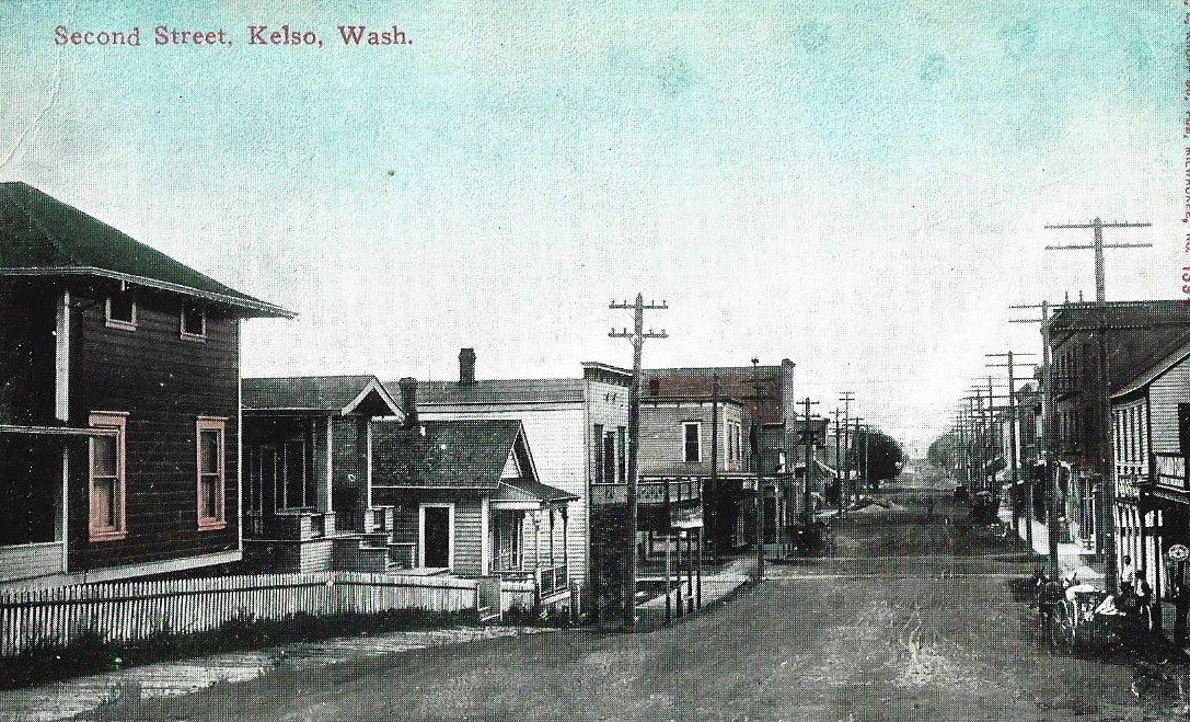
2nd Street, Kelso in the late 1890's or early 1900's, possibly looking south just north of Allen Street. Today 2nd Street is Pacific Avenue, part of the Pacific Highway through Kelso. Nothing in this photo remains today.
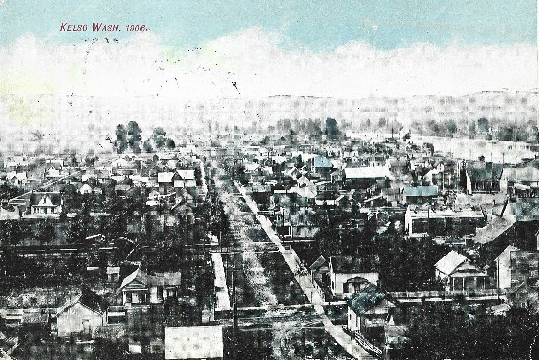
Kelso 1906
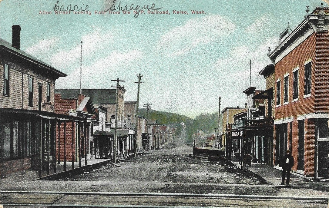
Allen Street looking east from the railroad tracks in 1908.
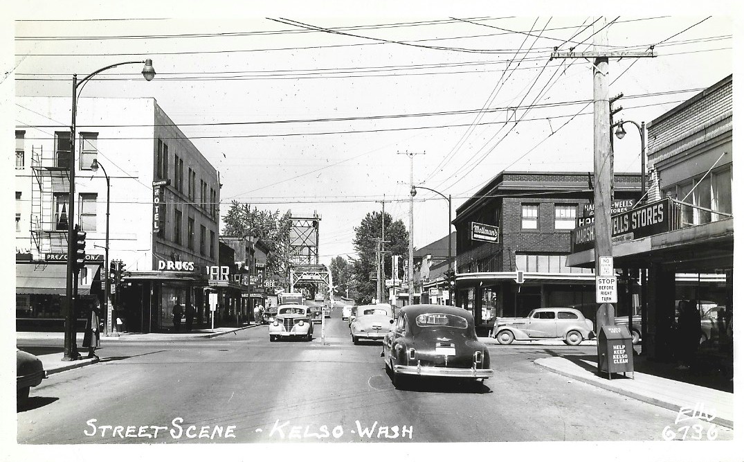
Allen Street looking west across the Pacific Highway
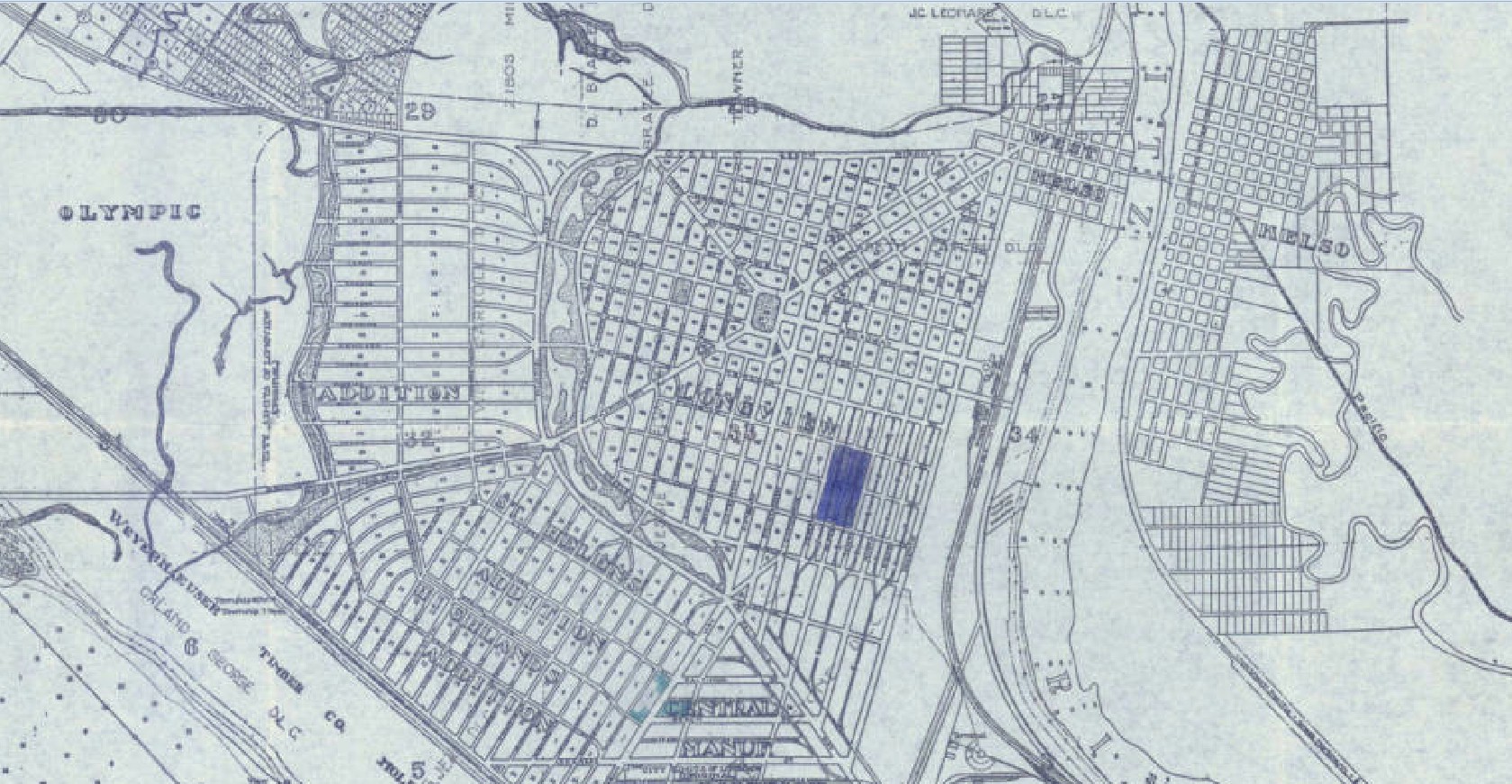
1925 map of Kelso-Longview 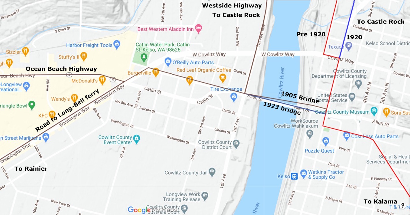
2020 map 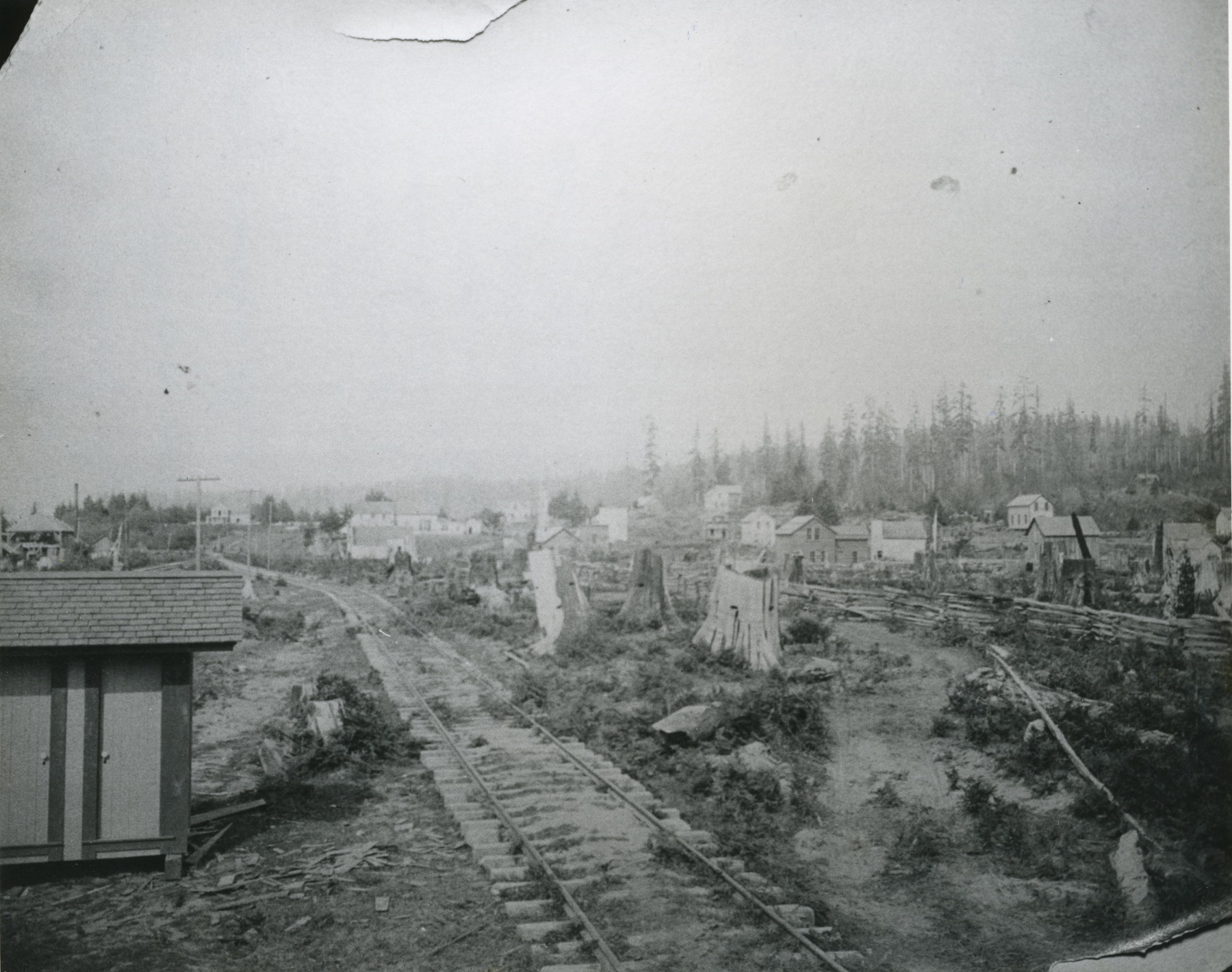
Kelso 1887 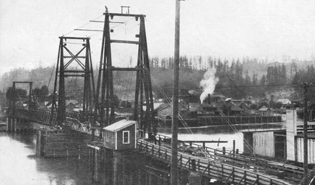
First Kelso bridge |
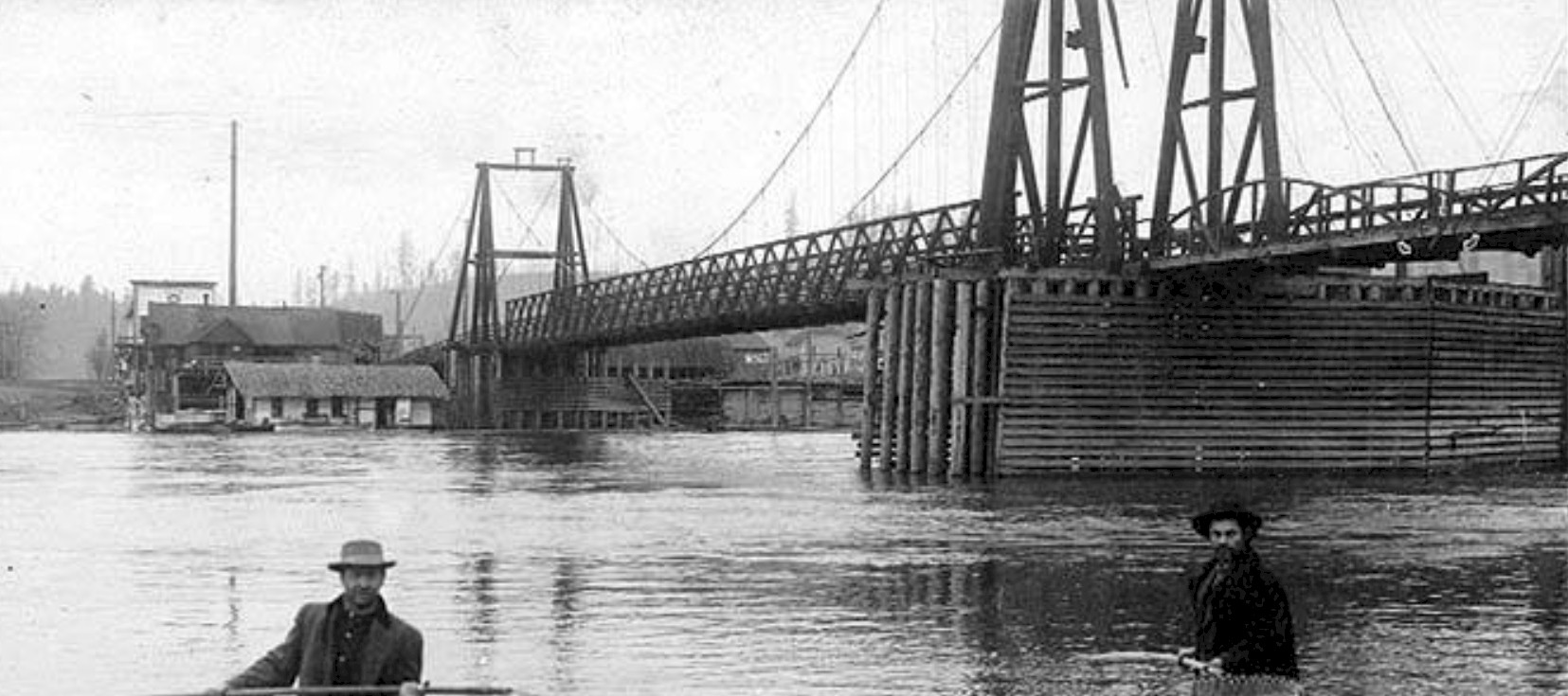
First Kelso bridge 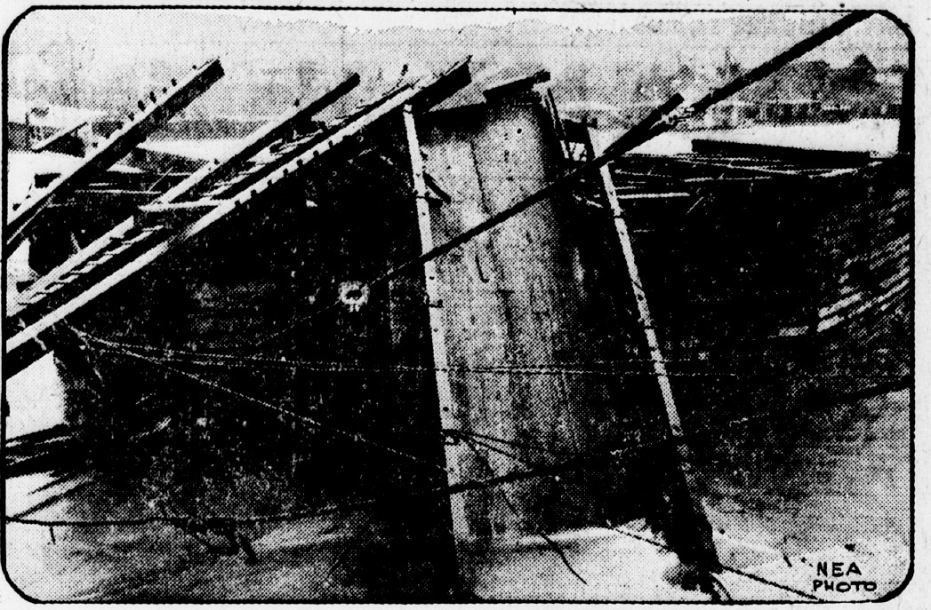
1923 bridge collapse 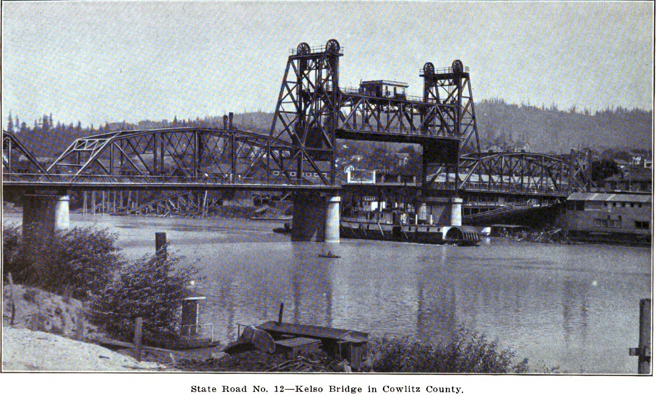
1924 New Kelso bridge 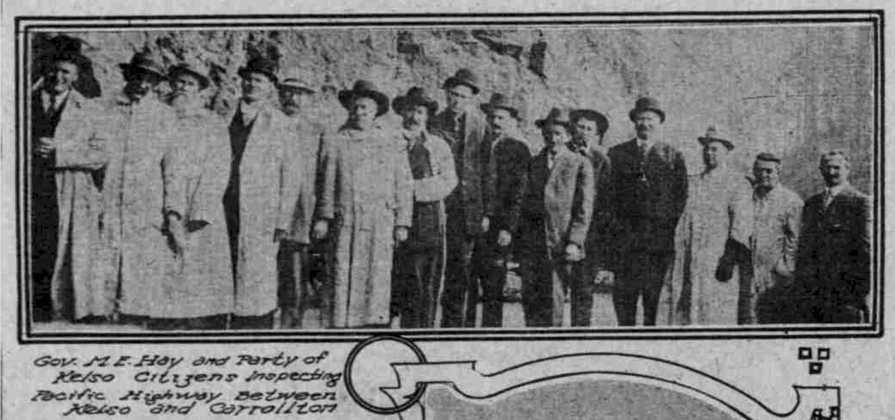
Governor Hay and Kelso citizens at Carrollton Hill in 1912. |