![]()
The Historic Pacific Highway
in Washington
Freeport
![]()
The Historic Pacific Highway
in Washington
Freeport
History of Freeport in Cowlitz
County
By Curt Cunningham
The town of Freeport was located on the banks of the Cowlitz River opposite of Kelso near today's Hudson Street in Longview. The first settler to this area was in 1847, when Peter Crawford took a claim on the east side of the Cowlitz River where he later founded the the City of Kelso. Two years later in 1849 Jonathan Burbee, Nathaniel Stone, Henry "Uncle Darby" Huntington, Royal C. Smith and Seth Catlin, took claims along the river opposite Crawford's place.
In November of 1849, Lucia Almire Huntington passed away and was buried on a steep hillside once known as Goat Hill. Lucia was the daughter of Uncle Darby and his first wife Zervia who died in 1846 in Indiana. This gravesite was the beginning of the Catlin Cemetery, which is the oldest cemetery in Cowlitz County that is still used for internment. The cemetery has over 150 marked graves and numerous unmarked ones. The cemetery is also a resting place for many of the Cowlitz Tribe, who are located in the southwest corner. Pioneers, Harry "Uncle Darby" Huntington, Nathaniel Stone, William A. McCorkle and Seth Catlin are all buried at this cemetery.
In 1852, Seth Catlin, who became known as the "Sage of Monticello" was elected to the Oregon Legislature to fill a vacancy in the council caused by the resignation of Columbia Lancaster. Catlin also became a member of the first Washington Territorial Legislature, and was elected president of the upper house. Judge Catlin continued to live on his claim for the remainder of his life and died on July 25, 1865.
In 1866, Nathaniel Stone platted out the town of Freeport naming it after his hometown of Freeport, Indiana. The town was located a little over a mile upstream from Monticello. The next year in 1867, the Cowlitz River flooded and Monticello was almost completely washed away. Freeport, which was on higher ground sustained less damage.
Freeport's first school was built in 1866 by Charles Forsythe who also taught the students. It was the second school built in the county at the time. The schoolhouse lasted for 73 years when it was torn down in 1939.
On November 1, 1868, mail route #15415 began service between Vancouver and Freeport. The mail was sent from Vancouver on Saturdays at 8am and it arrived at Freeport on Mondays at noon for transport to Olympia on the stages. The southbound mail left Freeport on Wednesdays at noon and arrived back at Vancouver in the afternoon. The establishment of this mail route became necessary and 2 new post offices were created on the route, between Pekin and Freeport. One was at Kalama and the other was at Martins Bluff.
Steamers began to make regular trips between Monticello and Portland in the early 1860's. After the flood of 1867, the steamers began to regularly land at Freeport. In 1868, a traveler going from Freeport to the Cowlitz Landing described the trip north.
"Being at Freeport the other day, and having occasion to cross over to Olympia, at the request of a friend, coupled with a curiosity to observe the scenery on the Cowlitz River and the prairies, boarded the steamer Rainier, under the control of Captain Kerns, who made the trip to the Cowlitz Landing in a little over 10 hours. Going down river only takes about 5 hours, including stops."
By 1871, most of the businesses at Monticello had moved north to Freeport. Memory of the flood made people realize that Monticello was vulnerable to another disaster. This made Freeport the starting point for passengers and cargo going through the Cowlitz Corridor between Portland and Toledo. That year, Charles Catlin established a post office at Freeport and during the summer, the county seat was moved to Freeport and for the next 17 years, the town was the main commercial hub on the Cowlitz River.
U.S. Army Corps Engineer Robert A. Habersham visited the town on February 18, 1880 and said that; "The most important place on the river is Freeport, formerly Monticello, 3.5 miles from its mouth. It has a population of 300, with 2 stores doing a general merchandise business. There are 55 families residing in and around the town. The population of the Cowlitz Valley has increased 50% within the last 5 years. The area under cultivation along the river banks is 26,000 acres. The exports are; lumber, shingles, cattle, hogs, grain, vegetables and general farm and dairy produce. During the last year 11,000 passengers and 15,000 tons of freight were transported by the 2 steamboats which run regularly, making daily trips on the river."
During the summer snow melt of 1880, the Cowlitz River rose and broke through the levee at Freeport. One of the oldest residents of the area said he had never seen the river so high at this time of year. The force of the raging water broke up a log boom 12 miles above town and 150 feet of levee at the lower end of the village succumbed to the tremendous force of the waters and in an instant, a large part of the river was flowing through the farmers fields. Over 500 acres of grain and grass was destroyed.
In the 1880's, Captain Joseph Kellogg who owned the Kellogg Steamship Company began running the steamers, Joseph Kellogg and the Toledo between Portland, Monticello, Freeport and up the Cowlitz River as far as the new town of Toledo that was named after Kellogg's boat.
The Kellogg Company was described as such; "Every member of the company, from captain to engineer, and from purser to shipping clerk, is a member of the Kellogg family, and a happier or more harmonious company never navigated a river, or hardly ever ran a newspaper. The Joseph Kellogg plies between Portland, on the Willamette, and Freeport and Toledo on the Cowlitz, and touches at intermediate points wherever it has business."
"Freeport and Toledo are mere villages, but the country around them is thickly settled and trade is good. The lands are exceedingly fertile, being subject in many places to overflow during the spring and winter freshets. The prices in the neighborhood of Freeport range from $50 to $60 per acre, but, there are many partially improved farms within a radius of a half a mile, which may be had at $5 or $10, or even less, per acre. The Cowlitz River, like the Willapa, is as large at its mouth as the Willamette, but neither is navigable for large steamers for nearly so great a distance."
Catlin
In the early 1880's, the towns of Kelso and Catlin came into existence. Catlin was located about a mile north of Freeport on the claim of Seth and Mary Catlin. By 1889, there were enough people who had settled in the general area that a new town had formed and it was known as Marysville. Unfortunately there was already a town in Washington by that name so in 1892, the citizens changed the name of the town to Catlin in honor of the "old Sage."
During the summer of 1898, Captain Kellogg was constructing a large 400 foot long wharf with a 90x30 foot warehouse at Catlin. The company built the wharf for its own use and also for the benefit of the citizens and the large farming community as well. Before the wharf was built, farmers would have to haul their produce to Freeport to have it loaded for the markets in Portland.
The first bridge across the Cowlitz River between Catlin and Kelso opened on October 20, 1905. The bridge was a cable suspension structure with a 100 foot knuckle or jack knife draw, built in 2 parts of 50 feet each. Each part was attached to the bridge at either pier with hinges and was counterbalanced with boxes filled with sand suspended between the piers, 80 feet above the water. This made it easy to raise and lower the bridge. There was an 8 horse motor that powered the bridge and it could be opened and closed in a minutes time. This bridge was the first of its kind in the Northwest and was 700 feet long including the approaches.
On November 15, 1906, after a heavy rainstorm, the Cowlitz River overflowed its banks and washed away most of Catlin. The river was 20 feet above the low water mark, which took several lives and caused millions of dollars in damage. The flooding waters knocked down many telephone poles and all communication between Portland and Seattle was cut off. The newly built bridge between Catlin and Kelso was washed away due to the large build up of debris. The only bridge left in the Cowlitz Valley was the one across the Toutle River.
The greatest danger was to the fishermen who lived in house boats at the mouth of the Cowlitz and the farmers at Lexington, which is located 2.5 miles north of Catlin. Lexington was under 7 feet of water and because the river rose during the afternoon, it gave the residents enough time to escape to higher ground. About 8 families totaling 30 people were rescued by the steamer Georgia Burton that was quickly sent from Portland.
Railroad traffic between Portland and Seattle came to a standstill and the furthest north the trains could reach was Castle Rock. The furthest south was at Olequa. Railroad passengers were taken up on steamers from Castle Rock to Olequa and then the boats would bring the southbound traffic back to Castle Rock. The arriving southbound passengers told of the Cowlitz Valley being a vast inland ocean for miles, and the only visible land in the valley was the railroad grade stretching like a ribbon across it.
By 1908, Catlin had become a small city and that year, it was annexed into Kelso. Today, Catlin is known as West Kelso. Freeport lasted until 1927, when it was unincorporated and was absorbed by Longview.
Today, there are a few surviving houses of the original town of Catlin and there is one surviving building from the town of Freeport, which is now a private residence located on Hudson Street next to the river. The intersection of Hudson Street and River Road is about the center of Freeport and Catlin Street near the Kelso bridge was the center of Catlin.
The old house in Freeport is said to have been built in 1865 and was at one time a store and the post office. The current resident, who is not quite sure when the house was constructed, said that when it was built, the front of the house faced the river as that was the highway. It was first thought that years later the house was turned around to face the Military Road but the owner said that they just built a front porch on the back of the building making it the front.
The old Military Road is still unpaved for about 100 feet directly in front of the house. This is is now used as a driveway for county vehicles. Hopefully the building gets saved along with the little piece of the V & S road and they get added to the historic register.
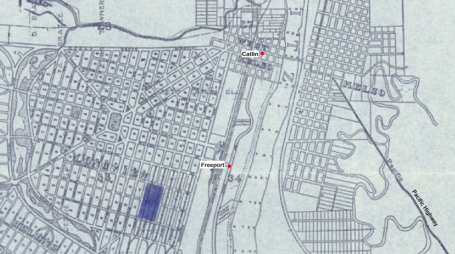
1925 map of Longview and Kelso 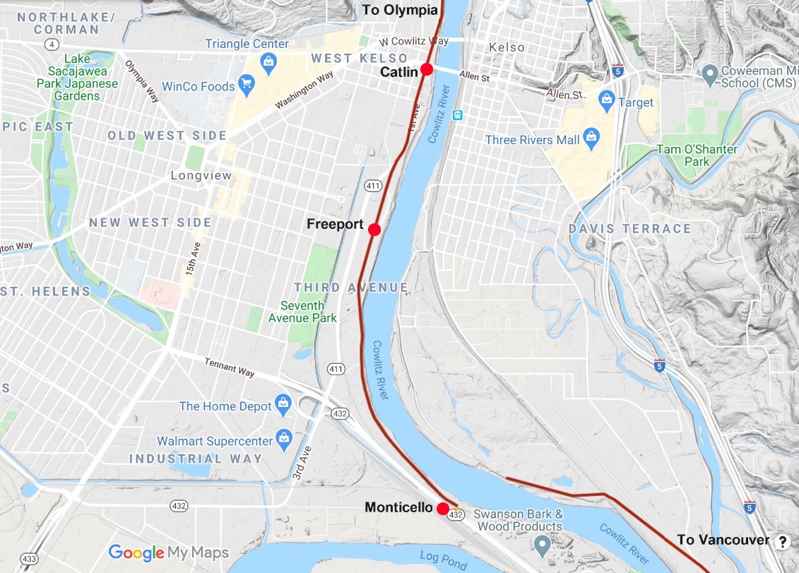
2020 map showing the old towns. 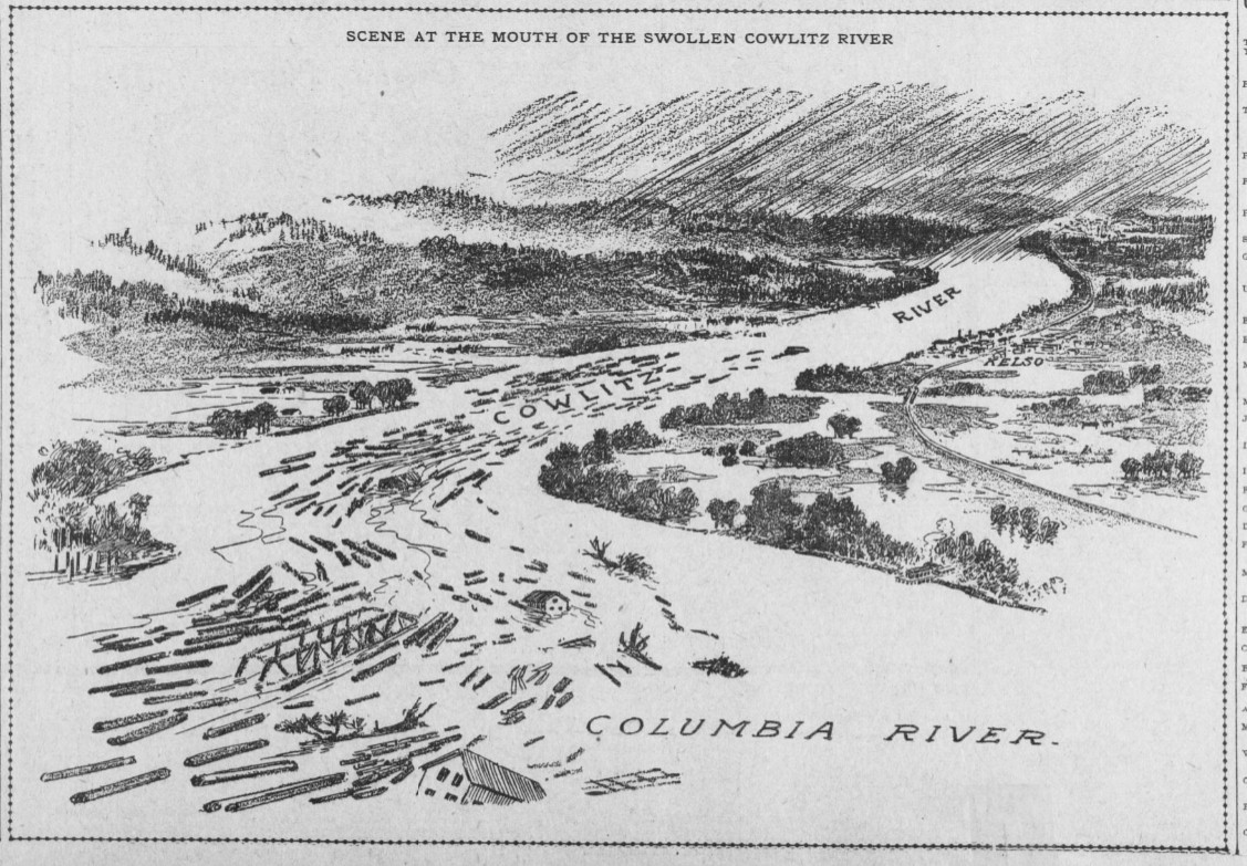
The 1906 flood. 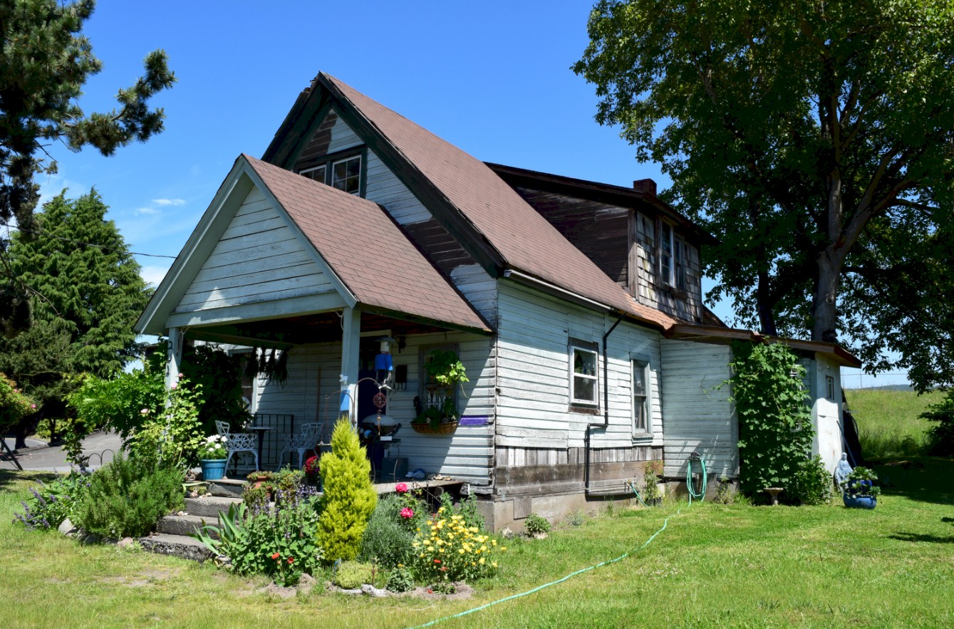
The Freeport House 2020 |
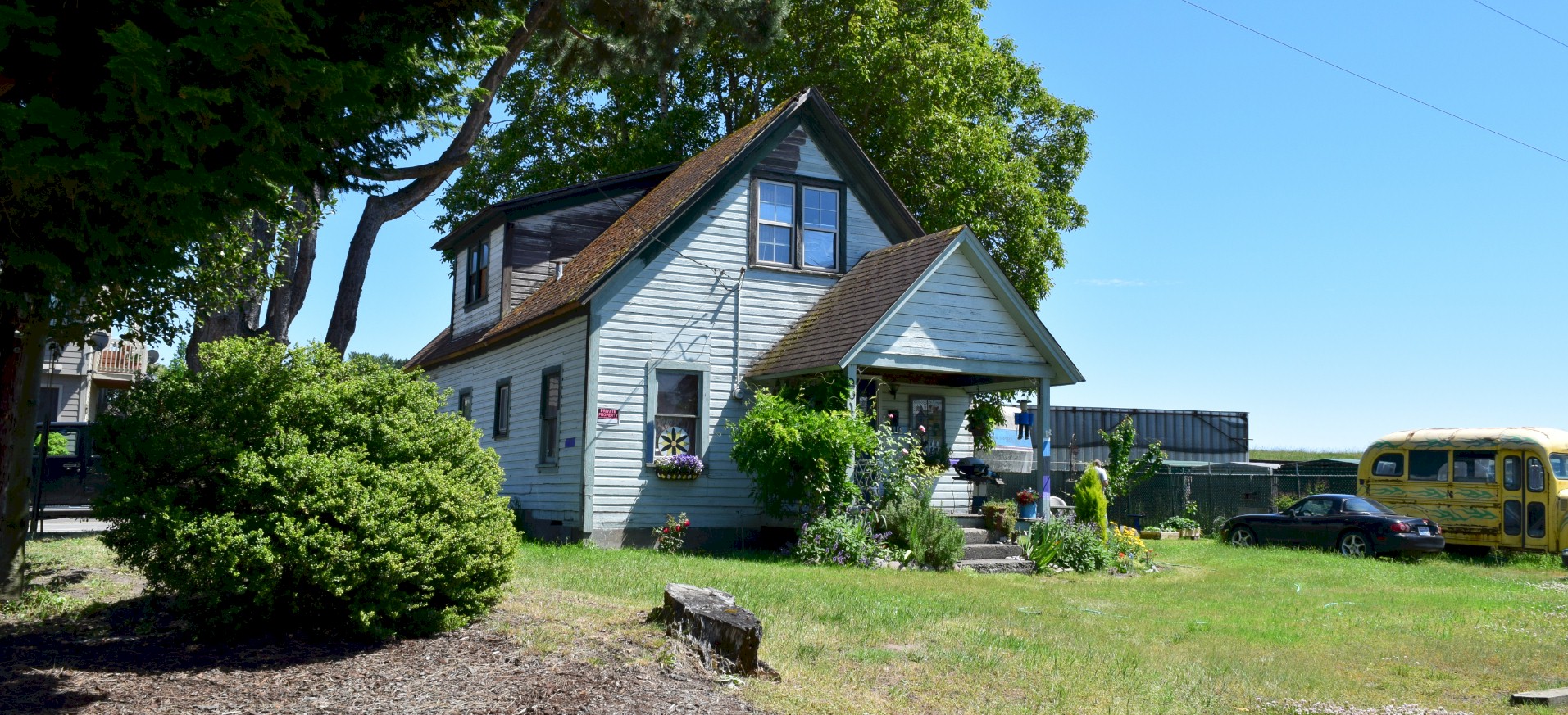
The Freeport House 2020 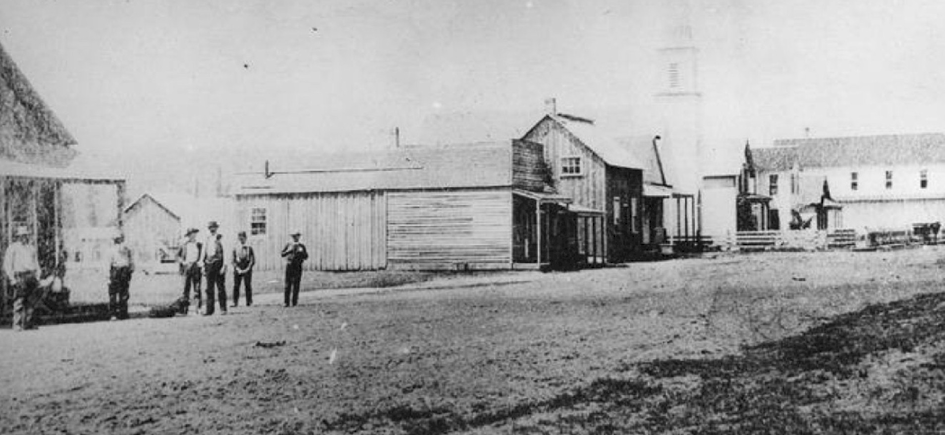
Freeport 1873, looking south. The Military Road is in the foreground. 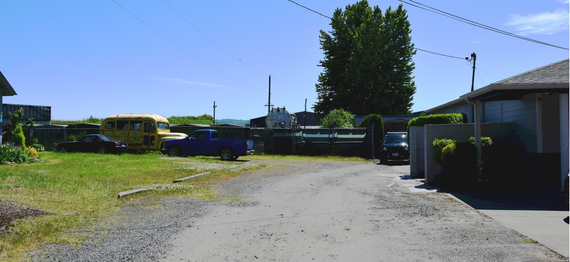
Military Road in Freeport. Looking south with the old house on the left out of the picture. This could be a close match to the old photo. 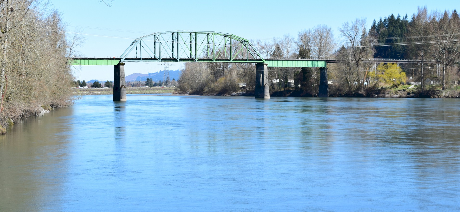
Looking upriver just north of Catlin. Lexington is in the distance under the bridge, and Rocky Point is on the Right. |