![]()
The Historic Pacific Highway
in Washington
Seattle South 1854 - 1909
![]()
The Historic Pacific Highway
in Washington
Seattle South 1854 - 1909
History of the Early Highways
leading into Seattle
By Curt Cunningham
The Five Rivers
The Duwamish and White river valleys are located between Auburn and Seattle, and together they are about 20 miles long. The White river valley is now the Green river valley and lies between Auburn and Renton Junction which is located in southeast Tukwila. (This is where SR-181 crosses Interstate-405) The Duwamish river begins at the old confluence of the White and Black rivers .75 miles north of Renton Junction. In the 1850's this place was known as the forks of the White river.
Before 1899 the White river flowed northward from Auburn and emptied into Elliot bay. Back then about a mile east of Auburn, the White river diverged and the southern branch was called the Stuck river which flowed south to Puyallup. From Auburn to Tukwila it was known as the White river, and from Tukwila to Seattle it is known as the Duwamish river. After 1899 the White river began to flow south and absorbed the Stuck river.
In the 1850's before any good roads were constructed from Seattle to the Kent valley, the farmers would hire Indians to transport their produce down the river in their canoes, and between 1856 and 1886, small steamers would ply the Black and White rivers, and would load and unload at the various landings located along the river. The White river was navigable by small steamers for about 40 miles up stream to Brannan's farm in northeast Auburn. Steamers could make it up the Black river into Lake Washington. The first roads in the valley were built to these landings. For a short time in the 1860's coal from Newcastle was loaded onto a steamer in Lake Washington and it would travel down the Black and Duwamish rivers to Seattle. The Black river bridge in Renton which was built in 1860, was constructed with lumber brought up the river by the steamer Ranger.
The First Roads South of Seattle
The first wagon roads south of Seattle followed the trails made by the Duwamish and Muckleshoot people. The first one was not so much a road but more of a pack trail and was called the Ridge Road. This trail ran over Beacon Hill and continued along the ridge to Skyway. This was the Indian trail from "Elliott bay to the mouth of the Cedar river." This trail had evolved into a wagon road by the 1870's. It began in downtown Seattle and traveled south up what is now Beacon Ave. S., and roughly followed it to Myrtle Street. From there the road followed Myrtle Pl. down the hill where it turned to the south and connected to Renton Ave, and roughly followed it to Renton. By 1880 this road was impassable.
From Renton the Na-qui-a-ka trail which led from the "mouth of the Cedar river to the falls of the Snoqualmie," would evolve into the Snoqualmie Road in 1865, and from that time until the late 1880's this was route the cattle were driven on from Ranger's prairie in North Bend to Snyder's slaughterhouse which was located on the Beach Road about 2 miles south of Seattle.
There was another trail from Renton which ran up Benson hill and continued southeast to Jenkins's prairie in Covington, where it connected with the trail coming from Tacoma. In the 1860's prospectors from Puget Sound who were on their way to Canada and Colville used the combined trail which traveled eastward from Covington up the Cedar river to Rattlesnake lake, which back then was a prairie. From there it was east over Yakima pass to Lake Keechelus.
The first actual wagon road in King county was constructed in 1854 called Tobin's Mill Road. This was not an official county or Territorial road. It began at Yesler's mill in Seattle and terminated at Tobin's mill in Renton. From Yesler's mill it ran southeast around the mudflats to the foot of Beacon hill and followed along the bottom of the hill south to the mouth of the Black river at Tukwila. Here it turned east and began to climb up the hill, and then follow Sunset Blvd. down the hill to the west end of Tobin St. in Renton. This is where the mill and the old channel of the Black river was located.
During the War of 1855, the mill was burned to the ground and the area became deserted. Tobin died in 1857, and Dr. Biglow moved away. Tobin’s wife Diana, married Erasmus Smithers, who settled next to a Muckleshoot village, which is now the Fred Meyer store in Renton. The Smithers' at one time had owned 480 acres in the valley surrounding Renton. In the 1870’s, when the Indians were being forced onto reservations, Diana Smithers protested the removal of the Indians living on her land, and they were allowed to remain there.
The third road leading into Seattle from the south was the Military Road which was also also known as Territorial Road #4. Construction began in 1857 and it was to be a connection with the Military Road to Walla Walla in the hopes that it would help bring in new settlers to the Seattle area. It didn't work out as planned because the Walla Walla road failed to bring in many settlers. In 1859 the Military wanted a road between Fort Steilacoom and Fort Bellingham and they used Territorial Road #4 to Seattle. The U. S. Government shut down the military road program before the road could be finished, and construction only made it as far as Snohomish.
The Military Road crossed the Duwamish river at Allentown close to where the 42nd Ave S. bridge is located. The ferry may have been established in 1860 or 1861. Records show that on January 3, 1862, J. W. Grant was issued a license to operate a ferry across the Duwamish where the Military Road crosses the river at Joseph Foster's claim. Cyrus C. Lewis was also authorized to collect ferry tolls. This may be because C. C. Lewis was the first to settle on the land opposite Allentown. Joseph Foster had later claimed or purchased land at the crossing sometime after C. C. Lewis did. So there must have been some kind of agreement between the parties. It is unknown at this time how long this ferry operated. The ferry license was good for only 5 years, and I could not find out if it was renewed.
Also in 1862 Christian Clymer petitioned for a road which became County Road #13. This road began at the ferry in Allentown and traveled east up the hill which is now S. 129th St., and followed S. 133rd St, as it veers right onto S. 134th St., and continued down the hill roughly following Langston Rd. to the Black River bridge in Renton. This bridge was completed in 1860, and was the only crossing of the Black river in Renton until the bridge at the west end of S. 3rd St. was completed in 1878.
The next wagon road connected Seattle with New York.... No, not "Gotham City," but a place better known as Alki Point. New York was a short lived settlement which was established before Seattle was founded. On September 26, 1851, John N. Low, Lee Terry, David T. Denny and Captain Robert C. Fay arrived on the Schooner Exact, at Alki Point and staked their claims. Low then sailed back with Captain Fay to Portland to retrieve their families, leaving Terry and Denny to build a cabin. Alki Point, is an outcropping of land located southwest of Elliott Bay and is the western most landform in what is today known as West Seattle.
The Duwamish who lived in the area called West Seattle, Skwudux and Alki Point was called Smoquamox. Alki in the Chinook Jargon, means "some time later," “by and by,” or “maybe in the future, we will see.” On November 13, 1851, The schooner Exact, returned to Alki Point and 22 families disembarked with all their belongings onto the beach. Among the passengers were; Arthur A. Denny, William N. Bell, Carson D. Boren, and Charles C. Terry. Some of the other passengers who disembarked the Exact that day were; James M. Hughes, who went on to Steilacoom, Daniel R. Bigelow, who staked a claim in Renton and later in Olympia, Horace H. Pinto and family, who started a farm at the Cowlitz Landing, and John Alexander and his family, along with Alfred Miller, took claims on Whidbey Island.
Low and Terry platted a settlement at Alki Point, they called New York, Terry was hoping the name would attract more settlers. On March 31, 1852, Dr. David “Doc” Maynard arrived at New York from Olympia and was going to start a salmon cannery there. By April, Denny, Boren and Bell had convinced Maynard to become a permanent settler of Seattle, and they rearranged their claims so Maynard could take some land on the south side of Boren’s. He ended up practicing medicine instead.
After Lee Terry left New York in March of 1852, Charles Terry renamed the place Alki. This was because the name New York proved to be bad for business. During the summer of 1852, Charles Terry opened the first store at Alki and called it the Markook House. Terry advertised that northbound ships are now able to load up piles, timber and shingles for the markets in San Francisco. The town of Alki at it’s peak, had a sawmill, a public house, and two or three stores. In 1853 Captain William Renton started a sawmill but was persuaded a year later to move his operation to Port Orchard after he realized Alki wasn't the best spot for a mill.
By the 1860’s, Alki was mostly abandoned as the businesses had moved to Seattle which had a better and deeper harbor. Alki is exposed to the winds which would frequently wash ships ashore. Charles Terry, would later move to Seattle, where he died in 1867. John Low left the area for a few years but returned and settled in Seattle. The fledgling village of New York tried to be a city but it was laughed at by the visitors who called the place; “New York—Alki,” meaning, it might be a city someday “by-and-by.” Today the "New York" on Puget Sound is now mostly forgotten. In 1902, 50 years later, Alki became a part of West Seattle, and in 1907 West Seattle was annexed into the City of Seattle.
The road From Seattle to Alki was constructed about 1859 or 1860 and followed Tobin's Mill road to the ferry crossing in Allentown. This became County Road #5 and Territorial Road #1, and was known as the "Beach Road." This is because the road ran along the beach between Dearborn and Spokane streets. After crossing the Duwamish river at Allentown, the road traveled back north along the foot of the west hill to the intersection of E. Marginal Way and Puget Way SW. This is where it climbed up the hill to SW Dawson St., and then traveled in a northwest direction through West Seattle to the intersection of Bonair Dr. SW and SW Massachusetts St., and followed Bonair Dr SW to Alki.
People didn't like the road much because it was too long. You had to travel about 10 miles out of your way to reach Alki from Seattle. It was almost 8 miles south to the ferry, and then about 9 miles back north to Alki. In 1862, Doc Maynard wanted to make a shorter route between Seattle and Alki. County Road #5 wasn't used much and the road barely lasted a year. This was about the same time Alki was on it’s way out, and the road just faded back into the forest.
On February 19, 1862 the petition to build a new and shorter road to Alki was submitted to the county. The road began in Seattle and ran east to 7th or 8th streets and then traveled south to the city limits, and then along the shoreline to the north line of John J. Moss' claim. From there it ran in a southerly direction to Georgetown at about Lucile St., and turned west and crossed the river at South Park. From there it connected to the old road to Alki. The road would be completed on November 12, 1862.
In the 1870's the ferry at South Park became known as Miller's ferry, and it remained in operation by H. H. Miller until the bridge was built in 1890. It is unknown who first operated the ferry at the South Park crossing or if it was just a ford in the beginning. This ferry crossing was located near the southern end of 8th Ave. S. in Georgetown.
County Road #57 - H. H. Miller Road
In 1876 the Seattle & Walla Walla railroad was building its line from Seattle to Newcastle, and they had plans to place the tracks over the Beach Road through the narrow one mile passage between the bay and the bluff. Today this would be between Horton and Atlantic Streets. This was going to make travel through this section extremely difficult. So in 1877 ferryman H. H. Miller among others petitioned the county for a new "Beach Road" to be built from the southern city limits of Seattle to the Black river ferry in Tukwila which was operated by Joseph Foster. This road became County Road #57 known as the H. H. Miller Road.
On March 3, 1878 a contract was awarded to build a bridge over the Black river at Foster's ferry. The bridge was built on piles 240 feet long and extended from the road on Foster's place to Jorgenson's Farm on the opposite bank. The pile driver Dick Atkins was immediately sent up the Duwamish to begin work. The bridge was completed by the end of that summer.
On April 24, 1878 the newspaper said that there were a number of shaky bridges along the Duwamish road, notably those at the Collins and Terry farms. The rotten and dilapidated condition of the planks and timbers rendered travel over them especially on a dark night, extremely perilous to the life and limbs of both horses and riders.
On February 15, 1879 at a meeting of the Board of Trustees of the Seattle & Walla Walla Railroad, they adopted a resolution to construct a new Beach Road in the vicinity of the tracks where the wagon road had been taken by the railroad, and to make this section as good or better than the old road was before the tracks were laid. They also agreed to build a fence along this portion of the new road as it would only be a few feet from the tracks creating a potential dangerous situation.
On August 22, 1879 the viewers report said that the road began at the southern boundary of the city of Seattle near the Hanford claim, and then following along the old road until they arrived at the railroad tracks. From this point south, the tracks were laid on old Tobin's Mill road. The new road now had to cross the tracks and follow them southward until it arrived at the upper end of Byrd's orchard, and opposite the long bridge on the Terry farm. From here Road #57 crossed the long bridge and followed the old Mill road to Steele's Landing, passing in the front of Steele's barn and house. From Steele's the road followed the old Mill road to the ferry at the mouth of the Black river. This new road was completed on May 3, 1880.
On June 24, 1882, Joseph Foster sent in a letter to the editor of the Seattle Post-Intelligencer. He was writing in regards to the condition of the Duwamish river road, which he said was supposed to be the only road leading to Seattle from the farming districts; "I would ask in the name of the people of Seattle can they not afford a better road than that? There is not one man living on the Duwamish Valley today that would be unwilling to lend a helping band, not expressly for their own use; but for Seattle people as well. There is a beautiful road leading out of town as far as Synder's slaughterhouse. City people, are you not ashamed to have a highway like this leading to your door and place of residence? There is one man living in Duwamish, not six miles from town, who asked the richest citizen of Seattle how much he would give towards fixing the town end of that road, and the answer was; "he would be dead if he would give a cent." I wish to say to this man, "Don't give a cent, but give by the hundred or thousands," and you will oblige an old resident on the Duwamish." said Foster.
On June 14, 1887 the county placed an ad calling for bids for the grubbing and clearing of all stumps for a width of 60 feet from the city limits to the Meadows race track. From Corson Ave., the road was to be 30 feet wide to the Duwamish river bridge.
County Road #8 - Allentown to Auburn
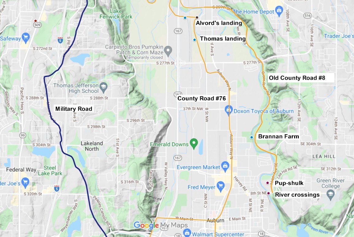
In 1861 County Road #8 was established from Foster's ferry at the mouth of the Black river to Pup-shulk prairie. The road followed the old military pack trail which ran between Fort Dent, which was located at the Black river crossing, and Forts Pike and Posey which were established in 1856, and were located at the crossings of the White and Green rivers. This is where the White and Green rivers merged. Trails going between Tacoma, Covington, and the Muckleshoot prairie crossed the White and Green rivers near S. 320th Street. Today, the beginning of County Road #8 would be where Monster Rd. crosses the Black river in Tukwila, and then it followed along the east side of the Green river south to Pup-shulk which was located a little north of the intersection of S. 320th St., and Lea Hill Rd. SE in Auburn.
County Road #8 will become known as the White River Road and the Territorial Road. At Pup-shulk, the trail forked, with the left fork climbing the hill toward Covington, and the right fork continuing south across the Green river and continued southeast up the hill to the Muckleshoot Reservation. SR-164 from Auburn to Enumclaw roughly follows this old trail.
Pup-Shulk which is also spelled Pop-Sholku, was the name of the little prairie on the east side of the river just north of S. 320th St. in Auburn. This was also the site of a village called Pup-shulk. I am not sure if this village was Duwamish or Muckleshoot, as they both had villages along the river from Auburn to Renton.
On page 476 of the 1903 book The United Service Volume II of the third series. It talks about the events during the War of 1855 which led up to the death of Lieutenant Slaughter at the forks of the White and Green rivers on December 5, 1855;
"The march of the expedition after leaving Steilacoom to Muckleshoot was devoid of interest, and after a brief rest at that prairie (Muckleshoot) proceeded down the valley of White River, every precaution being taken against surprise, and notwithstanding the constant fall of rain, neither tents nor fires were permitted until their arrival at the Pup-shulk Prairie, near the forks, where, on December 4, meeting with Captain Hewett, and being assured by that officer of the absence of Indians, his company having thoroughly scoured the neighborhood during the day, Lieutenant Slaughter ordered his men to encamp for the night."
The following day at 10am the camp came under attack and Lieutenant Slaughter was killed. The town of Auburn was originally named Slaughter but it was changed to Auburn in later years.
In the County Road #8 packet, there is a letter written on April 20, 1861 by H. P. Bryant which described the route; "Commencing from Pup Shulk, thence down said river (White) on the east bank in a northerly direction to Brannan's farm, thence north and west to D. A. Neely's farm, thence north across said farm, thence north to near Henry Adams house, thence northward to the confluence of the White and Black rivers, thence northwesterly to the Territorial road at Bennett Johns."
In 1893 County Road #8 was resurveyed and in some places small changes were made. The road now began in Allentown and followed the Beacon Coal Mine Rd. and crossed the bridge at the mouth of the Black river. From there the road followed the meandering of the river, and terminated at the intersection of 1st Ave, S, and S. 259th St. south of Kent.
In 1907 County Road #8 was abandoned from S. 180th in Orillia to S. 212th in Kent. This was because a new road was constructed down the center of the valley which is now known as SR-181. Today, Beacon Coal Mine Rd. and Russell Road in Kent are a remnants of this old road.
County Road #70 - Michael Kelley Road
On November 6, 1877 Michael Kelly and Henry Wood petitioned for a road to be built from Normandy Park in sec. 31, twp. 23N, range 4E, to the west bank of the Duwamish river at the old crossing of the Military Road in Allentown. They offered to pay construction expenses if the county refused their petition. The road would be approved and was completed in 1878 between Normandy Park and Riverton.
County Road #70 known as the Michael Kelly Rd., began in Normandy Park at William H. Brown's farm which was at the time owned by George Ouellette, and it traveled east to the old Military Road crossing of the Duwamish in Riverton. From SW Normandy Terrace Rd. the road followed Normandy Road to Des Moines Memorial Drive. Then it followed Des Moines Memorial Dr. north through Sunnydale, and then veered northeast to the intersection of S. 133rd St. and 32nd Ave. South. Today the section of S. 142nd Pl. near Tub lake is part of old Road #70. It then followed S. 132nd St. down the hill to the intersection of S. 128th St. and Macadam Road in Riverton
County Road #70 began to be chopped up in the late 1900's. This is when the roads in this part of the county began to be straightened out into blocks. In 1907 the first section of Road #70 was vacated when the Riverton Acre Tracts was established. The Springbrook addition to Riverton had incorporated Road #70 into their plat which is now S. 132nd Street. The remainder of the road was vacated by 1918.
County Road #76 - Miller's Ferry to the Kent Valley
In 1878 County Road #76 known as the George Frager Road was designated. It was also known as the "Bluff Road." This road ran south from Miller's ferry at South Park to the farming community of Pialschie which was about 2 miles south of Kent.
The road climbed up out of the Duwamish valley at the McKinley place which was located on E. Marginal Way where Roseburg Ave. S. used to connect with it. The road then followed Roseberg Ave, up the hill to S. 116th St., where it veered left onto Military Road S. and followed it up the hill to the intersection of S. 140th St. and 33rd Ave. South. This section was never the actual Military Road but rather an extension of the old road which was designated in 1928. At this point the old Military Road continued east down the hill to Allentown, which became County Road #70.
County Road #76 continued south along the edge of the bluff following the Military Road to S. 188th St. just north of Angle lake. From here the road descended the hill on a 22% grade to the farm of Julius Mess. At the bottom of the hill, the road met the White river and followed up its western side to the village of Thomas, which was a settlement founded in 1852, by John Thomas and Ephraim McFarland.
From Thomas the road continued south to James Boyd's place at Pialschie which was located at S. 277th St. and B St. NW north of Auburn. In 1886 County Road #76 was extended south from Pialschie to the county line and connected to the Indian Ferry-Stuck Valley Road which continued on to Tacoma. In 1905 County Road #76 was relocated from the top of the hill north of Angle lake to the valley floor on an easier grade. The road on this steep hill would be abandoned by 1920.
Today most of Frager road still exists as other roads except for the section on the steep hill which was abandoned. In the valley near Kent on the west side of the Green river the road retains its original name.
County Road #88 - Joseph Quinn Road
In the spring of 1880 Joseph Quinn petitioned for a road from Sunnydale to the White River road which became known as County Road #88 or the Joseph Quinn Road. In 1912 this road became a section of the Highline until the new alignment which is now called Des moines Memorial Drive was completed. Roseberg Ave. S. is a remnant of old Road #88, and it was originally known as Michel's logging road between S. 128th St., and S. 116th Street.
County Road #88 began in Sunnydale at the intersection of Des Moines Memorial Drive and S. 160th St, and roughly followed Des Moines Memorial Drive north to Roseberg Avenue. This section was realigned in 1915. Just before the road reached S. 128th St. it veered to the right and connected with Roseberg Avenue. The little section in the park was vacated in 1917. This is about where this road connected with Michel's Logging Road and followed it down the hill to the White River Road at S. 116th Street.
The Tacoma-Seattle Boulevard
Bicycles gained popularity in the Puget Sound area beginning in the 1890's. Wheelmen as they were called were beneficial to the development of the first good road between Olympia and Seattle. Bicyclists from Olympia had improved the road between Olympia and Lacey in the late 1890's, which would become a section of the Pacific Highway. Bicyclists in Tacoma wanted a good road to Seattle as well as Olympia, and Seattle bicyclists wanted the same.
In the spring of 1897 the "Tacoma-Seattle boulevard" which the bicyclists of both cities had been talking and planning for the past 2 years was near its completion, and their dream to have a good road between Tacoma and Seattle which bicycles could travel on with ease was becoming a reality. The promoters were hard at work perfecting their plans, and the Seattle people were in good spirits. It was thought that 2/3rds of the stock in the road was owned by Seattle cyclists. Tacoma hadn't been thoroughly canvassed as they were waiting to hear about the tide-flat proposition which was to be discussed. In Tacoma there were 2,500 cyclists.
The road was finished in August of 1897, although it needed much more work to make it a good road, and the promoters promised they would continue to improve it. The route was 31 miles long with a right-of-way 60 feet wide. There was a 10 foot bicycle path in the center which was to be made of clay, fine gravel or cinders, which was crowned to allow drainage. Work was being pushed rapidly and planking across the old trestle of the South Seattle Railway was almost completed.
On April 18, 1897 the Seattle
Post-Intelligencer said that; "Any wheelman who has ridden over what is known as the
Military Road between this city and Tacoma will readily
understand what a fine path the boulevard will be, both for scenery and even grades.
The old military road itself is so heavily overgrown with brush and timber that
the view is practically spoiled, but it reaches much the same points as the new path will. On the latter, after the
first crossing with the old military trail, salt water is in view for nearly all the
distance to Tacoma. Four lakes are passed during the ride, the principal one
being Angle lake, at which point a hotel and summer resort will be established."
It was thought that on opening day at least 4,000 cyclists would make the trip between
the two cities. The officers of the company were: President, J. M. Bell, of Tacoma; secretary
and treasurer, E. Irving Halstead, of Tacoma; manager. George E. Ames; board
of directors, Ralph Schoenfeld, Will H. Parry and Dr. F. A. Churchill, of Seattle;
J. M. Bell. Percy Sinclair. E. L Halstead and George E. Ames, of Tacoma.
On the 1897 U.S. quadrangle map of the Tacoma section, it shows a toad leading south from the Military Road at Steel lake which is now S. 304th Street. This road traveled west to the Pacific Highway at S. 308th St., and from there continued south on 16th Ave S. to Milton Rd., and followed it as it becomes 5th Avenue, and it continued south to Milton Ave., now known as 20th Street East. In the 1920's this section was known as the Naubert-Norton County Road.
County Road #879
In 1909 County Road #879 known as the C. L. Taylor County Road was completed between Orillia and Kent. This is when most of Old County Road #8 would be abandoned. This 10 mile road began at end of the macadam pavement near the Meadows race track on County Road #57. From there it continued south following County Road #57 to the crossing of the Duwamish river at Riverton. From Riverton the road follows County Road #622 known as Macadam Road, to the White river crossing at Renton Junction. At Renton Junction County Road #879 followed County Road #8 south to Orillia. At Orillia County Road #879 continued south on a newly constructed road in the center of the valley to Meeker St. in Kent. The following year the road was paved with macadam from Renton Junction to Kent making the road from Seattle to Kent a continuous paved highway.
This road will become the Pacific Highway in 1913, and today is known as the West Valley Highway.
Auburn area. 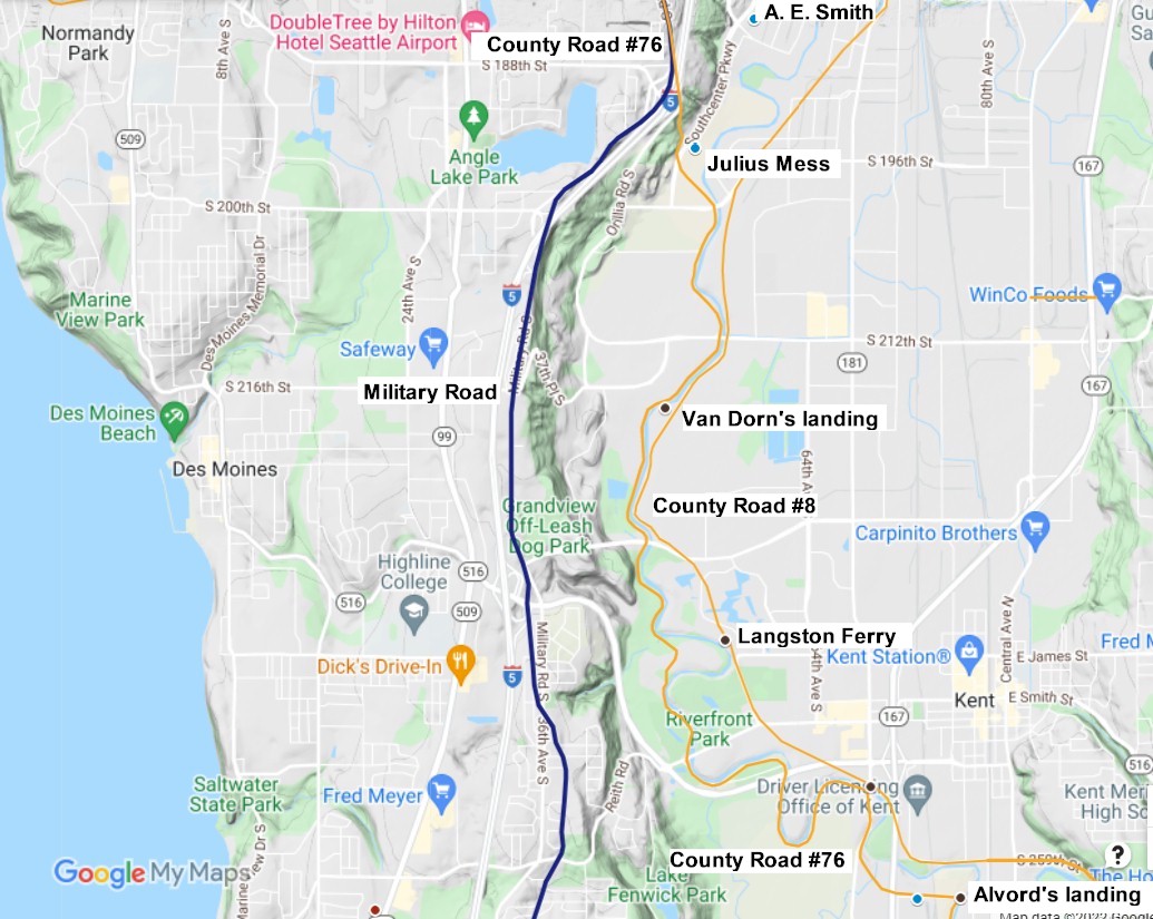
Kent area 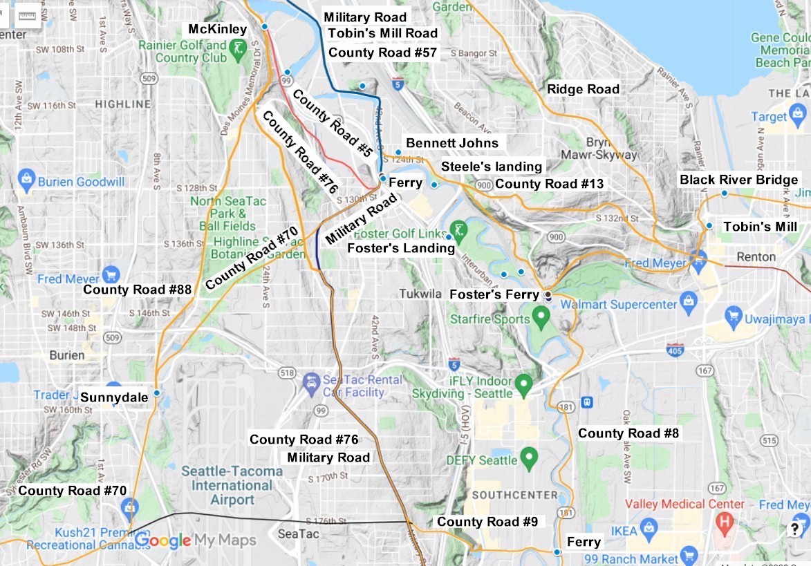
Renton Junction - Allentown 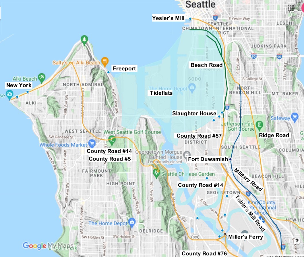
Seattle area |