![]()
The Historic Pacific Highway
in Washington
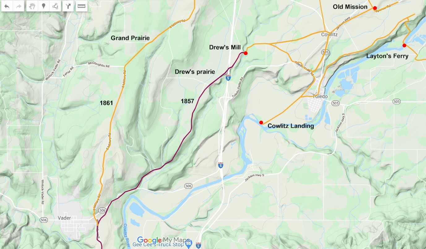
Drew's Mills
![]()
The Historic Pacific Highway
in Washington
Drew's Mills
History of Drew's Mills
By Curt Cunningham
In 1852, Captain George Drew and his wife Caroline, took a claim at the north end of a prairie that will take his name. Not long after he arrived, he built a cabin and a sawmill in a gully alongside a creek. Drew then turned his home into a general store and his place became the trading center for the residents of the surrounding area that was known as the Grand prairie. The ridge where Pike's Hill is located, runs in a north-south direction and splits the Grand Prairie into two parts. On the east side of the hill is Drew's prairie, which is located about 2.5 miles west of Toledo. On the west side of the hill is Banfan Prairie, which is located about a mile east of Winlock. Together they were known as the Grand Prairie.
That same year, Henry Miles arrived and took a claim on the prairie north of Drew. In 1853, Miles served as the first school superintendent for Lewis County. He also served as Justice of the Peace and was a member of the Democratic Central Committee. In 1867, after George had passed away, Henry married his widowed wife Caroline P. Drew, and they moved to Chehalis where he established a store.
Other early settlers of the Grand prairie were; John Sutherland, who had arrived in the area prior to 1850 and had taken a claim west of Drew. I am not sure if this was his first home or if he moved to the prairie sometime later. He filed his claim on March 6, 1866. In September of 1850, Edward Huggins of the (PSAC) met Sutherland along the road to Chehalis in a flipped over wagon that was deep in a mud hole. Sutherland was hauling bacon for John R. Jackson.
John Broulet, a retired Hudson's Bay employee had also taken a claim east of Drew, sometime in the late 1850's, and would sell his property to Michael Simmons in 1865. At the northern end of the Grand prairie in the mid to late 1850's was; John and Elizabeth Provost, Xavier Katman, Oliver and Catherine Donafina. In the 1860's, came John and Catherine Reille, and John and Ann Cantwell and Jonas Pike, who Pike's hill is named for
The donation land act of 1850 caused a great rush to the Oregon Territory, and by 1852, all the best land in the Willamette valley had already been claimed by earlier settlers. This made the Puget Sound region more attractive despite it being an expensive and dangerous journey to reach. By the fall of 1852, the Cowlitz river was busy with Cowlitz Boatmen taking settlers up the river to the landing. This method of travel was expensive and slow and those who were already established north of the Columbia wanted to get more emigrants to be able to come their way and the call began for a road to be built up the Cowlitz river to the Landing.
The V & S Military Road
In December of 1852, Fred Clark, who was the owner of Clark's Hotel at the Cowlitz Landing, started to distribute petitions asking the legislature to open a road from Monticello to the Landing. There was plenty of support from the current residents of Lewis and Thurston Counties as they all wanted more settlers to come north. Many emigrants coming over the Oregon Trail did not want to take another arduous journey up an unknown river in a canoe or they just couldn't afford to pay for the trip. It was very expensive to travel that way if you had a lot of stuff. Prices were around $40 per ton and it cost more to send the stuff up the river than the items were worth.
The petitions circulated for a few months and nothing else was done. During the spring of 1853, the Cowlitz river had swollen from the melting snow, which made it very difficult for canoes to move upstream. The flow of settlers that were coming up the river had slowed to a trickle. This proved the necessity for an overland route. That summer, volunteer crews began to clear a road to Pumphrey's Landing beginning at Drew's Mill. They cleared about a mile of road before they gave up.
In the summer of 1855, Lt. Derby sent Engineer George Gibbs to make a survey of a road from Fort Vancouver to Fort Steilacoom. After he finished his survey the war began, which delayed construction until after the hostilities ended a year later. This is when Lt. George Mendell under the direction of Colonel Walter W. DeLacy, began construction and by November of 1857, they managed to open a road from Fort Steilacoom to Drew's Mills. Here they ended work until the following summer.
The Territorial Democratic Convention
On January 10, 1857, a meeting of the Territorial Democratic Central Committee was held at the Washington Hotel in Olympia. Those present were; Colonel Edward C. Fitzhugh, of Bellingham Bay, Henry Miles of Lewis County, W. A. Strickler of King County and J. W. Wiley of Thurston county. Miles presented a letter from Seth Catlin of Cowlitz county who was not able to attend. The letter gave Miles authorization to cast Catlin's vote in the selection of the place for holding the next Territorial Convention.
After a thorough discussion, it was decided unanimously that the best place for the convention would be at Drew's Mills on May 11, 1857. The convention was for a nomination of a candidate for a delegate to Congress. The committee in Olympia had also decided that the ratio of representation at the Convention will be two delegates for each member of the House of Representatives.
The two day convention was called to order by J. W. Wiley the chairman of the Territorial Central Committee. On the first day, motions we entertained to create a credentials committee. After the committee examined the prospective members, they found them duly elected from their respective counties. On motion from Mr. Strong, the chair appointed a committee of five to give a report on the resolutions for the next day's meeting.
At 10am on Tuesday May 12, 1857, the convention resumed and the resolutions were read. Among the many that were read, was one that resolved to protest against the Hudson's Bay Company and their subsidiary the Puget Sound Agricultural company. These foreign corporations had no common interest with the American settlers, and that the welfare of the Territory was compromised. The last resolution read was to give thanks to Captain Drew and his amiable lady Caroline for the hospitality, kindness and attention bestowed on the members of the convention. Governor Isaac Stevens was then chosen as the delegate to Congress.
Drew's Mills
By 1857, Captain Drew had established a grist mill next to his sawmill and his place was known as Drew's Mills. In the 1864, Hand Book Almanac of the Pacific States, by William Knight on page 367, shows that the flour mill was operated by George Drew and the sawmill was operated by J. H. Miles.
During the spring and summer of 1858, Mendell hired George Drew and William James, who were experienced road makers and by the end of that summer, they had built 17 miles of road from the Cowlitz Landing over to Drew's Mills and then south over the toughest section of the road between Monticello and Steilacoom. The work ended at the Jackson Inn on Arkansas Creek.
Construction of the Military Road Resumes
After the work on those 17 miles was completed, the Military suspended the military road program, and the U.S. government used the remaining funds leftover from the previous construction, to build a pack trail from Arkansas creek to Monticello so supplies could get through. Nothing else would be done to the road until 1860, when congress approved $10,000 to be used for improvements between Monticello and Drew's Mills.
The Military tasked Captain Thom to complete the road, and after examining the route, found that between Fort Steilacoom and Drew's Mills the road was completed and in good order, and the first 6 miles of road leading north from Monticello was also in good order. The 17 miles between Drew's Mills and Arkansas Creek just needed some clearing of the fallen trees. It was the next 4 miles between the Jackson Inn and the Cowlitz river at Lexington that was going to take all the money he had. Captain Thom, knowing that he would need more funding had requested $40,000 more, but this request was denied. The only work that would be done in 1860, was a half a mile of corduroy over a swampy section south of the Jackson Inn. The work was done by George Drew and William Jackson.
The next spring before construction began to finish the last 4 miles of the road, Captain Thom decided to change the route from Pumphrey's Landing to go north along the ridge of Pike's hill to Katman's place. This new route would split off from the old road bypassing Drew's Mills. This fork in the road today is located near the intersection of SR 506 and the Westside Highway. This is about a mile east of Vader. This road still retains the name of Military Road. The older road to Drew's Mill would become a section of the telegraph line that ran between Portland and Victoria in the 1860's. This is why it is now called Telegraph Road.
Construction began in May of 1861 to finish the uncompleted parts of the road. There were numerous hills that still required heavy grading and ditching work that made construction slow and difficult. Between Drew's Mills and Lexington, 34 bridges and 5 miles of corduroy was built. On August 19, 1861, the road was finally completed and the next day, the first stage started out from Monticello toward Olympia. Even though the road was completed, it was by no means a good road. Those who have traveled it say it is the worst road they have ever been on.
The Grand Prairie in the 1860's
By the beginning of the 1860's, there were enough people living near the Grand prairie to petition for a post office. On July 25, 1861, the first post office was established and was called the Grand Prairie Post Office, located at Drew's Mills with George Drew as the postmaster. Drew was postmaster until 1864 when he sold his property and moved away from the area. On November 23, 1864, Joseph P. Menning was appointed the new postmaster, and the post office moved over to his place on the Grand prairie near Winlock.
In 1865, Michael T. Simmons moved to the Grand prairie from Tumwater and purchased some property that included a 2 room house from John Broulet. Simmons also purchased the now abandoned grist mill. Simmons rebuilt the mill and operated it until his passing in 1867. After Simmons death, the grist mill was sold to William Jackson from Arkansas Creek.
In 1865,
Wesley B. Gosnell moved from Olympia and built a home on the Grand prairie.
Gosnell would become a well known figure in the early territory and served
as a legislator and Indian Agent. Gosnell arrived in Olympia from Maryland
in 1851, where he married Catherine Cutting and they first lived together on the Squaxon Indian Reservation
that is northwest of Olympia. In 1862, Gosnell was living on Cutting’s
prairie, which is located near Napavine and in 1865, he
moved to the Olympia farm of William Winlock Miller, and the next year he
bought 640 acres on Drew’s prairie from Henry Miles.
Gosnell could speak several native dialects and was well liked by the Indians. As an Indian Agent,
during the Indian Wars, many officials felt the greatest obstacle to ceding Indian lands was Chief
Patakynum. Gosnell, who believed Chief Patakynum was misunderstood, wrote;
“His whole course was marked by a nobleness of mind that would have graced the General of a civilized nation, and that even though the Yakama Chief had waged war against the government, he never harmed the women and children of the settlers, or waylaid the lone traveler, but has been in many instances their protector.”
From 1885 to 1887, Gosnell served as a Lewis County Commissioner and was a member of the state legislature. When he served as the Justice of the Peace, he allowed the grooms who were unable to pay the marriage license fee, to work on his farm and earn enough money to purchase the license. Gosnell died of heart trouble at his home on the Grand prairie on April 4, 1896.
The Establishment of Winlock
The first settlers in the Winlock area was in 1870 when C.C. Pagget took a claim on the east side of the proposed railroad right-of-way and Jack Nealy took a claim on the west side of the proposed rail line. Pagget first arrived at the Cowlitz Landing in 1853 and opened up a store. In 1859, Pagget was teaching on the Squaxon Reservation and in 1863, he moved to Mason County. In 1867, he moved back to Toledo and bought his old place back from Javan Hall. He lived there until 1871, when he moved to the Grand prairie.
On December 27, 1873, Pagget filed a plot of land for a town that he named Winlock. Pagget was a good friend of Winlock Miller of Olympia and named the town after his eldest son. On August 19, 1873, Pagget was appointed the new postmaster of Grand prairie, and the office was moved to Pagget's home. The name of the post office was then changed to Winlock.
Winlock was incorporated in 1883, and by then only had 100 people living in the area. By 1886, only 13 city lots that had been sold. The town in 1886 had; 3 grocery stores, 3 blacksmith shops, 2 hotels, 1 drug store, 1 saloon, 1 hardware store, 1 general store, 1 meat market, 1 millinery store, 1 lawyer, 1 shoemaker and 1 doctor. Plus the old Drew's sawmill that began to operate again. There was no mention yet found of the fate of the old grist mill.
Winlock continued to prosper over the years and had a large agricultural area. From the 1920's to the 1950's Winlock was America's second largest egg producer. The world's largest egg resides in Winlock. It is 12 feet long and weighs about 1,200 pounds. The egg is located on the corner of Fir Street and SR 603 in Winlock.
John R, Jackson 1847-1872
Michael T. Simmons 1865-1868
Colonel Simmons Operated a Farm and Gristmill on Drew's Prairie
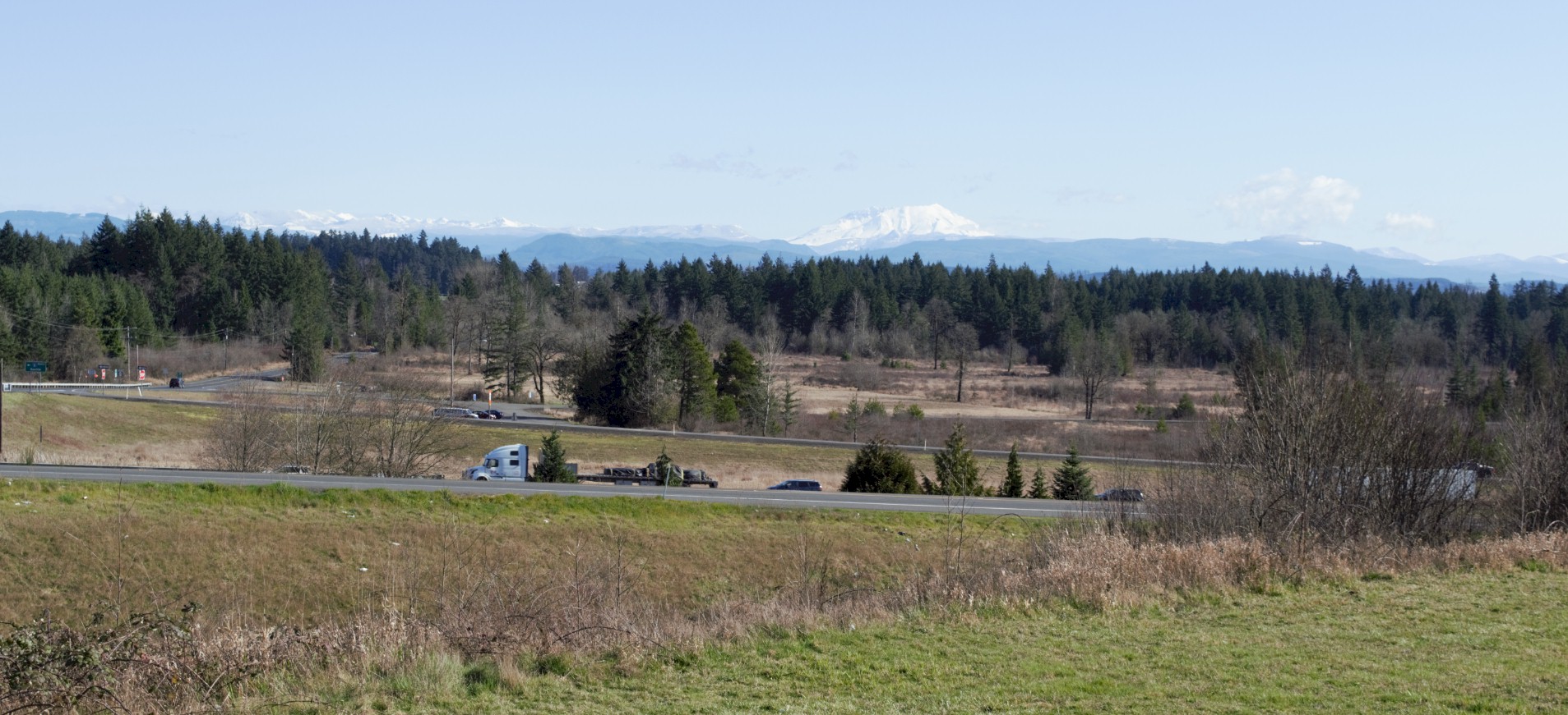
Looking east at the northern end of the Grand prairie. Mt. St. Helen's in the distance. Drew's Mills would be south of this photo.