![]()
The Historic Pacific Highway
in Washington
The Chuckanut Drive Landslides
![]()
The Historic Pacific Highway
in Washington
The Chuckanut Drive Landslides
The Chuckanut Drive Landslides
By Curt Cunningham
Much of Chuckanut Drive was built along the side of a mountain and a ledge had to be blasted out of the rock for the roadway. There are 4 viaducts which were built at places were it was too narrow to build the road. Building on the side of a cliff was a great challenge for the engineers. Roads along the sides of mountains are prone to slides and cave-ins. Chuckanut Drive was no exception and over the years there were many slides that blocked the road. One such slide caused a giant boulder to roll down the hill and come to rest in the middle of the road blocking the path. The rock was so large it had to be blasted with dynamite before it could be moved.
The 1930 Slide
On Thursday evening March 27, 1930 rocks and trees crashed down onto Chuckanut Drive blocking the road. This was the second slide within a week and it was estimated that more than 200 tons of debris came hurling down. This slide occurred near the Whatcom-Skagit county line and it was one of the heaviest slides of the past 2 years. The pavement escaped injury and the highway was reopened to traffic by Saturday morning March 29th. While the slide was being removed by a crew under direction of E. C. Baxter, state highway supervisor, all bus and other heavy traffic had to be routed over the Wickersham-Lake Whatcom highway, as the Lake Samish road was impracticable for heavy loads.
The 1937 Slide
Another slide happened on November 29, 1937 when an avalanche of rock and earth came crashing down on Chuckanut Drive and the Great Northern's Seattle - Vancouver right-of-way. Telephone service north to Vancouver, B. C, was disrupted by the slide. Great Northern railroad section hands, Pacific Telephone & Telegraph company linemen and state highway department crews worked during the night to repair the damage. The slide covered about 150 feet of the railroad's tracks below the roadway with rock and earth, and railroad passengers were transferred to busses at Burlington and Bellingham.
Telephone service was restored that evening and the railroad was opened for traffic the next day. Highway department officials. however, said the drive, one of the 2 main arteries from the north, would not be open to traffic for at least a couple of days.
The slide, was about 10 miles south of Bellingham and it almost cost the lives of J. M. Whelan and Gerhard Larson, who were members of the state highway maintenance patrol. Whelan, who was in a state truck, had just driven past the point when he heard the shock and looked back to see the slide crashing down on the road. Larson, whom he had just passed, escaped on the other side. The avalanche blocked off 150 feet of the highway and took out a portion of the road. The slide also destroyed a section of retaining wall.
The slide may not have been repaired in a couple of days as was hoped for or another slide occurred a week later. This is because on December 5, 1937 Viola Randall wrote; "Did the usual Sunday morning custom. Read the funny papers in bed. Got up at noon again. Had breakfast and then the three of us drove out to the landslide on Chuckanut Drive and took some pictures of it. Came back to the hotel and left Val off and then Eddie and I took another drive. Later had a grand dinner and then saw another double feature. That's 14 shows I saw in seven days. Ate a sundae at Smalley's, came back to the hotel and went to bed."
Viola along with her husband Edward Randall and Valentine Martins were on a trip around the country selling photos and yearbooks to members of Civilian Conservation Corps (CCC) camps and Bellingham was their northwestern most stop.
From looking at Viola's photos which were sent in by her grandson Dave Randall on August 4, 2023, it appears that this slide occurred on Viaduct #2, according to Jeff Fox who was able to pinpoint the spot. Jeff said that; "the location of this slide is easy to I'd. In Viola's photo, the concrete railing (Concrete Railing #1) is a retaining wall, just ahead is a small outcrop where heavy construction wasn't necessary. Just ahead is the viaduct that I call Viaduct #2. Just past Viaduct #2 is a zag in the road."
"Being that rail #1 also has a slight turn at the end, and the bank is steeper there. I'll bet my dollar that the slide was on Viaduct #2. You will also notice the telephone poles are very close to the road. At Seawood Cliff, the poles were well below the highway so this rules out that area. Concrete Rails in the slide area and Seawood Cliff were identical. Seawood's rails were replaced about 20 years ago or so. The other set of concrete rails where the road caved in had the rectangle pattern."
The 1974 and 1976 Slides
In the spring of 1974 a section of Chuckanut Drive just south of Clayton Beach began to settle which created giant cracks in the pavement. The road in this section was narrow leaving a shoulder along the cliff about 12 inches wide. On March 19, 1974 the 3.5 mile section of Chuckanut Drive from Oyster creek to Larrabee park was closed and the State Highway Dept. began to remove the damaged pavement to make repairs. After the pavement was removed and the rock was exposed, anchors were driven in hopes to prevent the road from collapsing further.
This fix would only last for 2 years.
On January 28, 1976 Chuckanut Drive was closed between Larrabee park and Oyster creek. This was when the previous slide back in 1974 began to settle again. This time it had undermined the cliff-side and the road was in danger of collapsing. Then on May 15, 1976 the road finally gave way and the section which was repaired back in 1974 collapsed and fell down the mountain.
Jeff Fox who grew up near Chuckanut Drive said that; "because the geology here was pre-mature shale rock and sandstone there was a prerequisite requirement of education from geologists on behalf of the engineers which was required before attempting any type of repair. There was even talk of abandoning the highway completely. Finally a solution was found and presentations to the highway dept. were made. The repair would consist of many anchor bolts and a heavy duty retaining wall. The last time I drove the road before the dive down the hill, the fog line was only one foot from the edge and there were some metal white stakes standing right next to the fog line. Thank God no one ever drove off the edge."
"On May 23, 1976 I packed my Kodak 828 and headed off to Chuckanut Drive to view the location of the road failure. Just as I thought it was located exactly where I predicted it would be. This small section of highway over the years lost its shoulder on the cliff-side to where finally the fog line and temporary metal markers were only inches from the drop-off. Below is a photo showing what this area looked like on May 23rd. The vintage photo is a 1930's post card showing the exact same spot."
"At this location there are two sections of heavy concrete walls, a viaduct, and concrete railings. There was also a section located between the heavy construction areas, though that at the time of construction did not require any work as there was ample land and the wood guardrail would suffice. The vintage post card photo was taken by either Elias Breidford, or his father. Elias was a professional photographer in Blaine, WA. and for many years in the late 1950's to early 1970's was the director of the Bellingham Male Chorus. He had a beautiful tenor voice and I spent many years as the chorus' accompanist."
"Also of interest in the vintage photo are the telephone poles. Later in the 1950's these poles supported only two cross arms. When the wires were no longer needed, they were taken down, salvaged and the poles were simply cut at the base and toppled. After the 1967 forest fire in the area I managed to save a few of the insulators and I still have a few of these sitting in my window."
On May 24, 1976 construction began to repair the cave-in. The Tripp Construction Company of Renton, Washington was awarded a $178,626 emergency contract by the State Highway Dept. State engineer W. C. Bogart said the contractor believes they could finish the work by mid August. “Construction will be both difficult and delicate,” Bogart said, ‘‘because of the topography at the site and the fact that the Burlington Northern main-line tracks are below and must be protected.”
Plans called for construction of a concrete retaining wall about 250 feet long and varying in height to a maximum of 24 feet. The wall was poured in 20-foot-long panels, with each panel anchored into the rock cliff by 4 steel tie-bars. When the wall was in place, about 1,800 cubic yards of fill material was placed behind it and the roadway was rebuilt on top the fill. The new retaining wall matches the adjoining sections of the original retaining wall along the narrow highway. The new road had shoulders 24 inches wide on each side with an 18 foot wide roadway. The contractor was not able to finish the work by mid August and the highway was reopened in October of 1976.
I wish to thank Jeff Fox and Dave Randall who contributed their stories and photos which helped in the creation of this web-page.
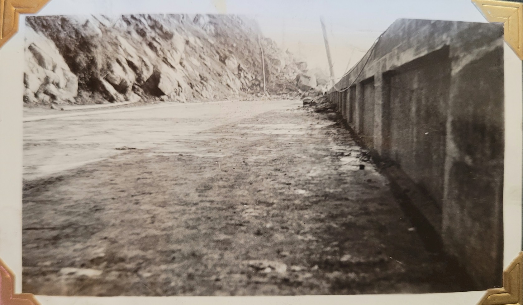
Photo showing the 1937 slide. 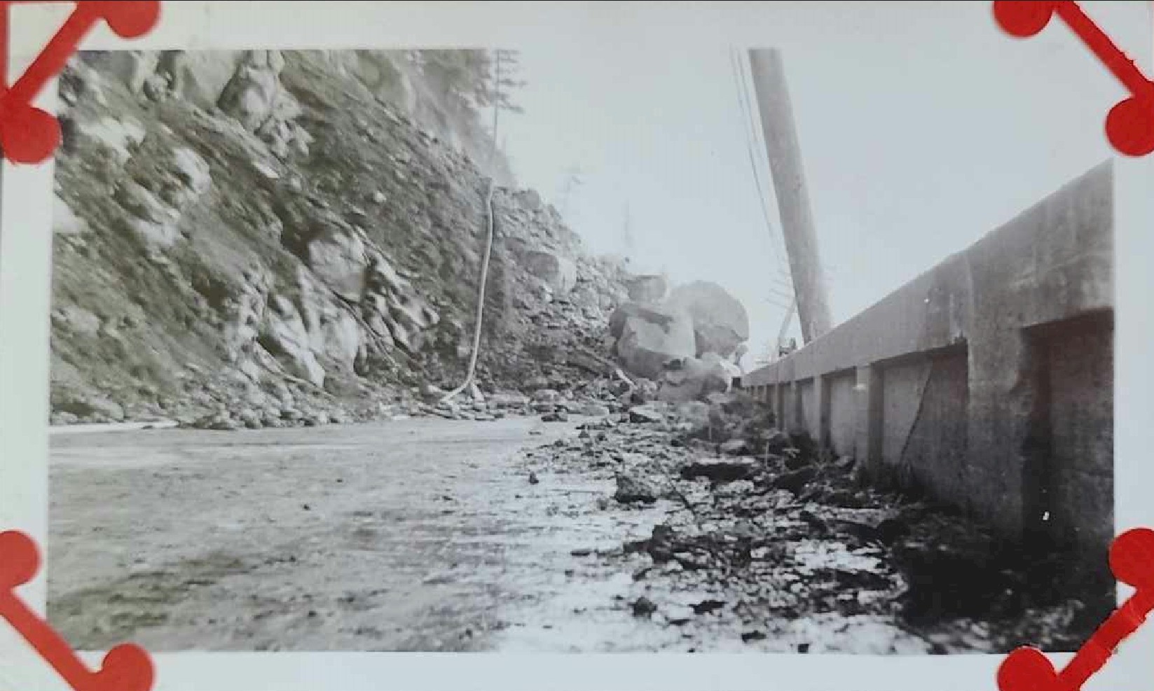
Photo showing the 1937 slide.
You can see a previous repair on the retaining wall. 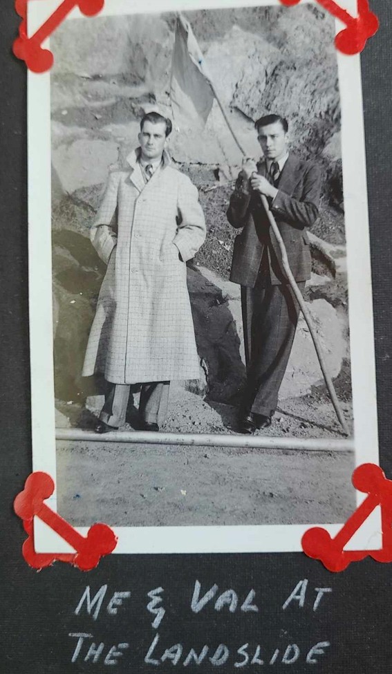
Photo of Edward
Randall (left) and Valentine Martins (right) at the 1937 slide. 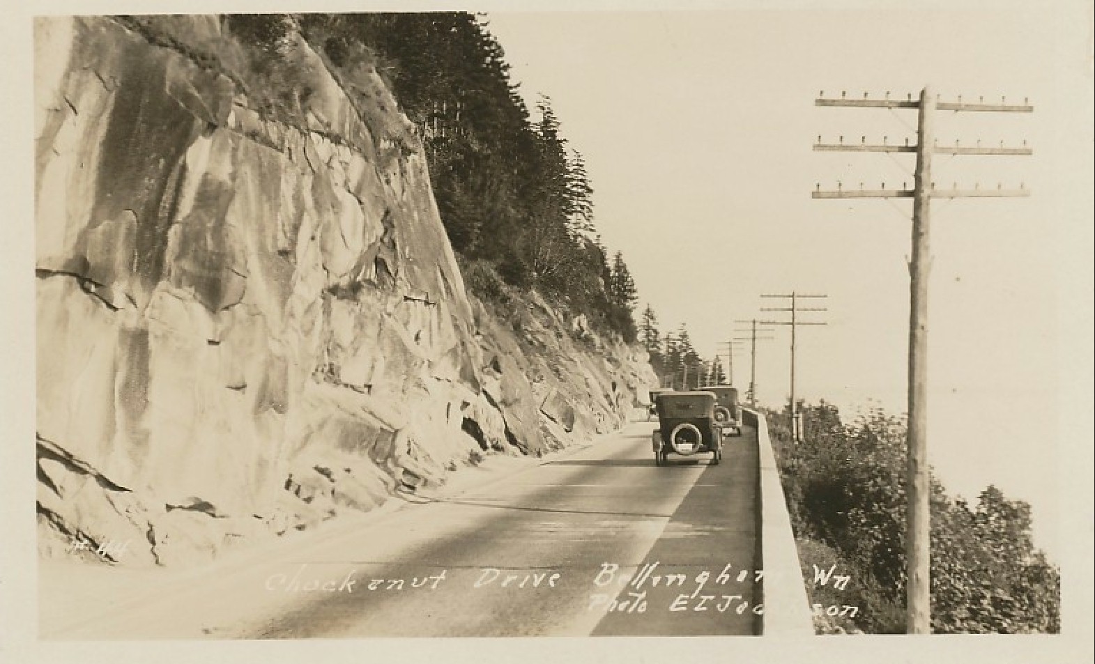
Location of the 1937 rock
slide. You can see where the the new retaining wall meets the original
wall. |
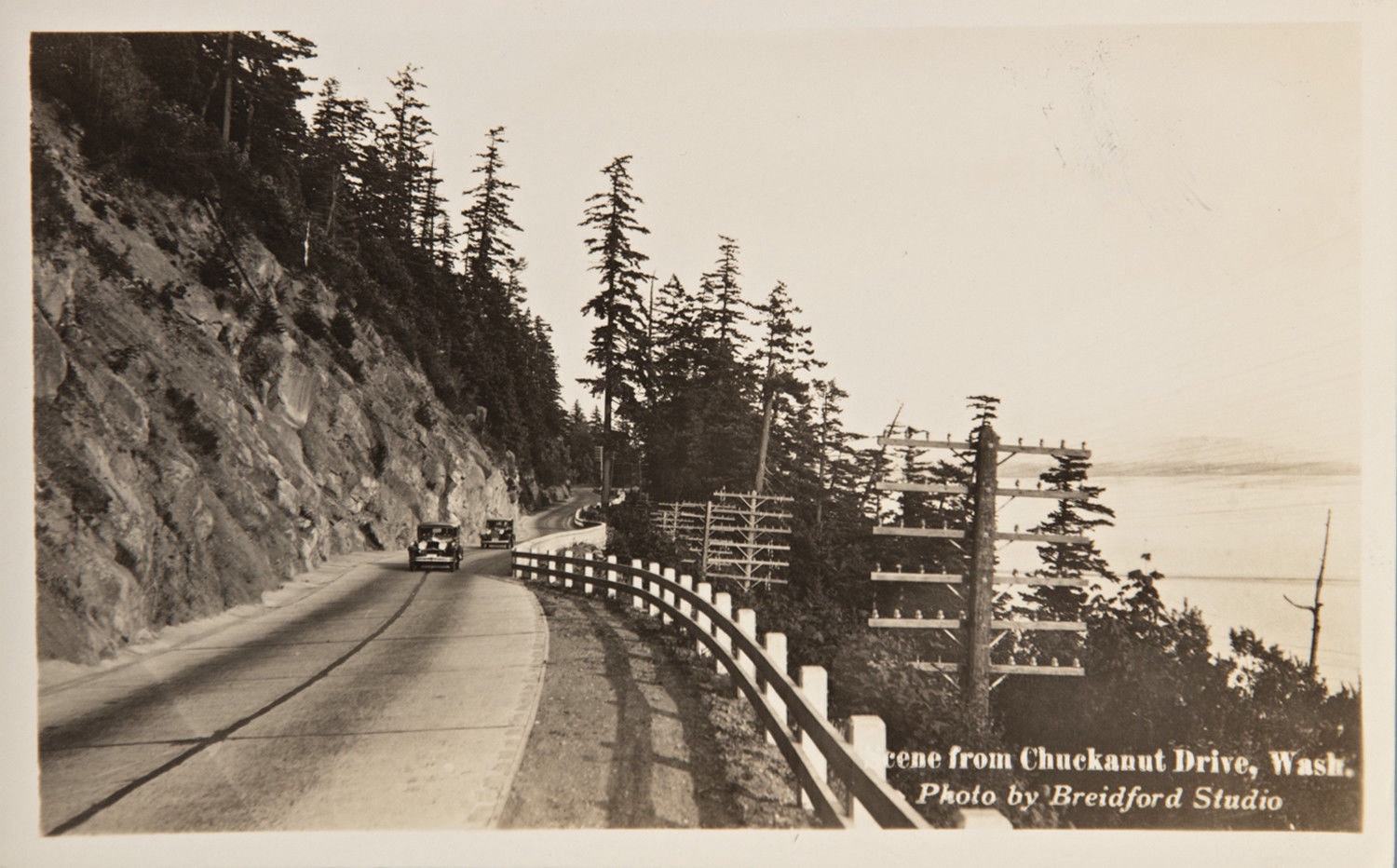
1930's Elias Postcard
showing the place where the road collapsed. 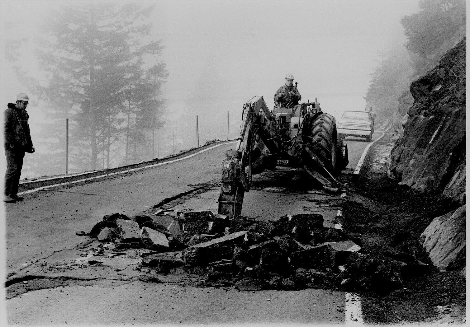
1974 repair work. 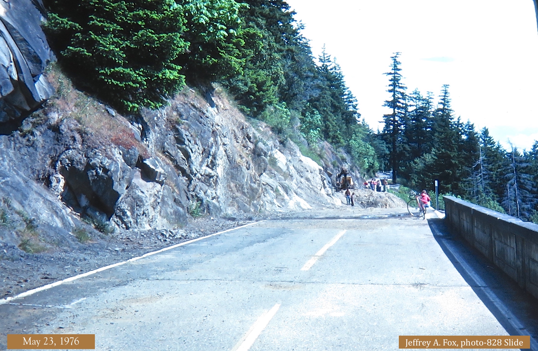
May 23, 1976 before the
repair work began. 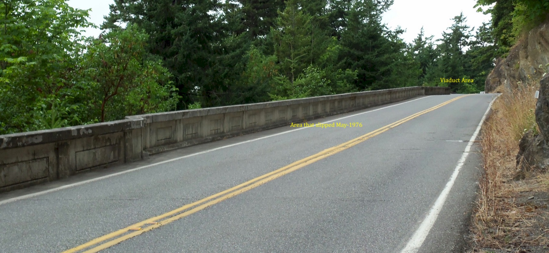
2011 Photo of where the
road fell. You can see where the the new retaining wall meets the original
wall. |
©2011-2023 pacific-hwy.net
All Rights Reserved