![]()
The Historic Pacific Highway
in Washington
La Center Hill
![]()
The Historic Pacific Highway
in Washington
La Center Hill
La Center Hill
By Curt Cunningham
Across the East Fork of the Lewis River on the south side of La Center, was the notorious La Center Hill. The wagon road, constructed in 1878, came down this hill from Pioneer to the river crossing. Before the first bridge across the East Fork was built in 1883, the county put a free ferry in at the crossing. It was said that the citizens of La Center showed their appreciation by letting the ferry float off at the first high water.
The wagon road down La Center Hill was on the opposite side of the small canyon from the "S" curves and was a part of the road to Ridgefield and Vancouver. This was the road the teamsters used to get supplies into town when the river was too low for the steamers. The wagon road between Ridgefield and La Center was one of the busiest roads in Clark County during that time.
Crabb's Corner to La Center
The village of Pioneer is located 13 miles north of Vancouver and 4 miles east of Ridgefield. Pioneer is a farming community that began in the late 1860's. The post office at Pioneer was established in 1874. Before the wagon road was extended north from Salmon Creek, the Ridgefield Road was the route the farmers from La Center used to take their produce to the steamers waiting at Shobert's landing. This of course was when the steamers could not reach La Center during the dry summer months.
In 1869, the wagon road from Salmon Creek was extended to Ridgefield. At Baker, which is now the intersection of NE 10th Avenue and NE 179th Street, the old road veered to the left and traveled in a NW direction to Ridgefield. Around 1874 at Baker, the wagon road was extended north to Pioneer to connect with the Ridgefield Road. This corner will become known as Crabb's Corner. In 1878, the wagon road to La Center was completed. The road was extended north from the intersection of Pioneer Street and N. 65th Avenue. This road ran north to the Gerow bridge that used to span McCormick Creek. This road was used as the detour during the Pacific Highway construction.
Crabb's Corner is located at the intersection of the old Pacific Highway and S. 5th Street in the village of Pioneer. Crabb's Corner was named after Stephen and Margaret A. Crabb. The Crabb's were early residents of Pioneer. Stephen Crabb was born in 1832 and passed away in 1918 and is buried in the Pioneer Cemetery.
The Baker community was named after Henry Baker who had a farm near 179th Street and NE 11th Avenue. Soon a settlement took root and it became known as “String Town.” the name came from the residences that were strung along the highway. After Henry donated land for a school the area was named after him. His son George Baker established a large logging camp there and had taken all the availble timber and closed down in 1911.
Traveling from Vancouver
In 1913, the state planned to realign, grade and surface the Pacific Highway between Pioneer and La Center. By 1915 the highway had not yet been graded. The reason was that the state was having difficulty in securing the property at the places needed for the new right-of-way between Salmon creek and La Center.
On March 20, 1915, R. B. Gillis, state locating engineer along with the Clark county engineer, made a survey of the new right-of-way between Salmon creek and La Center. The state wanted an estimate of the cost to pave the roadway with macadam. Condemnation proceedings were made in several places along the new route to obtain the right-of-way, though it would take 3 more years for the state to actually gain possession of the properties and finish the grading of the highway on the 3.62 mile section between Pioneer and La Center.
On March 21, 1915, O. B. Aagaard, a prominent businessman of La Center, who also was county commissioner and representative in the Legislature, advocated the use of the split-log drag on the roads. He wanted the farmers to use the Swedish method of compulsory road maintenance, where each person owning property along the road being held responsible for their portion being kept in good shape. Mr. Aagaard said it would be a profitable investment for the county to buy or make split-log drags for the farmers throughout the county and to see that they would be used when the road was in the right condition. He and a neighbor the previous year, used drags on the roads running through their farms, and it worked so well that the road was known as "La Center Boulevard."
On April 16, 1916, Arthur Finley declared that; "More signs are needed on the Pacific Highway between Portland and Seattle." This was his first comment after he returned from a trip to the Sound from Portland. Finley had made it as far as Clark county over roads that were none too well marked. Near La Center he followed the obvious direction and plowed along over a muddy road that got worse and worse.
Finally he came to a stop, and the journey seemed doomed to a
dismal and damp end in a cold drizzling rain. The farmer that was watching
the car get stuck
came to rescue the adventuresome motorists with a horse and a lantern. Chains finally were put on the car
for the first time during the trip. They were then able to reach the main road.
The farmer said that the road which Finley had followed was the road formally in use,
but that the Pacific Highway routing should show the road turning to the left just
south of La Center.
The signs hadn't been changed and the mud hole road seemed to be the accepted road,
even after the
change in routing was made and the automobiles just continued to take the wrong road, according to the obliging
farmer who pulled their car out of the mud. However, Finley said that "over the whole route much work had been done since the roads were last opened to tourist travel." The
spirit of better roads had all the counties doing their best to put their
section in fair shape before
summer touring season.
On April 15, 1917, the state was preparing to grade and gravel the new section of the Pacific Highway between Pioneer and La Center. This 4 mile stretch was now the only unimproved part of the highway in Clark County. This part of the road was impassable at the time and a short detour was necessary The new grade down La Center Hill will be 6% which was the maximum grade allowed by the state.
On August 16, 1917, Chester A. Moores wrote about a drive he took with H. H. Eling, the manager of the Portland branch of the Overland Pacific Company. They took a 3 day trip in a four cylinder Willys-Knight car through the mud and slush which marked much of the way from Portland as they traveled to; Mt. Rainier National Park, Seattle, Tacoma, Fort Lewis and returned to Portland, for a total distance of nearly 550 miles.
This is what he said about the road into La Center from Vancouver; "By the time Vancouver had been reached via the Broadway bridge. East Broadway and Union avenue, and the 6.5 miles of pavement leading out of Vancouver had been covered, the trip speedometer registered 14.8 miles. From the end of the pavement to the town of La Center, the road was fairly good and solid despite its wetness, except the notorious hill this side of La Center, which is apt to obstruct travel during bad weather. One machine had been stranded on this hill the night before our arrival and chains were positively needed by all cars. It is understood that the improvement of this hill is to be commenced in the near future, but it can hardly be reclaimed entirely before the next touring season."
On November 11, 1917, Joe H. Jordan took a trip to Seattle from Portland and said that; "8.5 miles of fairly good gravel road intervene before taking the first bad stretch. This consists of about a mile and one half of slow, muddy road, a rather steep pitch into a ravine and the descent down the La Center hill. Contracts have been let for the construction of a new road to eliminate this detour, which is to be ready some time next summer. After crossing the East Fork of the Lewis River at La Center the road is in good shape to Woodland."
On October 13, 1917, the state highway department had completed purchasing the right-of-way between Pioneer and La Center. The route of the new road was to be on the opposite side of the canyon from the present road. The Gerow bridge on the present detour route was reconstructed and elevated 6 feet reducing the steep grade at each end of the bridge. The bridge was 230 feet long. The Gerow bridge used to cross McCormick creek on what is now called NW Spencer Road.
Finally on January 28, 1918, the plans were approved so the construction of the new highway between Pioneer and La Center could begin. This project, 3.6 miles in length, covered the last unimproved section between Vancouver and La Center, and was constructed as a Federal Aid Post Road Project as 3.2 miles of the road was covered by a mall route. Bids for clearing and grading the section were opened on October 1, 1917, and the contract was awarded to Arvid Rydstrom of Tacoma for $45,103.70. The roadway was built 30 feet wide in the cuts, with a 28 foot width on embankments.
On February 3, 1918, Lair H. Gregory said this about the road from Vancouver to La Center; "From Portland to the end of the Pacific Highway pavement is 14 miles. From that point to Kalama the highway is nothing for any man to brag about. In fact, taking it by and large, it is by long odds the worst section of the whole highway from Portland to Seattle. This is due partly to the fact that a detour must be taken nearly into La Center and partly to the fact that much of the main highway beyond La Center and to the other aide of Martin's Bluff is not greatly better than this detour road."
"The detour is for the most part plain mud and deep mud, made worse by the fact that it has been cut up by heavy team hauling. The mud comes to the hub of a car and over. More than half an hour of the two hours difference between running time and elapsed time for the trip was devoted to trying to make chains fit the oversize cord tires on the rear wheels just before the plunge was taken into the mud of this detour road."
"The handy Knox finally solved the problem by hooking the ends of the chains together with wire filched from a nearby barbed wire fence--the barbs, of course, being twisted off before the chain was wired. Much has been said by motorists of the perils of the La Center Hill which was not as bad as they painted it. While muddy and slippery, it was not too difficult, provided chains are used."
On June 2, 1918, after crossing the bad detour and ascending the grade on the other side, which was also rather rough, the motorist was brought again onto the Pacific Highway, which continued down the hill to La Center. This was the worst part of the trip and care was needed in making this descent. It was painfully rough in places, steep and narrow, where teams and autos passed each other with great difficulty. Construction work was in progress building the new grade on the other side of the canyon leading down to the town.
Before reaching the detour, there was a large red sign across the road which said the highway was closed. The sign pointed the driver to the left over the detour and in about a half mile or so another sign pointed to the right toward La Center. This stretch was somewhat rough, and it was abandoned after the construction was completed. The new grade required considerable excavating and months of hard labor. After it was completed, the road wound gradually down into this pretty little town, ending with a graceful "figure 8" at the bridge which crosses the Lewis River.
During the summer of 1918, the road was now tore up making it difficult for cars to get through. Drivers going between Portland and the Puget Sound were advised to take the Kalama-Goble ferry to avoid the mess. On August 25, 1918, a motorist had this to say about the construction work going between Pioneer and Woodland;
"The motorist bound for Tacoma or Seattle who tries to drive down the Washington side of the Pacific Highway via Vancouver to Kalama on a wet day is out of luck. He probably will be able to get through, but he will have an uncomfortable time doing it, and will make the abundant acquaintance of that old college chum Washington mud. Also, he will get the shaking up of his life, for this road on the Washington side is now for miles in the throes of construction work and is thoroughly bad."
"During the rain last Sunday cars
were scattered along at various places between the La Center Hill and Kalama.
At one point 9 automobiles were held up by a car ahead that was stuck in the clay. It was not badly wallowed, but the clay was just slippery
enough so that the rear wheels spun around every rime the driver applied the power, and he had neglected
to bring his chains along with him."
"He was finally lifted out of the mire by the husky shoving of half a dozen
other motorists. Each succeeding car likewise was boosted over the incline. However, the water runs off this clay
amazingly fast. This same road that was so sticky Sunday was packed and baked on Tuesday, without a vestige
of mud. But it was very, very rough and there was a construction track for cars to climb up and over.
Taking it all in all, any good driver can go on from Vancouver to Kalama on a dry day without running
any risks, though he will be well shaken up, no matter how many shock absorbers he carries. But on a, wet
day......"
There was construction work along this part of the Pacific Highway just this side of La Center, where road crews and a steam shovel were slowly cutting out a new grade that will eliminate the La Center hill. But the new grade was not yet completed and on the portions where cars were routed over it, the least amount of rain made it a slippery mess.
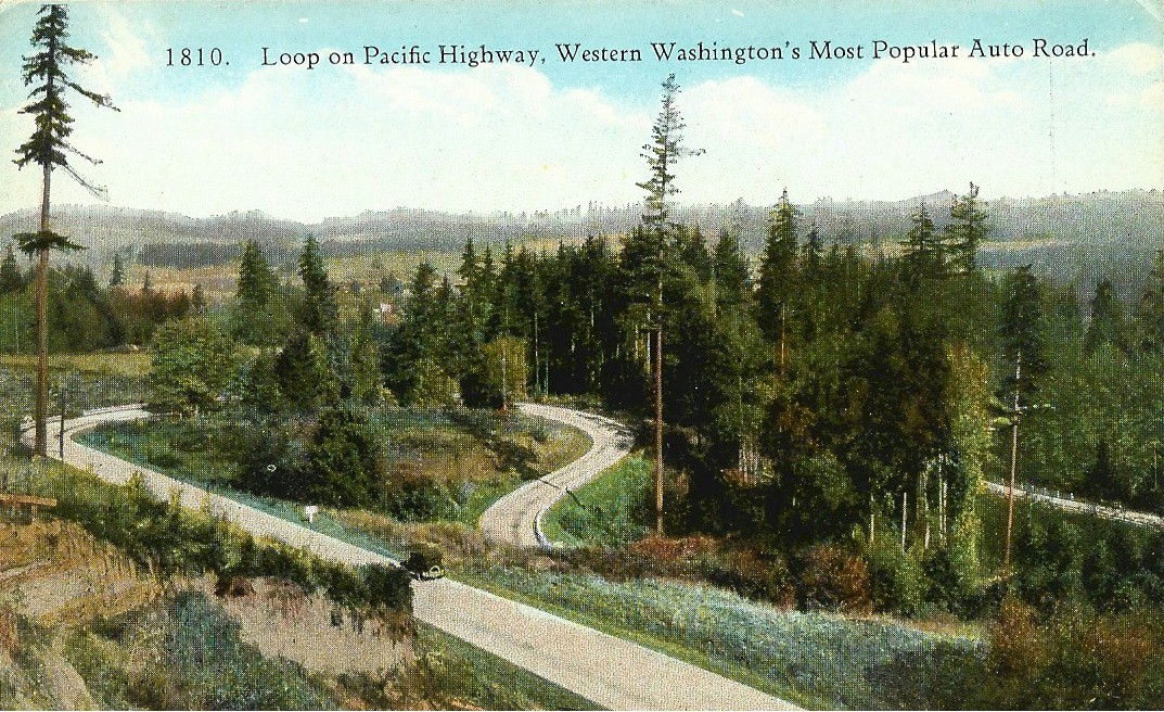
The new grading work on the "S" curve was completed in October of 1918 and opened for traffic. The gravelling of this section was completed by the D. A. Williams Co. of Tacoma on August 10, 1919. This new grade eliminated the steep and slippery La Center Hill.
On March 21, 1920, the road down La Center Hill was now a good road and a motorist had this to say about the new grade; "As the car nears the brow of the hill above La Center, the road changes some what in appearance, the new road is a trifle smoother. There is a real "S" curve that one lakes down the hill toward the town, probably one of the best figures of that sort to be found on the highways in this, part of the country."
"The engineer ran true to form, and the curves are well constructed and the grade is easy, with the surface of a sort that may be subject to argument on both sides as to its smoothness. The long bridge into the town is next reached, and the car runs past the old shingle mill on the right, and over the stream on the left is the good ship La Center, at anchor. This boat is nearly wide enough to fill the stream, or else the stream is of such narrowness as to to almost be filled by the craft. Visitors may say one thing, the natives of the place another."
On October 2, 1921, W. H. Lyman along with Harry Hays, made the run northward from Vancouver to Kalama over the new pavement so they could find out about the condition of the road that was beyond the end of the pavement at La Center. They also wanted to know the locations of the construction that was still in progress. The run was made in a comfortable little Overland sedan, and it was a delightful trip from start to finish. The new pavement, that was just completed that year from Pioneer to La Center, followed the general specifications of the other permanent highways of Washington, being of concrete, 20 feet in width and widened to 24 feet on the curves.
The entire section through which the old highway passes through is of an attractive character, rich farms and orchards interspersed with small tracts of wooded land. The last mile, in which the road dips down into the Lewis River valley and on to the Lewis River bridge is not easily surpassed in beauty.
The concrete paving between Pioneer and Woodland began in the summer of 1921, and was officially completed on September 14, 1921.
Today, NW Lacenter Rd. connects the freeway with the town and the old highway has been cutoff at the bottom of La Center Hill on what is now called NW Pollock Road. This small section of the old highway still retains its 1921 pavement. From this part of the old highway you can view the beautiful scenery of the bottom lands of the East Fork. All the original concrete guard rail posts remain, and at the bottom of the hill these posts are maintained with a fresh coat of white paint. Pioneer John Pollock's gravesite can also be found at the bottom of the hill.
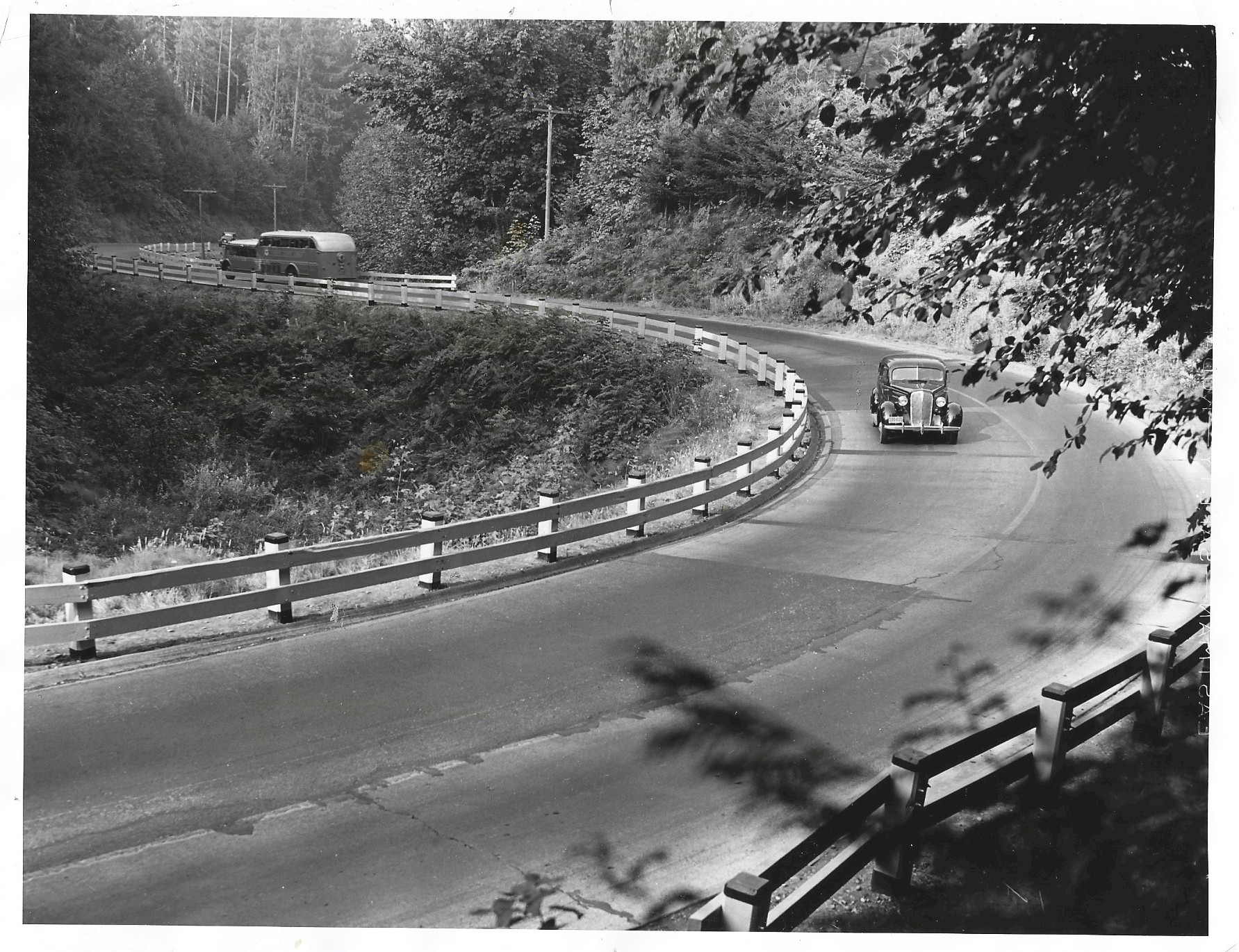
August 27, 1939 Press photo.
Caption reads; Curves like these have been "cussed" and 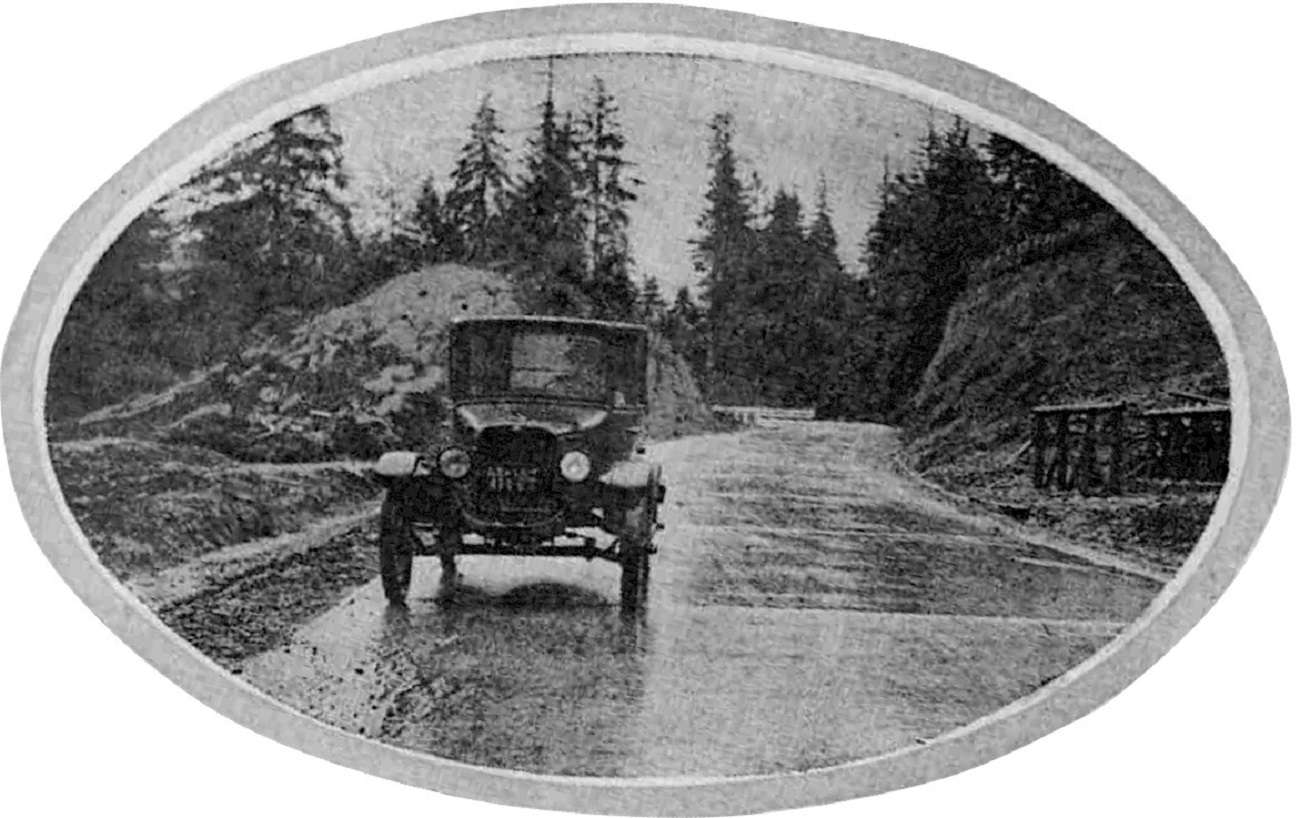
1921 La Center Hill 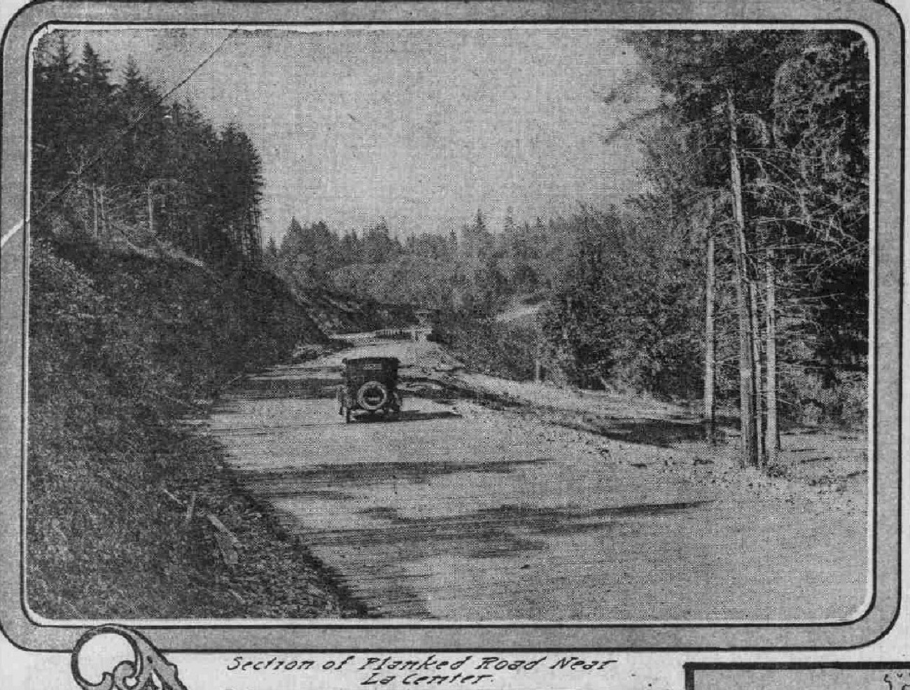
1922 finished highway northbound. 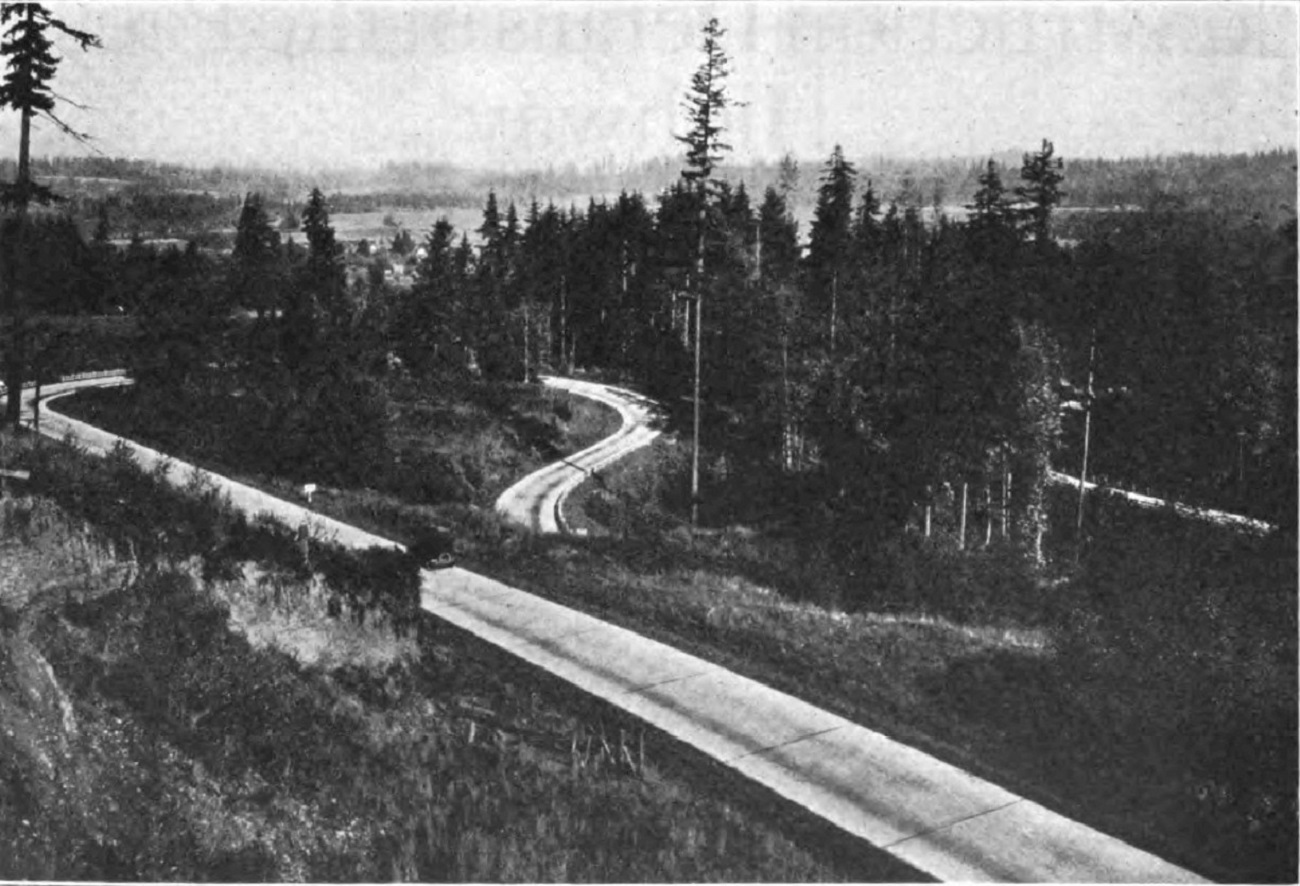
1923 Looking north |
©2011-2022 pacific-hwy.net
All Rights Reserved