![]()
The Historic Pacific Highway
in Washington
Early Roads to Everett 1864 - 1909
![]()
The Historic Pacific Highway
in Washington
Early Roads to Everett 1864 - 1909
History of the Roads from
Seattle to Everett
By Curt Cunningham
The Fort Steilacoom - Fort Bellingham Military Road
The first wagon road to reach Snohomish county from the south was the Fort Steilacoom - Fort Bellingham Military road which was constructed in 1860. The road began at Fort Steilacoom and traveled the existing wagon roads to Yesler's Wharf in Seattle. From Seattle the road continued northeast over the east side of Queen Anne hill to Fremont. After crossing the creek at the west end of Lake Union the road continued north along Phinney Ridge to the Washelli cemetery where it turned northeast to the bluff overlooking Lake Washington near the Acacia cemetery, which is about a mile southeast of Briarcrest.
From here the road turned northwest toward Lake Ballinger, and passing it .75 miles to the east, the road then continued north through Mountlake Terrace to Martha lake. From Martha lake the road turned east around the north end of the lake to 164th St. SE in Mill Creek, and continued east to Fiddler's Bluff. Fiddler's Bluff is located on the south side of the valley opposite the town of Snohomish about 2 miles north of Cathcart. After going down the hill, the road traveled across the valley to the ferry crossing in Snohomish. In 1878 the Military Road between Fremont and the King-Snohomish county line would become County Road #78 or the W. L. Weedin road.
The Telegraph
In 1864 a telegraph line was strung between San Franand New Westminster, Canada. The wire was hung on poles which were placed alongside the military road from Vancouver, Washington to Alderwood Manor. At Alderwood Manor the telegraph line split off and turned northwest where it followed a trail to the station at Mukilteo. This trail is now known as State Route 525. After reaching Mukilteo the line continued north along the beach (Mukilteo Blvd.) to the station at Everett, which was then a village along the shore called Port Gardner. The telegraph office at Port Gardner was located near the shore just south of Hewitt St. in Everett.
The line then continued along the beach, and crossed the Snohomish river at its mouth, and continued northwest between Lake Goodwin and Lake Howard to the next telegraph office which was at Port Susan. Thomas Adams was the operator there. In 1865 B. C. Shorey became Mukilteo's first telegraph operator. Shorey was the operator for about 10 years when he retired from his post and Erskine D. Kromer took over. Kromer had arrived in the area in the 1860's to help install the telegraph line.
The Snohomish-Lowell Road
In the 1860's Snohomish, Lowell and Mukilteo were the principal towns in Snohomish county. Mukilteo was originally the county seat and the mail for Snohomish was dropped off there by boat. The postmaster then sent it to Snohomish by anyone who happened to be going that way. There was a trail which ran between Mukilteo, Lowell, and Snohomish. The Snohomish county seat was moved to Snohomish City in 1861, and the mail would be brought up the river by steamer. In the early days the town of Snohomish was called Snohomish City. By the 1890's Everett became the largest town in the county and the county seat would be moved there in 1897.
The town of Lowell predates Everett by about thirty years, and began in 1863 as a single log cabin which was used by the Smith, Wilson & Company as their logging camp. Lowell was a small town along the Snohomish river less than two miles south of Hewitt Ave. in Everett. In the 1960's Lowell was annexed to the City of Everett.
The first road between Snohomish and Lowell began as the trail which ran along the foot of the bluff on the south side of the valley. This was also the trail to Mukilteo, and by the late 1870's between Snohomish and Lowell the trail would evolve into a wagon road. On February 17, 1877 surveyor L. T. Ireland was paid out of the general road fund for the survey of the county road running from Lowell to Fiddler's Bluff. The following paragraph written in 1877 is about a trip made down this county road from Lowell to Fiddler's Bluff.
On August 4, 1877 The Northern Star ran an article about the three large marshes in the Snohomish river valley. One of these was called the "Big Marsh" and it was located between Lowell and Fiddler's Bluff. Beginning at Lowell the writer began his journey and the first place he arrived was the farm of Amos Hurst.
Hurst lived about 1.75 miles east of Lowell, and he had homesteaded there in 1870. By 1877 he had cleared 30 acres of land. After a visit with Hurst the writer came to Mr. Beard's farm who also had about 30 acres cleared, and he had been there about as long as Hurst. After Beard's place was Mr. Stevenson's farm who had been there just as long as the others. His farm was about 2.5 miles west of Fiddler's bluff where he had about 30 acres cleared. All these farms enjoyed crystal clear water which runs out of the bluff ice cold, and the springs are above the high water mark of the river.
The Snohomish-Lowell road was graded in 1884 the same year Lowell was platted. In the 1890's the road was extended northwest to Everett, and today it is known as the Lowell-Larimer road. Sometime in the late 1880's or early 1890's another road was constructed along the south side of the Snohomish river to Lowell. Today this road is called the Lowell-Snohomish River road.
Bothell to Snohomish
From 1860 to about 1885 the Military Road would be the only overland route between Seattle and Snohomish. Talk of a new road would begin in 1876 although the road would not become a reality until the mid or late 1880's when the new wagon road between Bothell and Snohomish was constructed.
On March 26, 1878 the Daily Intelligencer said that; "Some two years ago the subject was urged and argued and a proposition brought before the County Commissioners of King and Snohomish counties for making a wagon road from Snohomish City, to Fiddlers Bluff, and then to the head of Lake Washington (Bothell). The people of Snohomish and Arthur A. Denny contributed money to make a survey of the route. The survey was made, and the field notes and diagram of the route was handed to the citizens of Snohomish, they having mostly paid the expenses."
"This route was opposed by some of the settlers, and the measure died. The distance was found to be only a short thirteen miles, and the location for the route decidedly practicable. Parties then offered to build a good wagon road, fourteen feet wide, for $100 per mile. The route could be easily intercepted by the Squak and Snoqualmie people by connecting their road about two miles from Lake Washington, northward. The road can be made for $100 per mile, and it is one of the most important roads in the country."
"The delay in building it seems to be a mystery. The advantage to be gained is that persons living on the Snohomish can come to Seattle, sell their produce and get back home the same day if hurried, or the next day, and have time to do all their business. With the delay occasioned by steamboats, it takes three or four days to make the trip and the expense will not fall short of ten dollars. I do not propose to dictate, but merely to call the attention of the county commissioners to the importance of the road and hope some action will be taken in the matter."
This road would be constructed in the mid 1880's, and it began in Bothell, and traveled north through Canyon Park, to Mill Creek. At 164th St. SE, the road turned northeast over the hill, and continued down into the valley to the Snohomish-Lowell Rd. at Larimer's Corner. Today this road is known as Seattle Hill road. From Larimer's Corner the road crossed the valley to Snohomish. This is when the Military Road would be abandoned from Mill Creek to Fiddler's Bluff.
Sometime between 1885 and 1895 the road from Mill Creek north to Everett would be constructed, which gave a direct route between Bothell and Everett. In 1909 between Seattle and the King county line, this road was resurveyed and improved, and it became the Gerhard Erickson Road. In 1913 it became a section of the Pacific Highway.
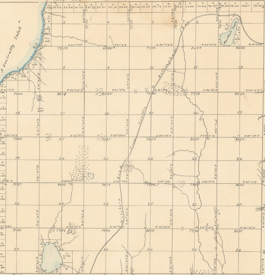
1860 U.S. Bureau of Land Management's Survey Map. Lake Ballinger is at the bottom. 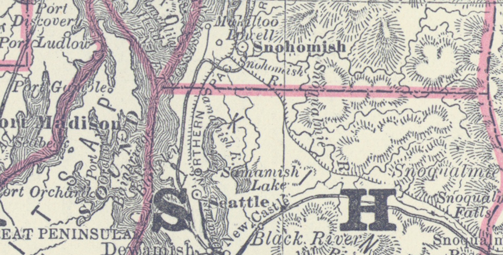
1881 Washington State Map. This map shows the Military Road and the telegraph trail to Mukilteo. 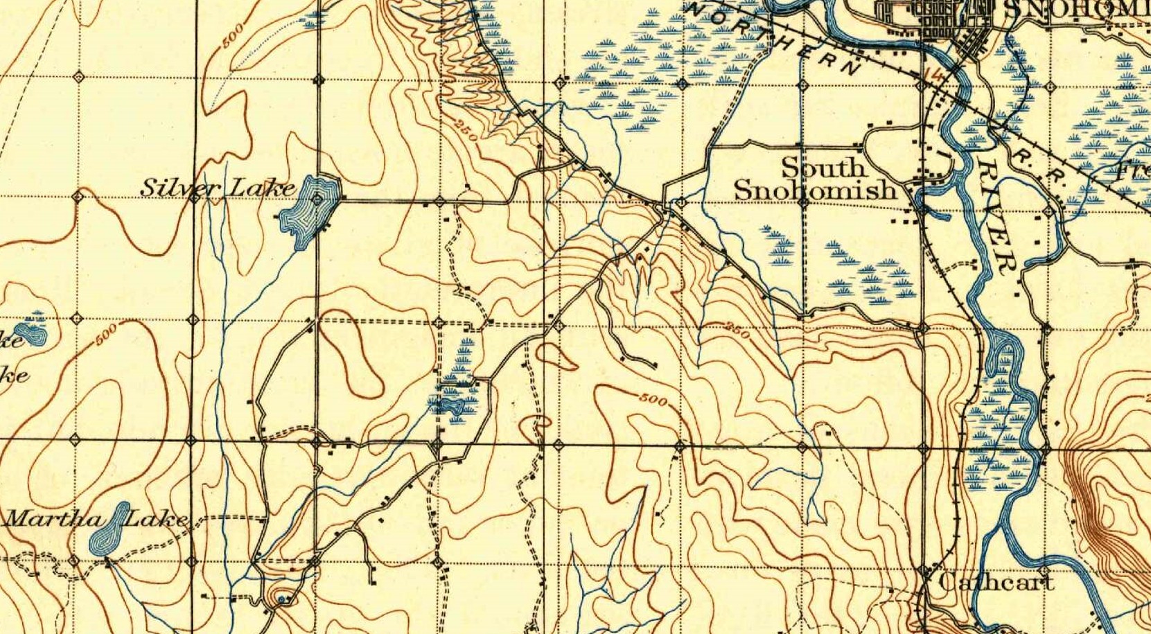
1894 map showing Seattle Hill Road and the Pacific Highway running along Silver lake into Everett. 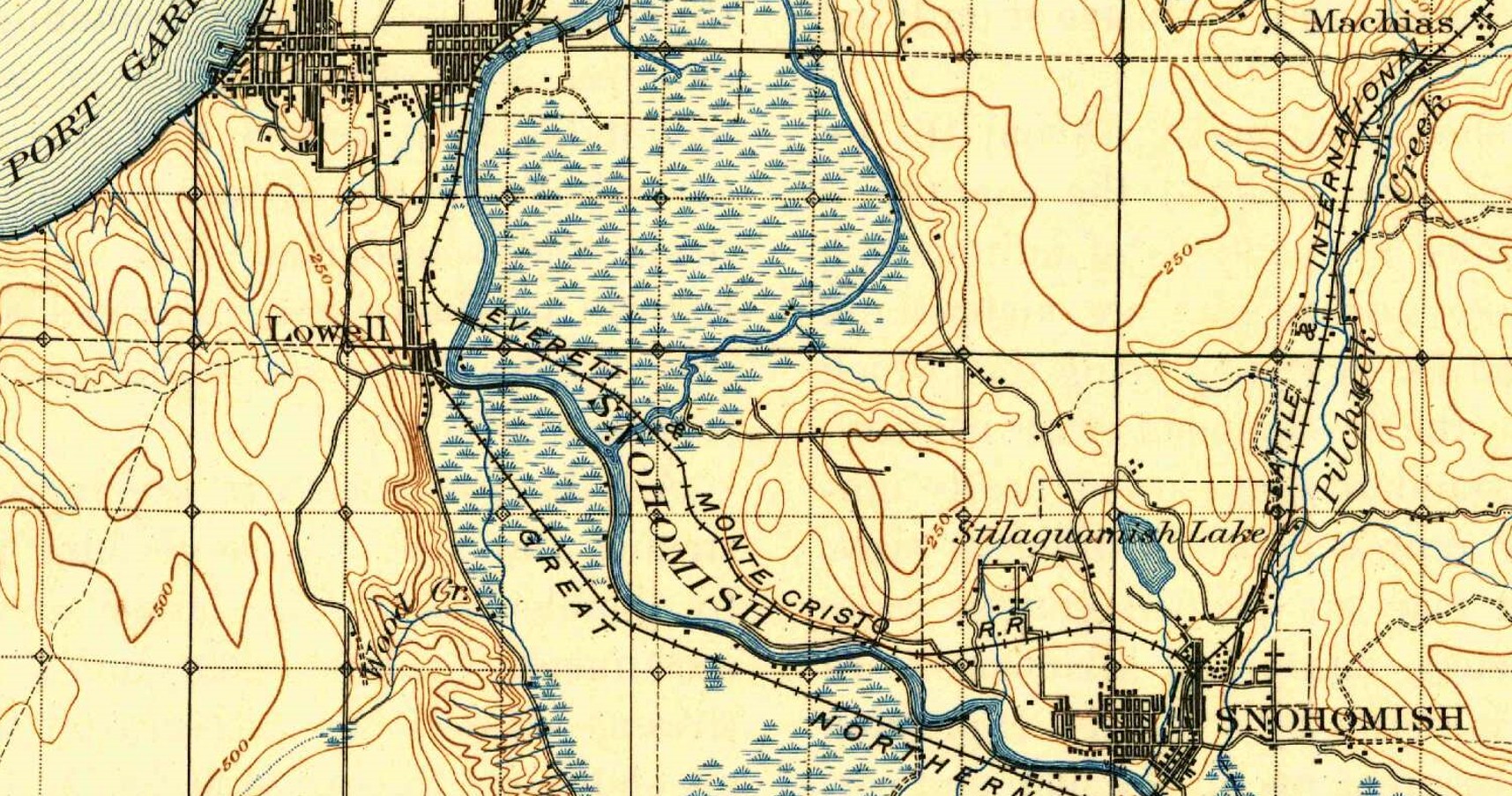
1894 map showing the the roads to Lowell and Everett. |
©2011-2022 pacific-hwy.net
All Rights Reserved