![]()
The Historic Pacific Highway
in Washington
Whipple Creek Crossing
![]()
The Historic Pacific Highway
in Washington
Whipple Creek Crossing
The Whipple Creek Crossing
By Curt Cunningham
Whipple Creek is located 7.5 miles north of Vancouver. The headwaters of the creek are near the intersection of NE 179th St. and NE 15th Ave., just east of the freeway. The creek drains westerly into Lake River, and is now a part of the 12 square mile Whipple Creek watershed.
The creek is named after Samuel Rodney and Charlotte A. Whipple. The Whipple's were married at Chicago in 1849 and then in 1852, crossed the Oregon Trail. They reached The Dalles on September 19, 1852 and settled on Sauvie's Island. After a short time there, the Whipple's moved near the mouth of Whipple Creek. In 1855, Samuel was elected to the Territorial Legislature, where he served for two terms.
Whipple operated a dairy farm and would make a trip to Portland to sell his milk and butter. The round trip would take him 3 days to complete. They would live a wonderful life throughout the 1860's and 1870's. But death is inevitable and Charlotte, who was born on June 21, 1822, passed away quietly at her home in 1884. Historical Author and Reverend, Harvey Kimball Hines gave the funeral discourse. Several years later, Samuel moved to Los Angeles to live with his daughter Libbie and quietly passed away at her home on February 28, 1907.
The wagon road north from Vancouver to the Salmon Creek mill was built in 1853. In 1865, the U. S. Government wanted another route north to Fort Steilacoom that would avoid the swampy bottom land of the Lake River country, as that road had become impassible. The Military road was moved east at Ridgefield and ran down what is now NW Lancaster Road as it continued down to the Lewis River crossing.
In 1869, the U. S. Government made another improvement to the Military Road between Vancouver and the Lewis River crossing. The old road that followed the Columbia River to Ridgefield was bypassed by an entirely new route. This new road ran in a due north direction from Vancouver on what is now called Hazel Dell Avenue. At NE 117th St. the road turned east to Marble's mill on Salmon Creek. After fording the stream, the military road continued in a northwest direction connecting to NW Hillhurst Road as it drops down the hill into Ridgefield. The locals called this route the "Lewis River Road" or the "Government Road."
Early settler Horace Dewey Tenney, once owned property along the Military Road between NE 134th and Whipple Creek. On February 9, 1877, Tenney was in the process of constructing a bridge across Whipple Creek. The bridge was 120 feet long and would be known as the Tenney bridge.
The area was a dense forest and barely anybody was living there at the time. It was a dark and lonely 8 miles to Ridgefield. Whipple Creek was the 3rd crossing after leaving Vancouver. At first, travelers had to ford the stream until the bridge was built, which was located at the bottom of the gully. The hill on the north side had a 15% grade, which made for a steep climb for those traveling north.
On August 4, 1875, a resident of Vancouver took a trip over to Union Ridge, (now Ridgefield) and this is what he said on the journey back home; "After a pleasant visit, we turned reluctantly away from this rural district and headed for Vancouver. Riding through the somber forests, many were the thoughts of the simple wants, humble ambitions and quiet repose of these happy farmers. Bank futures do not trouble them, Ophir and Central Pacific Stock may be worth one dollar, or one thousand dollars per share, but it is all the same to them, they depend upon the honest hand of toil, have no failures, sleep soundly, and glide peacefully down the river of life without a riffle to disturb its quietude."
In 1877, the bridge over Whipple Creek had been completed and when the spring arrived that year, a Vancouver resident made a trip up to Ridgefield on March 30, 1877. After crossing Salmon Creek, he was now among the firs, and said that; "going on north through the dense forest, we are surprised to find a new bridge, about one mile north of Horace D. Tenney's farm. This is over the gulch on one of the worst hills on the road, and is a fine improvement. Two new settlers have taken lands in this section and are doing good work clearing."
"Their presence is a delightful relief to the solitude of this lonely region. We wish them the success their courage and energy. Refreshment for man and beast is kindly afforded us by Mr. G. L. Lindsley, one of the staunch and industrious young farmers of Pioneer. We were pleased to note the many evidences of industry to be seen on his farm. The road from Mr. L.'s to Union Ridge is muddy, but our horses trotted along briskly for an hour, when, from the summit of a hill, we obtained a fine view of the Lake River Country."
On January 14, 1880, a powerful windstorm blew across Clark County. The damage to the trees was immense. Roughly 40% of the timber was knocked down. There were thousands of trees blocking the road to the Lewis River. Between the North Fork and Vancouver there were about 5,000 tress that had blown over. From Horace Tenney's farm south to Salmon Creek, a distance of about 3/4ths of a mile, 89 trees were across the road. It took two days for a farmer to get through to Vancouver, climbing over logs at times piled nearly 20 feet high.
On July 7, 1910, Clarke County placed ads for the construction of a new bridge over Whipple Creek (at NE 10th Ave.). The county received no bids from contractors due to a labor shortage. The county then placed another ad on July 22, 1910. T. D. Owens of Brush Prairie was awarded the contract and his crew built the bridge for $2,160.
On May 1, 1914, the residents of Sara built a bridge over Whipple Creek about 3 miles downstream from the Pacific Highway bridge (at NE 10th Ave.). The residents had cleared and constructed a road from the Davis place at Sara north 2 miles to connect with the main road. This was known as Adams Road.
In 1915, the state was in the process of improving the Pacific Highway for the influx of tourists that would be flooding the highway when the summer touring season began. The highway was to be graded and all the steep grades were to be eliminated. The Whipple Creek gulley was too steep, and was one of the places where the state realigned the highway. The bridge built in 1910, was probably by now a bit unstable and probably needed to be replaced.
To lessen the grade up the hill, the state rerouted the highway to the east about a half mile. The new alignment runs up NE 20th Avenue to NE Union Road. This was done to make a grade of 5%. At NE 164th you can still see the original 1920 pavement on NE Union Rd., before it becomes blocked by Interstate 5. The old bridge over Whipple Creek was condemned and later removed, which severed the old thoroughfare for the first time since 1870.
The good summer weather of 1915 helped with the road construction between Salmon Creek and Crabb's Corner. Crabb's Corner is located at the intersection of the Pacific Highway and S. 5th Street in the village of Pioneer. S. 5th Street is the road to Ridgefield. Crabb's Corner was named after Stephen and Margaret A. Crabb. The Crabb's were early residents of Pioneer. Stephen Crabb was born in 1832 and passed away in 1918.
The work was progressing rapidly north from Salmon Creek and was now half completed. The contractors had 110 men and 45 teams at work on the road. Their camp was at the Louis Brown farm near the Whipple Creek fill, the hardest place on the road. The new road was built up a gulch (NE Union Rd.) on a 5% grade, whereas the old grade on NE 10th Avenue was 15%.
The General Construction Company of Spokane, did the work with G. D. Lyons as the foreman. The contract included moving 90,000 cubic yards of earth; placing 16,000 cubic yard of crushed gravel; building 175 yards of concrete work and construction of 2,000 lineal feet of concrete culvert. The crushed rock came from a crusher that was located on Whipple Creek about a quarter of a mile from the highway.
On August 28, 1915, macadam paving work began on the highway between Salmon Creek and Crabb's Corner. There were 30 teams engaged in the hauling of the crushed rock from the crusher to the paving site. On September 25, 1915, the clearing and grading work on the 7 miles between Salmon Creek and Pioneer was completed. The macadam paving work was not going fast enough, so the contractor put 2 more crushers in operation to speed up the progress. They wanted to finish the work before the rains came. The horses and mules were then swapped out for a caterpillar tractor that could carry 24 yards of crushed rock. The wagons had a capacity of only 4 yards.
During the summer of 1919, Federal aid funding of $113,016.92 was added to the $50,000 that was already appropriated for the concrete paving of the Salmon Creek north section of the Pacific Highway. Clark County was obligated to pay for the remainder of the balance. After this funding was secured, the Highway Board was then able to initiate the Salmon Creek/Pioneer concrete paving project, which was 6.62 miles in length. The paving was the standard 20 foot width, 6 inches thick on the edges, and 7.5 inches thick at the center. The contract was awarded to the Puget Sound Engineering Company of Seattle for $205,485.31. Work began on August 5, 1919.
On October 30, 1920, a truck driven by George Butts for the Puget Sound Engineering Company, with 20 workmen on board, collided with another truck driven by Fred Barker on the Whipple Creek hill, which did considerable damage. The concrete edge on the fill saved the truck from crashing down the embankment. Fortunately, only one man was slightly injured. The cause of the accident was defective brakes on Butt's truck.
On November 20, 1920, the concrete paving work was completed between the Salmon Creek bridge and Pioneer. The concrete took about 40 days to cure before traffic could drive over it. On January 5, 1920, the Pacific Highway between Salmon Creek and Pioneer was opened to traffic. Now the highway was continuously paved for 14 miles northward out of Vancouver.
On March 7, 1921, work began on new guard rails between Salmon Creek and Pioneer. The work on the concrete posts was completed on April 8, 1921. On December 9, 1921, during a fall wind storm, a tree was blown down over the Pacific Highway at Whipple Creek and struck the top of a concrete post square on the head. The post was driven into the ground flush with the surface and was not broken. The post was made with reinforced concrete, 10 X 10 inches and 7 feet long. The posts were sunk 3 feet into the ground leaving a 4 foot post. Walter A. Schwarz, county engineer, who had a picture taken of the post showing it in the ground, said the blow must have been at least 150 tons.
At the turn of the 21st century, the old farmlands north of Vancouver had been transforming into suburbs as the growth of Vancouver continues its expansion north and Ridgefield expands south. In May of 2017, Clark County began a project to build a new bridge across Whipple Creek at the old Government crossing. County Public Works Director Ahmad Qayoumi said the stretch had been a part of the county’s list of arterial roads. The right-of-way was never vacated by the county so it was no trouble in the building of the new bridge.
There are few north-south roads in the area and by the re-connecting of this old thoroughfare, residents now have an easier access to their homes. The 450 foot long bridge stands well above Whipple Creek at almost 50 feet, which eliminates the old 15% grade. Other improvements made during the construction of the bridge was the installation of shoulders on Northeast 10th Avenue in places where there wasn't any. Plus the addition of bicycle lanes, sidewalks and culverts for storm water runoff. The ribbon cutting ceremony was on December 18, 2018 and the bridge was opened in January of 2019.
It took 104 years for this section of the old Military Road and the original route of the Pacific Highway over Whipple Creek to be reconnected.
I want to thank "Flathead" Fred for alerting me to the new bridge.
Update November 14, 2023
The Mystery Wall
On November 11, 2023 Adam Welch wrote to me about a discovery he had made. At the 1915 Pacific Highway crossing of Whipple creek (Union Ave.) he found an old rock wall. This wall is located along the creek about 200 feet west of the Pacific Highway. The wall is only a few yards long and it is a mystery as to what it could have been. Adam and I could not find anything about what this structure could be. Adam did find pieces of brick on the ground around this wall.
Could this wall possibly be part of an old mill? There were a few mills constructed along Whipple creek over a hundred years ago. I found in an old newspaper from 1909 which spoke of a new shingle mill that was constructed on Whipple creek but it did not say where it was located. This wall is surely a mystery and if anyone reading this knows the answer, please send me an e-mail. Adam had sent in a few photos of this mystery wall along with a photo of the 1915 concrete mini-bridge over the creek.
My thanks to Adam for sharing this discovery with us and we hope to solve this mystery sometime in the future.
Photos of the Whipple Creek Bridge (NE 10th Ave.) under construction in 2018
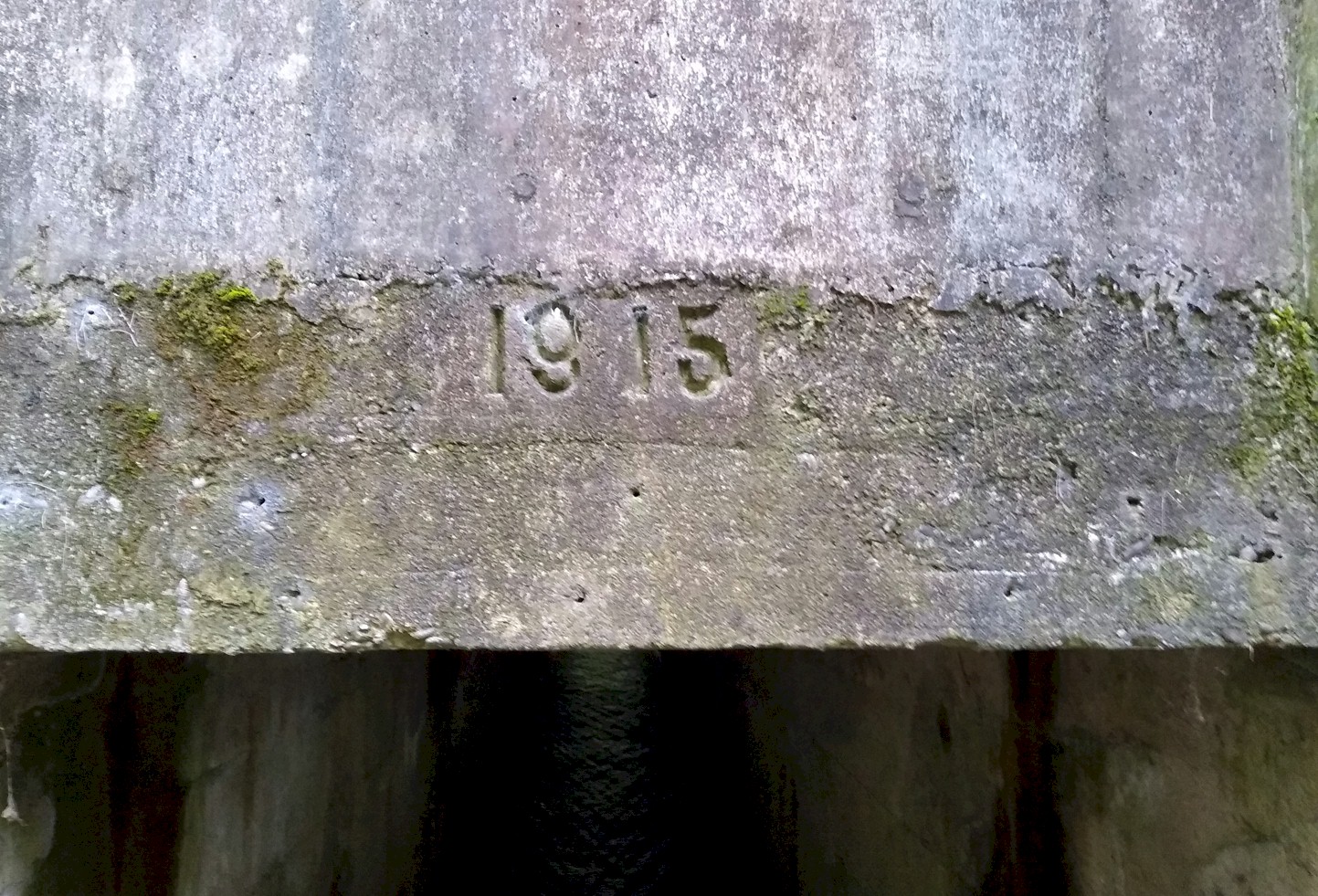
The east side of the Pacific Highway
concrete mini-bridge over Whipple creek.
Photo by Adam Welch.
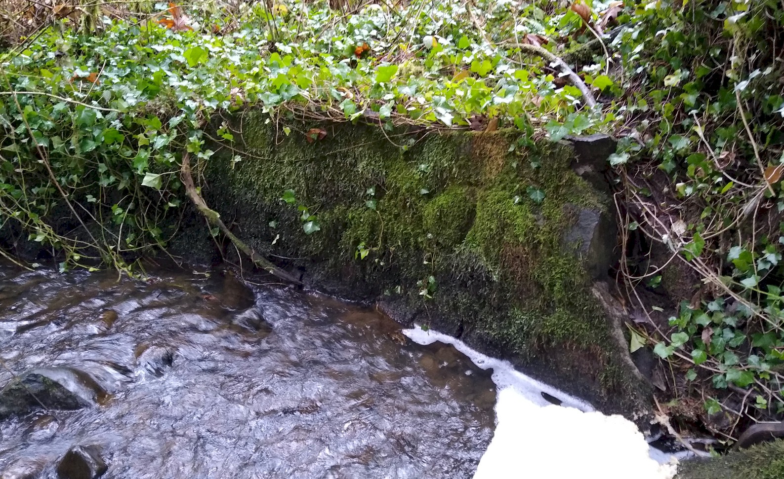
Photo of the mystery wall at Whipple
creek.
Photo by Adam Welch
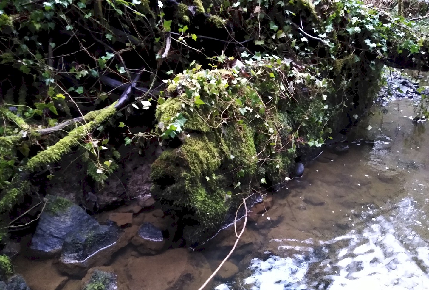
Photo of the mystery wall at Whipple
creek.
Photo by Adam Welch
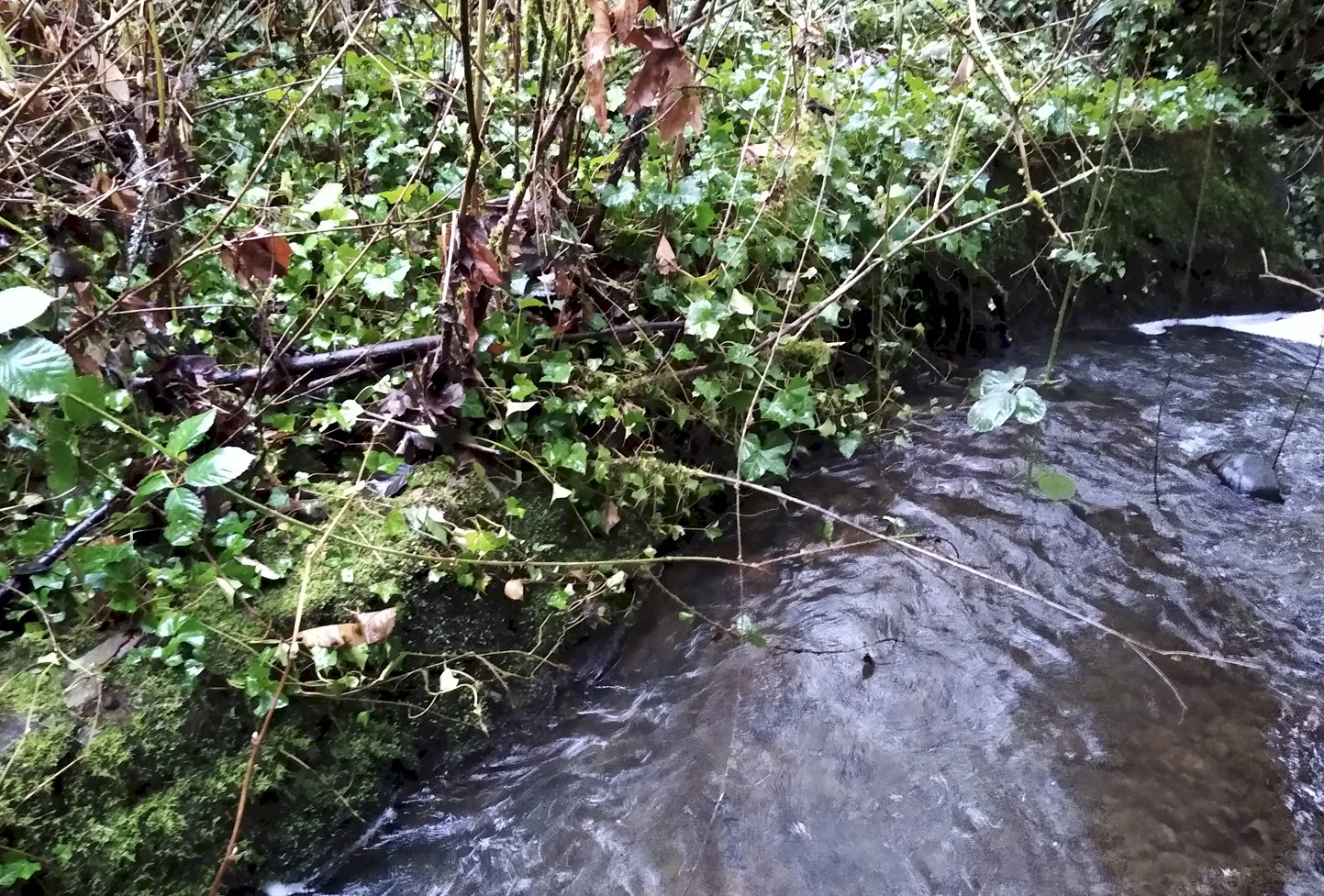
Photo of the mystery wall at Whipple
creek.
Photo by Adam Welch
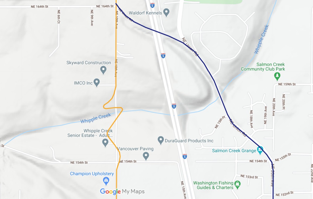
2018 map showing the Military Road and 1913 Pacific Highway in orange and the 1915 Pacific Highway in blue. 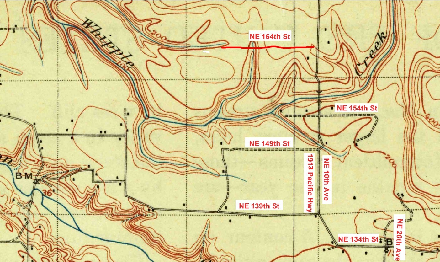
1897 map 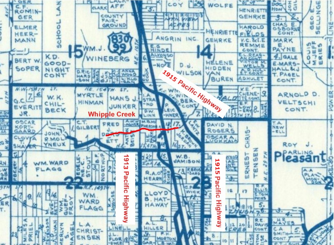
1961 map 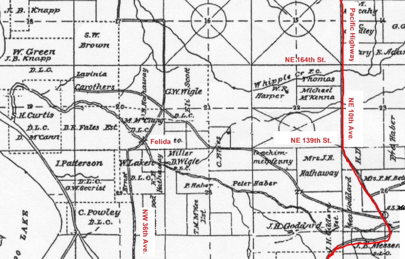
1889 map |