![]()
The Historic Pacific Highway
in Washington
Kalama River Crossing
![]()
The Historic Pacific Highway
in Washington
Kalama River Crossing
Kalama River Crossing
By Curt Cunningham
The first bridge over the Kalama river was a wooden wagon bridge. On the north side of the bridge was an elevated roadway that continued across the bottom land. It is unknown exactly how long the trestle was or when the bridge and elevated roadway was built. It may have been constructed in the late 1880's. The bridge was located about 400 feet east of the freeway. The south approach was built on a steep hillside that required a ledge to be excavated in order to reach the bridge.
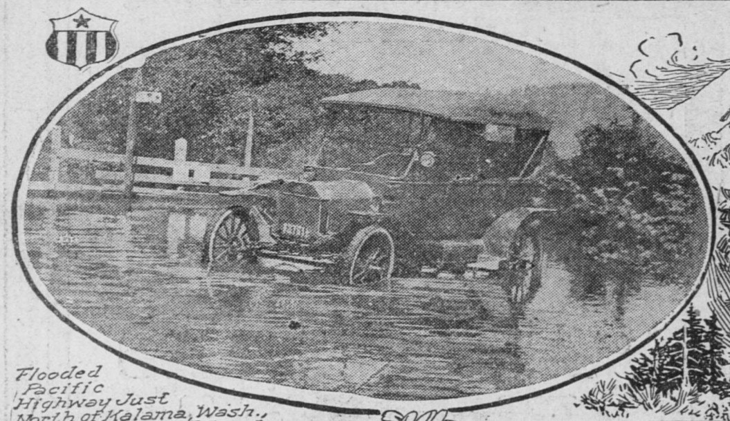
The original highway traveling north from Kalama, rounded the hill before crossing the river. The approach on the north end was across the bottom lands that frequently flooded, which is why the elevated trestle was built. When the river flooded, the road between the bridge and Carrolls Bluff was under about 1 to 2 feet of water. Farmers made $2 a pop, dragging cars through the water with their horses.
Motorists Take a Bath in the Kalama River
On June 21, 1908, Frank Robertson, of Portland, Mr. and Mrs. George B. Waite, of Portland, and Miss Reita Pemberton, of Tacoma were on their way to Tacoma when their car plunged off the 10 foot wooden bridge into 8 feet of water at the Kalama river, where they barely escaped drowning. Their plight was witnessed by several people who rushed to their rescue, and they escaped with only the discomfort of a dunking in the cold water.
Frank Robertson, owner of the car, had just started with the party for a drive to Tacoma. While on the elevated roadway running north, Robertson stepped on the running board to examine a chain. He left the car in charge of Waite. who lost control of the machine, and in a few minutes the big car and all four occupants were struggling with the cold waters of the Kalama river.
Their cries brought a crowd who helped in the rescue. "We expected to take a bath at Tacoma," remarked plucky Miss Pemberton, her teeth chattering with the cold, after she had been helped ashore, "but that won't be necessary now." Mr. and Mrs. Waite and Miss Pemberton took the night train for Tacoma, but Mr. Robertson was determined to proceed with his automobile, which was recovered from the river uninjured.
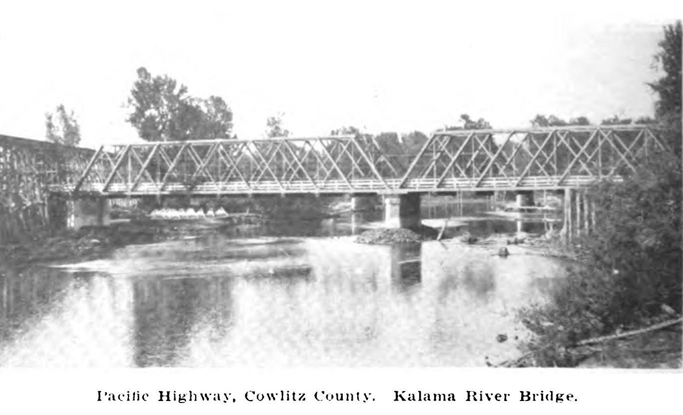
The Steel Bridge Over the Kalama River
In the summer of 1909, construction began on a new steel bridge across the Kalama river replacing the unsafe wooden bridge and elevated trestle. There was no state funding, so the project was paid entirely by Cowlitz county. The structure was built by Kelso contractors Burcham & Byrenes. The new steel bridge was constructed at the same spot as the old one for a cost of $4,000 and was completed in 1910.
The Flood of 1909
On November 8, 1909, from the British Columbia line, south to the Siskiyou Mountains, and from the Cascades west to the ocean, was in the grasp of a torrential rainstorm that lasted for 4 days. The prolonged downpour created flood conditions in many of the rivers, but the damage had been largely confined to the logging industry. The Willamette, Columbia, Lewis, Cowlitz, Chehalis, Washougal, Satsop, Wynooche, Puyallup, White, Stuck and other rivers were all at high water stage and several of them overflowed their banks.
The Cowlitz river reached 12.5 feet above its normal level and flooded many of the towns along the river. The Kalama river also rose and carried away the false work and part of the steel for the new steel bridge. The loss to the contractors was $1,000. They had to pull the steel out of the river and make repairs to it and then rebuild the false work for the bridge. The old wooden bridge was washed away and the highway was cut off until the new bridge could be completed in 1910.
The Kalama Bottom Improvement
The State Highway Commission on March 28, 1917, adopted a budget that would insure completion of the Pacific Highway, particularly with reference to uncompleted sections between Chehalis and Vancouver. Prospects of war had given the highway an increased importance as a road for coast defense maneuvers north and south, especially since completion of the Columbia river bridge. The appropriation included a new bridge across the Kalama and Coweeman rivers.
On June 6, 1917, rumors were flying around that said the Pacific Highway between Kalama and Carrollton was flooded out and impassible. H. S. Rodenbaugh, sales manager of the Mitchell, Lewis & Staver company, who had just driven a new Mitchell from Portland to Castle Rock and then to Mount St. Helens. He said that; "The flooding of the road has been caused by the unusual volume of backwater from the Columbia river and the height of the water on the road will naturally depend upon the stage of the water in the river."
"Last Monday three short strips of road were under water the maximum depth being about one foot, or up to the running boards of the average automobile. All day long a large number of automobiles were making the trip through the water without the aid of horse and team. The only difficulty experienced by any of the motorists was the danger of "shorting" the ignition system by throwing water from the road onto the coll."
"On this account a number were obliged to stop temporarily to mop up the water which chanced to strike the vital parts beneath the engine hood. Even when the water was considerably higher than it is at present, machines were making this trip by the aid of a team, the charge being $2 a car for the lift. In view of the fact that the ferry charge from Goble, on the Oregon shore, to Carroll's Point, above the watered portion of the highway, was $4, most motorists have preferred to take a chance at the water and be pulled out in the event they were stopped."
"The principal danger of plunging into deep water without the guidance of a team is that the car is apt to be steered off to the side of the main road, where the water is deeper than it is on the crown of the road. Despite all reports to the contrary, the regular Pacific Highway route from Portland to Chehalis and on to Seattle is not in bad condition, judging roads from a general standpoint."
Kalama River Bridge and Fill
Bids for the construction of a new steel bridge with concrete piers was opened on May 14, 1917, but all the bids were rejected by the Highway Board on account of them exceeding all the estimates. The state redrew the plans and the bridge design was changed to a timber Howe Truss bridge consisting of two 170-foot spans. It was then re-advertised and the new bidding began on July 9, 1917. The contract was awarded to R. E. Mieth of Portland.
On April 30, 1917, contract No. 287, which called for 1.11 miles of fill across the bottoms, consisting principally of earth embankment, was awarded to Allred & James of Centralia. The roadway, 28 feet in width, was brought to an elevation above the extreme high water level to keep the road from being flooded. The fill was surfaced with gravel 14 feet in width and 9 inches in depth. The work was completed in April, 1918, at a cost of $11,343.89.
On June 6, 1917, The Columbia river rose and the backwater flooded the Kalama river bottom making the road almost impassible between Kalama and Kelso. Motorists taking the ferry from Goble had the option of paying an extra $2 and be taken further downstream to the old Northern Pacific dock that was located just south of Carrolls Bluff, and above the flooded road. H. S. Rodenbaugh, sales manager of the Michell, Lewis & Staver company, said this about the flooded highway;
"Machines were making this trip by the aid of a team, the charge being $2 a car for the lift. In view of the fact that the ferry charge from Goble, on the Oregon shore, to Carroll's Point, above the watered portion of the highway, was $4, most motorists have preferred to take a chance at the water and be pulled out in the event they were stopped."
On April 28, 1918, Joe H. Jordan and some friends took a trip from Portland to American Lake and Seattle. This is what he said about the new road through the Kalama river bottom; "Ferry accommodations for automobiles are fairly good and the skipper is an old timer who can tell of some interesting happenings in that particular locality. About 15 minutes are required to cross to Kalama."
"Out of this little town about two miles to where the road crosses the Kalama river and for a half mile on the other side of the bridge a rough stretch is encountered. Here the motorists gets the first glimpse of the extensive development work being done on the Pacific Highway in Washington. A fill has been made across the lowlands at the mouth of the Kalama river and a new bridge is almost finished."
"This new route will prove shorter than the old one, which during high water always became inundated, making travel impossible from Kalama to Carrolls Point. Between this fill and Carrolls Point construction work of exceptional note has been done around the bluff, which when paved will rival the Columbia Highway for scenery. The road between Kalama and Kelso, with the exception of the places mentioned is good and fair time can be made."
On May 13, 1918, the new Pacific Highway Howe Truss bridge spanning the Kalama river, was completed and opened for traffic. The structure cost $25,667.95 and was built where the northbound lanes of the freeway cross the river. This was to the west of the current bridge on Meeker Drive.
By the mid 1920's, the Kalama river bridge was beginning to fail. On November 4, 1926, emergency bridge repair work was authorized and the repairs were made by state day labor for a cost of about $800. On September 10, 1926, a contract for a new bridge over the Kalama river was awarded to the Gilpin Construction Company of Portland. This new bridge was a concrete "T-beam" with two 177 foot fixed steel spans with 92 feet of concrete "T-beam" approaches that included a 5 foot sidewalk.
In the late 1940's or early 1950's, the construction of the freeway had reached Kalama. To make room for the freeway the old 1926 Kalama river bridge was torn down and replaced by the current Meeker Drive bridge, which was completed in 1952. The old Pacific Highway had to be relocated onto Meeker Drive so the freeway could get through. The north-south portion of Meeker Drive was not a part of the original Pacific Highway.
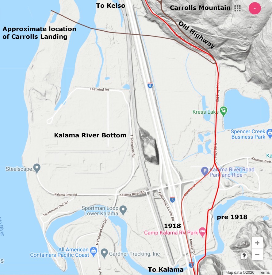
2020 map showing the old and new roads plus the old Northern Pacific dock at Carrolls Point. 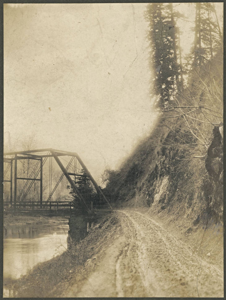 Photo
courtesy Washington Rural Heritage Photo
courtesy Washington Rural Heritage
The 1909 steel bridge 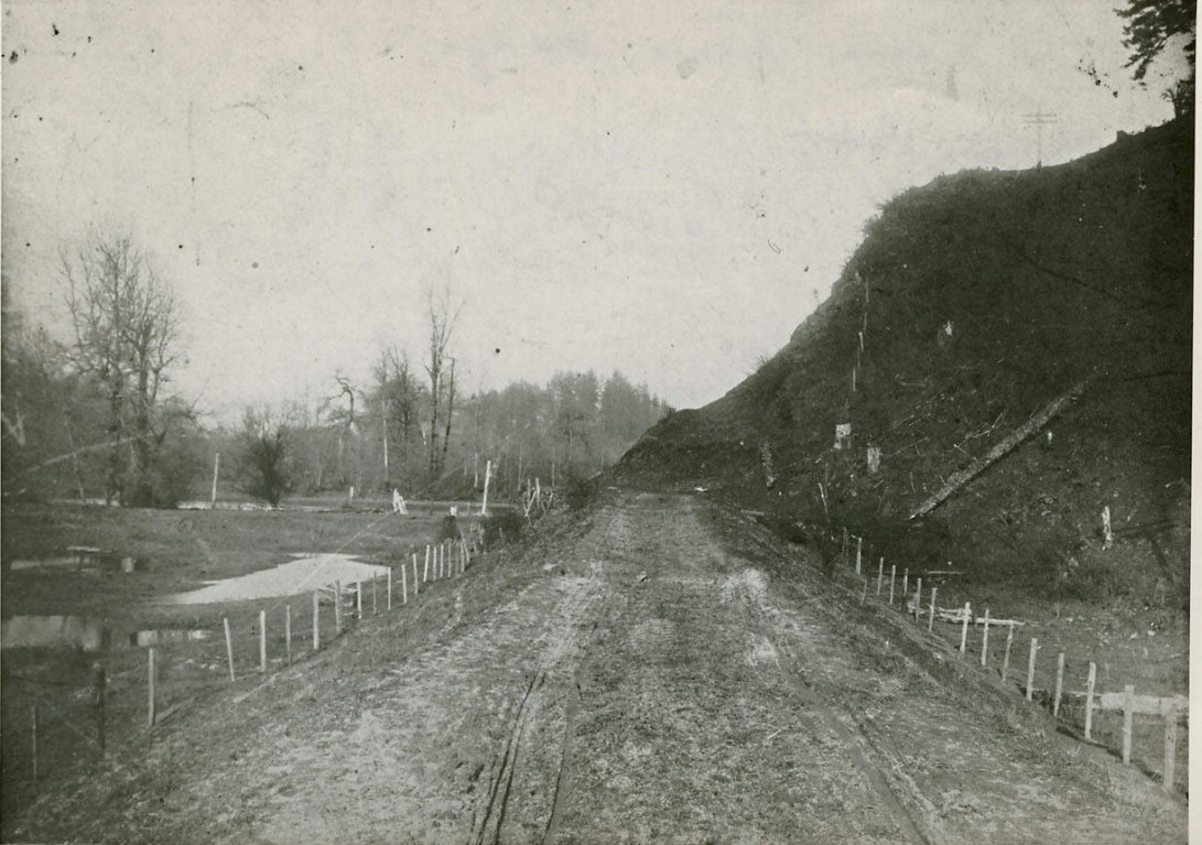 Photo
courtesy Washington Rural Heritage Photo
courtesy Washington Rural Heritage
1909 looking north toward the river. 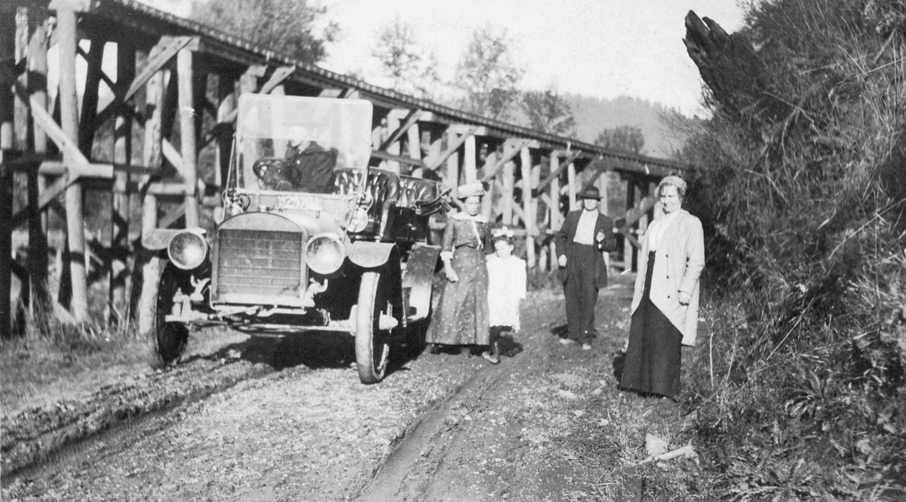 Photo
courtesy Washington Rural Heritage Photo
courtesy Washington Rural Heritage
1915 looking north toward the river. About the same spot as the second photo, just a little further north. The trestle was a railroad logging spur. |
1918 looking west at the new Howe Truss bridge. Photo taken from the old bridge. 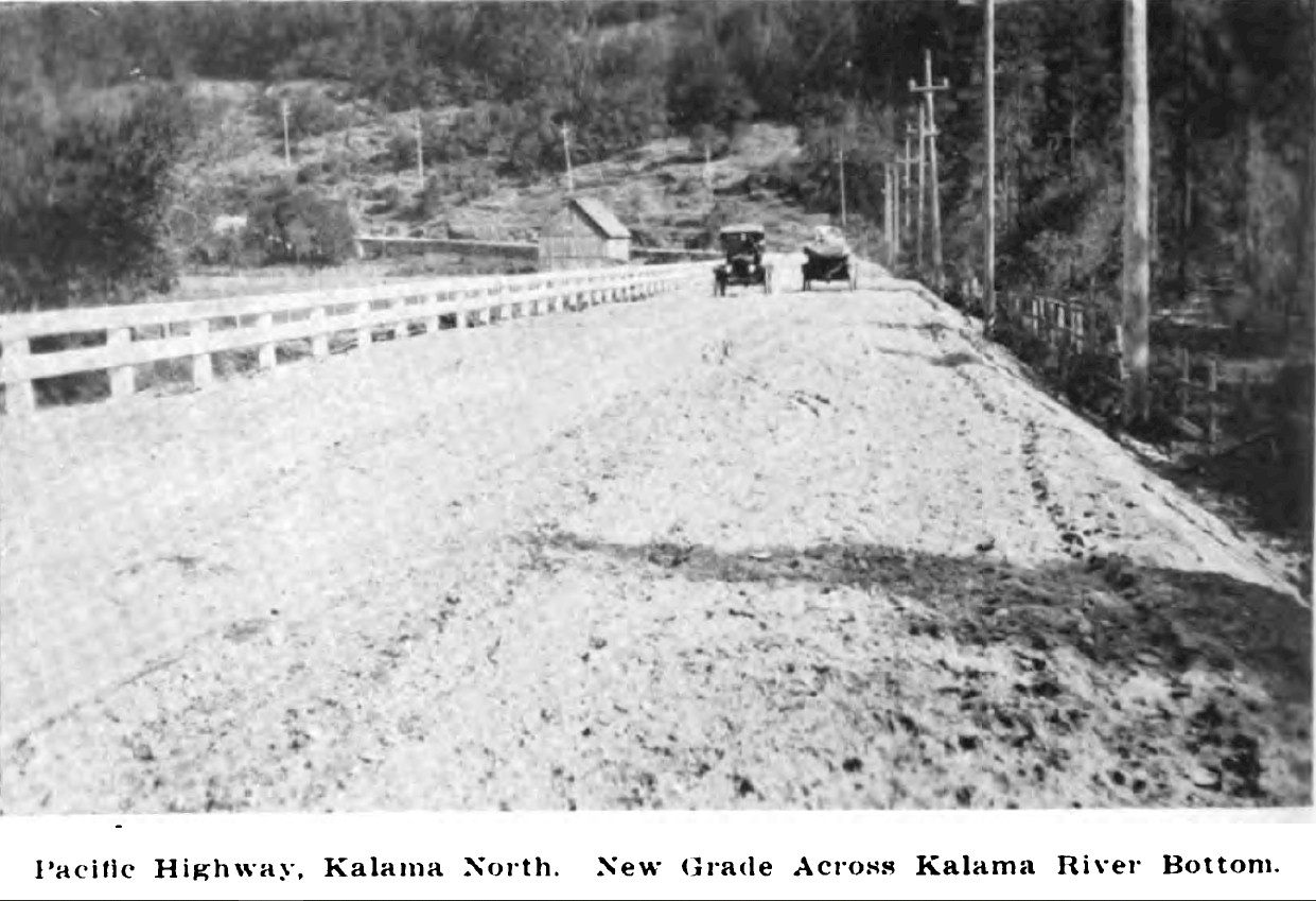
1918 looking north across the newly completed fill. You can see the old highway following the telephone poles up the hill. 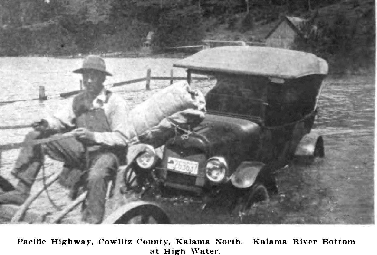
1917 being pulled through the high water. 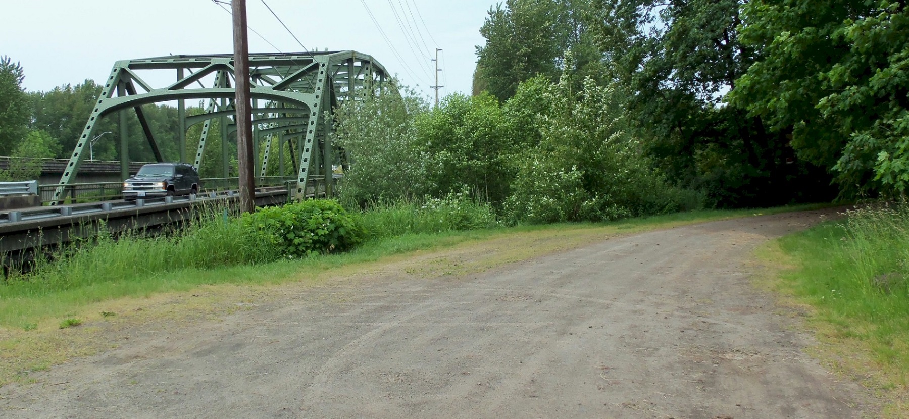
2015 looking north on the old highway at about the same spot as the 1915 photo. |