![]()
The Historic Pacific Highway
in Washington
Crossing the Plains
![]()
The Historic Pacific Highway
in Washington
Crossing the Plains
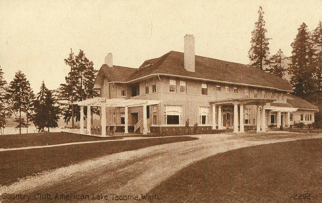
On the back of this undated card it reads; This is a really great place. American lake is lovely and quite large. There are some 50 cottages here and people live here all summer. The golf course is nice and they have some wonderful tournaments. Beginning June 14th some of the biggest players in the U.S. will be there. The Country Club can be reached by train, trolley, or hard surfaced boulevard.
A brief History of the area
between Lacey and South Tacoma
By Curt Cunningham
The Olympia-Steilacoom Road
In the early days of settlement on Puget Sound, Olympia and Steilacoom were the largest population centers. At first the only way to travel between these places was to either rent a canoe or take the trail to the Upper crossing at McKenna and follow the Hudson's Bay road. This long circuitous route was used because the Lower crossing was dangerous and could not be forded. The Nisqually sometimes would camp out at the Lower crossing and ferry travelers across in their canoes for .25 cents a person. Animals would have to swim across but it was very dangerous to do so.
The first wagon road constructed from the Nisqually river up to the plains was in March of 1852 when Dr. William F. Tolmie Chief Factor of Fort Nisqually ordered Chaulifoux, Cowie and several other employees to help in constructing a county road from the fort to the river bottom. They used this road to haul out grass that had been cut which was used as feed for their livestock during the winter months. This road terminated at Steilacoom. That same year a wagon road was constructed between Olympia and Tumwater.
In the summer of 1854 William Packwood established a ferry at the Lower crossing and a wagon road was constructed from Tumwater to the ferry. Wagons from Tumwater and Olympia could now take this new road and cross the river at the Lower crossing. This shortened the route by about 10 miles as wagons no longer had to cross at McKenna. In 1859 the road between Olympia and Lacey was completed shortening the route between Steilacoom and Olympia by another 2.5 miles.
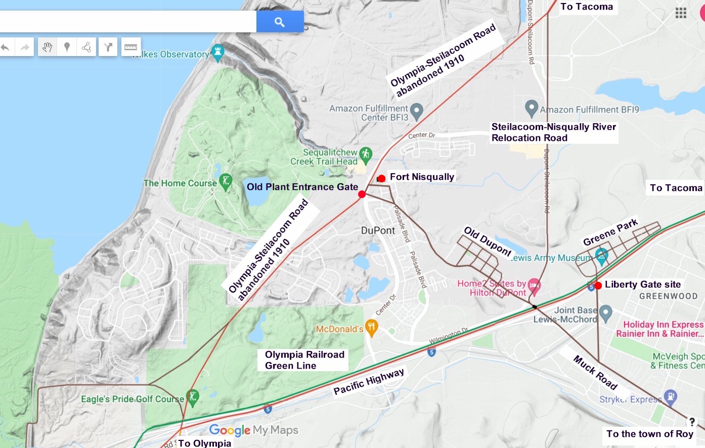
On the east side of the Nisqually bottom, the wagon road climbed out of the valley toward Fort Nisqually and Steilacoom up a steep 15% grade. In 1890 when the Northern Pacific completed it's line from Lakeview to Olympia, they built the tracks across the road at the bottom of this steep hill. Today, this crossing is located just south of the bridge over the tracks, and it is also the site of the Nisqually depot which was built in 1915.
After reaching the top of the hill, the old wagon road continued east for a little over a half mile before it turned to the northwest and crossed the freeway at the Mounts road exit. From the freeway the road continued in a northwest direction through what is now the Eagle's Pride Golf Course, to the site of Fort Nisqually. From the fort the road continued in a northwest direction toward Steilacoom. Today in front of the old fort, a quarter mile section of Center Drive runs directly on this old road. In the 1870's the road would be extended to Tacoma and the old highway would become known as the Olympia-Tacoma road.
The Dupont Powder Works
In 1906 the Dupont Powder Works purchased 2,700 acres of land on the plains northwest of the Nisqually delta. Edward Huggins who had owned the land surrounding Fort Nisqually, sold his property to the company. Huggins had purchased the land at the old fort in the 1870's and was living in the Chief Factors house where he had resided for the last 50 years. The Eagle's Pride Golf Course and the Home Course both occupy most of this area today. The Olympia-Tacoma road between the freeway at Mounts road and the Fort Nisqually site would have to be abandoned.
This is when the Steilacoom-Nisqually River Relocation road was constructed. Today this is a section of the Dupont-Steilacoom road which begins at the freeway and runs north for 1.8 miles where it meets the junction of the old road. At the south end, before crossing the railroad tracks, the relocation road intersects with the old 1838 Muck road. This railroad crossing during the 1910's and 1920's, was known as White's crossing, named for M. B. White who owned the property at the crossing.
The powder plant would become the largest manufacturer of dynamite in the United States, and they needed such a large area of land because they wanted enough empty space around the plant so that in the event of an explosion, no lives would be lost and no damage would occur outside of the company's property. Many accidents unfortunately occurred over its existence resulting in some loss of life.
After the plant was completed in 1909, a company town was built along the old Muck road about a mile southwest of the Fort Nisqually site. Muck road was built to their sheep station on Muck creek in 1838 after the formation of the Puget Sound Agricultural Company, and it runs through the old town of Dupont on what is now known as Barksdale Avenue.
Dupont originally had 60 homes built for a population of 500, but by the end of 1917 there were 100 homes, some of which were inhabited by families of officers who were stationed at Fort Lewis. On March 26, 1912, by a vote of 60 to 2, with one vote scratched, the residents of Dupont voted to incorporate their town, and they elected George Shepard their first mayor. A. Bensch, was elected treasurer. The city council was made up of; Lester Hawley, P. M. Harrington, Howard Cox, E. N. Ladlie, and W. F. Harrington. In 1951 the company would begin to sell the houses to their employees, and in 1974 the company ended operations at the plant.
The Olympia-Tacoma Road
The Olympia-Tacoma road was the first route between Olympia and Tacoma and was completed in the 1870's. The road began at a junction with the old Steilacoom road about a mile west of the American Lake VA Hospital, near where East Dr. meets N. Gate Dr. SW. The original road into Steilacoom was about a half mile east of the current Dupont-Steilacoom road. The Olympia-Tacoma road followed; Gate Dr., Washington Blvd., and Gravelly Lake Dr., as it curves to the northeast and meets Steilacoom Blvd. where the Montamara race track once stood. The road then continued east over the railroad tracks and continued eastward for a quarter of a mile and then curved north toward Tacoma. The popular roadhouse called the "Seven Mile House" was located near this curve.
In the summer of 1907, the State Highway Dept. appropriated funds to Thurston and Pierce counties for construction a new road between Lacey and the east side of Nisqually hill. This road was called State-Aid Road #30. This 7 mile section was completed in 1910, which included a new road down the west hill along with a new steel bridge across the Nisqually river, and a long viaduct over the slough. The road up the west hill was badly constructed and the initial construction was rejected by Thurston county. The road would be improved enough for the contractor to get paid. By 1912 plans were being made to abandon that section of road altogether. In 1915 after 5 short years the steel bridge, wooden viaduct and the poorly constructed road up the west hill would be abandoned for the new Pacific Highway that runs on the old railroad grade.
On April 5, 1909 Pierce county announced plans to improve and shorten the Olympia-Tacoma road between the Nisqually river and Lakeview. The dangerous railroad crossing on the east hill would be eliminated by new wooden bridge constructed over the tracks, and a new 5% grade was built around the hill. This new route bypassed the steep 15% grade on the east hill. This wooden trestle was on the south side of the current overcrossing. In 1917 a concrete bridge replaced the wooden bridge, which itself was replaced in 1928 by a steel and concrete bridge, which was replaced by the current bridge in 2004.
From this overhead crossing, the road only needed to be constructed as far as Dupont. There was an existing road between Dupont and Gravelly Lake Dr. SW. From Ponders a new road was constructed following the tracks of the Olympia line, and it crossed them just north of today's Sounder station. From here the highway continued north on what is now Lakeview Ave. SW. This project was completed in 1910 just as the Pacific Highway was becoming a thing.
The Pacific Highway
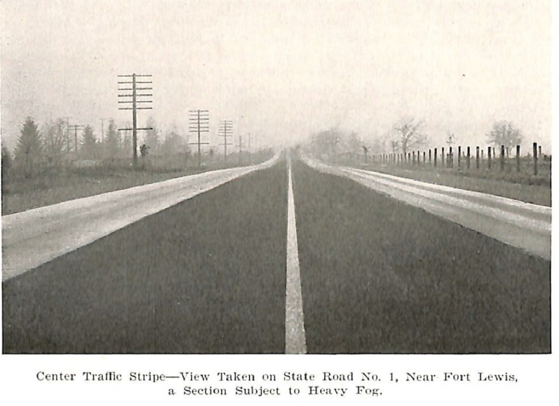
During 1914 the Northern Pacific was busy building the Tenino-Point Defiance cut-off, which enabled the state to use a section of the old Olympia line for the Pacific Highway. All they had to do was connect State-Aid Road #30 to the railroad grade at the top of the west hill, and on the east side, connect it to the highway at the bottom of the overhead crossing. This work was completed in 1915, which finally gave motorists a good graveled road with easy grades between Olympia and Tacoma. During the rainy season it would be a different story as the road across the bottom and on the hills would become a sea of mud making the route almost impassible.
By the summer of 1914 the Pacific Highway had been paved from Tacoma to the Country Club at American lake. Pierce county planned to pave the road the rest of the way to the Thurston county line at the Nisqually river, but on February 2, 1915 they abandoned the idea of obtaining money from the state highway fund and the project was put on hold.
Later that spring on June 18, 1915 Pierce county informed the state highway department, that they were planning to add the 5 miles of paving to the Pacific Highway between the Country Club and Dupont. The county also said they would pave the remaining 5 miles the following year. On July 31, 1915 Pierce county engineer David. H. White placed advertisements for the contract to pave the 5 miles of highway from Country Club to Dupont.
During 1915 the state was in the process of improving the worst sections of the Pacific Highway, and on November 9, 1915 work began on State Highway contract No. 257. This improvement project consisted of grading, draining and graveling about 2.3 miles of the Pacific Highway from the Nisqually depot northerly to the end of the pavement at Dupont. The work was done under the day labor system, and was completed on April 9, 1916. Paving this section of the highway began in the summer of 1916 and was completed by the fall of that year. This section of road was 16 feet wide and was paved with bitulithic on a concrete base for a cost of $34,696.00.
On January 2, 1917, Pierce county engineer David White announced that the Pacific Highway would be closed for paving from the top of the Nisqually hill to a point one mile on the road southwest of the river in Thurston county near Sherlock. Traffic was routed over the Brown bridge and the Old Steilacoom road. By May of 1917 the paving work was completed between South Tacoma and the Nisqually river.
The paving made the road smoother for the motorist, but an unintended consequence was that the speed of the cars increased. This quickly became a problem for the sheriff's office. Buses running between Olympia and Tacoma were in the habit of driving at high rates of speed along the Pacific Highway. Sheriff G. M. Stanley called them "death drives," and said he was going to put a stop to it. On January 22, 1917 several bus drivers were arrested and fined for speeding along the highway at American Lake. Deputy Chilburg caught Drivers Mitchell and Jacobson going 45 and 43 miles per hour, and Stanley arrested drivers Smith and Freeman for speeds of over 40 miles per hour.
In the summer of 1917 the county began to notice the problem with the traffic going between the military camps at American lake and Tacoma. On August 18 ,1917 Pierce county Engineer David H. White said that between 6am and 8pm on Sunday August 12th, 4,490 vehicles passed by Camp Murray and the speedway. The traffic was nearly 10 times as heavy as it was the prior year in July of 1916, when a census showed that only 500 vehicles passed by this section of the highway. In 1914 horse drawn wagons were 5% of the total. In 1917 it was only 1.5% of the total traffic.
On July 2, 1917 Pierce county commissioner Slayden made a suggestion to remedy the traffic problem by using the old Union Pacific right-of-way which ran on the west side of American lake and northwest through Lakewood toward Tacoma. This road would run from the west end of Center St. west of the South Tacoma car shops, across the prairie to the west end of the Montamara Speedway, then to the north side of Gravelly lake to American lake and Dupont, where it would meet the Pacific Highway. Slayden said; "The present road cannot carry the traffic to the army post. It is only 20 feet wide to the race track, and from there only 16 and 17 feet wide. A road would have to be 100 feet wide all the way to handle the traffic which will soon be on the highway between Tacoma and the Army post. To widen the present road would be more expensive than to build a new one."
Then 4 days later on July 6, 1917 the Tacoma Times said the City of Tacoma would improve the road to the post, if; "the Tacoma bankers would purchase bonds for the new tide-flats trolley line, thus releasing $160,000 of city money that would have been used for the construction cost, Tacoma would then be able to improve the roadway conditions to the army post."
The necessity of either building a second roadway to the army post, or widening the present paved road, to accommodate the growing vehicle traffic, as proposed by The Tacoma Times, was acknowledged by all the officials. The city had no available funds for widening pavement or building new roads, inside the city limits. The strip of pavement known as "Edison boulevard," from Center street to South Tacoma, and that portion of Union avenue from 58th street to the city limits, was only 20 feet wide and had already proved inadequate to accommodate the rush of traffic.
The Tacoma bankers refused to take on the street-car bonds. A. B. Howe, president of the Tacoma Commercial club, told the commissioners that he would interview all bankers within 24 hours and attempt to induce them to take up the tide-flats carline bond issue. As a temporary means of relieving congestion, the police ordered traffic diverted so that only half of it went south via Edison boulevard, and the other half followed the South Tacoma carline to South Tacoma. Sometime years later Tacoma built this road and today it is called S. Orchard St. and Lakewood Dr. W.
The county commissioners were also ready to widen the pavement between Tacoma's city limits and Dupont once they secured funding, and a roadway at least 35 or 40 feet wide would be necessary. Fred Kenworth, of South Tacoma had told the commissioners that Maj. Liggett, who was in command of the western forces, had advised him that the only reason state troops were not ordered to mobilize at American lake that summer was because of Tacoma's lack of facilities.
On July 13, 1917 the U.S. Army made a warning to motorists that if the speeding on the Pacific Highway through the American lake post continued they would commandeer and close the 9 mile stretch of road through the fort forcing drivers traveling between Tacoma and Olympia to go via Yelm and the Upper crossing. Captain Harry K. MacKay made a formal complaint with the Secretary of State and after talking the situation over, Secretary Howell deputized him will full authority to arrest traffic violators and he also told him he could have as many deputies as he required.
On August 2, 1917, J. T. S. Lyle, chairman of the "road to post" committee reported to the members council that he believed that a new road could be built, running parallel to the Pacific Highway, each to be a one-way road. Officers at the post favored this plan. They were taking about a "4-lane highway," which would be constructed in 1921 between Lakeview and Camp Murray. Through Tacoma the Pacific Highway remained a 2-lane 20 foot wide road.
Camp Lewis
On September 8, 1917 printed in the Seattle Star is an article announcing the opening day of Camp Lewis, which is known today as Joint Base Lewis-McChord. They said; "Uncle Sam's $7,000,000 training camp for the select service heroes of Western states is open for business here. If you are one who cannot realize that democracy is at war. Camp Lewis, or any one of the 15 similar cantonments scattered over the nation, will offer convincing proof. No more beautiful spot on the West coast could have been chosen for such a camp. A tangled forest of Christmas trees, a slightly, refreshing lake and 76,000 acres of land as level as a kitchen floor. And by the elbow power of thousands of workers, a pioneer city of bright, new, unpainted wooden buildings, disappearing in the distance in a seemingly endless line. That's the sort of a home the government has prepared for the 46,000 boys from Alaska, Washington, Oregon, Idaho, Montana, Wyoming, Utah, Nevada, and California."
On October 2, 1917 the Tacoma Times said that; "Capt. Welty, adjutant to Gen. Greene, laid his finger on a question that was of supreme importance to every Tacoma businessman when he calls attention to the urgent and immediate need for better transportation facilities between Tacoma and Camp Lewis. We simply have to have them. It is imperative for Tacoma that we do what is desirable for the army. The cantonment is going to be served; if not from here, from elsewhere. We must improve the automobile highways. Every device must be utilized to make the present pavement carry all the traffic it possibly can with safety. And the proposed million-dollar trunk road must be rushed with all possible speed."
On October 10, 1917 After failing to get help from the war department in building a suitable army post road, Hugh Wallace of Tacoma along with W. R. Rust and Congressman Albert Johnson called on the Secretary of Agriculture to ask for a federal allotment from them. They wanted $850,000 for a road beginning at Wilkeson and Center streets, cross the Northern Pacific tracks at Trafton street and run south to South Tacoma, turn at 66th and Union and cross Clover park and the west end of Sequalitchew lake to Dupont. I do not believe the funding was granted from what I could tell.
On October 22, 1917 the Tacoma Times said that; "Except for holidays or other special occasions, Western Washington probably never has seen a concentrated mass of auto traffic as gathered Sunday afternoon and evening between Tacoma and Camp Lewis. For hours the Pacific Highway was lined with 2 streams of cars one going and the other coming, as close together as they could operate with safety and for much of the distance only able to make not more than 12 miles per hour. After dark the spectacle on the prairie, where one could see a line of blazing headlights for miles back, was unusual and beautiful in the extreme."
On November 17, 1917 security was tightened at Camp Lewis because of the events taking place at the southern border with Mexico. The Tacoma Times said that; "getting in and out of Camp Lewis isn't as easy now as it was a few weeks ago." Every night a cordon of guards surrounded the camp from retreat at night until reveille in the morning and every passerby between those hours was forced to wait while the sentries unwound the red tape prescribed by the rules and regulations. This is the way it worked; A bus with one lone civilian for a passenger leaves the camp at 2am.
On its way to the Pacific Highway it is halted. A guard, with his rifle slung like a bar in front of him, steps into the glare of the headlight. "Who's there?" "bus driver," is the reply. "Advance, bus driver, and be recognized." Growling at the inconvenience, the driver descends into the mud and walks toward the guard in the rain, It is pitch dark, neither can see the other. "Pass bus driver," says the guard, and the bus takes up its journey. A few feet further another guard and the same ordeal begins again.
Perhaps 3 would be passed within 1,000 feet. The passenger then leaves the bus and starts across the railway tracks to his home in Dupont. A sentry cries halt! "Who's there!?" "Friend of the camp," says the civilian. "Advance friend and be recognized." Friend advances and stands in a puddle. "Are you a resident of Dupont?" he is asked. "He is," says the civilian. "Pass Resident of Dupont," and both go paddling through the rain.
On December 6, 1917 Maj. M. Y. Croxall of the Camp Lewis military police gave warning to the army post bus drivers that if they failed to observe regulations, and if they attempt to charge exorbitant rates to soldiers, the government would commandeer the Pacific Highway through the military reservation to a point beyond Camp Murray. He then said the military police would not consider an increase in rates for soldiers. Certain bus drivers had attempted to raise the rates from 35 to 50 cents. Maj. Croxall said it had been reported to him that certain drivers had charged as high as $1.50 for a return trip to Camp Lewis from Tacoma late at night.
On June 27, 1918 soldier Mirum F. Stout wrote to the editor of the Tacoma Times about drivers who would not pick up soldiers who were walking along the Pacific Highway between Tacoma and the camp. He said that; "Not many months ago articles and editorials appeared in numerous papers all over the land on "Giving the Soldier a Ride." From my observations, however, while making trips between the camp and Tacoma I am led to believe that a number of people did not read said articles."
"Any soldier or sailor in this country wearing the uniform of the U. S. army or navy, or a soldier of any of our allies is entitled to a ride, and any citizen of the United Stales or a citizen of any of the countries with which we are today co-operating in order to put down the Hun, destroy militarism and preserve democracy is under obligation to give him a ride. On Saturdays, in particular, the traffic is congested to such a degree that soldiers desiring to go in to Tacoma are obliged to stand in line for a long time. Many of the boys become tired of waiting and take their places at various points near the cantonment along the Pacific Highway, where they hope to catch a ride in the machines of kindhearted individuals. Some of them even walk to the car line at Murray, four miles away."
"Don't think that these men are soliciting free rides. They want to get to Tacoma as quickly as possible. Some of their passes are good only for 12 hours. Most of them have the means to pay their fares and would be only too glad to do so if the transportation facilities were adequate. But do not let this be your excuse. Simply bear in mind that the soldier's entitled to a ride. It is true, tho, that quite a number of the boys need every cent they receive. Some of them have dependents, and after their allotment and insurance premium are deducted, they have very little money left."
"The latter you will find not only on Saturdays, but on every evening of the week waiting to catch a ride in order that they may visit dear ones at home. Don't disappoint them. Last Saturday in going from Camp Lewis to Murray several automobiles passed me having room for from one to four persons more than they were carrying. At the entrance to the camp, in front of the depot and at the Greene Park bus station scores of soldiers were waiting for a ride. A few were walking along the highway to Murray. Three machines passed right by them. Some of these autos were driven by officers."
"Will it impair an officer's efficiency if he allows a soldier to ride with him? Will it undermine the discipline in the army? Will it hurt his standing? It won't with me. How about you, Mr. Liberty Bond Purchaser?"
Well the Army didn't see it that way and on September 9, 1919 a Fort Lewis soldier wrote to the editor of the Tacoma Times about the conditions at the base. One of the things he said was; "An order came out last night that hereafter all soldiers will be prohibited from soliciting rides from persons in automobiles on the Pacific Highway or other roads, as it is a form of begging, and a disgrace to the uniform, and that the military police will place under arrest any soldier caught asking for a ride. I am of the opinion that it's more of a disgrace to the country that the soldiers are not either paid more, or else allowed to ride for a cent a mile."
"I suppose some patriotic profiteer made a howl because some soldier had the audacity to stop him in the road when he was trying to break the speed limit, or else the bus company put in a complaint that good money is being saved by the soldiers which they feel they should get. It is a shame that a soldier should disgrace the uniform by asking for a ride when he gets the large and juicy sum of $24 from his country."
The New Danger Signal
On January 8, 1918 the Tacoma Times said that a new danger signal had been placed on the Pacific Highway. They said that; "the next time you drive south from Tacoma out by the Seven Mile House late at night, don't be unduly alarmed when a large red light looms up ahead and a little to the port. Just slow down and take the curve thus indicated at a reasonable speed." This was the first use of safety reflectors, which we see today on most highway curves, though today they are mostly yellow. These reflectors were placed at the curve in the highway which is now the intersection of South Tacoma Way and Steilacoom Blvd.
They also placed these reflectors at a curve on the Pacific Highway near Fife. "This danger signal is something entirely new and is going to prove a boon to the motorist," said Assistant Manager Brokaw of the Automobile Club of Western Washington. "We urgently request the automobile owners of Tacoma to drive to one of these corners some night soon and then write us their opinion of the signal. This danger signal contains no light but is so constructed that it picks up the white headlights of an approaching car and reflects them red."
The 4-Lane Pacific Highway
On February 20, 1918 the Pierce county commissioners decided to spend approximately $100,000 to widen 4 miles of the Pacific Highway between Camp Murray and Steilacoom Blvd. at Lakeview. They also made plans to build a new road to Fort Lewis beginning at the northwest corner of the Speedway on Steilacoom Blvd. to a connection of the highway southeast of Gravelly lake and an extension from Gravelly lake to the end of the Pacific Traction line at Lake City, then along the west side of American lake to Dupont.
Pierce county had also condemned, paid for, and deeded to the government all the land from Fort Lewis north, and on the west side of American lake to the end of this proposed highway, which was to be used for military purposes. On a 1928 county map it shows American lake county road, running on the west side of American lake between the end of the trolley line at Lake City and terminating at the main gate of Fort Lewis. Today, N. Lake Dr. SW and Veteran's Dr. SW are remnants of this old road.
In the summer of 1918, crews were busy paving the 4 miles of the Pacific Highway from the Tacoma city limits to the north boundary line of Fort Lewis, for a cost of $96,385.30. This improvement, widened the existing paved road from 16 feet to 32 feet wide between Steilacoom Blvd. and the Country Club at American lake.
Then 3 years later the state widened 4 miles of the highway between the Country Club and Fort Lewis. On September 7, 1921 state contract No. 555—Country Club-Camp Lewis Section, of the Pacific Highway was awarded to the Harrison & Johnson co. of Tacoma. The road to be improved was 4.14 miles in length beginning at Ponders corner and ending at Fort Lewis. On September 21, 1921 construction began and the road was graded, and widened with an additional 9 feet of concrete paving on each side of present paved road. This would make the roadway 34 feet wide with 4 lanes between South Tacoma and Fort Lewis. The project was completed on November 14, 1921. The contract price was initially $10,660.90; with the final estimate being $9,096.18, making the average cost per mile $2,197.14.
On April 16, 1925 state highway contract #934 was awarded to F. McClellan. They had the lowest bid at $76,077.51; with the final estimate being, $77,820.44. This was for the widening of 5.89 miles of the Pacific Highway between Dupont and Ponders. Work began on April 22, 1925 and crews were busy all summer adding 9 more feet to both sides of the existing highway. This project was completed on August 20, 1925. Each lane on the 5.89 mile stretch was now 12 feet wide, which is today's standard width.
In 1935 the Pacific Highway began it's final major transformation into a modern highway. That year the state was in the process of constructing the Nisqually cut-off across the Nisqually river bottom. This new 4-lane road was connected to the end of the existing 4 lane pavement at Fort Lewis. In Lakeview the railroad crossing of the Olympia line was to be eliminated with a new under crossing of the mainline. Construction of this 1.63 mile stretch of road began in the spring of 1935. On May 7, 1935 the contract for the new "Lakeview Undercrossing" was let, and construction began soon after on the 183 foot steel structure over the highway, which was completed on November 12, 1935.
During the mid 1930's, the state highway department was putting a considerable effort toward obtaining structures which would be pleasing to the eye as well as being structurally adequate. They recognized that it was nearly always possible to combine strength with beauty by taking proper attention to the design. One example of this effort was the "Lakeview Undercrossing" on State Road No. 1 between Fort Lewis and Tacoma where the approaches to the railroad bridge were landscaped by road crews.
On May 27, 1935 state contract #1973 was awarded to Joseph Warter Sr. for the paving of 1.63 miles at Lakeview. When this project and the Nisqually cut-off was completed in 1937, the Pacific Highway became a 4-lane road between Tacoma and Olympia.
Sodium Vapor Fog Lights
After the completion of the new highway in 1937, the state installed on 2.9 miles of the Pacific Highway between South Tacoma and Lakeview a system of sodium vapor fog lights. The sodium vapor lights were the latest development for use in connection with highway lighting, and at the time of the installation, was the longest of its kind in the United States. This installation was made as an experiment and had proven to be quite effective in making driving safe in heavy fog infested areas.
The Traffic Light
In 1939 a Tacoma resident wrote in to the Tacoma Times and said; "For months there has been talk of installing a traffic light at the intersection of the Steilacoom and Pacific highways, a point known as the “Seven Mile House.” It is at this point that the ever increasing traffic from the Lakes district must break into the heavy flow of North and Southbound vehicles on the main line. Even when visibility is good and at hours when the traffic is light, the intersection presents unusual hazards, but when the district is enveloped in fog, when it is raining, or when the heavy week-end “load” is racing North and South on the Pacific Highway, the intersection is without question the most dangerous in Pierce county."
"Residents of the Lakes district and the city of Steilacoom are entitled to the protection of a full-functioning traffic light . . . a caution light will not answer the purpose! In addition to assuring the safety of those who must enter the Pacific Highway at this point, the installation of a traffic light . . . red and green . . . will serve another useful purpose. It will tend to slow down the fast moving traffic on the Pacific Highway as it enters the busy 35-mile zone which lies just outside the south city limits."
"Tacoma is growing up and the number of people living outside its boundaries is ever increasing. The competition of McChord Field will intensify the congestion at all points south of town, The very fact that the intersection is so dangerous is the only reason that accidents have been so few. . . motorists realize it is a “hot stove” and are reluctant to “touch,” lest they burn their fingers."
"Our county commissioners should insist on the State Highway department installing a full-functioning traffic light at the Steilacoom-Pacific Highway intersection at once! It is during the next five or six months the protection is most needed, when highways are wet and slippery, when visibility is poor. Motorists who find it necessary to negotiate this hazardous intersection are daily gambling with death and it just doesn’t make sense, Let’s have a traffic light, commissioners.....and let's have it right now."
History of the Steilacoom Plains
Photos of the Pacific Highway near Lakeview
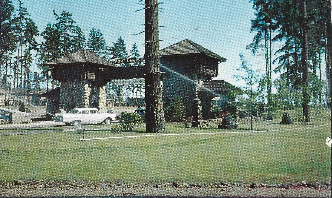
Liberty Gate in 1950 (original location)
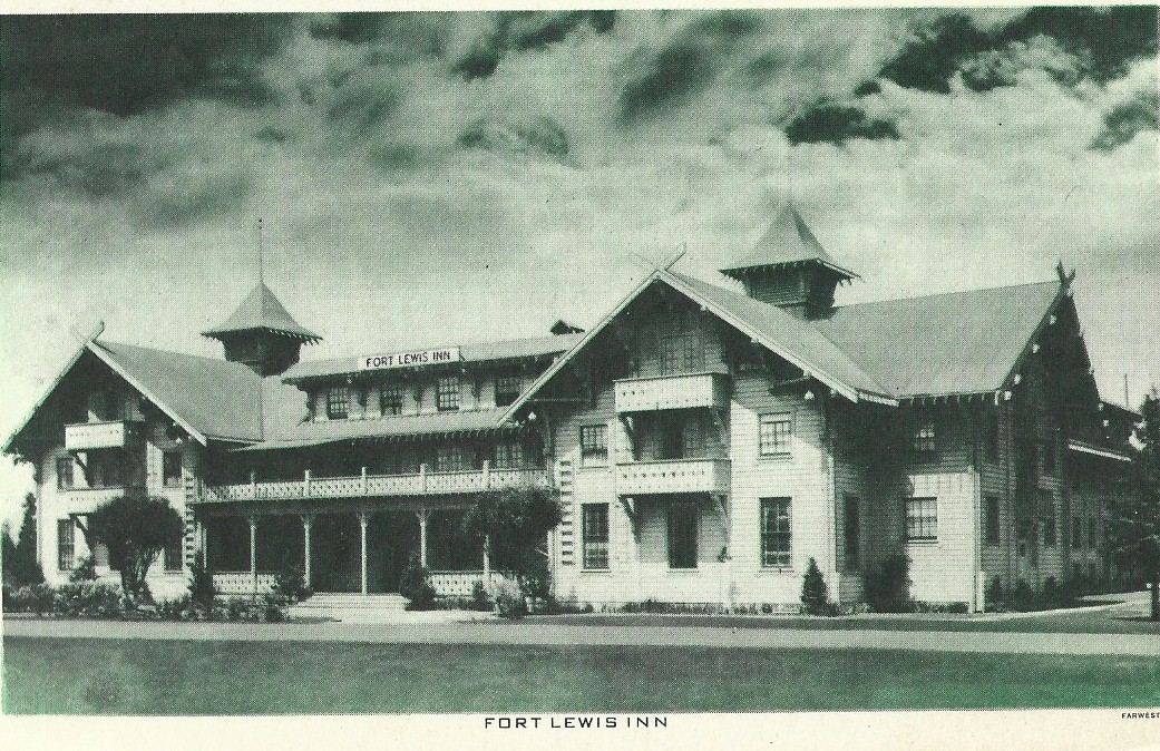
Fort Lewis Inn
2022 map 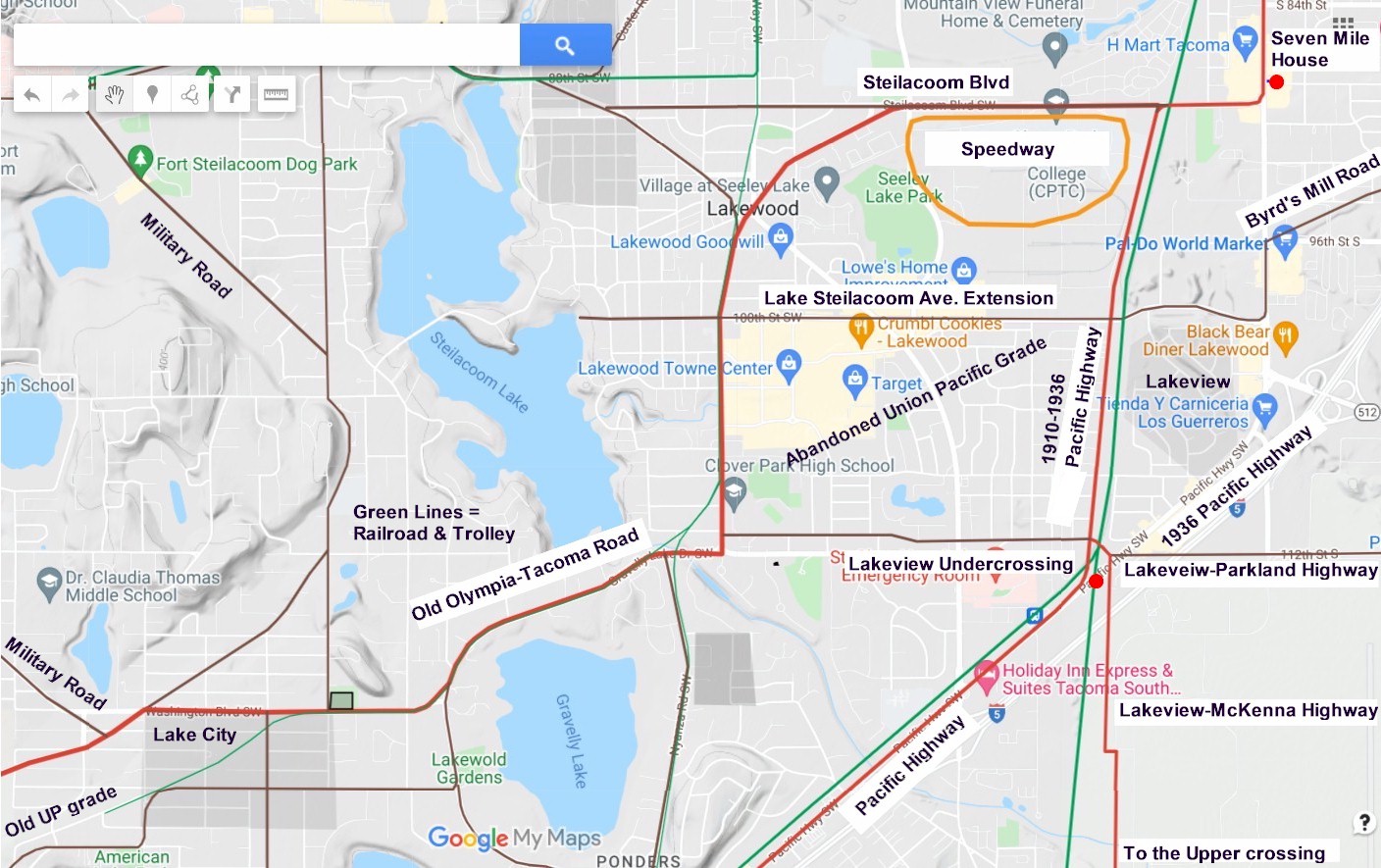
2022 map 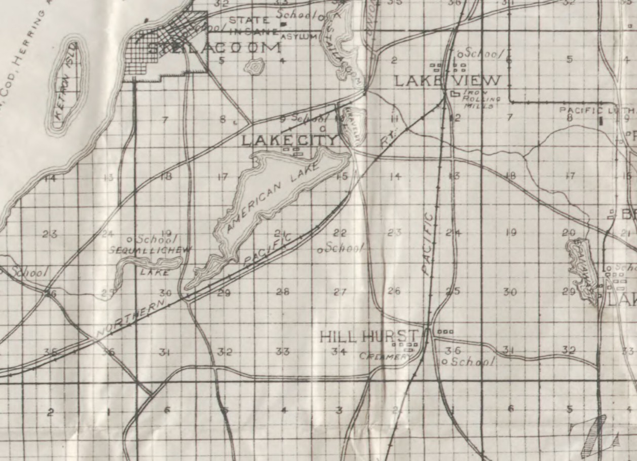
1897 map 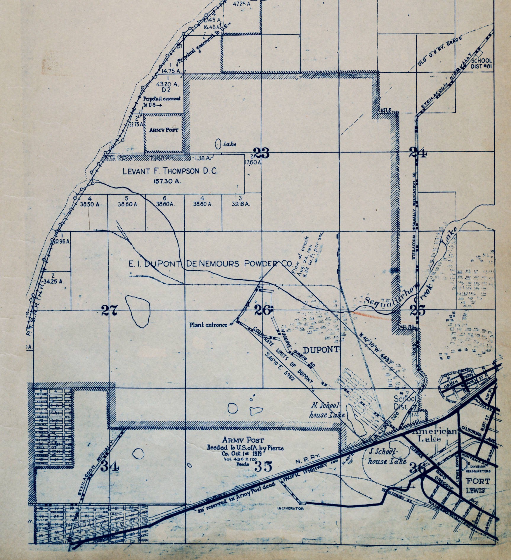
1928 map showing the Steilacoom-Nisqually River Relocation Road. |
1934 Pacific Highway at Fort Lewis. You can see the 9 foot pavement extension on both sides of the highway. 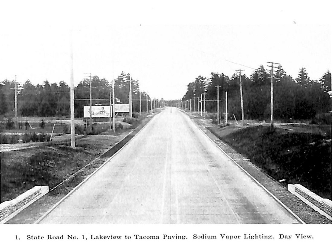
1937 Pacific Highway north of Lakeview. 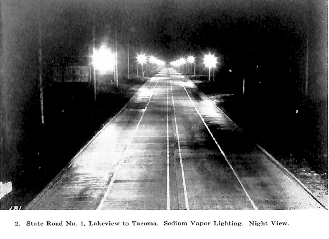
1937 Pacific Highway north of Lakeview at night with the sodium vapor lights. 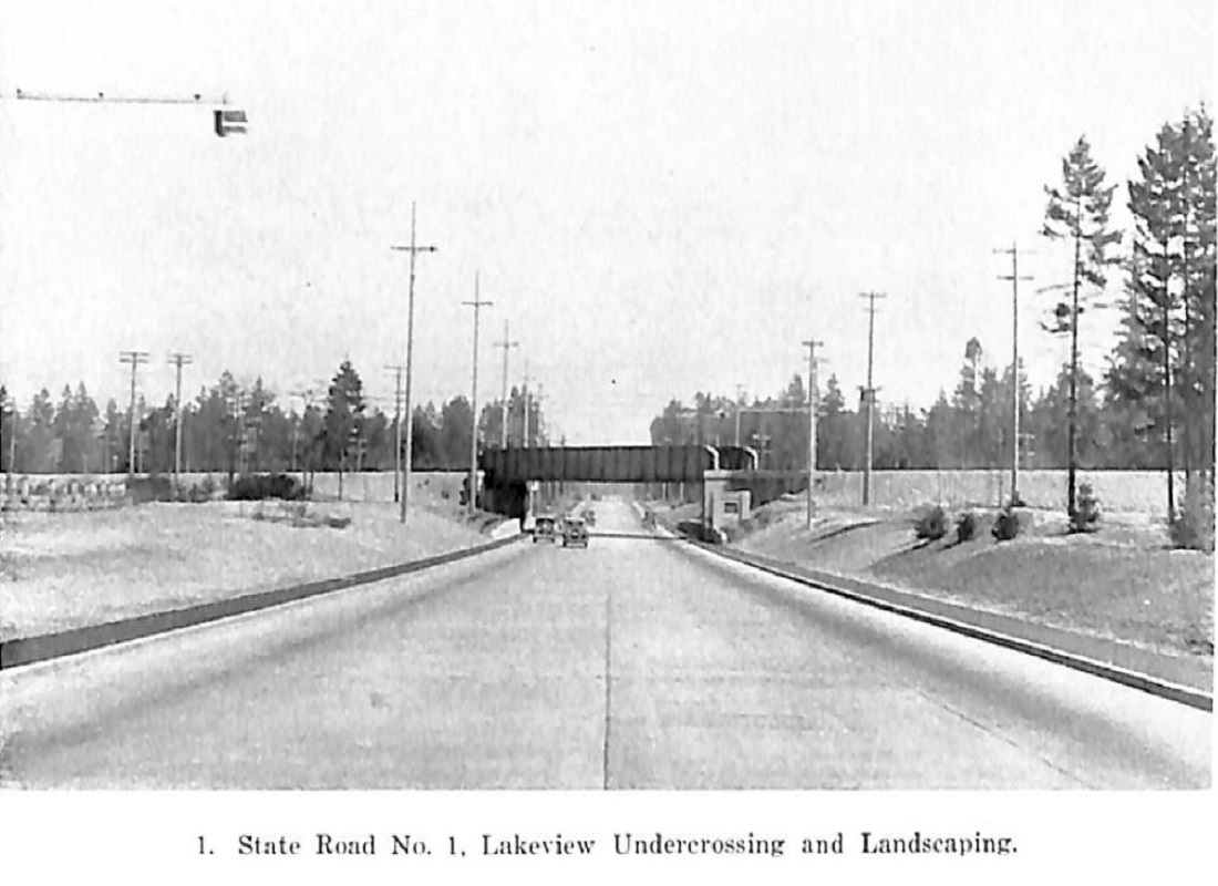
The 1937 Lakeview Undercrossing. |