![]()
The Historic Pacific Highway
in Washington
Capitol Boulevard / Capitol Way
![]()
The Historic Pacific Highway
in Washington
Capitol Boulevard / Capitol Way
History of Capitol Boulevard
By Curt Cunningham
The Old Pacific Highway
The first road between Tumwater and Olympia was built in 1853. This is when the first bridge over the Deschutes river was constructed. From downtown Olympia south to the city limits, the road was known as Main Street. In 1913, this road became a section of the Pacific Highway. In 1915 a concrete span replaced the old wooden bridge over the river between the falls, and is now known as the Boston Street bridge.
By 1935, the Pacific Highway through Tumwater had become obsolete. The 4 elbow-jointed turns that drivers had to negotiate on the old highway slowed traffic creating a bottleneck. All the traffic between Seattle and Portland was going through Tumwater. These sharp turns were all located near the Boston bridge, and it became a dangerous place for both drivers and pedestrians. In 1924, between July 21st and August 10th, a total of 3,193 vehicles which included 6 wagons, passed through Tumwater going southbound. Leaving Olympia traveling eastward toward Tacoma, there were a total of 5,539 vehicles, including 8 wagons.
In 1928 between July 21st and August 10th, 6,235 vehicles including 10 wagons passed through Tumwater traveling southbound. During that same time, 7,882 vehicles including 1 wagon passed through Olympia traveling eastward toward Tacoma. By the mid 1930's it was probably more than double that amount. Something had to be done to eliminate the dangerous bottleneck.
Capitol Boulevard /Capitol Way
In 1935, plans were made to eliminate the congestion on the Pacific Highway through Tumwater by constructing a new highway and bridge that would bypass the bottleneck. At the south end, this new road leaves the old alignment just north of Trosper Road and crosses the Deschutes river above the upper falls. The new road reconnects to the old Pacific Highway in East Tumwater at the north end of Cleveland Avenue. From Trosper Road to the Deschutes river, the road is a 4 lane divided highway, the first in Thurston county. Main Street would remain 2 lanes through Olympia to Lacey. Construction began in 1936 and took 2 years to complete.
In the Dispatch, volume 45, number 17, printed on March 30, 1938, it said that; "Marie Reiter who had been visiting with her parents, Mr. and Mrs. Fred Guske, had gone over to spend a few days with her sister, Toots Loser, at Olympia. Her sister's husband Herman Loser, was working on the new bridge at Tumwater which marks the end of the Oregon Trail, and is a beautiful monument to some of Washington State's historical background."
The bridge was dedicated on September 28, 1938 and was named the Carlyon bridge, after Phillip H, Carlyon. Carlyon was a Good Roads advocate, mayor of Olympia and also served in both house and senate as a member of the Washington State Legislature, serving the citizens of Thurston county. He served as Speaker from 1933 to 1935 and from 1945 to 1947. Carlyon was born on January 6, 1863 in Union Grove, WI., and was the son of William Ralph Carlyon.
At the beginning of the
dedication ceremony, the Olympia High School Band played for the guests. Afterward
Governor Clarence G. Martin gave a speech and when the ceremony was
completed, the mayors of Tumwater and Olympia cut the ribbon and let over
300 drivers who were anxiously waiting, cross over the new bridge.
The bridge has a decorative "Art Deco" design with rounded curves and
railings, along with 16 polychrome light poles that line the bridge. At each end of the bridge are concrete totem poles, created by the Olympia Stone Company of Seattle. The totem poles are a representation of
a Haida totem. Each totem pole has the depictions of; a raven, 2 bears, and an eagle.
At the bottom of the poles there are inscriptions.
At the north end of the bridge on the west side, the inscription reads; “Entrance to the City of Olympia Capital of the State of Washington.” On the opposite side along the northbound lanes, it reads; “Site of the First American Pioneer Settlement in Washington 1845.” At the south end of the bridge on the west side is; “South Gateway to the Puget Sound Country and the Olympic Peninsula.” On the opposite side is; “Beginning of the Inside Passage to British Columbia and Alaska.”
The bridge was engineered by Clark Eldridge, who was one of Washington State’s most notable and accomplished bridge engineers. When Eldridge was hired by the Washington State Highway Department in 1936, the Deschutes bridge was one of the first projects he undertook. After the Carlyon bridge was completed Eldridge went on to help build the Lake Washington Floating Bridge and the Tacoma Narrows Bridge.
Now that the Carlyon bridge was finished, the new highway diverted traffic away from Tumwater eliminating the dangerous bottleneck. With less traffic going through town, business began to suffer. Gas stations were the first to close, then the restaurants and merchants. Many of these businesses moved to the north end of the bridge in East Tumwater. The area would become known as Tumwater Square. Throughout the late 1930's and into the 1940's, Tumwater Square did a thriving business.
By the mid 1950's the landscape between Tumwater and Olympia would experience a drastic change. This is when the Olympia-Tumwater freeway began construction. When this new freeway was completed in 1958, the Seattle-Portland traffic bypassed both Olympia and Tumwater, forcing many businesses to move or close up shop. Tumwater's main business district shifted to the freeway interchange at Trosper Road, and Olympia's business center, which was located downtown, would began to grow between the Pacific Avenue interchange (Exit 107) and the Martin Way interchange (Exit 108) in Lacey. In 1966, South Sound Center was opened to shoppers, and it was billed as the 4th largest shopping center in the state.
Capitol Lake
Capitol Lake is a 260 acre artificial lake that was created when a dam was constructed submerging the tide flats between the Fourth Avenue bridge and the mouth of the Deschutes river. The first attempt to create a lake was in 1915, when former Olympia Mayor and state legislator Phillip H. Carlyon submitted a proposal to replace Olympia's Fourth Avenue bridge with a dam and locks. This plan would have created a lake very much like the present Capitol Lake. Because of opposition from the Olympia Brewing Company and the Olympia Power and Light Company, the plan was abandoned.
The first action to create the lake was in 1937 when the Legislature authorized the State Capitol Committee to develop and extend the state capitol grounds, seek Federal assistance, and make an appropriation of $150,000. The project called for the improvement of the area that was called the Des Chutes Water Basin.
In 1941, opposition from Tumwater was finally overcome during a special town meeting. In 1947, due in large part by intense lobbying by Thurston county legislators, the state legislature approved funding for the construction of the dam to create Capitol Lake. Construction was completed in 1951, and it is now a part of the Capitol campus.
Deschutes Parkway
The Capitol Lake project included a new route between Tumwater and Olympia called the Deschutes Parkway. Completed in 1953 this 1.68 mile state-owned roadway threads along the western shore of Capitol Lake. The roadway provided another route for motorists traveling between Tumwater and Olympia. This new road was built as a way to relieve the congestion on Capitol Way. Alongside the road is a jogging/bicycle path, which is popular with Olympia's residents.
Capitol Boulevard and Capitol Way continue to be an important transportation route serving tourists and locals, and is the south gateway to the Capitol building and surrounding campus. The Carlyon bridge continues to serve the traveling public and the bridge was placed on the National Register of Historic Places in 1982. In 2015, 17,500 cars were crossing the bridge daily.
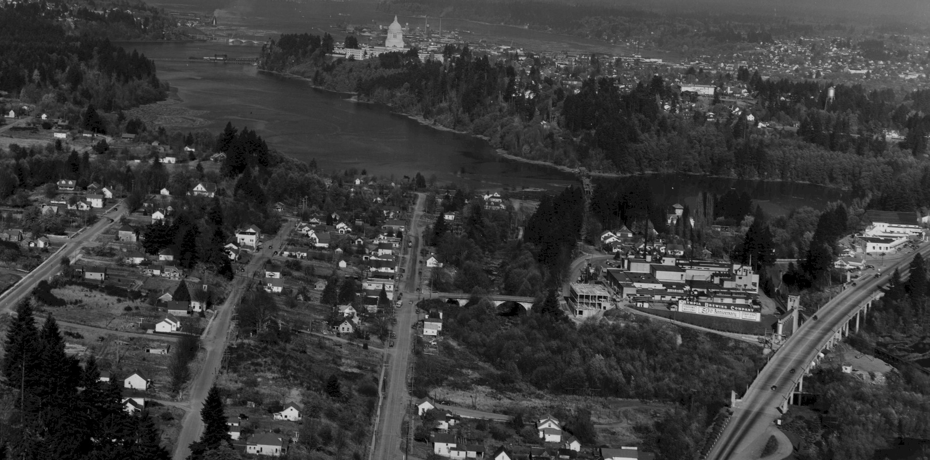
Olympia 1946 Photo courtesy Washington Digital Archives. 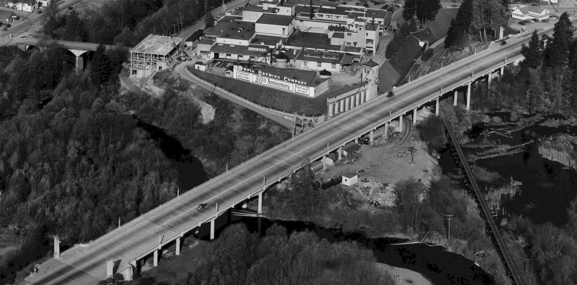
Carlyon Bridge 1946 Photo courtesy Washington Digital Archives. 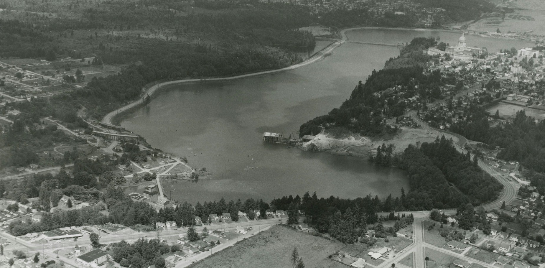
Olympia 1956 showing Capitol Blvd. and the freeway construction. Photo courtesy Washington Digital Archives 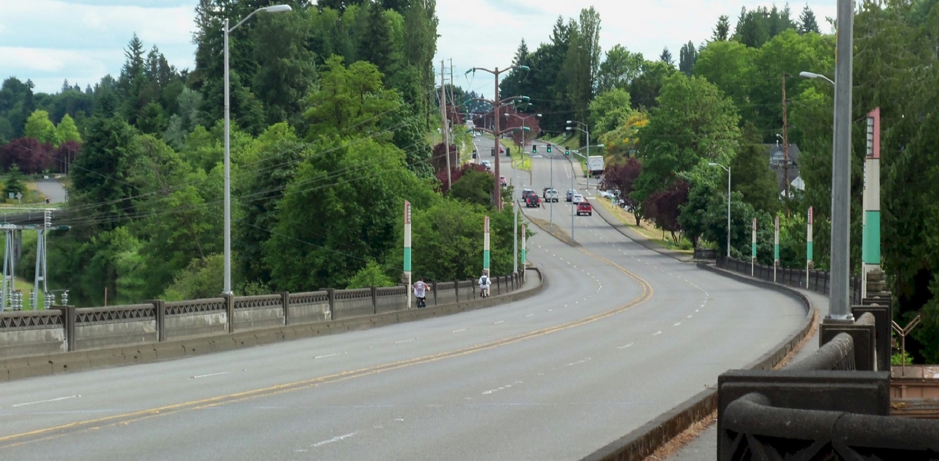
2019 photo of the Carlyon Bridge. Looking south. |
©2011-2022 pacific-hwy.net
All Rights Reserved