![]()
The Historic Pacific Highway
in Washington
Bellingham to Blaine
![]()
The Historic Pacific Highway
in Washington
Bellingham to Blaine
The first bridge across Whatcom Creek was constructed in 1857 by the U.S. Army for the Military Road which which was to be constructed between Fort Steilacoom and Fort Bellingham. On August 26, 1856 Captain George Pickett arrived in Bellingham by ship with a company of soldiers. After landing on the shore he found about 30 frightened settlers who had crowded into the blockhouses to sleep at night. These settlers were completely defenseless and were glad to see the soldiers.
Leaving Bellingham heading north, the original Pacific Highway followed the Northwest Diagonal Road which is now called Northwest Drive. At W. Axton Road, the highway turned left and continued west toward Ferndale. At the intersection of W. Axton Road and Barrett Road, the highway turned south for a quarter mile and then turned west onto what is now La Bounty Drive and continued into Ferndale. This quarter mile of highway south of Barrett Road was abandoned in the 1960's when the freeway came through making this small section a ghost road.
Ferndale is located about 8 miles northwest of Bellingham on the Nooksack River. The area was originally called Te-tas-um by the Lummi people and was at the lower crossing of the Nooksack River. The upper crossing of the river was at Everson. The town was named for the ferns which were found in abundance there.
Portal Way is a 10 mile section of the Pacific Highway between Ferndale and Dakota Creek. The creek is about 2 miles southeast of Blaine. This section of the highway was built in stages between 1914 and 1928 and it runs alongside the old Great Northern railroad tracks (now BNSF). This new highway gave travelers a straighter and shorter road between Ferndale and Blaine which saved about 5 miles off the route through Pleasant Valley.
The early wagon road into Blaine from Bellingham after crossing Dakota Creek ran north on what is now known as Bell Road. Before the Freeway was constructed, Bell Road ran directly north to meet Hughes Avenue. The highway then traveled west to Bayview Avenue where it turned right and continued north to Adelia Street. At Adelia Street the highway turned left and traveled west to Harrison Avenue. This would be the route of the Pacific Highway until 1928.
The first Peace Arch was built during the summer of 1915 when the Vancouver B.C. Automobile Club erected an arch made of logs. On the side they attached a copper plaque that read; "Erected by the Vancouver Automobile Club in commemoration of the Peace Centenary 5 July 1915." This commemorated the 100 years of peace between Great Britain and the United States.
Austin Pass Branch of the Pacific Highway
The Mount Baker Scenic Highway begins in downtown Bellingham and travels almost 60 miles eastward, with the last 24 miles through "insurmountable mountains capped with perpetual snow." The highway terminates at Artist Point 5,100 feet above sea level and is 4 miles northwest of Mount Shuksan and 9 miles northeast of Mount Baker. The highway travels through some of the most beautiful scenery in Washington state and is a destination for hikers, skiers, hunters, prospectors and anyone who wants to get away from the hustle and bustle of city life.
The Whatcom Trail and the Gold Rush of 1858
During the spring of 1858, rumors of a new gold discovery on the Fraser River made its way to Puget Sound. Captain Jones of the schooner Wild Pigeon, brought word that gold could be found along the river between Fort Yale and the forks of the Thompson River. He said that most of the inhabitants around Fort Victoria and Fort Langley had already left for the diggings. The trappers were now becoming prospectors. The Chief Factor of Fort Langley immediately left the fort with food and merchandise, leaving only a clerk in charge. The Hudson’s Bay Company (HBC) blacksmith had been working day and night making picks and shovels for these new miners.
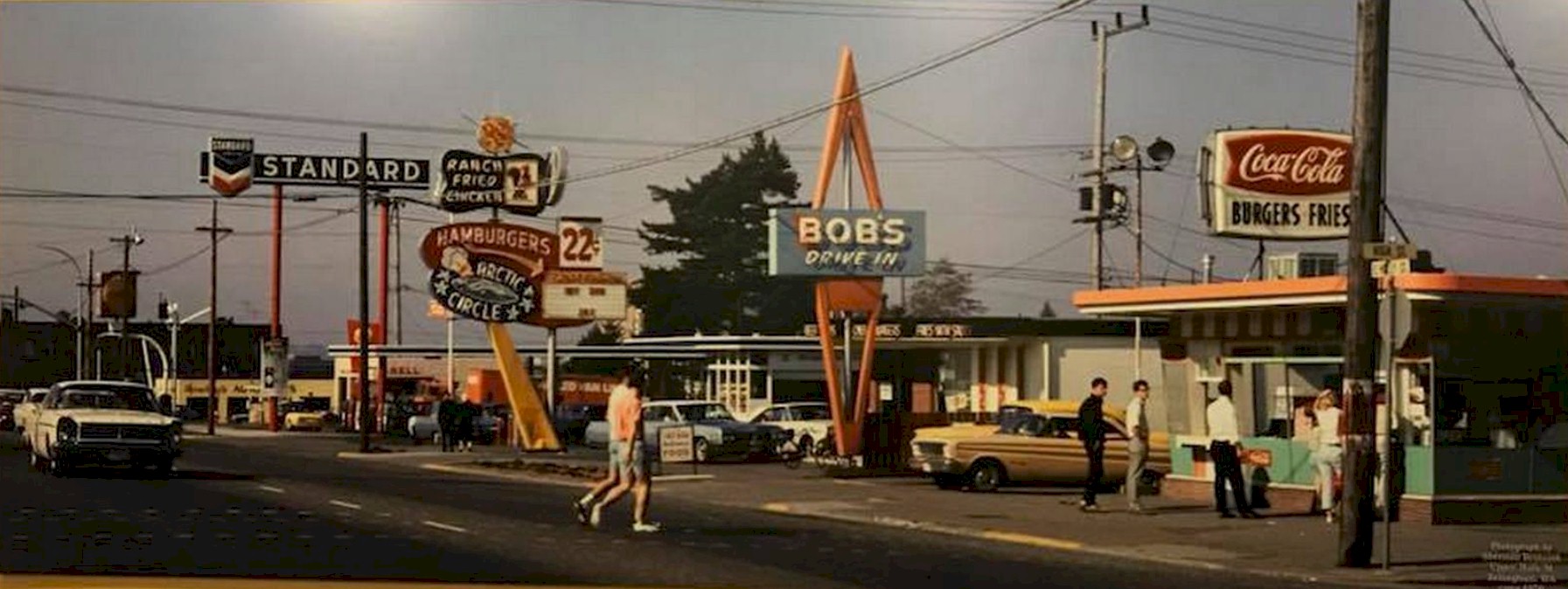
Holly & High St. 1960's
Photo courtesy of Reddit user;
Brandonnn
From former Bellingham resident Jeff Fox; Bob's Drive was located in Bellingham's first Dairy Queen. This is the same building. As a kid, I used to go to DQ and get a soft ice cream cone for 5 cents. The man who ran it was all by himself. In the 1970's this same man rode my bus and we would reminisce about the old DQ. The Arctic Circle came into being I believe in the late 1950's. It later operated under a few different names. Dandy's in the early 1980's, then as the Cattleman's where they had super breakfasts.
The Standard Station was operated by Bob Miles was a real nice guy. His wife was a counter waitress in Woolworth's for many years at the Luncheonette. The Shell Station was owned for years by Clarence Milne. He was a neighbor of ours. His son Larry worked for his dad and when Clarence retired, Larry took it over. I used Larry for years as my mechanic. The next building down (the yellow one) was Hawley's Auto Parts. Their Bldg was originally a gas station and while they were there, the overhead doors were still intact. It was a thriving business.
The dark building in the distance was the original YMCA, and this building to my knowledge is still there. I believe that it also served as the Odd Fellow's Hall, but I am not sure anymore. Holly was originally brick from Bay Street to I believe Indian Street then it was sheet asphalt. The bricks were different according to blocks. There were 2 sets of trolley tracks also. Holly was overlaid in 1937, but the trolleys were still in service and then in 1939, the tracks were covered when busses made their advent.

©2011-2022 pacific-hwy.net
All Rights Reserved